























Message from the system: You need to be logged in to share images. You can either log in or create a new user.

Message from the system: You need to be logged in to update a harbour. You can either log in or create a new user.

Message from the system: You need to be logged in to suggest new wind directions. You can either log in or create a new user.

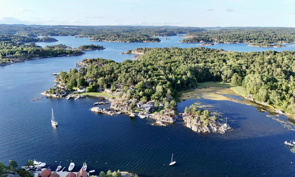
Ågerøya naturhavn: {"base": "nl", "no": "Flott ankringsplass, god ankerbunn. Noe b\u00e5ttrafikk fra beboere", "se": "Vacker ankringsplats, bra ankarbotten. Dock en del b\u00e5ttrafik fr\u00e5n inv\u00e5nare", "en": "Beautiful anchorage, good holding ground. Some boat traffic from residents.", "da": "Smukt ankerplads, god ankerbund. Dog en del b\u00e5dtrafik fra beboere", "fr": "Beau mouillage, bon fond pour l'ancrage. Cependant, il y a un peu de trafic de bateaux des r\u00e9sidents", "de": "Sch\u00f6ner Ankerplatz, guter Ankergrund. Allerdings etwas Bootsverkehr von den Anwohnern.", "es": "Bonito lugar de anclaje, buen fondo de anclaje. Sin embargo, algo de tr\u00e1fico de embarcaciones de residentes", "it": "<p>Bella ancoraggio, buon fondale per l'ancora. Un po' di traffico di barche da parte dei residenti.</p>", "pt": "Belo ancoradouro, bom fundo para ancoragem. No entanto, h\u00e1 algum tr\u00e1fego de barcos dos residentes", "nl": "Mooie ankerplaats , goede ankergrond. Wel wat bootverkeer van bewoners", "pl": "Pi\u0119kne miejsce do kotwiczenia, dobre miejsce do zakotwiczenia. Troch\u0119 ruchu \u0142odzi od mieszka\u0144c\u00f3w", "uk": "\u0413\u0430\u0440\u043d\u0430 \u044f\u043a\u0456\u0440\u043d\u0430 \u0441\u0442\u043e\u044f\u043d\u043a\u0430, \u0445\u043e\u0440\u043e\u0448\u0435 \u0434\u043d\u043e \u0434\u043b\u044f \u044f\u043a\u043e\u0440\u044f. \u041e\u0434\u043d\u0430\u043a \u0442\u0440\u043e\u0445\u0438 \u0440\u0443\u0445\u0443 \u0432\u0456\u0434 \u043c\u0456\u0441\u0446\u0435\u0432\u0438\u0445 \u0436\u0438\u0442\u0435\u043b\u0456\u0432", "ro": "Frumoad\u0103 zon\u0103 de ancorare, fund bun pentru ancorare. Totu\u0219i, exist\u0103 ceva trafic de ambarca\u021biuni de la reziden\u021bi.", "tr": "G\u00fczel bir demirleme yeri, iyi demirleme zemini. Yine de baz\u0131 sakinlerin tekne trafi\u011fi var.", "el": "\u03a9\u03c1\u03b1\u03af\u03bf \u03b1\u03b3\u03ba\u03c5\u03c1\u03bf\u03b2\u03cc\u03bb\u03b9\u03bf, \u03ba\u03b1\u03bb\u03cc\u03c2 \u03b2\u03c5\u03b8\u03cc\u03c2 \u03b3\u03b9\u03b1 \u03b1\u03b3\u03ba\u03cd\u03c1\u03c9\u03c3\u03b7. \u03a5\u03c0\u03ac\u03c1\u03c7\u03b5\u03b9 \u03ba\u03ac\u03c0\u03bf\u03b9\u03b1 \u03ba\u03af\u03bd\u03b7\u03c3\u03b7 \u03c3\u03ba\u03b1\u03c6\u03ce\u03bd \u03b1\u03c0\u03cc \u03c4\u03bf\u03c5\u03c2 \u03ba\u03b1\u03c4\u03bf\u03af\u03ba\u03bf\u03c5\u03c2.", "cs": "Kr\u00e1sn\u00e9 kotvi\u0161t\u011b, dobr\u00e9 dno pro kotven\u00ed. Pom\u011brn\u011b trochu lodn\u00edho provozu od obyvatel", "hu": "Sz\u00e9p horgonyz\u00f3hely, j\u00f3 horgonyz\u00f3 talaj. Az ott \u00e9l\u0151k haj\u00f3forgalma kiss\u00e9 zavar\u00f3 lehet.", "fi": "Kaunis ankkuripaikka, hyv\u00e4 ankkuripohja. Jonkin verran veneilyliikennett\u00e4 asukkaiden toimesta", "bg": "\u0425\u0443\u0431\u0430\u0432\u043e \u043c\u044f\u0441\u0442\u043e \u0437\u0430 \u0437\u0430\u043a\u043e\u0442\u0432\u044f\u043d\u0435, \u0434\u043e\u0431\u0440\u0430 \u0430\u043d\u043a\u0435\u0440\u043d\u0430 \u043f\u043e\u0447\u0432\u0430. \u041c\u0430\u043b\u043a\u043e \u043a\u043e\u0440\u0430\u0431\u0435\u043d \u0442\u0440\u0430\u0444\u0438\u043a \u043e\u0442 \u043c\u0435\u0441\u0442\u043d\u0438 \u0436\u0438\u0442\u0435\u043b\u0438.", "sr": "Lepo sidri\u0161te, dobra podloga za sidrenje. Ipak, ima ne\u0161to prometa brodova od stanovnika.", "et": "Ilus ankrukoht, hea ankrup\u00f5hi. Veidi kohalike elanike paadiliiklust", "lv": "Skaista enkuro vieta, laba enkura zeme. Gan nedaudz viet\u0113jo iedz\u012bvot\u0101ju laivu satiksmes.", "lt": "Gera inkaravimo vieta, tinkamas inkarinis dugnas. Ta\u010diau yra \u0161iek tiek vietini\u0173 gyventoj\u0173 laiv\u0173 jud\u0117jimo"}
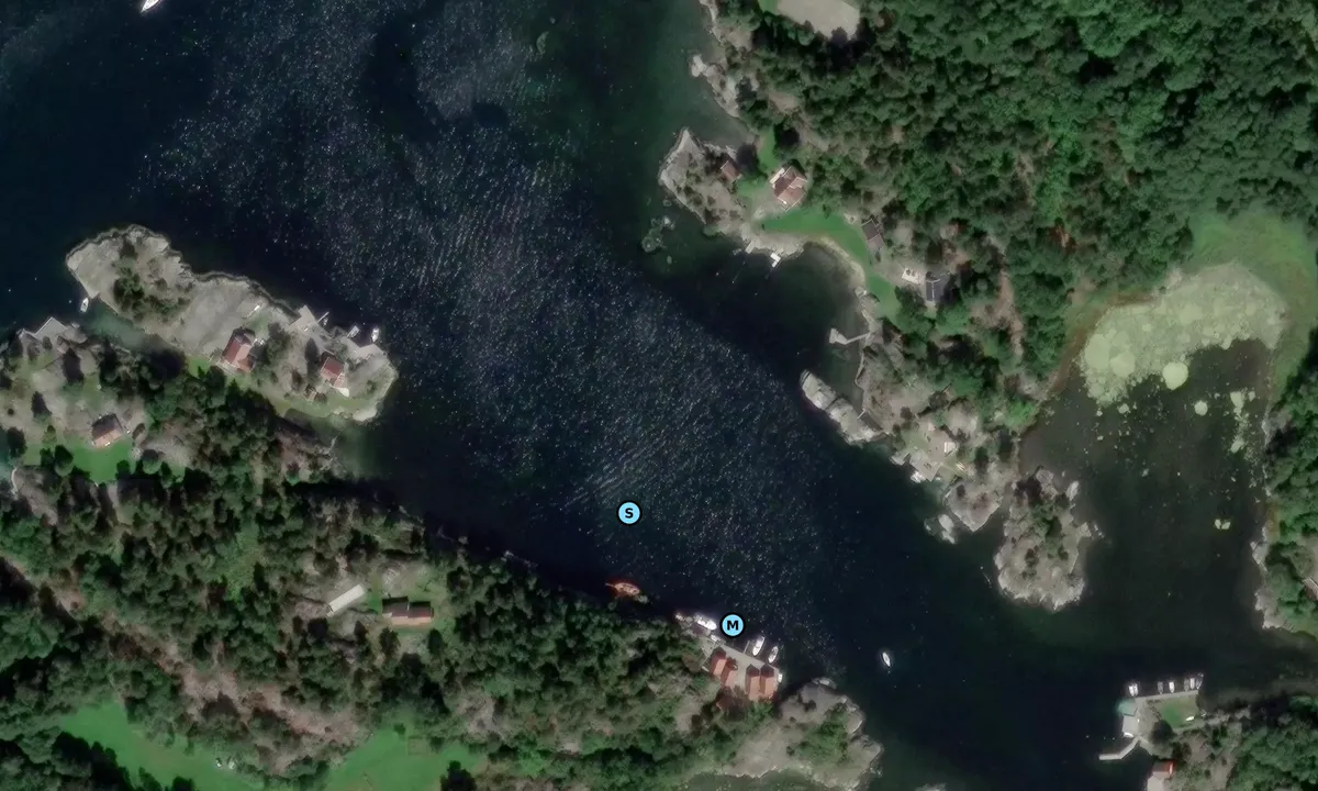
Satelite image of Ågerøya naturhavn

📸 Upload a photo

Show off your photos and help others plan their journey to Ågerøya naturhavn.harbourmaps.com is created by the sailing community, in a collective effort to make cruising simpler and more fun. Uploading a photo takes less than a minutes and can be done from your phone, tablet or laptop.

📸 Upload a photo

Facilities

We don't have any data on available facilities in this harbour. If you know which facilities are available here, please update this site to help your fellow sailors. Update facilities.

Mooring

Options for mooring in this harbour: Anchoring.

Updated on 2. Aug 2026. Update mooring.

Descriptions and reviews

Wilco Brouwer says:

area

maritime qualities

description

Anchoring in the middle, excellent anchorage at 8 meters depth

[translated from Dutch with AI]

1 x helpful | written on 2. Aug 2026

Do you know this harbour? It's a huge help to other sailors if you add a short description or review of the harbour.

📜 Add description

Map of Ågerøya naturhavn

Facilities

We don't have any data on available facilities in this harbour. If you know which facilities are available here, please update this site to help your fellow sailors. Update facilities.

Mooring

Options for mooring in this harbour: Anchoring.

Updated on 2. Aug 2026. Update mooring.

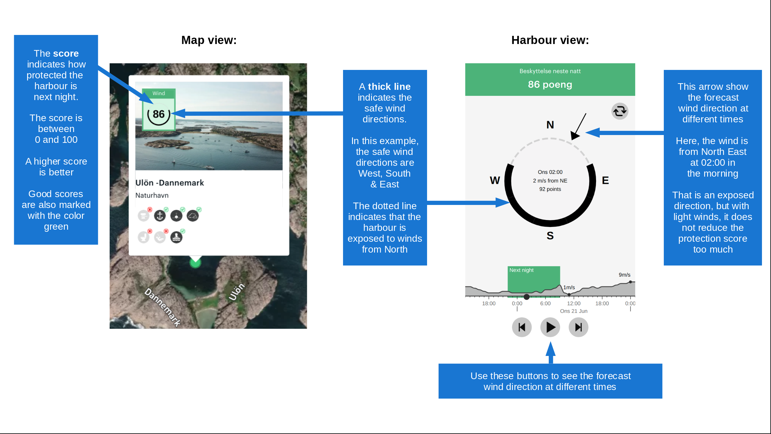
Wind protection

Protection next night

85 points

N E S W --> } } } } } } } } } } } } } } } } } } } } } } } } } } } } } } } } } } } } } } } } } } } } } } } } } } } } } } } } } } } } } } } } } } } } } } } } } } } } } } } } } } } } } } } } } } } } } } } } } } } } } } } } } } } } } } } } } } } } } } } } } } } } } } } } } } } } } } } } } } } } } } } } } } } } } } } } } } } } } } } } } } } } } } } } } } } } } } } } } } } } } } } } } } } } } } } } } } } } } } } } } } } } } } } } } } } } } } } } } } } } } } } } } } } } } } } } } } } } } } } } } } } } } } } } } } } } } } } } } } } } } } } } } } } } } } } } } } } } } } } } } } } } } } } } } } } } } } } } } } } } } } } } } } } } } } } } } } } } } } } } } } } } } } } } } } } } } } } } } } } } } } } } } } } } } } } } } } } } } } } } } } } } } } } } } } } } } } } } } } } } } } } } } } } } } } } } } } } } } } } } } } } } } } } } } } } } } } } } } } } } } } } } } } } } } } } } } } } } } } } } } } } } } } } } } } } } } } } } } } } } } } } } } } } } } } } } } } } } } } } } } } } } } } } } } } } } } } } } } } } } } } } } } } } } } } } } } } } } } } } } } } } } } } } } } } } } } } } } } } } } } } } } } } } } } } } } } } } } } } } } } } } } } } } } } } } } } } } } } } } } } } } } } } } } } } } } } } } } } } } } } } } } } } } } } } } } } } } } } } } } } } } } } } } } } } } } } } } } } } } } } } } } } } } } } } } } } } } } } } } } } } } } } } } } } } } } } } } } } } } } } } } } } } } } } } } } } } } } } } } } } } } } } } } } } } } } } } } } } } } } } } } } } } } } } } } } } } } } } } } } } } } } } } } } } } } } } } } } } } } } } } } } } } } } } } } } } } } } } } } } } } } } } } } } } } } } } } } } } } } } } } } } } } } } } } } } } } } } } } } } } } } } } } } } } } } } } } } } } } } } } } } } } } } } } } } } } } } } } } } } } } } } } } } } } } } } } } } } } } } } } } } } } } } } } } } } } } } } } } } } } } } } } } } } } } } } } } } } } } } } } } } } } } } } } } } } } } } } } } } } } } } } } } } } } } } } } } } } } } } } } } } } } } } } } } } } } } } } } } } } Next night 18:00 0:00 6:00 12:00 Søn 20 Sep 18:00 0:00 7m/s 4m/s

Want to know how the wind score works? Then you should read this explanation.

The wind forecasts come from yr.no (Norwegian Meteorological Institute), and was last updated 1 hour and 24 minutes ago (Saturday 19 September 03:29 PM). The next night score shows you the worst hour between 22:00 and 08:00 the next night. We recommend that you check multiple sources for wind forecasts. windy.com is a good website to show larger wind systems.

The safe wind directions for this harbour has been decided by an algorithm, based on how elevated the land around the harbour is. It's mostly correct, but sometimes the underlying data about elevation levels is not good enough to make correct decisions. It's a great help to other if you can validate or adjust the safe wind directions. You can see the data used by the algorithm to decide the safe wind directions by clicking here.

Last visits to Ågerøya naturhavn

Thu 10 Jul 2025

VILJA [MMSI: 258262830]

Fri 12 Jul 2024

BLUES BREAKER [MMSI: 219011549]

Sat 02 Sep 2023

SLEIPNER [MMSI: 258158060]

Fri 04 Aug 2023

HAPPY [MMSI: 258143960]

Sun 23 Jul 2023

BAADE & [MMSI: 258077220]

The visits are retrieved from AIS data. You can click to see all visiting ships to Ågerøya naturhavn, as well as statistics about the ships that visits

Add this harbour to a journey

Check in now

Choose a different date than today

Important: When you check in to a harbour, you add it to a journey on this website. You are not booking a place in the marina.

Contributors

Users that contributed to this page: Wilco Brouwer

harbourmaps.com is updated by the boating community. When you add information, a review or pictures to this page you are listed here with the other contributors (we list your user-name, which can be your real name or a pseudonym).

Closest harbours to Ågerøya naturhavn

Filter by

Natural harbour
Marina
Safe wind next night

Order by

ABC
Popularity
Wind score next night

0 harbours

Show more harbours