Bjellebøvågen bukt

Natural harbour

favoritt

Region: Norway (3423), Vestland (599), Hordaland (393), Kvinnherad (43), Arnavik (9) and Fjelberg (7)

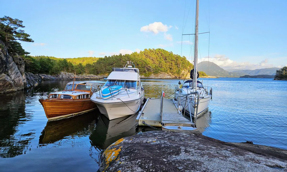
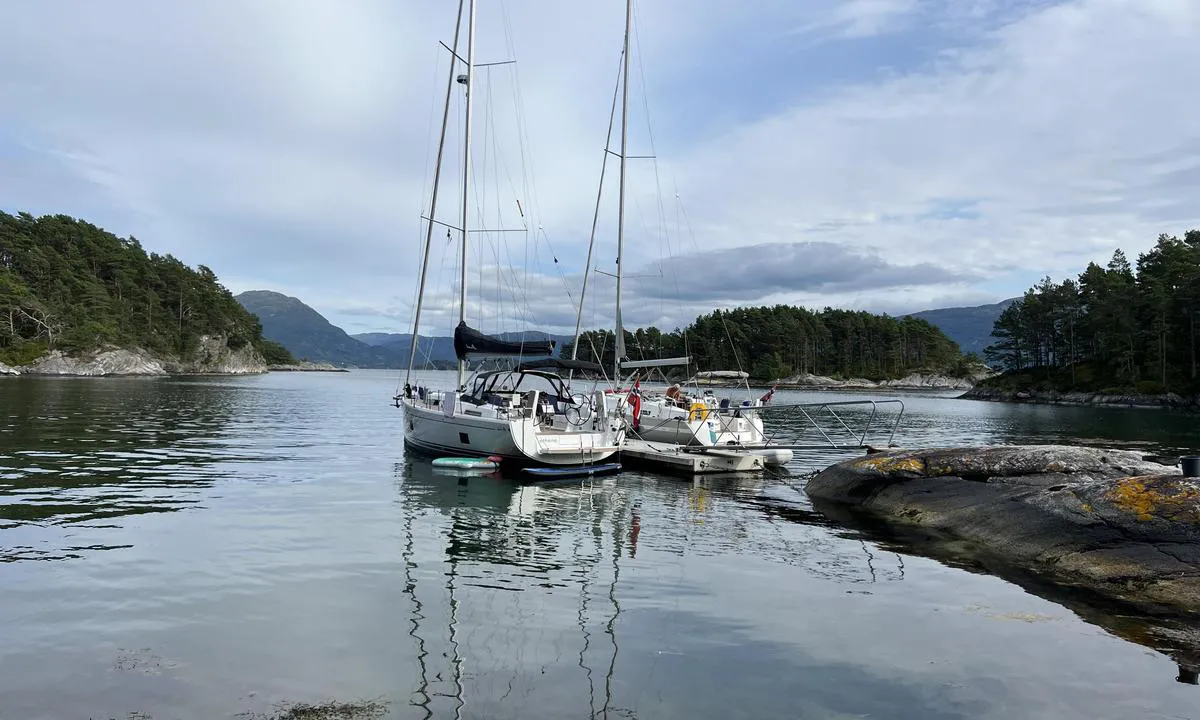
Bjellebøvågen bukt: {"base": "no", "no": "Solid flytebrygge i betong, ca 10 m lang. Grei dybde, ca 2.3 m ved lavvann.", "se": "Solid flytbrygga i betong, ca 10 m l\u00e5ng. Bra djup, ca 2,3 m vid l\u00e5gvatten.", "en": "Solid floating dock made of concrete, approximately 10 m long. Adequate depth, about 2.3 m at low tide.", "da": "Solid flydebro i beton, ca. 10 m lang. Fornuftig dybde, ca. 2,3 m ved lavvande.", "fr": "Quai flottant solide en b\u00e9ton, environ 10 m de long. Profondeur ad\u00e9quate, environ 2,3 m \u00e0 mar\u00e9e basse.", "de": "Solide Schwimmsteganlage aus Beton, ca. 10 m lang. G\u00fcnstige Tiefe, ca. 2,3 m bei Niedrigwasser.", "es": "Muelle flotante s\u00f3lido de concreto, de aproximadamente 10 m de largo. Profundidad aceptable, aproximadamente 2.3 m en marea baja.", "it": "Solido pontile galleggiante in cemento, lungo circa 10 m. Profondit\u00e0 adeguata, circa 2,3 m con la bassa marea.", "pt": "Cais flutuante s\u00f3lido em concreto, cerca de 10 m de comprimento. Profundidade adequada, cerca de 2,3 m na mar\u00e9 baixa.", "nl": "Solide betonnen drijvende steiger, ongeveer 10 m lang. Redelijke diepte, ongeveer 2,3 m bij laag water.", "pl": "Solidny p\u0142ywaj\u0105cy pomost betonowy, d\u0142ugo\u015b\u0107 oko\u0142o 10 m. Odpowiednia g\u0142\u0119boko\u015b\u0107, oko\u0142o 2,3 m przy niskim stanie wody.", "uk": "\u0421\u0443\u0446\u0456\u043b\u044c\u043d\u0430 \u043f\u043b\u0430\u0432\u0443\u0447\u0430 \u0431\u0435\u0442\u043e\u043d\u043d\u0430 \u043f\u0440\u0438\u0441\u0442\u0430\u043d\u044c, \u043f\u0440\u0438\u0431\u043b\u0438\u0437\u043d\u043e 10 \u043c \u0437\u0430\u0432\u0434\u043e\u0432\u0436\u043a\u0438. \u041d\u0430\u043b\u0435\u0436\u043d\u0430 \u0433\u043b\u0438\u0431\u0438\u043d\u0430, \u043f\u0440\u0438\u0431\u043b\u0438\u0437\u043d\u043e 2,3 \u043c \u043f\u0440\u0438 \u0432\u0456\u0434\u043f\u043b\u0438\u0432\u0456.", "ro": "Solid ponton plutitor din beton, de aproximativ 10 m lungime. Ad\u00e2ncime acceptabil\u0103, aproximativ 2.3 m la maree joas\u0103.", "tr": "Betonarme sa\u011flam bir y\u00fczer iskele, yakla\u015f\u0131k 10 m uzunlu\u011funda. Uygun derinlik, d\u00fc\u015f\u00fck su seviyesinde yakla\u015f\u0131k 2.3 m.", "el": "\u03a3\u03c4\u03b1\u03b8\u03b5\u03c1\u03ae \u03c0\u03bb\u03c9\u03c4\u03ae \u03c0\u03c1\u03bf\u03b2\u03bb\u03ae\u03c4\u03b1 \u03b1\u03c0\u03cc \u03c3\u03ba\u03c5\u03c1\u03cc\u03b4\u03b5\u03bc\u03b1, \u03c0\u03b5\u03c1\u03af\u03c0\u03bf\u03c5 10 \u03bc\u03ad\u03c4\u03c1\u03b1 \u03bc\u03b1\u03ba\u03c1\u03b9\u03ac. \u039a\u03b1\u03bb\u03ae \u03b2\u03ac\u03b8\u03bf\u03c2, \u03c0\u03b5\u03c1\u03af\u03c0\u03bf\u03c5 2,3 \u03bc\u03ad\u03c4\u03c1\u03b1 \u03c3\u03c4\u03bf \u03c7\u03b1\u03bc\u03b7\u03bb\u03cc \u03bd\u03b5\u03c1\u03cc.", "cs": "Pevn\u00e9 pontonov\u00e9 molo z betonu, cca 10 m dlouh\u00e9. P\u0159im\u011b\u0159en\u00e1 hloubka, cca 2,3 m p\u0159i odlivu.", "hu": "Szil\u00e1rd beton \u00fasz\u00f3m\u00f3l\u00f3, kb. 10 m hossz\u00fa. Megfelel\u0151 m\u00e9lys\u00e9g, ap\u00e1lykor kb. 2,3 m.", "fi": "Vankka betonista kelluva laituri, noin 10 m pitk\u00e4. Hyv\u00e4 syvyys, noin 2,3 m alavedell\u00e4.", "bg": "\u0421\u043e\u043b\u0438\u0434\u043d\u043e \u0431\u0435\u0442\u043e\u043d\u043d\u043e \u043f\u043b\u0430\u0432\u0430\u0449\u043e \u043f\u0440\u0438\u0441\u0442\u0430\u043d\u0438\u0449\u0435, \u0434\u044a\u043b\u0433\u043e \u043e\u043a\u043e\u043b\u043e 10 \u043c. \u0417\u0430\u0434\u043e\u0432\u043e\u043b\u0438\u0442\u0435\u043b\u043d\u0430 \u0434\u044a\u043b\u0431\u043e\u0447\u0438\u043d\u0430, \u043e\u043a\u043e\u043b\u043e 2.3 \u043c \u043f\u0440\u0438 \u043e\u0442\u043b\u0438\u0432.", "sr": "\u010cvrst plutaju\u0107i betonski gat, pribli\u017eno 10 m dug. Odgovaraju\u0107a dubina, oko 2,3 m pri oseci.", "et": "Tahke betoonist ujuvkai, umbes 10 m pikk. Hea s\u00fcgavus, umbes 2,3 m m\u00f5\u00f5na ajal.", "lv": "<p>Stingra peldo\u0161a betona piest\u0101tne, apm\u0113ram 10 m gara. Piem\u0113rots dzi\u013cums, apm\u0113ram 2,3 m pie b\u0113guma.</p>", "lt": "Tvirta betono pl\u016bduriuojanti prieplauka, apie 10 m ilgio. Pakankamas gylis, apie 2.3 m prie \u017eemo potvynio."}
Bjellebøvågen bukt: {"base": "no", "no": "God dybde p\u00e5 seilb\u00e5ter. Liten brygge. Eksponert mot syd \u00f8st.", "se": "Bra djup f\u00f6r segelb\u00e5tar. Liten brygga. Utsatt f\u00f6r sydostvindar.", "en": "Good depth for sailboats. Small dock. Exposed to the southeast.", "da": "God dybde for sejlb\u00e5de. Lille bro. Eksponeret mod syd\u00f8st."}
Satelite image of Bjellebøvågen bukt

📸 Upload a photo

Show off your photos and help others plan their journey to Bjellebøvågen bukt.harbourmaps.com is created by the sailing community, in a collective effort to make cruising simpler and more fun. Uploading a photo takes less than a minutes and can be done from your phone, tablet or laptop.

📸 Upload a photo

Facilities

Available facilities: Swimming area.

Updated on 27. Jul 2024. Update facilities.

Mooring

Options for mooring in this harbour: To pier/wharf, Towards land.

Updated on 27. Jul 2024. Update mooring.

Descriptions and reviews

Langfallet says:

area

maritime qualities

description

Floating dock with room for two boats. Depth suitable for sailboats. Possibility to moor against cliffs as well (bolts available). Fire pit.

[translated from Norwegian with AI]

2 x helpful | written on 21. Jul 2024

Do you know this harbour? It's a huge help to other sailors if you add a short description or review of the harbour.

📜 Add description

Map of Bjellebøvågen bukt

Facilities

Available facilities: Swimming area.

Updated on 27. Jul 2024. Update facilities.

Mooring

Options for mooring in this harbour: To pier/wharf, Towards land.

Updated on 27. Jul 2024. Update mooring.

Wind protection

Protection next night

62 points

N E S W --> } } } } } } } } } } } } } } } } } } } } } } } } } } } } } } } } } } } } } } } } } } } } } } } } } } } } } } } } } } } } } } } } } } } } } } } } } } } } } } } } } } } } } } } } } } } } } } } } } } } } } } } } } } } } } } } } } } } } } } } } } } } } } } } } } } } } } } } } } } } } } } } } } } } } } } } } } } } } } } } } } } } } } } } } } } } } } } } } } } } } } } } } } } } } } } } } } } } } } } } } } } } } } } } } } } } } } } } } } } } } } } } } } } } } } } } } } } } } } } } } } } } } } } } } } } } } } } } } } } } } } } } } } } } } } } } } } } } } } } } } } } } } } } } } } } } } } } } } } } } } } } } } } } } } } } } } } } } } } } } } } } } } } } } } } } } } } } } } } } } } } } } } } } } } } } } } } } } } } } } } } } } } } } } } } } } } } } } } } } } } } } } } } } } } } } } } } } } } } } } } } } } } } } } } } } } } } } } } } } } } } } } } } } } } } } } } } } } } } } } } } } } } } } } } } } } } } } } } } } } } } } } } } } } } } } } } } } } } } } } } } } } } } } } } } } } } } } } } } } } } } } } } } } } } } } } } } } } } } } } } } } } } } } } } } } } } } } } } } } } } } } } } } } } } } } } } } } } } } } } } } } } } } } } } } } } } } } } } } } } } } } } } } } } } } } } } } } } } } } } } } } } } } } } } } } } } } } } } } } } } } } } } } } } } } } } } } } } } } } } } } } } } } } } } } } } } } } } } } } } } } } } } } } } } } } } } } } } } } } } } } } } } } } } } } } } } } } } } } } } } } } } } } } } } } } } } } } } } } } } } } } } } } } } } } } } } } } } } } } } } } } } } } } } } } } } } } } } } } } } } } } } } } } } } } } } } } } } } } } } } } } } } } } } } } } } } } } } } } } } } } } } } } } } } } } } } } } } } } } } } } } } } } } } } } } } } } } } } } } } } } } } } } } } } } } } } } } } } } } } } } } } } } } } } } } } } } } } } } } } } } } } } } } } } } } } } } } } } } } } } } } } } } } } } } } } } } } } } } } } } } } } } } } } } } } } } } } } } } } } } } } } } } } } } } } } } } } } } } } } } } } } } } } } } } } } } } } } } } } } } Next night 6:00 12:00 Ons 03 Sep 18:00 0:00 6:00 12:00 Tor 04 Sep 8m/s 2m/s

Want to know how the wind score works? Then you should read this explanation.

The wind forecasts come from yr.no (Norwegian Meteorological Institute), and was last updated 1 hour and 19 minutes ago (Wednesday 03 September 05:27 AM). The next night score shows you the worst hour between 22:00 and 08:00 the next night. We recommend that you check multiple sources for wind forecasts. windy.com is a good website to show larger wind systems.

The safe directions for this harbour was added at 21. Jul 2024. Click here to edit.

Last visits to Bjellebøvågen bukt

Thu 18 Jul 2024

BRIS [MMSI: 258122170]

Thu 07 Sep 2023

PEACHES [MMSI: 257034510]

RANJA [MMSI: 912571546]

Wed 02 Aug 2023

GUNILLA [MMSI: 258015380]

The visits are retrieved from AIS data. You can click to see all visiting ships to Bjellebøvågen bukt, as well as statistics about the ships that visits

Add this harbour to a journey

Check in now

Choose a different date than today

Important: When you check in to a harbour, you add it to a journey on this website. You are not booking a place in the marina.

Contributors

Users that contributed to this page: Kviteravn, Suse / SY Ronja and Langfallet

harbourmaps.com is updated by the boating community. When you add information, a review or pictures to this page you are listed here with the other contributors (we list your user-name, which can be your real name or a pseudonym).

Closest harbours to Bjellebøvågen bukt

Filter by

Natural harbour
Marina
Safe wind next night

Order by

ABC
Popularity
Wind score next night

0 harbours

Show more harbours