























Bragdøya, østre

Natural harbour

favoritt

Region: Norway (3530), Agder (292), Vest-Agder (149) and Kristiansand (51)

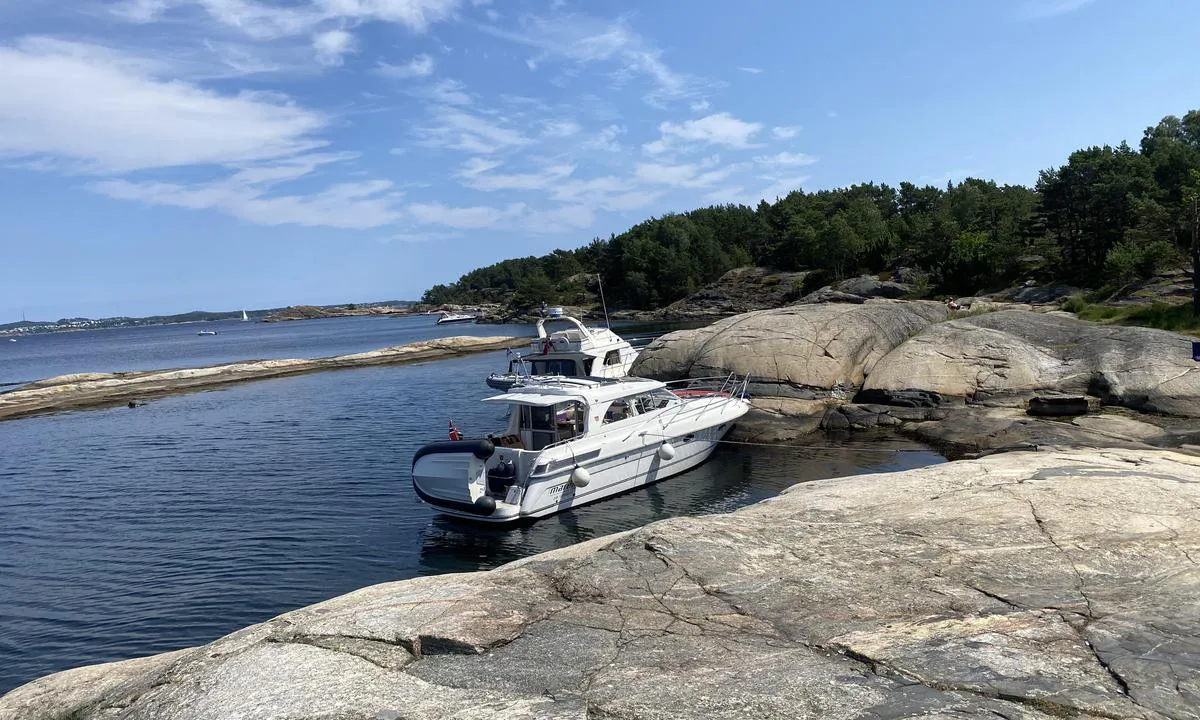
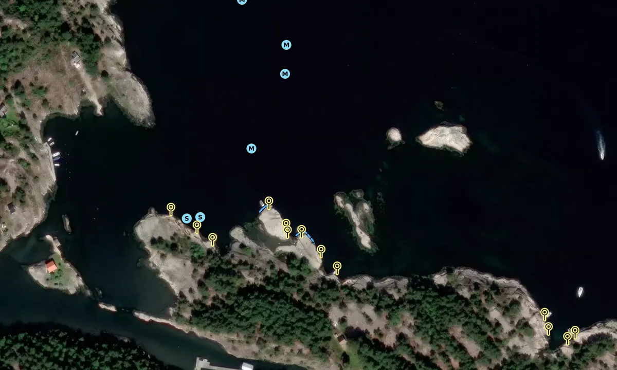
Bragdøya, østre: {"base": "no", "no": "Flott lun naturhavn som beskytter godt i mot b\u00f8lger i fra b\u00e5ter og ferjer.\r\nFlere bolter i fjell langs hele \u00f8stre siden.", "se": "Underbar skyddad naturhamn som ger bra skydd mot v\u00e5gor fr\u00e5n b\u00e5tar och f\u00e4rjor. Flera bergs\u00f6glor l\u00e4ngs hela \u00f6stra sidan.", "en": "Great sheltered natural harbour that provides good protection from waves caused by boats and ferries. Several bolts in the rock along the entire eastern side.", "da": "Flot lun naturhavn, som beskytter godt mod b\u00f8lger fra b\u00e5de og f\u00e6rger. Flere bolte i klippen langs hele \u00f8stsiden.", "fr": "Magnifique port naturel abrit\u00e9 qui offre une bonne protection contre les vagues des bateaux et des ferries. Plusieurs boulons dans la roche le long de tout le c\u00f4t\u00e9 est.", "de": "Toller, gesch\u00fctzter Naturhafen, der gut vor Wellen von Booten und F\u00e4hren gesch\u00fctzt ist. <br> Mehrere Bolzen im Felsen entlang der gesamten \u00f6stlichen Seite.", "es": "Hermoso y tranquilo puerto natural que ofrece una buena protecci\u00f3n contra las olas de barcos y ferris. Varios puntos de anclaje en la roca a lo largo de todo el lado este.", "it": "Splendido porto naturale riparato che offre una buona protezione contro le onde causate da barche e traghetti. Diversi bulloni sulla roccia lungo tutto il lato est.", "pt": "\u00d3timo porto natural abrigado, que protege bem contra as ondas de barcos e balsas.<br>V\u00e1rios parafusos nas rochas ao longo de todo o lado leste.", "nl": "Geweldig rustige natuurlijke haven die goed beschermt tegen golven van boten en veerboten. Meerdere bouten in de rotsen langs de hele oostzijde.", "pl": "\u0141adny zaciszny naturalny port, kt\u00f3ry dobrze chroni przed falami od \u0142odzi i prom\u00f3w. Kilka bolc\u00f3w w skale wzd\u0142u\u017c ca\u0142ej wschodniej strony.", "uk": "\u0427\u0443\u0434\u043e\u0432\u0430 \u043f\u0440\u0438\u0440\u043e\u0434\u043d\u0430 \u0433\u0430\u0432\u0430\u043d\u044c, \u044f\u043a\u0430 \u0434\u043e\u0431\u0440\u0435 \u0437\u0430\u0445\u0438\u0449\u0430\u0454 \u0432\u0456\u0434 \u0445\u0432\u0438\u043b\u044c \u0432\u0456\u0434 \u0447\u043e\u0432\u043d\u0456\u0432 \u0442\u0430 \u043f\u043e\u0440\u043e\u043c\u0456\u0432. \u041a\u0456\u043b\u044c\u043a\u0430 \u0430\u043d\u043a\u0435\u0440\u043d\u0438\u0445 \u0431\u043e\u043b\u0442\u0456\u0432 \u0443 \u0441\u043a\u0435\u043b\u044f\u0445 \u0432\u0437\u0434\u043e\u0432\u0436 \u0443\u0441\u044c\u043e\u0433\u043e \u0441\u0445\u0456\u0434\u043d\u043e\u0433\u043e \u0431\u043e\u043a\u0443.", "ro": "Port natural frumos \u0219i lini\u0219tit, care protejeaz\u0103 bine \u00eempotriva valurilor provenite de la b\u0103rci \u0219i feriboturi. Mai multe \u0219uruburi \u00een st\u00e2nc\u0103 de-a lungul \u00eentregii p\u0103r\u021bi estice.", "tr": "Feribot ve teknelerden gelen dalgalara kar\u015f\u0131 iyi koruma sa\u011flayan, g\u00fczel korunakl\u0131 do\u011fal liman. Do\u011fu taraf\u0131n\u0131n tamam\u0131 boyunca kayalara sabitlenmi\u015f bir\u00e7ok c\u0131vata bulunmaktad\u0131r.", "el": "\u038c\u03bc\u03bf\u03c1\u03c6\u03bf \u03c0\u03c1\u03bf\u03c3\u03c4\u03b1\u03c4\u03b5\u03c5\u03bc\u03ad\u03bd\u03bf \u03c6\u03c5\u03c3\u03b9\u03ba\u03cc \u03bb\u03b9\u03bc\u03ac\u03bd\u03b9 \u03c0\u03bf\u03c5 \u03c0\u03c1\u03bf\u03c3\u03c4\u03b1\u03c4\u03b5\u03cd\u03b5\u03b9 \u03ba\u03b1\u03bb\u03ac \u03b1\u03c0\u03cc \u03c4\u03b1 \u03ba\u03cd\u03bc\u03b1\u03c4\u03b1 \u03b1\u03c0\u03cc \u03c4\u03b1 \u03c0\u03bb\u03bf\u03af\u03b1 \u03ba\u03b1\u03b9 \u03c4\u03b1 \u03c6\u03ad\u03c1\u03b9. \u03a0\u03bf\u03bb\u03bb\u03ac \u03bc\u03c0\u03bf\u03c5\u03bb\u03cc\u03bd\u03b9\u03b1 \u03c3\u03b5 \u03cc\u03bb\u03b7 \u03c4\u03b7\u03bd \u03b1\u03bd\u03b1\u03c4\u03bf\u03bb\u03b9\u03ba\u03ae \u03c0\u03bb\u03b5\u03c5\u03c1\u03ac.", "cs": "P\u011bkn\u00fd klidn\u00fd p\u0159\u00edrodn\u00ed p\u0159\u00edstav, kter\u00fd dob\u0159e chr\u00e1n\u00ed p\u0159ed vlnami od lod\u00ed a trajekt\u016f. N\u011bkolik kotevn\u00edch \u0161roub\u016f ve sk\u00e1le pod\u00e9l cel\u00e9ho v\u00fdchodn\u00edho b\u0159ehu.", "hu": "Csod\u00e1latos nyugodt term\u00e9szetes kik\u00f6t\u0151, amely j\u00f3l v\u00e9d a haj\u00f3k \u00e9s komponok hull\u00e1mait\u00f3l. T\u00f6bb csavar r\u00f6gz\u00edtve a szikl\u00e1kba az eg\u00e9sz keleti oldalon.", "fi": "Upea suojainen luonnonsatama, joka suojaa hyvin veneiden ja lauttojen aalloilta. Useita pultteja kalliossa koko it\u00e4puolella.", "bg": "\u0427\u0443\u0434\u0435\u0441\u043d\u043e \u0443\u044e\u0442\u043d\u043e \u043f\u0440\u0438\u0440\u043e\u0434\u043d\u043e \u043f\u0440\u0438\u0441\u0442\u0430\u043d\u0438\u0449\u0435, \u043a\u043e\u0435\u0442\u043e \u0434\u043e\u0431\u0440\u0435 \u0437\u0430\u0449\u0438\u0442\u0430\u0432\u0430 \u043e\u0442 \u0432\u044a\u043b\u043d\u0438 \u043e\u0442 \u043b\u043e\u0434\u043a\u0438 \u0438 \u0444\u0435\u0440\u0438\u0431\u043e\u0442\u0438. \u041d\u044f\u043a\u043e\u043b\u043a\u043e \u0431\u043e\u043b\u0442\u0430 \u0432 \u0441\u043a\u0430\u043b\u0438\u0442\u0435 \u043f\u043e \u0446\u044f\u043b\u0430\u0442\u0430 \u0438\u0437\u0442\u043e\u0447\u043d\u0430 \u0441\u0442\u0440\u0430\u043d\u0430.", "sr": "\u041f\u0440\u0435\u043b\u0435\u043f\u0430 \u043f\u0440\u0438\u0440\u043e\u0434\u043d\u0430 \u043b\u0443\u043a\u0430 \u043a\u043e\u0458\u0430 \u043f\u0440\u0443\u0436\u0430 \u0434\u043e\u0431\u0440\u0443 \u0437\u0430\u0448\u0442\u0438\u0442\u0443 \u043e\u0434 \u0442\u0430\u043b\u0430\u0441\u0430 \u043e\u0434 \u0431\u0440\u043e\u0434\u043e\u0432\u0430 \u0438 \u0442\u0440\u0430\u0458\u0435\u043a\u0430\u0442\u0430. \u0412\u0438\u0448\u0435 \u043a\u043b\u0438\u043d\u043e\u0432\u0430 \u0443 \u0441\u0442\u0435\u043d\u0438 \u0434\u0443\u0436 \u0446\u0435\u043b\u0435 \u0438\u0441\u0442\u043e\u0447\u043d\u0435 \u0441\u0442\u0440\u0430\u043d\u0435.", "et": "Suurep\u00e4rane vaikne looduslik sadam, mis kaitseb h\u00e4sti paatide ja parvlaevade lainete eest. Kogu idak\u00fcljel on mitu kaljukinnitust.", "lv": "Lieliska dabas osta, kas labi aizsarg\u0101 pret vi\u013c\u0146iem no laiv\u0101m un pr\u0101mjiem. Gar visu austrumu pusi ir vair\u0101kas skr\u016bves klint\u012bs.", "lt": "Puikus ramus gamtos uostas, gerai apsaugantis nuo bang\u0173, sukelt\u0173 laiv\u0173 ir kelt\u0173. Keli var\u017etai \u012f uol\u0105 per vis\u0105 rytin\u0119 pus\u0119."}
Satelite image of Bragdøya, østre

📸 Upload a photo

Show off your photos and help others plan their journey to Bragdøya, østre.harbourmaps.com is created by the sailing community, in a collective effort to make cruising simpler and more fun. Uploading a photo takes less than a minutes and can be done from your phone, tablet or laptop.

📸 Upload a photo

Facilities

We don't have any data on available facilities in this harbour. If you know which facilities are available here, please update this site to help your fellow sailors. Update facilities.

Mooring

Options for mooring in this harbour: Towards land.

Updated on 4. Jul 2026. Update mooring.

Descriptions and reviews

Dan Mossmann says:

area

maritime qualities

description

Good depth all the way to the rocky shore. Good anchoring conditions.
Great hiking trails across the whole island, and a cozy summer kiosk on the north side.

[translated from Norwegian with AI]

1 x helpful | written on 4. Jul 2026 | updated_on 4. Jul 2026

Do you know this harbour? It's a huge help to other sailors if you add a short description or review of the harbour.

📜 Add description

Map of Bragdøya, østre

Facilities

We don't have any data on available facilities in this harbour. If you know which facilities are available here, please update this site to help your fellow sailors. Update facilities.

Mooring

Options for mooring in this harbour: Towards land.

Updated on 4. Jul 2026. Update mooring.

Wind protection

Protection next night

73 points

N E S W --> } } } } } } } } } } } } } } } } } } } } } } } } } } } } } } } } } } } } } } } } } } } } } } } } } } } } } } } } } } } } } } } } } } } } } } } } } } } } } } } } } } } } } } } } } } } } } } } } } } } } } } } } } } } } } } } } } } } } } } } } } } } } } } } } } } } } } } } } } } } } } } } } } } } } } } } } } } } } } } } } } } } } } } } } } } } } } } } } } } } } } } } } } } } } } } } } } } } } } } } } } } } } } } } } } } } } } } } } } } } } } } } } } } } } } } } } } } } } } } } } } } } } } } } } } } } } } } } } } } } } } } } } } } } } } } } } } } } } } } } } } } } } } } } } } } } } } } } } } } } } } } } } } } } } } } } } } } } } } } } } } } } } } } } } } } } } } } } } } } } } } } } } } } } } } } } } } } } } } } } } } } } } } } } } } } } } } } } } } } } } } } } } } } } } } } } } } } } } } } } } } } } } } } } } } } } } } } } } } } } } } } } } } } } } } } } } } } } } } } } } } } } } } } } } } } } } } } } } } } } } } } } } } } } } } } } } } } } } } } } } } } } } } } } } } } } } } } } } } } } } } } } } } } } } } } } } } } } } } } } } } } } } } } } } } } } } } } } } } } } } } } } } } } } } } } } } } } } } } } } } } } } } } } } } } } } } } } } } } } } } } } } } } } } } } } } } } } } } } } } } } } } } } } } } } } } } } } } } } } } } } } } } } } } } } } } } } } } } } } } } } } } } } } } } } } } } } } } } } } } } } } } } } } } } } } } } } } } } } } } } } } } } } } } } } } } } } } } } } } } } } } } } } } } } } } } } } } } } } } } } } } } } } } } } } } } } } } } } } } } } } } } } } } } } } } } } } } } } } } } } } } } } } } } } } } } } } } } } } } } } } } } } } } } } } } } } } } } } } } } } } } } } } } } } } } } } } } } } } } } } } } } } } } } } } } } } } } } } } } } } } } } } } } } } } } } } } } } } } } } } } } } } } } } } } } } } } } } } } } } } } } } } } } } } } } } } } } } } } } } } } } } } } } } } } } } } } } } } } } } } } } } } } } } } } } } } } } } } } } } } } } } } } } } } } } } } } } } } } } } } } } } } } } } } } } } } } } } } } } } } Next night 0:00 6:00 12:00 Søn 23 Aug 18:00 0:00 6:00 5m/s 1m/s

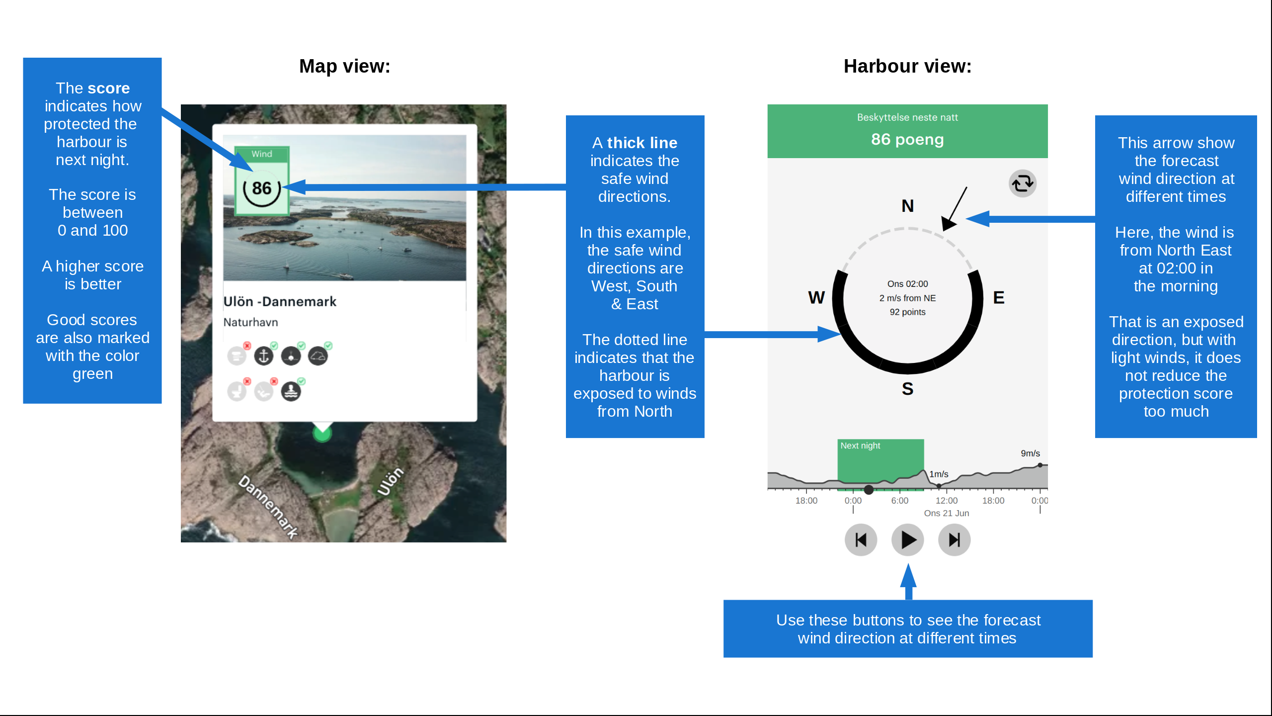
Want to know how the wind score works? Then you should read this explanation.

The wind forecasts come from yr.no (Norwegian Meteorological Institute), and was last updated 2 hours and 7 minutes ago (Saturday 22 August 06:28 PM). The next night score shows you the worst hour between 22:00 and 08:00 the next night. We recommend that you check multiple sources for wind forecasts. windy.com is a good website to show larger wind systems.

The safe wind directions for this harbour has been decided by an algorithm, based on how elevated the land around the harbour is. It's mostly correct, but sometimes the underlying data about elevation levels is not good enough to make correct decisions. It's a great help to other if you can validate or adjust the safe wind directions. You can see the data used by the algorithm to decide the safe wind directions by clicking here.

Last visits to Bragdøya, østre

Sat 08 Aug 2026

STORMFUGL V [MMSI: 258037120]

Fri 15 May 2026

ARTEMIS [MMSI: 219033052]

Thu 14 May 2026

ARTEMIS [MMSI: 219033052]

Tue 12 May 2026

ARTEMIS [MMSI: 219033052]

Tue 22 Jul 2025

ATLAS [MMSI: 244315799]

The visits are retrieved from AIS data. You can click to see all visiting ships to Bragdøya, østre, as well as statistics about the ships that visits

Add this harbour to a journey

Check in now

Choose a different date than today

Important: When you check in to a harbour, you add it to a journey on this website. You are not booking a place in the marina.

Contributors

Users that contributed to this page: Dan Mossmann

harbourmaps.com is updated by the boating community. When you add information, a review or pictures to this page you are listed here with the other contributors (we list your user-name, which can be your real name or a pseudonym).

Closest harbours to Bragdøya, østre

Filter by

Natural harbour
Marina
Safe wind next night

Order by

ABC
Popularity
Wind score next night

0 harbours

Show more harbours