

















Caol Scotnish

Natural harbour

favoritt

Region: United Kingdom (1318), Scotland (504), Argyll and Bute (151) and Lochgilphead (24)

Do you know this harbour?

harbourmaps.com is created by the sailing community, but there is no information on this page yet.

If you answer some quick questions or upload a photo, the harbour will be updated. It only takes a minute, with mostly yes/no questions and the page is designed for small mobile screens.

Your knowledge is highly valuable to other users who are searching for information about Caol Scotnish.

📜 Add info about the harbour

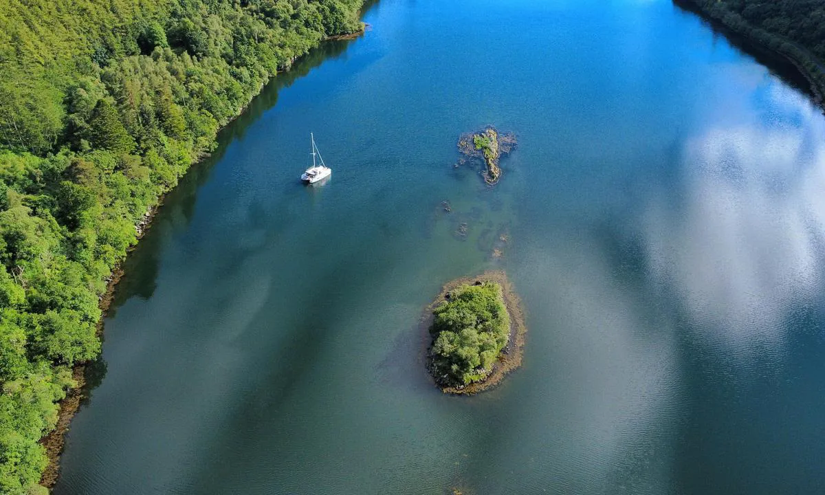
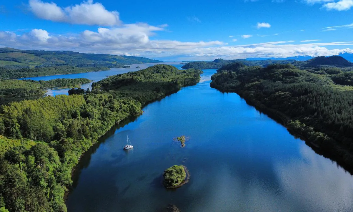
Caol Scotnish: {"base": "en", "no": "Dronevisning mot s\u00f8r gjennom den smale inngangen. Bruk av Antares-kart anbefales sterkt for \u00e5 unng\u00e5 skj\u00e6r.", "se": "Dr\u00f6narvy s\u00f6derut genom den smala ing\u00e5ngen. Anv\u00e4ndning av Antares sj\u00f6kort rekommenderas starkt f\u00f6r att undvika stenar.", "en": "Drone view looking south through the narrow entrance. Use of Antares charts strongly recommended to avoid rocks.", "da": "Droneudsigt mod syd gennem den smalle indgang. Brug af Antares-kort anbefales st\u00e6rkt for at undg\u00e5 klipper.", "fr": "Vue par drone vers le sud \u00e0 travers l'entr\u00e9e \u00e9troite. Utilisation des cartes Antares fortement recommand\u00e9e pour \u00e9viter les rochers.", "de": "Drohnenansicht nach S\u00fcden durch den engen Eingang. Die Verwendung von Antares-Karten wird dringend empfohlen, um Felsen zu vermeiden.", "es": "Vista de dron mirando hacia el sur a trav\u00e9s de la estrecha entrada. Se recomienda encarecidamente el uso de cartas de Antares para evitar rocas.", "it": "Vista con drone verso sud attraverso l'ingresso stretto. Uso delle carte Antares fortemente raccomandato per evitare le rocce.", "pt": "Vista a\u00e9rea de drone olhando para o sul atrav\u00e9s da entrada estreita. O uso das cartas Antares \u00e9 fortemente recomendado para evitar rochas.", "nl": "Dronebeeld kijkend naar het zuiden door de smalle ingang. Het gebruik van Antares-kaarten wordt sterk aanbevolen om rotsen te vermijden.", "pl": "Widok z drona na po\u0142udnie przez w\u0105skie wej\u015bcie. Zalecane jest stanowczo u\u017cywanie map Antares, aby unikn\u0105\u0107 ska\u0142.", "uk": "\u0412\u0438\u0434 \u0437 \u0434\u0440\u043e\u043d\u0430 \u043d\u0430 \u043f\u0456\u0432\u0434\u0435\u043d\u044c \u0447\u0435\u0440\u0435\u0437 \u0432\u0443\u0437\u044c\u043a\u0438\u0439 \u0432\u0445\u0456\u0434. \u0414\u043b\u044f \u0443\u043d\u0438\u043a\u043d\u0435\u043d\u043d\u044f \u043a\u0430\u043c\u0435\u043d\u0456\u0432 \u043d\u0430\u043f\u043e\u043b\u0435\u0433\u043b\u0438\u0432\u043e \u0440\u0435\u043a\u043e\u043c\u0435\u043d\u0434\u0443\u0454\u0442\u044c\u0441\u044f \u0432\u0438\u043a\u043e\u0440\u0438\u0441\u0442\u043e\u0432\u0443\u0432\u0430\u0442\u0438 \u043a\u0430\u0440\u0442\u0438 Antares.", "ro": "Vedere din dron\u0103 spre sud prin intrarea \u00eengust\u0103. Este recomandat\u0103 cu t\u0103rie utilizarea h\u0103r\u021bilor Antares pentru a evita st\u00e2ncile.", "tr": "Dron g\u00f6r\u00fcnt\u00fcs\u00fc, dar giri\u015fi g\u00fcneyden g\u00f6steriyor. Antares haritalar\u0131n\u0131n kullan\u0131m\u0131, kayal\u0131klardan ka\u00e7\u0131nmak i\u00e7in \u015fiddetle tavsiye edilir.", "el": "\u0398\u03ad\u03b1 \u03bc\u03b5 drone \u03ba\u03bf\u03b9\u03c4\u03ac\u03b6\u03bf\u03bd\u03c4\u03b1\u03c2 \u03bd\u03cc\u03c4\u03b9\u03b1 \u03bc\u03ad\u03c3\u03b1 \u03b1\u03c0\u03cc \u03c4\u03b7 \u03c3\u03c4\u03b5\u03bd\u03ae \u03b5\u03af\u03c3\u03bf\u03b4\u03bf. \u03a3\u03c5\u03bd\u03af\u03c3\u03c4\u03b1\u03c4\u03b1\u03b9 \u03ad\u03bd\u03c4\u03bf\u03bd\u03b1 \u03b7 \u03c7\u03c1\u03ae\u03c3\u03b7 \u03c4\u03c9\u03bd \u03c7\u03b1\u03c1\u03c4\u03ce\u03bd Antares \u03b3\u03b9\u03b1 \u03b1\u03c0\u03bf\u03c6\u03c5\u03b3\u03ae \u03b2\u03c1\u03ac\u03c7\u03c9\u03bd.", "cs": "Pohled z dronu sm\u011brem na jih \u00fazk\u00fdm vjezdem. D\u016frazn\u011b doporu\u010dujeme pou\u017e\u00edvat mapy Antares, abyste se vyhnuli skal\u00e1m.", "hu": "D\u00e9li ir\u00e1nyba n\u00e9z\u0151 dr\u00f3nfelv\u00e9tel a keskeny bej\u00e1raton \u00e1t. Az Antares t\u00e9rk\u00e9pek haszn\u00e1lata er\u0151sen aj\u00e1nlott a szikl\u00e1k elker\u00fcl\u00e9se \u00e9rdek\u00e9ben.", "fi": "Dronen\u00e4kym\u00e4 etel\u00e4\u00e4n kapean sis\u00e4\u00e4nk\u00e4ynnin kautta. Antares-karttojen k\u00e4ytt\u00f6 on eritt\u00e4in suositeltavaa kivien v\u00e4ltt\u00e4miseksi.", "bg": "\u0418\u0437\u0433\u043b\u0435\u0434 \u0441 \u0434\u0440\u043e\u043d \u043d\u0430 \u044e\u0433 \u043f\u0440\u0435\u0437 \u0442\u0435\u0441\u043d\u0438\u044f \u0432\u0445\u043e\u0434. \u041d\u0430\u0441\u0442\u043e\u044f\u0442\u0435\u043b\u043d\u043e \u0441\u0435 \u043f\u0440\u0435\u043f\u043e\u0440\u044a\u0447\u0432\u0430 \u0438\u0437\u043f\u043e\u043b\u0437\u0432\u0430\u043d\u0435\u0442\u043e \u043d\u0430 \u043a\u0430\u0440\u0442\u0438 Antares, \u0437\u0430 \u0434\u0430 \u0441\u0435 \u0438\u0437\u0431\u0435\u0433\u043d\u0430\u0442 \u0441\u043a\u0430\u043b\u0438.", "sr": "Pogled iz drona prema jugu kroz uski ulaz. Preporu\u010duje se upotreba Antaresovih karata kako bi se izbegle stene.", "et": "Droonivaade kitsast sisep\u00e4\u00e4sust l\u00f5una poole. Antarese kaartide kasutamine on tungivalt soovitatav, et v\u00e4ltida karisid.", "lv": "Drona skats uz dienvidiem caur \u0161auru ieeju. Ieteicams izmantot Antares kartes, lai izvair\u012btos no akme\u0146iem.", "lt": "Vaizdas i\u0161 drono, \u017ei\u016brint \u012f pietus per siaur\u0105 \u012fplauk\u0105. Rekomenduojama naudoti Antares j\u016brlapius, kad b\u016bt\u0173 i\u0161vengta uol\u0173."}
Caol Scotnish: {"base": "en", "no": "Dybde her ca 8m", "se": "Djup h\u00e4r cirka 8m", "en": "Depth here approx 8m", "da": "Dybde her ca. 8m", "fr": "Profondeur ici environ 8m", "de": "Tiefe hier ca. 8m", "es": "Profundidad aqu\u00ed aprox 8m", "it": "Profondit\u00e0 qui circa 8 m", "pt": "Profundidade aqui aprox 8m", "nl": "Diepte hier ongeveer 8m", "pl": "G\u0142\u0119boko\u015b\u0107 tutaj oko\u0142o 8m", "uk": "\u0413\u043b\u0438\u0431\u0438\u043d\u0430 \u0442\u0443\u0442 \u043f\u0440\u0438\u0431\u043b\u0438\u0437\u043d\u043e 8\u043c", "ro": "Ad\u00e2ncime aici aprox 8m", "tr": "Buradaki derinlik yakla\u015f\u0131k 8m", "el": "\u0392\u03ac\u03b8\u03bf\u03c2 \u03b5\u03b4\u03ce \u03c0\u03b5\u03c1\u03af\u03c0\u03bf\u03c5 8\u03bc", "cs": "Hloubka zde p\u0159ibli\u017en\u011b 8m", "hu": "A m\u00e9lys\u00e9g itt kb. 8m", "fi": "Syvyys t\u00e4\u00e4ll\u00e4 noin 8m", "bg": "\u0414\u044a\u043b\u0431\u043e\u0447\u0438\u043d\u0430 \u0442\u0443\u043a \u043f\u0440\u0438\u0431\u043b\u0438\u0437\u0438\u0442\u0435\u043b\u043d\u043e 8\u043c", "sr": "Dubina ovde pribli\u017eno 8m", "et": "S\u00fcgavus siin umbes 8m", "lv": "Dzi\u013cums \u0161eit aptuveni 8m", "lt": "Gylis \u010dia ~8m"}
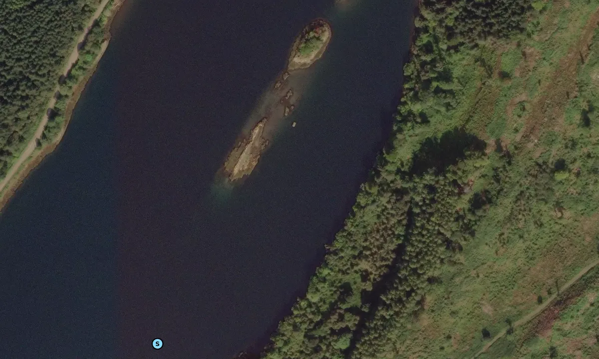
Satelite image of Caol Scotnish

📸 Upload a photo

Show off your photos and help others plan their journey to Caol Scotnish.harbourmaps.com is created by the sailing community, in a collective effort to make cruising simpler and more fun. Uploading a photo takes less than a minutes and can be done from your phone, tablet or laptop.

📸 Upload a photo

Facilities

We don't have any data on available facilities in this harbour. If you know which facilities are available here, please update this site to help your fellow sailors. Update facilities.

Mooring

We don't have any data on how to moor in this harbour. If you know how to moor here, please update this site to help your fellow sailors. Update mooring.

Descriptions and reviews

Do you know this harbour? It's a huge help to other sailors if you add a short description or review of the harbour.

📜 Add description

Map of Caol Scotnish

Facilities

We don't have any data on available facilities in this harbour. If you know which facilities are available here, please update this site to help your fellow sailors. Update facilities.

Mooring

We don't have any data on how to moor in this harbour. If you know how to moor here, please update this site to help your fellow sailors. Update mooring.

Wind protection

Protection next night

83 points

N E S W --> } } } } } } } } } } } } } } } } } } } } } } } } } } } } } } } } } } } } } } } } } } } } } } } } } } } } } } } } } } } } } } } } } } } } } } } } } } } } } } } } } } } } } } } } } } } } } } } } } } } } } } } } } } } } } } } } } } } } } } } } } } } } } } } } } } } } } } } } } } } } } } } } } } } } } } } } } } } } } } } } } } } } } } } } } } } } } } } } } } } } } } } } } } } } } } } } } } } } } } } } } } } } } } } } } } } } } } } } } } } } } } } } } } } } } } } } } } } } } } } } } } } } } } } } } } } } } } } } } } } } } } } } } } } } } } } } } } } } } } } } } } } } } } } } } } } } } } } } } } } } } } } } } } } } } } } } } } } } } } } } } } } } } } } } } } } } } } } } } } } } } } } } } } } } } } } } } } } } } } } } } } } } } } } } } } } } } } } } } } } } } } } } } } } } } } } } } } } } } } } } } } } } } } } } } } } } } } } } } } } } } } } } } } } } } } } } } } } } } } } } } } } } } } } } } } } } } } } } } } } } } } } } } } } } } } } } } } } } } } } } } } } } } } } } } } } } } } } } } } } } } } } } } } } } } } } } } } } } } } } } } } } } } } } } } } } } } } } } } } } } } } } } } } } } } } } } } } } } } } } } } } } } } } } } } } } } } } } } } } } } } } } } } } } } } } } } } } } } } } } } } } } } } } } } } } } } } } } } } } } } } } } } } } } } } } } } } } } } } } } } } } } } } } } } } } } } } } } } } } } } } } } } } } } } } } } } } } } } } } } } } } } } } } } } } } } } } } } } } } } } } } } } } } } } } } } } } } } } } } } } } } } } } } } } } } } } } } } } } } } } } } } } } } } } } } } } } } } } } } } } } } } } } } } } } } } } } } } } } } } } } } } } } } } } } } } } } } } } } } } } } } } } } } } } } } } } } } } } } } } } } } } } } } } } } } } } } } } } } } } } } } } } } } } } } } } } } } } } } } } } } } } } } } } } } } } } } } } } } } } } } } } } } } } } } } } } } } } } } } } } } } } } } } } } } } } } } } } } } } } } } } } } } } } } } } } } } } } } } } } } } } } } } } } } } } } } } } } } } } } } } } } } } } } } } } } } } } } } } } } } Next night 12:00 Fre 17 Jul 18:00 0:00 6:00 12:00 Lør 18 Jul 18:00 8m/s 5m/s

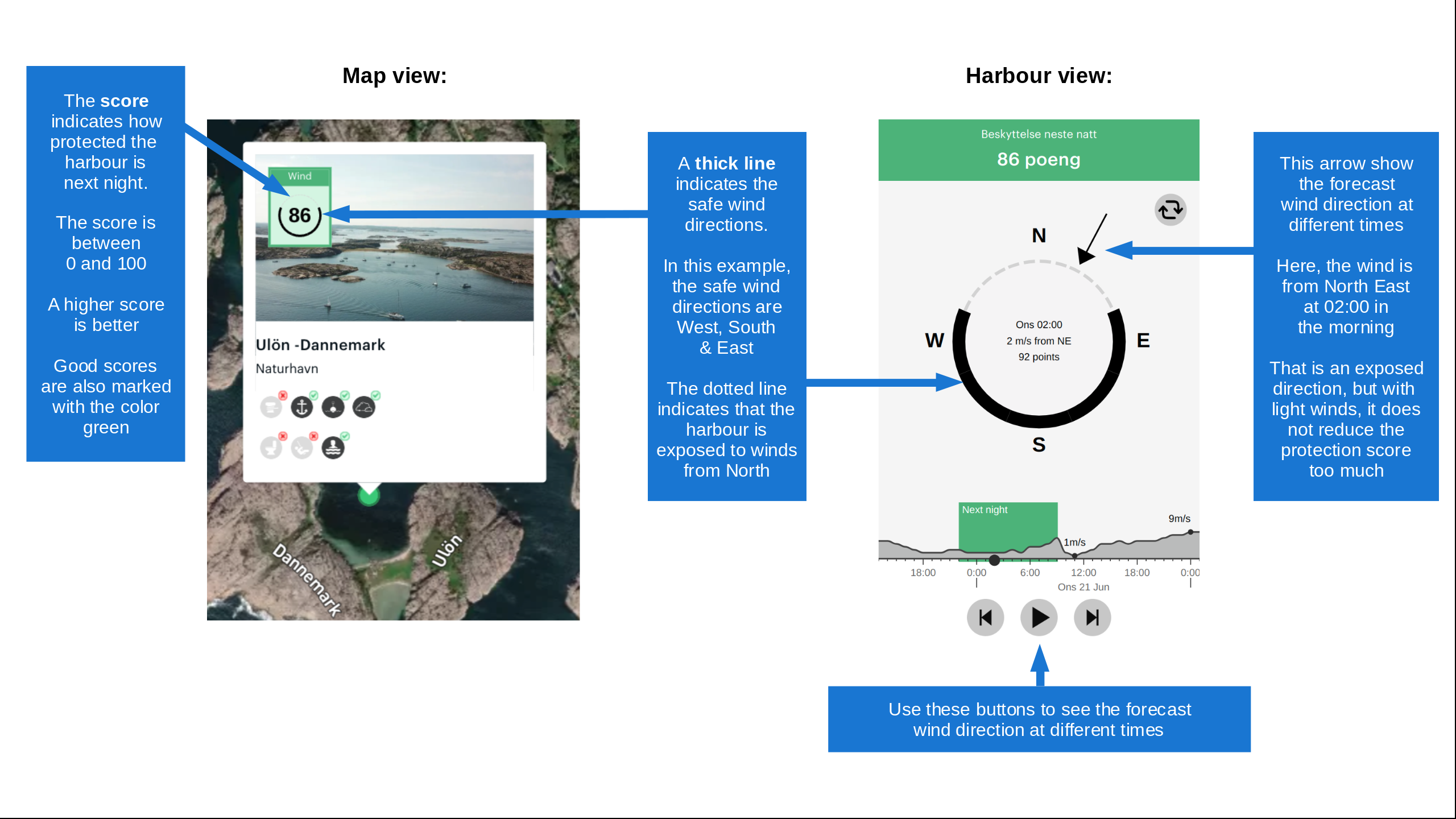
Want to know how the wind score works? Then you should read this explanation.

The wind forecasts come from yr.no (Norwegian Meteorological Institute), and was last updated 42 minutes ago (Friday 17 July 09:19 AM). The next night score shows you the worst hour between 22:00 and 08:00 the next night. We recommend that you check multiple sources for wind forecasts. windy.com is a good website to show larger wind systems.

The safe wind directions for this harbour has been decided by an algorithm, based on how elevated the land around the harbour is. It's mostly correct, but sometimes the underlying data about elevation levels is not good enough to make correct decisions. It's a great help to other if you can validate or adjust the safe wind directions. You can see the data used by the algorithm to decide the safe wind directions by clicking here.

Last visits to Caol Scotnish

Wed 25 Oct 2023

SV PEGASUS [MMSI: 232019201]

The visits are retrieved from AIS data. You can click to see all visiting ships to Caol Scotnish, as well as statistics about the ships that visits

Add this harbour to a journey

Check in now

Choose a different date than today

Important: When you check in to a harbour, you add it to a journey on this website. You are not booking a place in the marina.

Contributors

Users that contributed to this page: s/v Wild

harbourmaps.com is updated by the boating community. When you add information, a review or pictures to this page you are listed here with the other contributors (we list your user-name, which can be your real name or a pseudonym).

Closest harbours to Caol Scotnish

Filter by

Natural harbour
Marina
Safe wind next night

Order by

ABC
Popularity
Wind score next night

0 harbours

Show more harbours