























Grunnesund - Lillesand

Natural harbour

favoritt

Region: Norway (3534), Agder (295), Aust-Agder (152) and Lillesand (47)

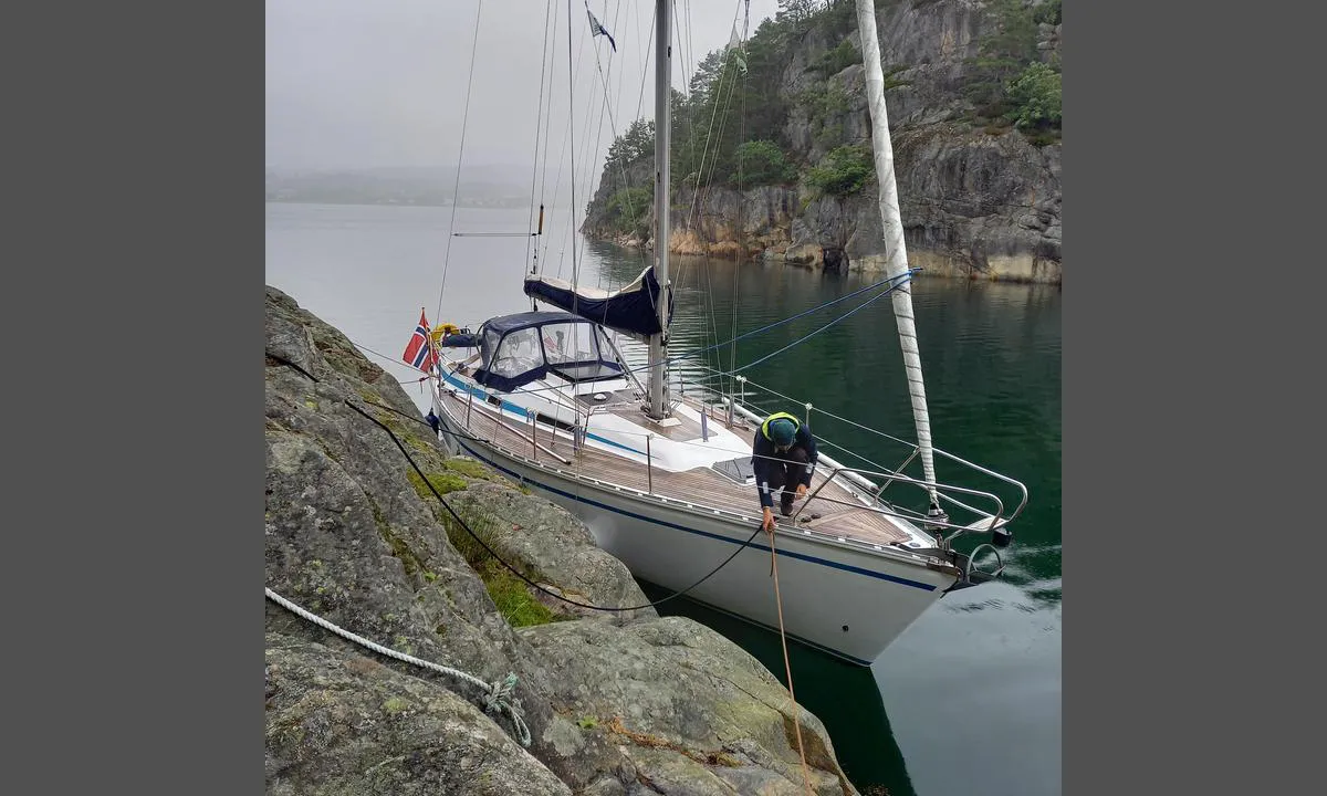
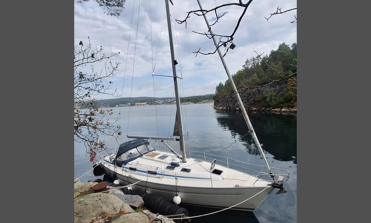
Grunnesund - Lillesand: {"base": "no", "no": "Longside mot Svin\u00f8ya.", "se": "L\u00e5ngsida mot Svin\u00f8ya.", "en": "Alongside Svin\u00f8ya.", "da": "Langskibs mod Svin\u00f8ya."}
Grunnesund - Lillesand: {"base": "no", "no": "Mot NV. Her bl\u00e5ser det kuling fra s\u00f8rvest og enkelte vindkast vrir inn i sundet.", "se": "Mot NV. H\u00e4r bl\u00e5ser det kuling fr\u00e5n sydv\u00e4st och enstaka vindkast vrider in i sundet.", "en": "Facing NW. Here it blows gale force from the southwest and occasional gusts twist into the strait.", "da": "Mod NV. Her bl\u00e6ser det kuling fra sydvest og enkelte vindst\u00f8d drejer ind i sundet."}
Grunnesund - Lillesand: {"base": "no", "no": "Bildekk festet til fjellsiden hjelper \u00e5 holde avstand til land. Dypt helt inn til land.", "se": "Bild\u00e4ck f\u00e4sta till bergssidan hj\u00e4lper att h\u00e5lla avst\u00e5nd till land. Djupt \u00e4nda in till land.", "en": "Tires attached to the mountainside help in keeping a distance from the shore. Deep right up to the shoreline.", "da": "Bild\u00e6k fastgjort til fjeldsiden hj\u00e6lper med at holde afstand til land. Dybde helt ind til land.", "fr": "Des pontons fix\u00e9s \u00e0 flanc de montagne aident \u00e0 garder une distance avec le rivage. Profond jusqu'au rivage.", "de": "An der Felswand befestigte Autoreifen helfen, Abstand zum Land zu halten. Tiefes Wasser direkt bis zum Ufer.", "es": "Cubiertas de neum\u00e1ticos fijadas a la ladera ayudan a mantener la distancia con la costa. Profundidad hasta la costa.", "it": "I ponti dei veicoli fissati al fianco della montagna aiutano a mantenere la distanza dalla terraferma. Profondo fino alla terraferma.", "pt": "Pneus fixados na encosta ajudam a manter a dist\u00e2ncia da terra. Fundo at\u00e9 a terra.", "nl": "Autobanden bevestigd aan de bergwand helpen afstand tot het land te houden. Diep helemaal tot aan het land.", "pl": "Opony przymocowane do zbocza pomagaj\u0105 utrzyma\u0107 odleg\u0142o\u015b\u0107 od l\u0105du. G\u0142\u0119boko ca\u0142kiem do l\u0105du.", "uk": "\u041f\u043d\u0435\u0432\u043c\u0430\u0442\u0438\u0447\u043d\u0456 \u0432\u0456\u0434\u0431\u043e\u0439\u043d\u0438\u043a\u0438, \u0437\u0430\u043a\u0440\u0456\u043f\u043b\u0435\u043d\u0456 \u043d\u0430 \u0441\u0445\u0438\u043b\u0456, \u0434\u043e\u043f\u043e\u043c\u0430\u0433\u0430\u044e\u0442\u044c \u0443\u0442\u0440\u0438\u043c\u0443\u0432\u0430\u0442\u0438 \u0432\u0456\u0434\u0441\u0442\u0430\u043d\u044c \u0434\u043e \u0431\u0435\u0440\u0435\u0433\u0430. \u0413\u043b\u0438\u0431\u0438\u043d\u0430 \u0437\u0431\u0435\u0440\u0456\u0433\u0430\u0454\u0442\u044c\u0441\u044f \u0430\u0436 \u0434\u043e \u0441\u0430\u043c\u043e\u0433\u043e \u0431\u0435\u0440\u0435\u0433\u0430.", "ro": "Pneuri de cauciuc ata\u0219ate de versantul muntelui ajut\u0103 la p\u0103strarea distan\u021bei fa\u021b\u0103 de \u021b\u0103rm. Ad\u00e2ncime p\u00e2n\u0103 aproape de \u021b\u0103rm.", "tr": "Da\u011fa sabitlenen resim g\u00fcvertesi, karaya olan mesafeyi korumaya yard\u0131mc\u0131 olur. Karaya tamamen yakla\u015ft\u0131r\u0131labilir.", "el": "\u03a4\u03b1 \u03b5\u03bb\u03b1\u03c3\u03c4\u03b9\u03ba\u03ac \u03c3\u03c5\u03bd\u03b4\u03b5\u03b4\u03b5\u03bc\u03ad\u03bd\u03b1 \u03c3\u03c4\u03b7\u03bd \u03c0\u03bb\u03b1\u03b3\u03b9\u03ac \u03c4\u03bf\u03c5 \u03b2\u03bf\u03c5\u03bd\u03bf\u03cd \u03b2\u03bf\u03b7\u03b8\u03bf\u03cd\u03bd \u03bd\u03b1 \u03ba\u03c1\u03b1\u03c4\u03b7\u03b8\u03b5\u03af \u03b7 \u03b1\u03c0\u03cc\u03c3\u03c4\u03b1\u03c3\u03b7 \u03b1\u03c0\u03cc \u03c4\u03b7\u03bd \u03b1\u03ba\u03c4\u03ae. \u0392\u03b1\u03b8\u03cd \u03bc\u03ad\u03c7\u03c1\u03b9 \u03c4\u03b7\u03bd \u03b1\u03ba\u03c4\u03ae.", "cs": "Pneumatiky p\u0159ipevn\u011bn\u00e9 k horsk\u00e9mu svahu pom\u00e1haj\u00ed udr\u017eovat odstup od pevniny. Hlubok\u00e9 a\u017e k sam\u00e9mu b\u0159ehu.", "hu": "Gumik\u00f6penyek a sziklafalhoz er\u0151s\u00edtve seg\u00edtenek t\u00e1vols\u00e1got tartani a sz\u00e1razf\u00f6ldt\u0151l. M\u00e9ly, eg\u00e9szen a partig.", "fi": "Renkaat kiinnitettyin\u00e4 kallionsein\u00e4m\u00e4\u00e4n auttavat pit\u00e4m\u00e4\u00e4n et\u00e4isyytt\u00e4 maihin. Syv\u00e4\u00e4 aivan rantaan saakka.", "bg": "\u0410\u0432\u0442\u043e\u043c\u043e\u0431\u0438\u043b\u043d\u0438 \u0433\u0443\u043c\u0438, \u0437\u0430\u043a\u0440\u0435\u043f\u0435\u043d\u0438 \u0437\u0430 \u0441\u043a\u0430\u043b\u0430\u0442\u0430, \u043f\u043e\u043c\u0430\u0433\u0430\u0442 \u0434\u0430 \u0441\u0435 \u043f\u043e\u0434\u0434\u044a\u0440\u0436\u0430 \u0440\u0430\u0437\u0441\u0442\u043e\u044f\u043d\u0438\u0435 \u0434\u043e \u0431\u0440\u0435\u0433\u0430. \u0414\u044a\u043b\u0431\u043e\u043a\u043e \u0434\u043e \u0431\u0440\u0435\u0433\u0430.", "sr": "\u0413\u0443\u043c\u0435\u043d\u0438 \u043e\u0434\u0431\u043e\u0458\u043d\u0438\u0446\u0438 \u043f\u0440\u0438\u0447\u0432\u0440\u0448\u045b\u0435\u043d\u0438 \u0437\u0430 \u0441\u0442\u0435\u043d\u0443 \u043f\u043e\u043c\u0430\u0436\u0443 \u0434\u0430 \u0441\u0435 \u043e\u0434\u0440\u0436\u0438 \u0440\u0430\u0437\u0434\u0430\u0459\u0438\u043d\u0430 \u0434\u043e \u043a\u043e\u043f\u043d\u0430. \u0414\u0443\u0431\u043e\u043a\u043e \u0441\u0432\u0435 \u0434\u043e \u043e\u0431\u0430\u043b\u0435.", "et": "Autokummid kinnitatud kaljuseinale aitavad hoida kaugust maast. Vesi on s\u00fcgav otse kaldani.", "lv": "Att\u0113lu kl\u0101ji piestiprin\u0101tas pie klints pal\u012bdz uztur\u0113t att\u0101lumu l\u012bdz zemei. Dzi\u013ci l\u012bdz pat zemei.", "lt": "<p>Padang\u0117s, pritvirtintos prie uolos \u0161laito, padeda i\u0161laikyti atstum\u0105 iki kranto. Gilu iki pat kranto.</p>"}
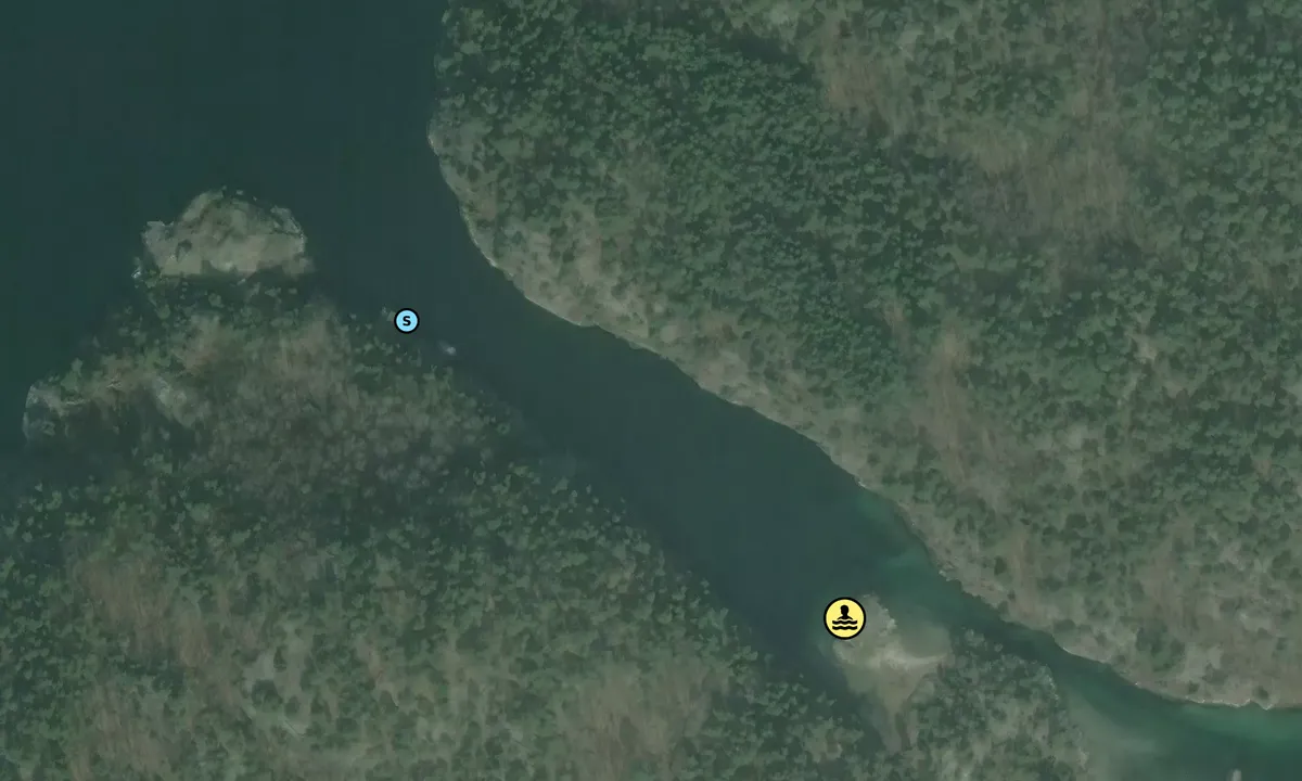
Satelite image of Grunnesund - Lillesand

📸 Upload a photo

Show off your photos and help others plan their journey to Grunnesund - Lillesand.harbourmaps.com is created by the sailing community, in a collective effort to make cruising simpler and more fun. Uploading a photo takes less than a minutes and can be done from your phone, tablet or laptop.

📸 Upload a photo

Facilities

Available facilities: Swimming area.

Updated on 29. Jul 2026. Update facilities.

Mooring

Options for mooring in this harbour: Towards land.

Updated on 29. Jul 2026. Update mooring.

Descriptions and reviews

Woj says:

area

maritime qualities

description

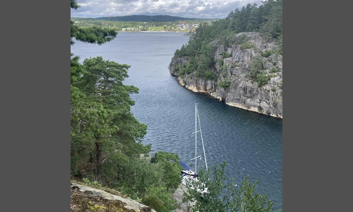
Good space and depth up to the mountainside, there are some tires that help maintain distance from the shore. Poor anchoring due to a cable (haven't tried it myself). Good protection from W and SW wind. There can be some waves when the cabin residents are in a hurry to take the boat to Lillesand. Nice hiking opportunities in the terrain on the island. Can be recommended.

[translated from Norwegian with AI]

1 x helpful | written on 29. Jul 2026

SY Luna says:

area

maritime qualities

description

Good natural harbor when it is rough outside. High forested hills on both sides provide shelter. There are bolts along the south side and on the peninsula towards the southeast. Tires have also been placed against the mountain in a couple of places for mooring barges. Be aware of cables if you plan to anchor. The approach from the east is only 1.5 m deep, while from the west there is good depth. The disadvantages of the harbor are that the sun disappears early and some speedboats causing waves.

During a southwesterly gale, we experienced some turbulence inside the strait.

[translated from Norwegian with AI]

2 x helpful | written on 6. Jul 2024 | updated_on 7. Jul 2024

Do you know this harbour? It's a huge help to other sailors if you add a short description or review of the harbour.

📜 Add description

Map of Grunnesund - Lillesand

Facilities

Available facilities: Swimming area.

Updated on 29. Jul 2026. Update facilities.

Mooring

Options for mooring in this harbour: Towards land.

Updated on 29. Jul 2026. Update mooring.

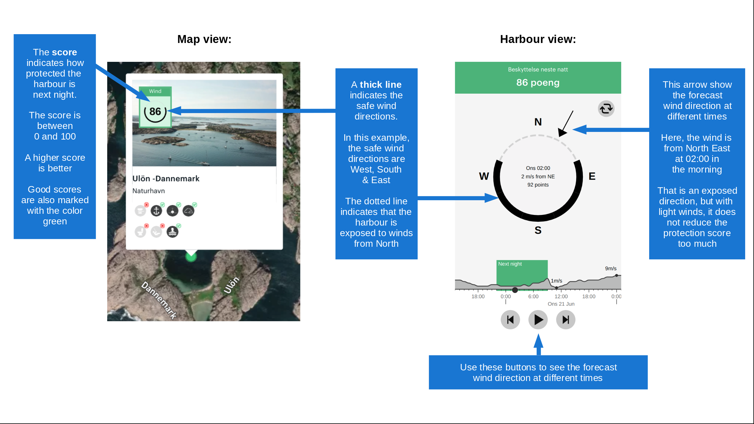
Wind protection

Protection next night

83 points

N E S W --> } } } } } } } } } } } } } } } } } } } } } } } } } } } } } } } } } } } } } } } } } } } } } } } } } } } } } } } } } } } } } } } } } } } } } } } } } } } } } } } } } } } } } } } } } } } } } } } } } } } } } } } } } } } } } } } } } } } } } } } } } } } } } } } } } } } } } } } } } } } } } } } } } } } } } } } } } } } } } } } } } } } } } } } } } } } } } } } } } } } } } } } } } } } } } } } } } } } } } } } } } } } } } } } } } } } } } } } } } } } } } } } } } } } } } } } } } } } } } } } } } } } } } } } } } } } } } } } } } } } } } } } } } } } } } } } } } } } } } } } } } } } } } } } } } } } } } } } } } } } } } } } } } } } } } } } } } } } } } } } } } } } } } } } } } } } } } } } } } } } } } } } } } } } } } } } } } } } } } } } } } } } } } } } } } } } } } } } } } } } } } } } } } } } } } } } } } } } } } } } } } } } } } } } } } } } } } } } } } } } } } } } } } } } } } } } } } } } } } } } } } } } } } } } } } } } } } } } } } } } } } } } } } } } } } } } } } } } } } } } } } } } } } } } } } } } } } } } } } } } } } } } } } } } } } } } } } } } } } } } } } } } } } } } } } } } } } } } } } } } } } } } } } } } } } } } } } } } } } } } } } } } } } } } } } } } } } } } } } } } } } } } } } } } } } } } } } } } } } } } } } } } } } } } } } } } } } } } } } } } } } } } } } } } } } } } } } } } } } } } } } } } } } } } } } } } } } } } } } } } } } } } } } } } } } } } } } } } } } } } } } } } } } } } } } } } } } } } } } } } } } } } } } } } } } } } } } } } } } } } } } } } } } } } } } } } } } } } } } } } } } } } } } } } } } } } } } } } } } } } } } } } } } } } } } } } } } } } } } } } } } } } } } } } } } } } } } } } } } } } } } } } } } } } } } } } } } } } } } } } } } } } } } } } } } } } } } } } } } } } } } } } } } } } } } } } } } } } } } } } } } } } } } } } } } } } } } } } } } } } } } } } } } } } } } } } } } } } } } } } } } } } } } } } } } } } } } } } } } } } } } } } } } } } } } } } } } } } } } } } } } } } } } } } } } } } } } } } } } } } } } } } } } } } } } } } } } } } } } } } } Next night 12:00 Tir 01 Sep 18:00 0:00 6:00 12:00 Ons 02 Sep 18:00 5m/s 1m/s

Want to know how the wind score works? Then you should read this explanation.

The wind forecasts come from yr.no (Norwegian Meteorological Institute), and was last updated 2 hours and 4 minutes ago (Tuesday 01 September 07:40 AM). The next night score shows you the worst hour between 22:00 and 08:00 the next night. We recommend that you check multiple sources for wind forecasts. windy.com is a good website to show larger wind systems.

The safe directions for this harbour was added at 7. Jul 2024. Click here to edit.

Last visits to Grunnesund - Lillesand

Sun 01 Oct 2023

RS UNG AGDER 1 [MMSI: 257026480]

Fri 04 Aug 2023

CHOICETTA [MMSI: 258098830]

Sat 29 Jul 2023

GURLI MEREHE [MMSI: 219031985]

The visits are retrieved from AIS data. You can click to see all visiting ships to Grunnesund - Lillesand, as well as statistics about the ships that visits

Add this harbour to a journey

Check in now

Choose a different date than today

Important: When you check in to a harbour, you add it to a journey on this website. You are not booking a place in the marina.

Contributors

Users that contributed to this page: SY Luna and Woj

harbourmaps.com is updated by the boating community. When you add information, a review or pictures to this page you are listed here with the other contributors (we list your user-name, which can be your real name or a pseudonym).

Closest harbours to Grunnesund - Lillesand

Filter by

Natural harbour
Marina
Safe wind next night

Order by

ABC
Popularity
Wind score next night

0 harbours

Show more harbours