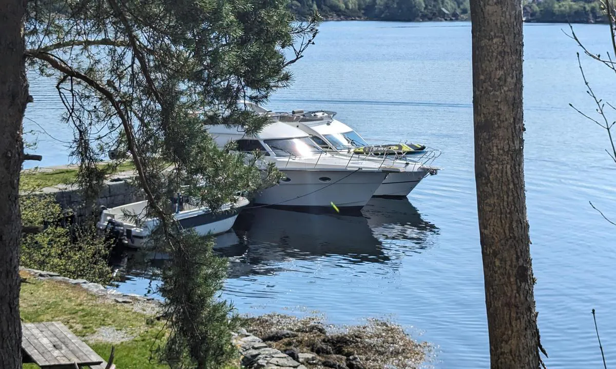
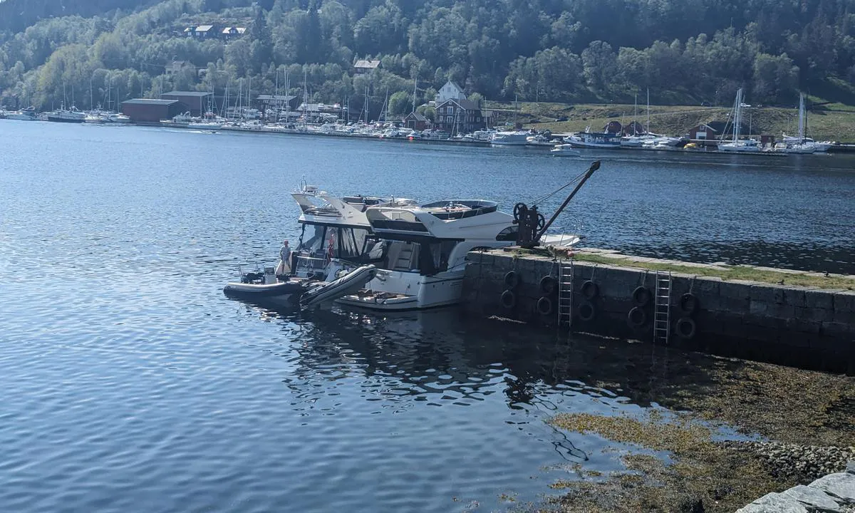
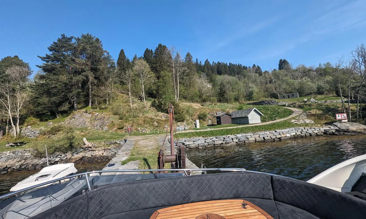
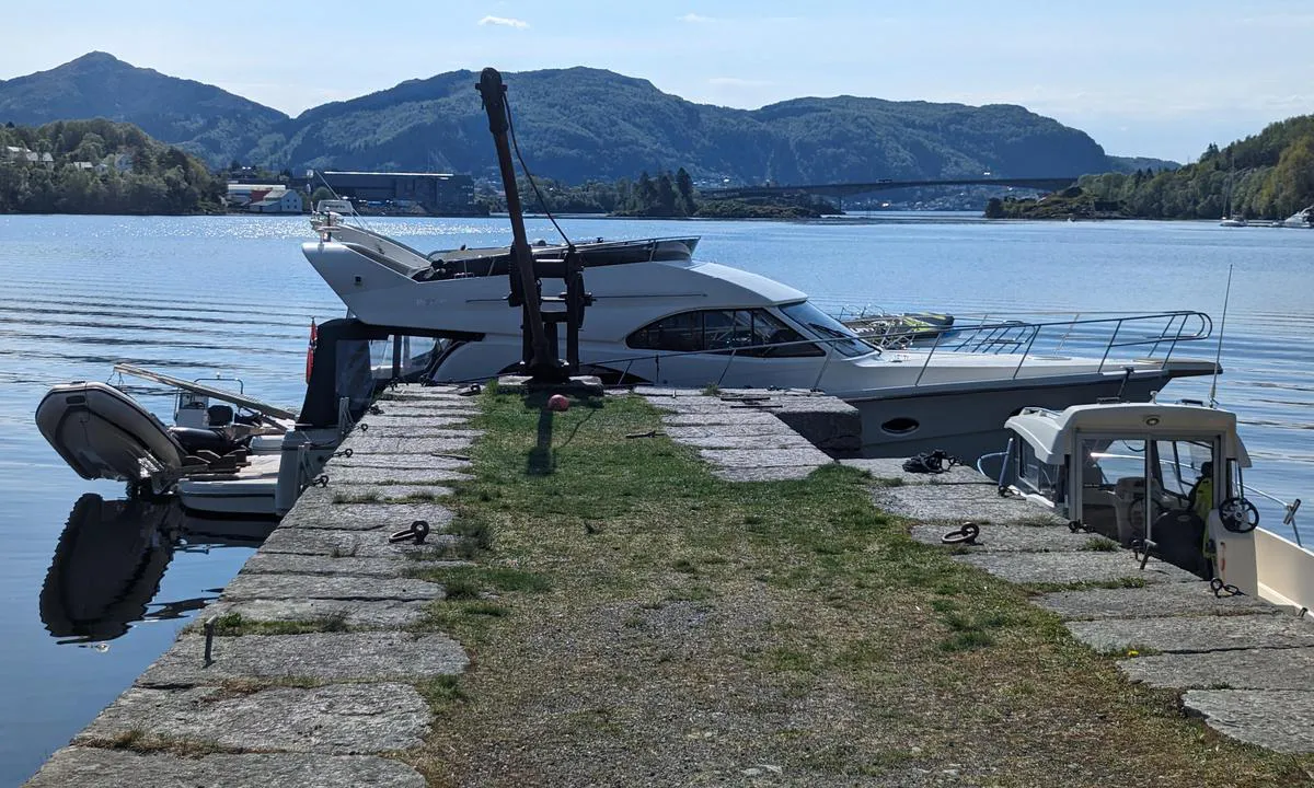
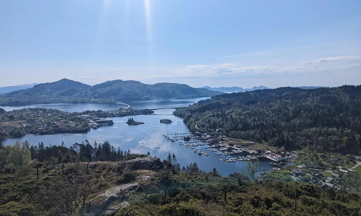
Håøya

Natural harbour

favoritt

Region: Norway (3433), Vestland (602), Hordaland (396), Alver (25) and Litlebergen (2)

Håøya
Håøya
Håøya
Håøya: {"base": "no", "no": "Kaien er ganske h\u00f8y, men p\u00e5 vestsiden hvor den minste b\u00e5ten ligger, er det trapp.", "se": "Kajen \u00e4r ganska h\u00f6g, men p\u00e5 v\u00e4stsidan d\u00e4r den minsta b\u00e5ten ligger, finns det en trappa.", "en": "The quay is quite high, but on the west side where the smallest boat is, there is a ladder.", "da": "Kajen er temmelig h\u00f8j, men p\u00e5 vestsiden hvor den mindste b\u00e5d ligger, er der trappe.", "fr": "Le quai est assez haut, mais du c\u00f4t\u00e9 ouest o\u00f9 se trouve le plus petit bateau, il y a un escalier.", "de": "Der Kai ist ziemlich hoch, aber auf der Westseite, wo das kleinste Boot liegt, gibt es eine Treppe.", "es": "El muelle es bastante alto, pero en el lado occidental donde est\u00e1 el barco m\u00e1s peque\u00f1o, hay una escalera.", "it": "Il molo \u00e8 piuttosto alto, ma sul lato ovest dove si trova la barca pi\u00f9 piccola, c'\u00e8 una scala.", "pt": "O cais \u00e9 bastante alto, mas no lado oeste onde fica o menor barco, h\u00e1 uma escada.", "nl": "De kade is vrij hoog, maar aan de westkant waar de kleinste boot ligt, is er een trap.", "pl": "Nabrze\u017ce jest do\u015b\u0107 wysokie, ale po zachodniej stronie, gdzie cumuje najmniejsza \u0142\u00f3d\u017a, znajduje si\u0119 schody.", "uk": "\u041f\u0456\u0440\u0441 \u0434\u043e\u0441\u0438\u0442\u044c \u0432\u0438\u0441\u043e\u043a\u0438\u0439, \u0430\u043b\u0435 \u043d\u0430 \u0437\u0430\u0445\u0456\u0434\u043d\u0456\u0439 \u0441\u0442\u043e\u0440\u043e\u043d\u0456, \u0434\u0435 \u0441\u0442\u043e\u0457\u0442\u044c \u043d\u0430\u0439\u043c\u0435\u043d\u0448\u0438\u0439 \u0447\u043e\u0432\u0435\u043d, \u0454 \u0441\u0445\u043e\u0434\u0438.", "ro": "Cheiul este destul de \u00eenalt, dar pe partea de vest unde se afl\u0103 cea mai mic\u0103 barc\u0103, exist\u0103 o scar\u0103.", "tr": "R\u0131ht\u0131m olduk\u00e7a y\u00fcksek, ancak en k\u00fc\u00e7\u00fck teknenin bulundu\u011fu bat\u0131 taraf\u0131nda bir merdiven vard\u0131r.", "el": "\u0397 \u03c0\u03c1\u03bf\u03b2\u03bb\u03ae\u03c4\u03b1 \u03b5\u03af\u03bd\u03b1\u03b9 \u03b1\u03c1\u03ba\u03b5\u03c4\u03ac \u03c8\u03b7\u03bb\u03ae, \u03b1\u03bb\u03bb\u03ac \u03c3\u03c4\u03b7 \u03b4\u03c5\u03c4\u03b9\u03ba\u03ae \u03c0\u03bb\u03b5\u03c5\u03c1\u03ac, \u03cc\u03c0\u03bf\u03c5 \u03b2\u03c1\u03af\u03c3\u03ba\u03b5\u03c4\u03b1\u03b9 \u03c4\u03bf \u03bc\u03b9\u03ba\u03c1\u03cc\u03c4\u03b5\u03c1\u03bf \u03c3\u03ba\u03ac\u03c6\u03bf\u03c2, \u03c5\u03c0\u03ac\u03c1\u03c7\u03b5\u03b9 \u03c3\u03ba\u03ac\u03bb\u03b1.", "cs": "Molo je docela vysok\u00e9, ale na z\u00e1padn\u00ed stran\u011b, kde le\u017e\u00ed nejmen\u0161\u00ed lo\u010f, jsou schody.", "hu": "A rakpart meglehet\u0151sen magas, de a nyugati oldalon, ahol a legkisebb haj\u00f3 fekszik, van l\u00e9pcs\u0151.", "fi": "Laituri on melko korkea, mutta l\u00e4nsipuolella, miss\u00e4 pienin vene sijaitsee, on portaat.", "bg": "\u041a\u0435\u044f\u0442 \u0435 \u0434\u043e\u0441\u0442\u0430 \u0432\u0438\u0441\u043e\u043a, \u043d\u043e \u043e\u0442 \u0437\u0430\u043f\u0430\u0434\u043d\u0430\u0442\u0430 \u0441\u0442\u0440\u0430\u043d\u0430, \u043a\u044a\u0434\u0435\u0442\u043e \u043b\u0435\u0436\u0438 \u043d\u0430\u0439-\u043c\u0430\u043b\u043a\u0430\u0442\u0430 \u043b\u043e\u0434\u043a\u0430, \u0438\u043c\u0430 \u0441\u0442\u044a\u043b\u0431\u0430.", "sr": "Keja je prili\u010dno visoka, ali na zapadnoj strani gde je najmanji brod, nalazi se stepeni\u0161te.", "et": "Kaile on \u00fcsna k\u00f5rge, kuid l\u00e4\u00e4nek\u00fcljel, kus v\u00e4ikseim paat asub, on trepp.", "lv": "Piest\u0101tne ir diezgan augsta, bet rietumu pus\u0113, kur atrodas maz\u0101kais ku\u0123is, ir k\u0101pnes.", "lt": "Prieplauka yra gana auk\u0161t\u0105, ta\u010diau vakarin\u0117je pus\u0117je, kur stovi ma\u017eiausias laivas, yra laiptai."}
Håøya: {"base": "no", "no": "Spor fra krigen finnes.", "se": "Sp\u00e5r fr\u00e5n kriget finns.", "en": "Traces from the war can be found.", "da": "Spor fra krigen findes.", "fr": "Des traces de la guerre se trouvent.", "de": "Spuren vom Krieg sind vorhanden.", "es": "Se encuentran rastros de la guerra.", "it": "Tracce della guerra sono presenti.", "pt": "Vest\u00edgios da guerra est\u00e3o presentes.", "nl": "Sporen uit de oorlog zijn te vinden.", "pl": "\u015alady z czas\u00f3w wojny s\u0105 widoczne.", "uk": "\u0421\u043b\u0456\u0434\u0438 \u0432\u0456\u0439\u043d\u0438 \u0437\u043d\u0430\u0439\u0434\u0435\u043d\u0456.", "ro": "Urme ale r\u0103zboiului sunt prezente.", "tr": "Sava\u015f\u0131n izleri var.", "el": "\u03a5\u03c0\u03ac\u03c1\u03c7\u03bf\u03c5\u03bd \u03af\u03c7\u03bd\u03b7 \u03b1\u03c0\u03cc \u03c4\u03bf\u03bd \u03c0\u03cc\u03bb\u03b5\u03bc\u03bf.", "cs": "Stopy po v\u00e1lce jsou k nalezen\u00ed.", "hu": "A h\u00e1bor\u00fa nyomai megtal\u00e1lhat\u00f3ak.", "fi": "Sodan j\u00e4ljet n\u00e4kyviss\u00e4.", "bg": "\u0421\u043b\u0435\u0434\u0438 \u043e\u0442 \u0432\u043e\u0439\u043d\u0430\u0442\u0430 \u0441\u044a\u0449\u0435\u0441\u0442\u0432\u0443\u0432\u0430\u0442.", "sr": "Tragovi rata su prisutni.", "et": "S\u00f5jaj\u00e4lgi leidub.", "lv": "Kara p\u0113das ir atrodamas.", "lt": "Karo p\u0117dsakai matomi."}
Håøya: {"base": "no", "no": "Meget bra utsikt fra toppen", "se": "Mycket bra utsikt fr\u00e5n toppen", "en": "Very good view from the top", "da": "Meget god udsigt fra toppen", "fr": "Tr\u00e8s belle vue depuis le sommet", "de": "Sehr guter Ausblick von der Spitze", "es": "Muy buena vista desde la cima", "it": "Vista molto buona dalla cima", "pt": "Muito boa vista do topo", "nl": "Zeer goed uitzicht vanaf de top", "pl": "Bardzo dobry widok ze szczytu", "uk": "\u0414\u0443\u0436\u0435 \u0433\u0430\u0440\u043d\u0438\u0439 \u0432\u0438\u0434 \u0437 \u0432\u0435\u0440\u0448\u0438\u043d\u0438", "ro": "Vedere foarte bun\u0103 de pe v\u00e2rf", "tr": "\u00dcstten \u00e7ok iyi manzara", "el": "\u03a0\u03bf\u03bb\u03cd \u03ba\u03b1\u03bb\u03ae \u03b8\u03ad\u03b1 \u03b1\u03c0\u03cc \u03c4\u03b7\u03bd \u03ba\u03bf\u03c1\u03c5\u03c6\u03ae", "cs": "Velmi dobr\u00fd v\u00fdhled z vrcholu", "hu": "Nagyon j\u00f3 kil\u00e1t\u00e1s a cs\u00facsr\u00f3l", "fi": "Erinomainen n\u00e4kym\u00e4 huipulta", "bg": "\u041c\u043d\u043e\u0433\u043e \u0434\u043e\u0431\u044a\u0440 \u0438\u0437\u0433\u043b\u0435\u0434 \u043e\u0442 \u0432\u044a\u0440\u0445\u0430", "sr": "Veoma lep pogled sa vrha", "et": "V\u00e4ga hea vaade tipust", "lv": "\u013boti labs skats no virsotnes", "lt": "Labai geras vaizdas nuo vir\u0161\u016bn\u0117s"}
Satelite image of Håøya

📸 Upload a photo

Show off your photos and help others plan their journey to Håøya.harbourmaps.com is created by the sailing community, in a collective effort to make cruising simpler and more fun. Uploading a photo takes less than a minutes and can be done from your phone, tablet or laptop.

📸 Upload a photo

Facilities

Available facilities: Toilet, Playground, Swimming area.

Updated on 19. Oct 2024. Update facilities.

Mooring

Options for mooring in this harbour: To pier/wharf, Towards land.

Updated on 19. Oct 2024. Update mooring.

Descriptions and reviews

Do you know this harbour? It's a huge help to other sailors if you add a short description or review of the harbour.
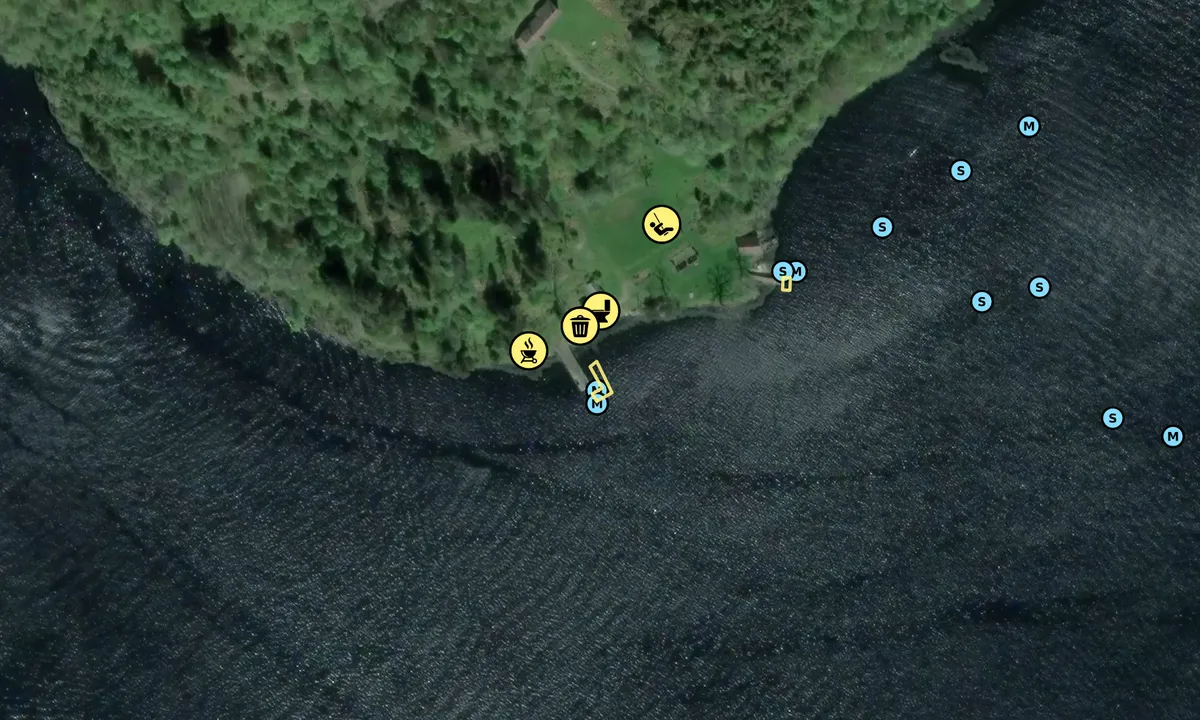
📜 Add description

Map of Håøya

Facilities

Available facilities: Toilet, Playground, Swimming area.

Updated on 19. Oct 2024. Update facilities.

Mooring

Options for mooring in this harbour: To pier/wharf, Towards land.

Updated on 19. Oct 2024. Update mooring.

Wind protection

Protection next night

88 points

N E S W --> } } } } } } } } } } } } } } } } } } } } } } } } } } } } } } } } } } } } } } } } } } } } } } } } } } } } } } } } } } } } } } } } } } } } } } } } } } } } } } } } } } } } } } } } } } } } } } } } } } } } } } } } } } } } } } } } } } } } } } } } } } } } } } } } } } } } } } } } } } } } } } } } } } } } } } } } } } } } } } } } } } } } } } } } } } } } } } } } } } } } } } } } } } } } } } } } } } } } } } } } } } } } } } } } } } } } } } } } } } } } } } } } } } } } } } } } } } } } } } } } } } } } } } } } } } } } } } } } } } } } } } } } } } } } } } } } } } } } } } } } } } } } } } } } } } } } } } } } } } } } } } } } } } } } } } } } } } } } } } } } } } } } } } } } } } } } } } } } } } } } } } } } } } } } } } } } } } } } } } } } } } } } } } } } } } } } } } } } } } } } } } } } } } } } } } } } } } } } } } } } } } } } } } } } } } } } } } } } } } } } } } } } } } } } } } } } } } } } } } } } } } } } } } } } } } } } } } } } } } } } } } } } } } } } } } } } } } } } } } } } } } } } } } } } } } } } } } } } } } } } } } } } } } } } } } } } } } } } } } } } } } } } } } } } } } } } } } } } } } } } } } } } } } } } } } } } } } } } } } } } } } } } } } } } } } } } } } } } } } } } } } } } } } } } } } } } } } } } } } } } } } } } } } } } } } } } } } } } } } } } } } } } } } } } } } } } } } } } } } } } } } } } } } } } } } } } } } } } } } } } } } } } } } } } } } } } } } } } } } } } } } } } } } } } } } } } } } } } } } } } } } } } } } } } } } } } } } } } } } } } } } } } } } } } } } } } } } } } } } } } } } } } } } } } } } } } } } } } } } } } } } } } } } } } } } } } } } } } } } } } } } } } } } } } } } } } } } } } } } } } } } } } } } } } } } } } } } } } } } } } } } } } } } } } } } } } } } } } } } } } } } } } } } } } } } } } } } } } } } } } } } } } } } } } } } } } } } } } } } } } } } } } } } } } } } } } } } } } } } } } } } } } } } } } } } } } } } } } } } } } } } } } } } } } } } } } } } } } } } } } } } } } } } } } } } } } } } } } } } } } } } } } } } } } } } } } } } } } } } } } Next night 18:00 0:00 6:00 12:00 Søn 01 Feb 18:00 0:00 3m/s 1m/s

Want to know how the wind score works? Then you should read this explanation.

The wind forecasts come from yr.no (Norwegian Meteorological Institute), and was last updated 1 hour and 30 minutes ago (Saturday 31 January 01:26 PM). The next night score shows you the worst hour between 22:00 and 08:00 the next night. We recommend that you check multiple sources for wind forecasts. windy.com is a good website to show larger wind systems.

The safe wind directions for this harbour has been decided by an algorithm, based on how elevated the land around the harbour is. It's mostly correct, but sometimes the underlying data about elevation levels is not good enough to make correct decisions. It's a great help to other if you can validate or adjust the safe wind directions. You can see the data used by the algorithm to decide the safe wind directions by clicking here.

Last visits to Håøya

Wed 27 Aug 2025

SEEADLER [MMSI: 211303460]

Wed 23 Jul 2025

MARIE [MMSI: 258144970]

Wed 18 Jun 2025

DJ 4511 [MMSI: 211333770]

Sat 19 Apr 2025

MIRIAM [MMSI: 257122070]

Mon 12 Aug 2024

LUCY [MMSI: 211453610]

The visits are retrieved from AIS data. You can click to see all visiting ships to Håøya, as well as statistics about the ships that visits

Add this harbour to a journey

Check in now

Choose a different date than today

Important: When you check in to a harbour, you add it to a journey on this website. You are not booking a place in the marina.

Contributors

Users that contributed to this page: StianN and Roy Eide

harbourmaps.com is updated by the boating community. When you add information, a review or pictures to this page you are listed here with the other contributors (we list your user-name, which can be your real name or a pseudonym).

Closest harbours to Håøya

Filter by

Natural harbour
Marina
Safe wind next night

Order by

ABC
Popularity
Wind score next night

0 harbours

Show more harbours