Haringvreter East Marina

Marina

favoritt

Region: Netherlands (574), Zeeland (88) and Veere (13)

Het eiland Haringvreter. Met gele omranding de oostelijke jachthaven.
(Foto van pzc.nl).
{"base": "nl", "no": "Veere sett fra \u00f8ya Haringvreter. <br> (Bilde fra nos.nl)", "se": "Veere sedd fr\u00e5n \u00f6n Haringvreter.<br>(Foto fr\u00e5n nos.nl)", "en": "Veere seen from Haringvreter island.<br>(Photo by nos.nl)", "da": "Veere set fra \u00f8en Haringvreter.<br>(Foto fra nos.nl)", "fr": "Veere vu depuis l'\u00eele Haringvreter. <br>(Photo de nos.nl)", "de": "Veere gesehen von der Insel Haringvreter.<br />(Foto von nos.nl)", "es": "Veere vista desde la isla Haringvreter.<br>(Foto de nos.nl)", "it": "Veere vista dall'isola Haringvreter.<br>(Foto di nos.nl)", "pt": "Veere vista da ilha Haringvreter. (Foto de nos.nl)", "nl": "Veere gezien vanuit eiland Haringvreter.\r\n(Foto van nos.nl)", "pl": "Widok na Veere z wyspy Haringvreter. <br> (Zdj\u0119cie z nos.nl)", "uk": "\u0412\u0435\u0440\u0435, \u0432\u0438\u0434 \u0437 \u043e\u0441\u0442\u0440\u043e\u0432\u0430 \u0425\u0430\u0440\u0456\u043d\u0433\u0432\u0440\u0435\u0442\u0435\u0440. <br> (\u0424\u043e\u0442\u043e \u0432\u0456\u0434 nos.nl)", "ro": "Veere v\u0103zut\u0103 din insula Haringvreter.<br>(Foto de pe nos.nl)", "tr": "Haringvreter Adas\u0131'ndan g\u00f6r\u00fclen Veere. (nos.nl'den foto\u011fraf)", "el": "\u0397 \u03b8\u03ad\u03b1 \u03c4\u03bf\u03c5 Veere \u03b1\u03c0\u03cc \u03c4\u03bf \u03bd\u03b7\u03c3\u03af Haringvreter.<br>(\u03a6\u03c9\u03c4\u03bf\u03b3\u03c1\u03b1\u03c6\u03af\u03b1 \u03b1\u03c0\u03cc \u03c4\u03bf nos.nl)", "cs": "Veere vid\u011bno z ostrova Haringvreter. <br>(Foto od nos.nl)", "hu": "Veere a Haringvreter szigetr\u0151l n\u00e9zve. (K\u00e9p a nos.nl-t\u0151l)", "fi": "Veere n\u00e4htyn\u00e4 Haringvreterin saarelta.<br />(Kuva nos.nl:st\u00e4)", "bg": "\u0412\u0435\u0435\u0440\u0435, \u0432\u0438\u0434\u044f\u043d\u043e \u043e\u0442 \u043e\u0441\u0442\u0440\u043e\u0432 \u0425\u0430\u0440\u0438\u043d\u0433\u0432\u0440\u0435\u0442\u0435\u0440. (\u0421\u043d\u0438\u043c\u043a\u0430 \u043e\u0442 nos.nl)", "sr": "\u0412\u0435\u0440\u0435 \u0432\u0438\u0452\u0435\u043d\u043e \u0441\u0430 \u043e\u0441\u0442\u0440\u0432\u0430 \u0425\u0430\u0440\u0438\u043d\u0433\u0444\u0440\u0435\u0442\u0435\u0440. <br>(\u0424\u043e\u0442\u043e: nos.nl)", "et": "Vaade Veerele Haringvreteri saarelt.<br/>(Foto nos.nl)", "lv": "Veere skat\u012bts no Haringvreter salas. (Foto no nos.nl)", "lt": "Veere matoma i\u0161 Haringvreter salos.<br />(Nuotrauka i\u0161 nos.nl)"}
Satelite image of Haringvreter East Marina

📸 Upload a photo

Show off your photos and help others plan their journey to Haringvreter East Marina.harbourmaps.com is created by the sailing community, in a collective effort to make cruising simpler and more fun. Uploading a photo takes less than a minutes and can be done from your phone, tablet or laptop.

📸 Upload a photo

Facilities

Available facilities: Toilet.

Updated on 5. Jan 2026. Update facilities.

Mooring

Options for mooring in this harbour: To pier/wharf.

Updated on 5. Jan 2026. Update mooring.

Contact information

website: scheldestromen.nl/onze-taken/veerse-meer

phone: Add phone number

email: Add email

Descriptions and reviews

seaDjon says:

description

From "https://www.zeeland.com/nl-nl/visit/325_nl/haringvreter":
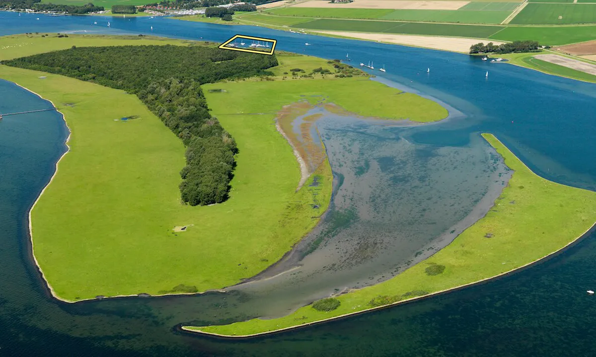
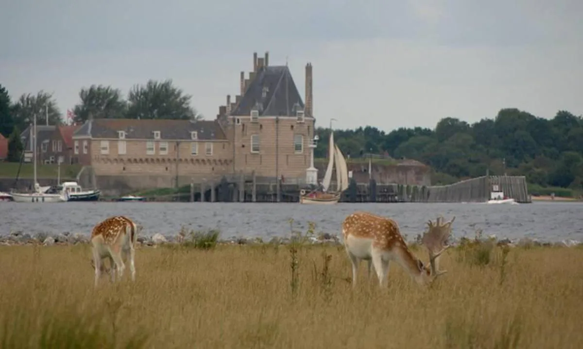
Haringvreters. This was what seals used to be called by fishermen. Seals would rest on what was then a sandbank in the sea. After the closure of the Veerse Meer in 1961, the sandbank dried up and a forest was planted there. Now, 'De Haringvreter' is an open and expansive area where many birds overwinter. Take a boat trip with an excursion to the island 'de Haringvreter' and don't forget your binoculars!
The most remarkable sight on De Haringvreter are the fallow deer, which have been grazing there for the past ten years.

[translated from Dutch with AI]

1 x helpful | written on 5. Jan 2026

Do you know this harbour? It's a huge help to other sailors if you add a short description or review of the harbour.

📜 Add description

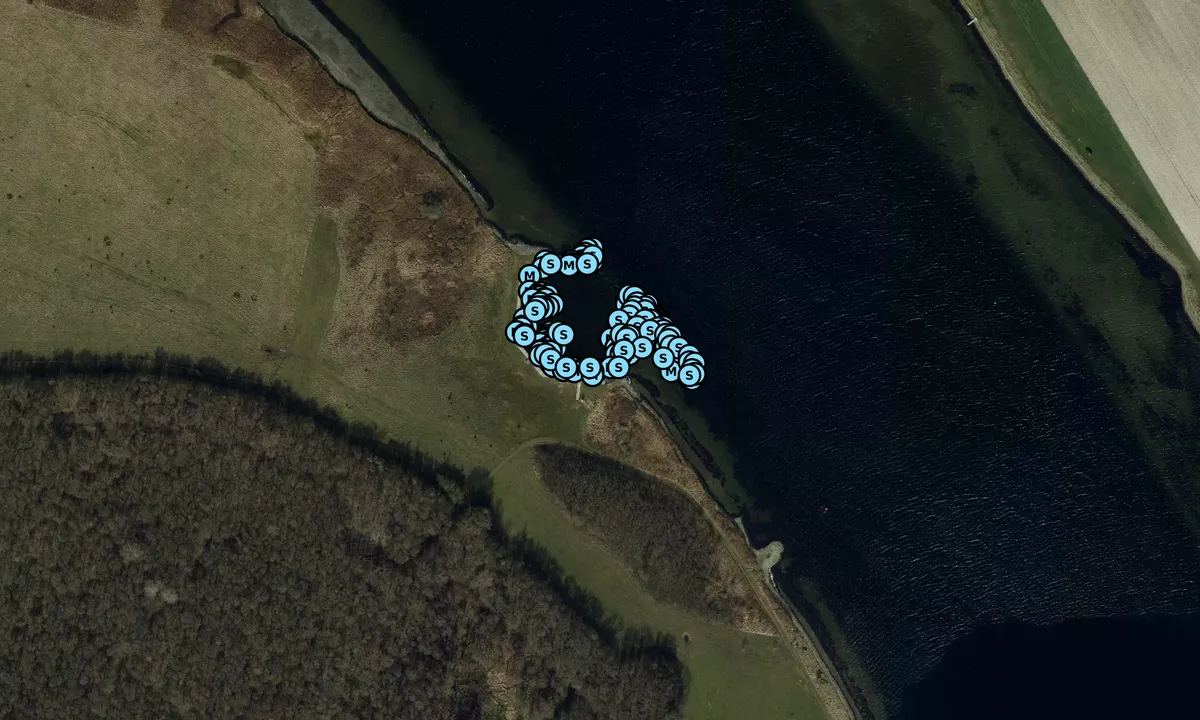
Map of Haringvreter East Marina

Facilities

Available facilities: Toilet.

Updated on 5. Jan 2026. Update facilities.

Mooring

Options for mooring in this harbour: To pier/wharf.

Updated on 5. Jan 2026. Update mooring.

Wind protection

Protection next night

89 points

N E S W --> } } } } } } } } } } } } } } } } } } } } } } } } } } } } } } } } } } } } } } } } } } } } } } } } } } } } } } } } } } } } } } } } } } } } } } } } } } } } } } } } } } } } } } } } } } } } } } } } } } } } } } } } } } } } } } } } } } } } } } } } } } } } } } } } } } } } } } } } } } } } } } } } } } } } } } } } } } } } } } } } } } } } } } } } } } } } } } } } } } } } } } } } } } } } } } } } } } } } } } } } } } } } } } } } } } } } } } } } } } } } } } } } } } } } } } } } } } } } } } } } } } } } } } } } } } } } } } } } } } } } } } } } } } } } } } } } } } } } } } } } } } } } } } } } } } } } } } } } } } } } } } } } } } } } } } } } } } } } } } } } } } } } } } } } } } } } } } } } } } } } } } } } } } } } } } } } } } } } } } } } } } } } } } } } } } } } } } } } } } } } } } } } } } } } } } } } } } } } } } } } } } } } } } } } } } } } } } } } } } } } } } } } } } } } } } } } } } } } } } } } } } } } } } } } } } } } } } } } } } } } } } } } } } } } } } } } } } } } } } } } } } } } } } } } } } } } } } } } } } } } } } } } } } } } } } } } } } } } } } } } } } } } } } } } } } } } } } } } } } } } } } } } } } } } } } } } } } } } } } } } } } } } } } } } } } } } } } } } } } } } } } } } } } } } } } } } } } } } } } } } } } } } } } } } } } } } } } } } } } } } } } } } } } } } } } } } } } } } } } } } } } } } } } } } } } } } } } } } } } } } } } } } } } } } } } } } } } } } } } } } } } } } } } } } } } } } } } } } } } } } } } } } } } } } } } } } } } } } } } } } } } } } } } } } } } } } } } } } } } } } } } } } } } } } } } } } } } } } } } } } } } } } } } } } } } } } } } } } } } } } } } } } } } } } } } } } } } } } } } } } } } } } } } } } } } } } } } } } } } } } } } } } } } } } } } } } } } } } } } } } } } } } } } } } } } } } } } } } } } } } } } } } } } } } } } } } } } } } } } } } } } } } } } } } } } } } } } } } } } } } } } } } } } } } } } } } } } } } } } } } } } } } } } } } } } } } } } } } } } } } } } } } } } } } } } } } } } } } } } } } } } } } } } } } } } } } } } } } } } } } Next night 6:00 12:00 Lør 07 Feb 18:00 0:00 6:00 12:00 Søn 08 Feb 18:00 6m/s 2m/s

Want to know how the wind score works? Then you should read this explanation.

The wind forecasts come from yr.no (Norwegian Meteorological Institute), and was last updated 1 hour and 23 minutes ago (Saturday 07 February 06:16 AM). The next night score shows you the worst hour between 22:00 and 08:00 the next night. We recommend that you check multiple sources for wind forecasts. windy.com is a good website to show larger wind systems.

The safe directions for this harbour was added at 20. Jan 2026. Click here to edit.

Last visits to Haringvreter East Marina

Wed 01 Oct 2025

MIRIANDA [MMSI: 244040992]

Mon 29 Sep 2025

VRIJBUITER [MMSI: 244650232]

Sat 27 Sep 2025

HARDEBOLLE [MMSI: 244030389]

ZOLAH [MMSI: 205514110]

Sat 20 Sep 2025

MIRIANDA [MMSI: 244040992]

The visits are retrieved from AIS data. You can click to see all visiting ships to Haringvreter East Marina, as well as statistics about the ships that visits

Add this harbour to a journey

Check in now

Choose a different date than today

Important: When you check in to a harbour, you add it to a journey on this website. You are not booking a place in the marina.

Contributors

Users that contributed to this page: seaDjon

harbourmaps.com is updated by the boating community. When you add information, a review or pictures to this page you are listed here with the other contributors (we list your user-name, which can be your real name or a pseudonym).

Closest harbours to Haringvreter East Marina

Filter by

Natural harbour
Marina
Safe wind next night

Order by

ABC
Popularity
Wind score next night

0 harbours

Show more harbours