Hellemobotn

Marina

favoritt

Region: Norway (3278), Nordland (645), Hamarøy (27) and Musken (1)

{"base": "no", "no": "Hellemobotn (eller Hellmobotn) i Tysfjord.", "se": "Hellemobotn (eller Hellmobotn) i Tysfjord.", "en": "Hellemobotn (or Hellmobotn) in Tysfjord.", "da": "Hellemobotn (eller Hellmobotn) i Tysfjord."}
Hellemobotn: {"base": "no", "no": "Ytterst p\u00e5 indre bygge. God dybde (10m), ogs\u00e5 lenger inn.", "se": "Ytterst p\u00e5 inre brygga. Bra djup (10m), \u00e4ven l\u00e4ngre in.", "en": "Outer end of inner quay. Good depth (10m), also further in.", "da": "Yderst p\u00e5 den indre mole. God dybde (10m), ogs\u00e5 l\u00e6ngere inde."}
Satelite image of Hellemobotn

📸 Upload a photo

Show off your photos and help others plan their journey to Hellemobotn.harbourmaps.com is created by the sailing community, in a collective effort to make cruising simpler and more fun. Uploading a photo takes less than a minutes and can be done from your phone, tablet or laptop.

📸 Upload a photo

Facilities

Available facilities: Fresh water.

Updated on 1. Jul 2021. Update facilities.

Mooring

Options for mooring in this harbour: To pier/wharf.

Updated on 1. Jul 2021. Update mooring.

Contact information

website: Add website

phone: +47 95774422

email: Add email

Descriptions and reviews

O2 says:

area

maritime qualities

description

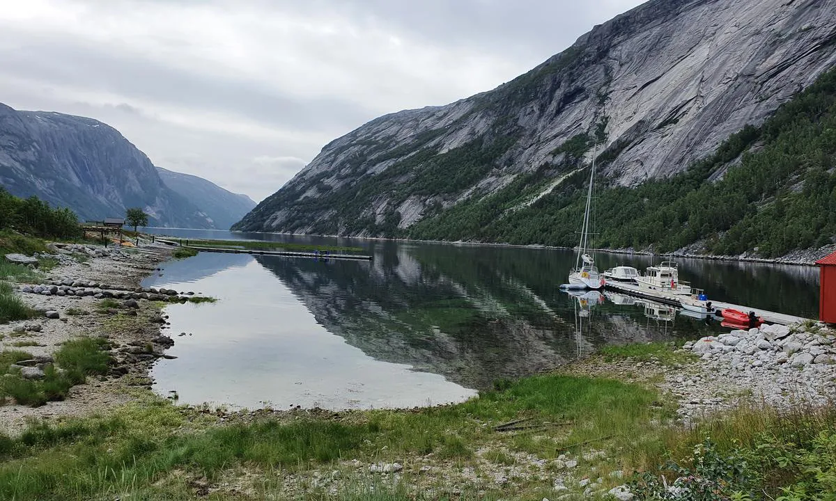
A great destination by boat, and it's a 'must' to bring hiking boots and walk the 9 kilometers (and 1000 meters of elevation) up to the national border. Good trail and lots of beautiful nature.

Contact Hans Mikkelsen at 95774422 to arrange a spot at the innermost dock.

Note that as of July 2024, only Telenor has mobile coverage here. Up in the mountains by the border, there is no coverage.

[translated from Norwegian with AI]

1 x helpful | written on 4. Jul 2024 | updated_on 4. Jul 2024

Ingo W says:

description

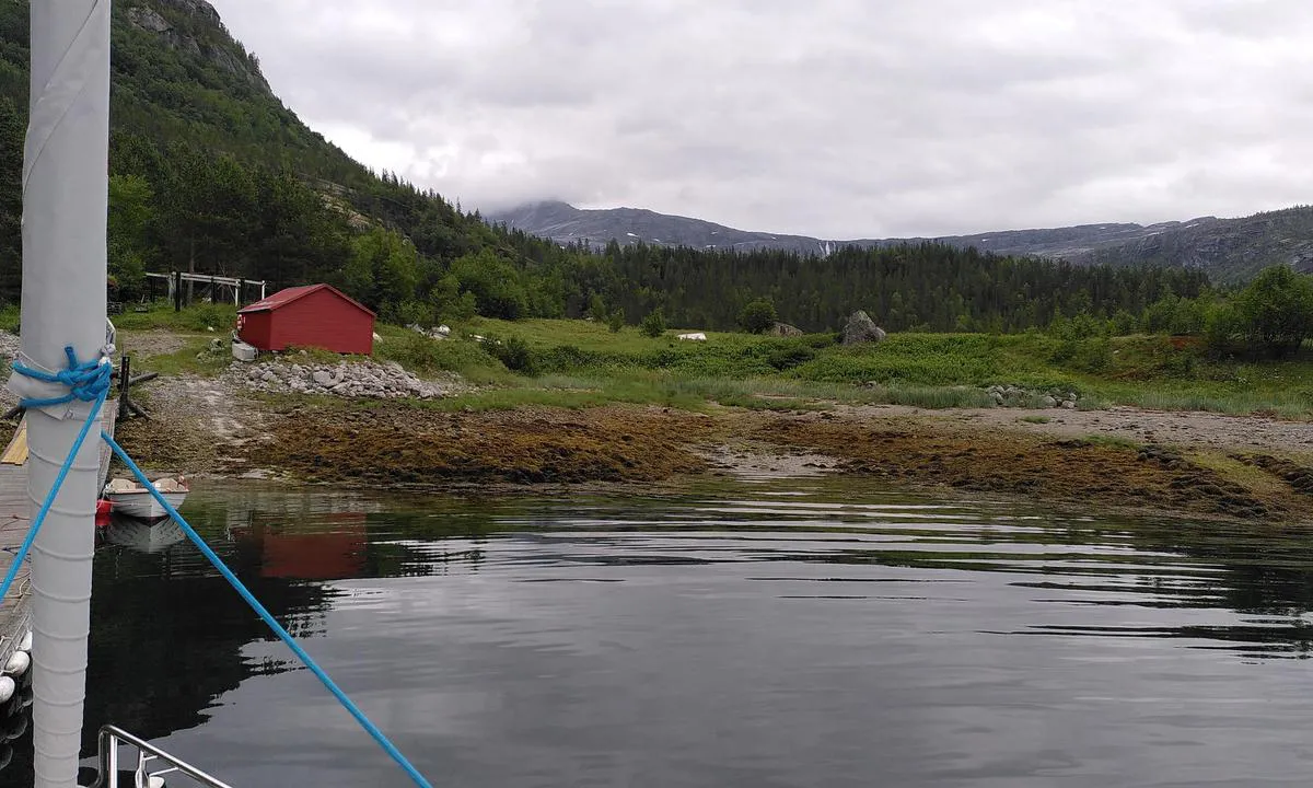
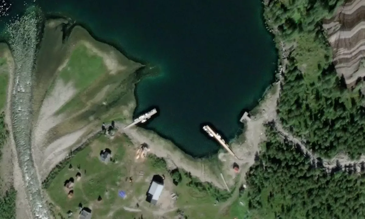
Approach and maritime conditions: Two private floating docks, deep inside. Ask for permission to dock there, it might cost a bit.
Berthing: Floating dock alongside
The area: Cabin village.
Additionally, a starting point for a well-prepared and T-marked trail to the Swedish border, 500 meters elevation, 9 km one way. Then you have walked across Norway :)

[translated from Norwegian with AI]

1 x helpful | written on 1. Jul 2021

Do you know this harbour? It's a huge help to other sailors if you add a short description or review of the harbour.

📜 Add description

Map of Hellemobotn

Facilities

Available facilities: Fresh water.

Updated on 1. Jul 2021. Update facilities.

Mooring

Options for mooring in this harbour: To pier/wharf.

Updated on 1. Jul 2021. Update mooring.

Wind protection

Protection next night

96 points

N E S W --> } } } } } } } } } } } } } } } } } } } } } } } } } } } } } } } } } } } } } } } } } } } } } } } } } } } } } } } } } } } } } } } } } } } } } } } } } } } } } } } } } } } } } } } } } } } } } } } } } } } } } } } } } } } } } } } } } } } } } } } } } } } } } } } } } } } } } } } } } } } } } } } } } } } } } } } } } } } } } } } } } } } } } } } } } } } } } } } } } } } } } } } } } } } } } } } } } } } } } } } } } } } } } } } } } } } } } } } } } } } } } } } } } } } } } } } } } } } } } } } } } } } } } } } } } } } } } } } } } } } } } } } } } } } } } } } } } } } } } } } } } } } } } } } } } } } } } } } } } } } } } } } } } } } } } } } } } } } } } } } } } } } } } } } } } } } } } } } } } } } } } } } } } } } } } } } } } } } } } } } } } } } } } } } } } } } } } } } } } } } } } } } } } } } } } } } } } } } } } } } } } } } } } } } } } } } } } } } } } } } } } } } } } } } } } } } } } } } } } } } } } } } } } } } } } } } } } } } } } } } } } } } } } } } } } } } } } } } } } } } } } } } } } } } } } } } } } } } } } } } } } } } } } } } } } } } } } } } } } } } } } } } } } } } } } } } } } } } } } } } } } } } } } } } } } } } } } } } } } } } } } } } } } } } } } } } } } } } } } } } } } } } } } } } } } } } } } } } } } } } } } } } } } } } } } } } } } } } } } } } } } } } } } } } } } } } } } } } } } } } } } } } } } } } } } } } } } } } } } } } } } } } } } } } } } } } } } } } } } } } } } } } } } } } } } } } } } } } } } } } } } } } } } } } } } } } } } } } } } } } } } } } } } } } } } } } } } } } } } } } } } } } } } } } } } } } } } } } } } } } } } } } } } } } } } } } } } } } } } } } } } } } } } } } } } } } } } } } } } } } } } } } } } } } } } } } } } } } } } } } } } } } } } } } } } } } } } } } } } } } } } } } } } } } } } } } } } } } } } } } } } } } } } } } } } } } } } } } } } } } } } } } } } } } } } } } } } } } } } } } } } } } } } } } } } } } } } } } } } } } } } } } } } } } } } } } } } } } } } } } } } } } } } } } } } } } } } } } } } } } } } } } } } } } } } } } } } } } } } } } } Next night 12:00 Ons 30 Apr 18:00 0:00 6:00 12:00 Tor 01 Mai 18:00 7m/s 0m/s

Want to know how the wind score works? Then you should read this explanation.

The wind forecasts come from yr.no (Norwegian Meteorological Institute), and was last updated 1 hour and 45 minutes ago (Wednesday 30 April 10:35 AM). The next night score shows you the worst hour between 22:00 and 08:00 the next night. We recommend that you check multiple sources for wind forecasts. windy.com is a good website to show larger wind systems.

The safe directions for this harbour was added at None. Click here to edit.

Last visits to Hellemobotn

The visits are retrieved from AIS data. You can click to see all visiting ships to Hellemobotn, as well as statistics about the ships that visits

Add this harbour to a journey

Check in now

Choose a different date than today

Important: When you check in to a harbour, you add it to a journey on this website. You are not booking a place in the marina.

Contributors

Users that contributed to this page: Ingo W and O2

harbourmaps.com is updated by the boating community. When you add information, a review or pictures to this page you are listed here with the other contributors (we list your user-name, which can be your real name or a pseudonym).

Closest harbours to Hellemobotn

Filter by

Natural harbour
Marina
Safe wind next night

Order by

ABC
Popularity
Wind score next night

0 harbours

Show more harbours