




















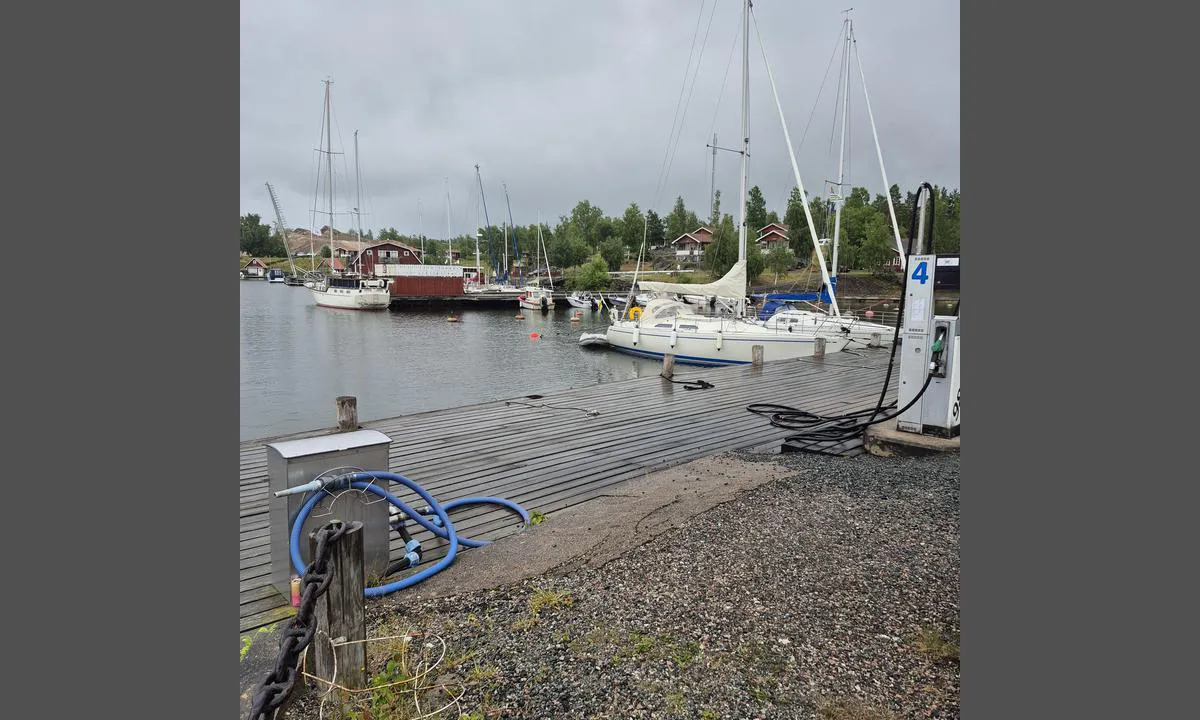
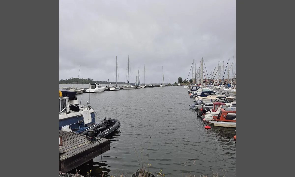
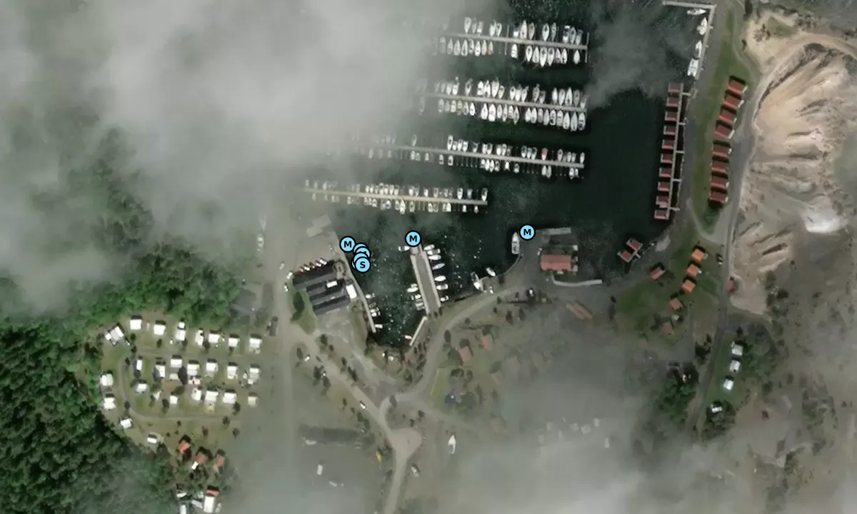
















Herräng: {"base": "en", "no": "Gjesteplattformer og drivstoffkai", "se": "G\u00e4stpontong och br\u00e4nslebrygga", "en": "Guest pontoon and fuel berth", "da": "G\u00e6steponton og br\u00e6ndstofkaj", "fr": "Pontons visiteurs et poste de ravitaillement en carburant", "de": "G\u00e4steponton und Tankstelle", "es": "Muelle de invitados y dep\u00f3sito de combustible", "it": "Pontile ospiti e banchina carburante", "pt": "Pont\u00e3o de visitantes e posto de abastecimento", "nl": "Gastenponton en tanksteiger", "pl": "Ponton dla go\u015bci i stanowisko na paliwo", "uk": "\u0413\u043e\u0441\u0442\u044c\u043e\u0432\u0430 \u043f\u0440\u0438\u0441\u0442\u0430\u043d\u044c \u0456 \u043f\u0430\u043b\u0438\u0432\u043d\u0438\u0439 \u043f\u0440\u0438\u0447\u0430\u043b", "ro": "Pontoon de oaspe\u021bi \u0219i sta\u021bie de alimentare cu combustibil", "tr": "Misafir pontonu ve yak\u0131t iskelesi", "el": "\u03a0\u03c1\u03bf\u03b2\u03bb\u03ae\u03c4\u03b1 \u03c6\u03b9\u03bb\u03bf\u03be\u03b5\u03bd\u03bf\u03c5\u03bc\u03ad\u03bd\u03c9\u03bd \u03ba\u03b1\u03b9 \u03b8\u03ad\u03c3\u03b7 \u03b1\u03bd\u03b5\u03c6\u03bf\u03b4\u03b9\u03b1\u03c3\u03bc\u03bf\u03cd \u03ba\u03b1\u03c5\u03c3\u03af\u03bc\u03c9\u03bd", "cs": "Ponton pro hosty a molo pro tankov\u00e1n\u00ed", "hu": "Vend\u00e9gpontoon \u00e9s \u00fczemanyagt\u00f6lt\u0151 hely", "fi": "Vieraslaituri ja polttoainelaituri", "bg": "\u0413\u043e\u0441\u0442\u0443\u0432\u0430\u0449 \u043f\u043e\u043d\u0442\u043e\u043d \u0438 \u0437\u0430\u0440\u0435\u0436\u0434\u0430\u043d\u0435 \u0441 \u0433\u043e\u0440\u0438\u0432\u043e", "sr": "Gostuju\u0107i ponton i benzinska stanica", "et": "K\u00fclastajate pontoon ja k\u00fctusetankla", "lv": "Viesu pontons un degvielas piest\u0101tne", "lt": "Sve\u010di\u0173 pontonas ir degal\u0173 prieplauka"}
Herräng: {"base": "en", "no": "Ser vestover", "se": "Tittar v\u00e4sterut", "en": "Looking west", "da": "Kigger mod vest", "fr": "En regardant vers l'ouest", "de": "Blick nach Westen", "es": "Mirando al oeste", "it": "Guardando a ovest", "pt": "Olhando para oeste", "nl": "Kijkend naar het westen", "pl": "Patrz\u0105c na zach\u00f3d", "uk": "\u0414\u0438\u0432\u043b\u044f\u0447\u0438\u0441\u044c \u043d\u0430 \u0437\u0430\u0445\u0456\u0434", "ro": "Privind spre vest", "tr": "Bat\u0131ya bak\u0131yor", "el": "\u039a\u03bf\u03b9\u03c4\u03ac\u03b6\u03bf\u03bd\u03c4\u03b1\u03c2 \u03b4\u03c5\u03c4\u03b9\u03ba\u03ac", "cs": "Pohled na z\u00e1pad", "hu": "Nyugat fel\u00e9 n\u00e9z", "fi": "Katsoen l\u00e4nteen", "bg": "\u0413\u043b\u0435\u0434\u0430\u0439\u043a\u0438 \u043d\u0430 \u0437\u0430\u043f\u0430\u0434", "sr": "Gledaju\u0107i prema zapadu", "et": "Vaadates l\u00e4\u00e4nde", "lv": "Skatoties uz rietumiem", "lt": "\u017di\u016brint \u012f vakarus"}
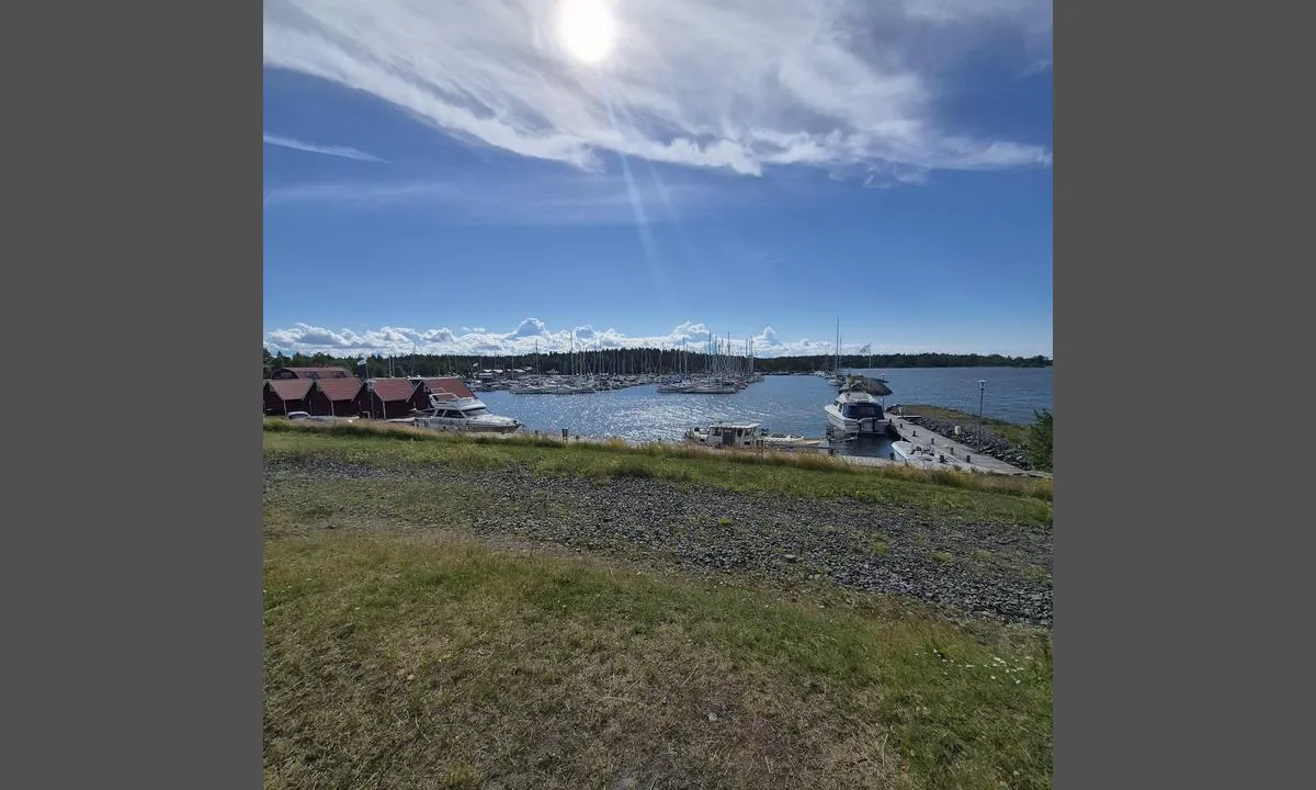
Herräng: {"base": "en", "no": "Ser mot \u00f8st", "se": "Ser \u00f6sterut", "en": "Looking East", "da": "Kigger mod \u00f8st", "fr": "Regardant vers l'est", "de": "Blick nach Osten", "es": "Mirando al Este", "it": "Guardando verso Est", "pt": "Olhando para Leste", "nl": "Kijkend naar het oosten", "pl": "Patrz\u0105c na Wsch\u00f3d", "uk": "\u0414\u0438\u0432\u043b\u044f\u0447\u0438\u0441\u044c \u043d\u0430 \u0421\u0445\u0456\u0434", "ro": "Privind spre Est", "tr": "Do\u011fuya Bak\u0131\u015f", "el": "\u039a\u03bf\u03b9\u03c4\u03ac\u03b6\u03bf\u03bd\u03c4\u03b1\u03c2 \u0391\u03bd\u03b1\u03c4\u03bf\u03bb\u03b9\u03ba\u03ac", "cs": "Pohled na v\u00fdchod", "hu": "Keletre n\u00e9zve", "fi": "Katsottaessa it\u00e4\u00e4n", "bg": "\u0413\u043b\u0435\u0434\u043a\u0430 \u043d\u0430 \u0438\u0437\u0442\u043e\u043a", "sr": "Gledaju\u0107i ka istoku", "et": "Vaade itta", "lv": "Skatoties uz Austrumiem", "lt": "\u017dvelgiant \u012f Rytus"}
Satelite image of Herräng

📸 Upload a photo

Show off your photos and help others plan their journey to Herräng.harbourmaps.com is created by the sailing community, in a collective effort to make cruising simpler and more fun. Uploading a photo takes less than a minutes and can be done from your phone, tablet or laptop.

📸 Upload a photo

Facilities

Available facilities: Shore power, Fresh water, Shower, Toilet, Washing machine, Sewage disposal, Fuel, Swimming area.

Updated on 4. Jul 2026. Update facilities.

Mooring

Options for mooring in this harbour: To pier/wharf.

Updated on 4. Jul 2026. Update mooring.

Contact information

website: Add website

phone: Add phone number

email: Add email

Descriptions and reviews

Jute of Cowes says:


area

maritime qualities

description

Easy entrance . Well sheltered in a Northerly F7/8 . Unless you are less than 10 metres I wouldn't attempt the guest pontoon .

1 x helpful | written on 4. Jul 2026

HarbourMaps (site admin) says:

description

Harbor depth: 2-7 m, Guest spots: 16 units up to 60 feet, Mooring: buoy/alongside

[translated from Swedish with AI]

0 x helpful | written on 14. Jul 2022

Do you know this harbour? It's a huge help to other sailors if you add a short description or review of the harbour.

📜 Add description

Map of Herräng

Facilities

Available facilities: Shore power, Fresh water, Shower, Toilet, Washing machine, Sewage disposal, Fuel, Swimming area.

Updated on 4. Jul 2026. Update facilities.

Mooring

Options for mooring in this harbour: To pier/wharf.

Updated on 4. Jul 2026. Update mooring.

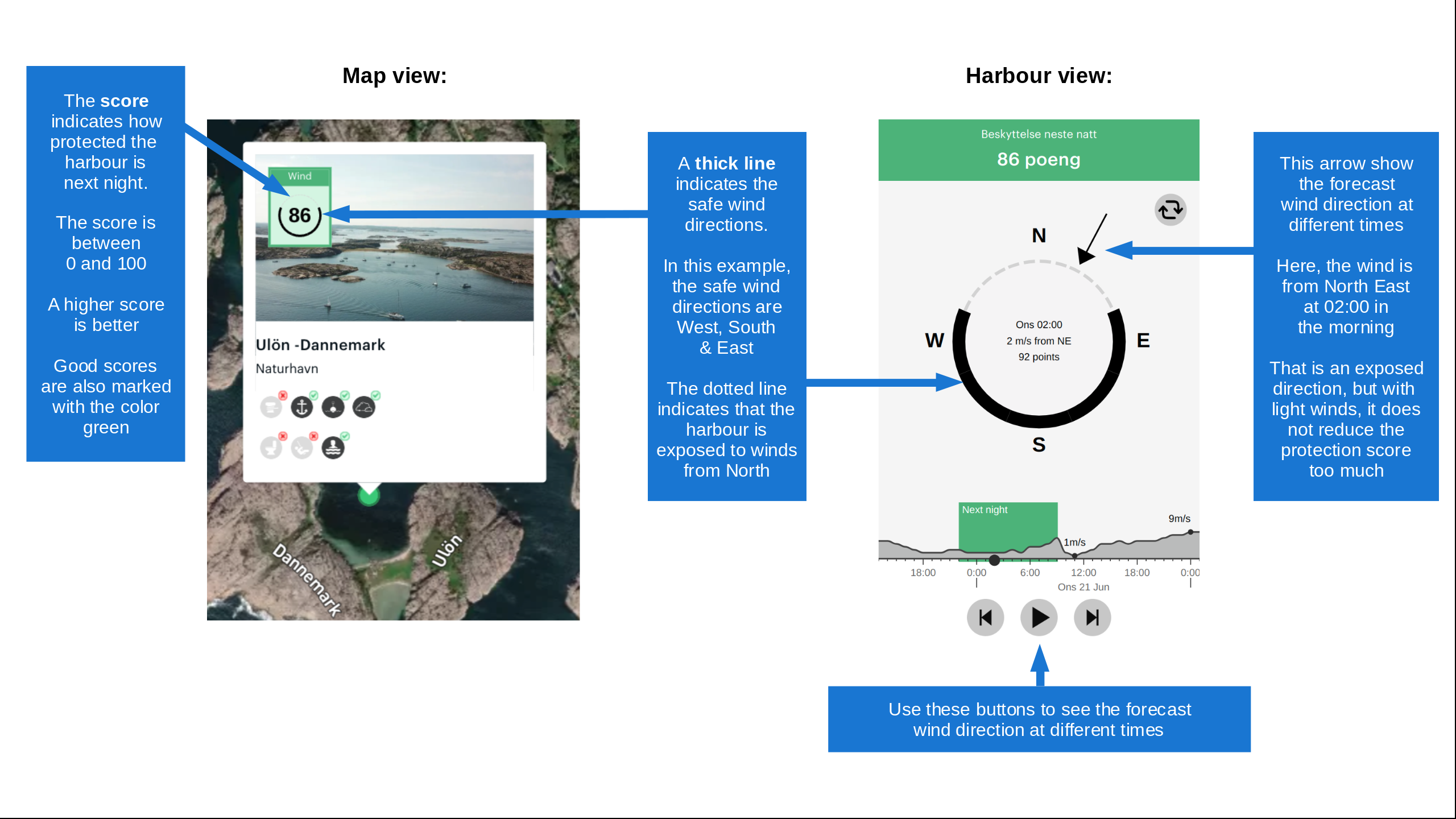
Wind protection

Protection next night

77 points

N E S W --> } } } } } } } } } } } } } } } } } } } } } } } } } } } } } } } } } } } } } } } } } } } } } } } } } } } } } } } } } } } } } } } } } } } } } } } } } } } } } } } } } } } } } } } } } } } } } } } } } } } } } } } } } } } } } } } } } } } } } } } } } } } } } } } } } } } } } } } } } } } } } } } } } } } } } } } } } } } } } } } } } } } } } } } } } } } } } } } } } } } } } } } } } } } } } } } } } } } } } } } } } } } } } } } } } } } } } } } } } } } } } } } } } } } } } } } } } } } } } } } } } } } } } } } } } } } } } } } } } } } } } } } } } } } } } } } } } } } } } } } } } } } } } } } } } } } } } } } } } } } } } } } } } } } } } } } } } } } } } } } } } } } } } } } } } } } } } } } } } } } } } } } } } } } } } } } } } } } } } } } } } } } } } } } } } } } } } } } } } } } } } } } } } } } } } } } } } } } } } } } } } } } } } } } } } } } } } } } } } } } } } } } } } } } } } } } } } } } } } } } } } } } } } } } } } } } } } } } } } } } } } } } } } } } } } } } } } } } } } } } } } } } } } } } } } } } } } } } } } } } } } } } } } } } } } } } } } } } } } } } } } } } } } } } } } } } } } } } } } } } } } } } } } } } } } } } } } } } } } } } } } } } } } } } } } } } } } } } } } } } } } } } } } } } } } } } } } } } } } } } } } } } } } } } } } } } } } } } } } } } } } } } } } } } } } } } } } } } } } } } } } } } } } } } } } } } } } } } } } } } } } } } } } } } } } } } } } } } } } } } } } } } } } } } } } } } } } } } } } } } } } } } } } } } } } } } } } } } } } } } } } } } } } } } } } } } } } } } } } } } } } } } } } } } } } } } } } } } } } } } } } } } } } } } } } } } } } } } } } } } } } } } } } } } } } } } } } } } } } } } } } } } } } } } } } } } } } } } } } } } } } } } } } } } } } } } } } } } } } } } } } } } } } } } } } } } } } } } } } } } } } } } } } } } } } } } } } } } } } } } } } } } } } } } } } } } } } } } } } } } } } } } } } } } } } } } } } } } } } } } } } } } } } } } } } } } } } } } } } } } } } } } } } } } } } } } } } } } } } } } } } } } } } } } } } } } } } } } } } } } } Next night 6:00 12:00 Søn 16 Aug 18:00 0:00 6:00 12:00 Man 17 Aug 7m/s 3m/s

Want to know how the wind score works? Then you should read this explanation.

The wind forecasts come from yr.no (Norwegian Meteorological Institute), and was last updated 1 hour and 4 minutes ago (Sunday 16 August 05:31 AM). The next night score shows you the worst hour between 22:00 and 08:00 the next night. We recommend that you check multiple sources for wind forecasts. windy.com is a good website to show larger wind systems.

The safe wind directions for this harbour has been decided by an algorithm, based on how elevated the land around the harbour is. It's mostly correct, but sometimes the underlying data about elevation levels is not good enough to make correct decisions. It's a great help to other if you can validate or adjust the safe wind directions. You can see the data used by the algorithm to decide the safe wind directions by clicking here.

Last visits to Herräng

Tue 04 Aug 2026

ETOILE DE MER [MMSI: 265689000]

Sat 27 Jun 2026

ATLANTIC ROSE [MMSI: 265541070]

Fri 17 Apr 2026

ROGUE TRADER [MMSI: 265010730]

Wed 24 Sep 2025

BLUE DRAGON [MMSI: 265027630]

Thu 18 Sep 2025

MISS G [MMSI: 265701400]

The visits are retrieved from AIS data. You can click to see all visiting ships to Herräng, as well as statistics about the ships that visits

Add this harbour to a journey

Check in now

Choose a different date than today

Important: When you check in to a harbour, you add it to a journey on this website. You are not booking a place in the marina.

Contributors

Users that contributed to this page: Jute of Cowes

harbourmaps.com is updated by the boating community. When you add information, a review or pictures to this page you are listed here with the other contributors (we list your user-name, which can be your real name or a pseudonym).

Closest harbours to Herräng

Filter by

Natural harbour
Marina
Safe wind next night

Order by

ABC
Popularity
Wind score next night

0 harbours

Show more harbours