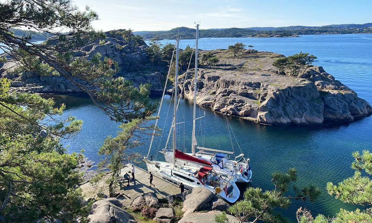
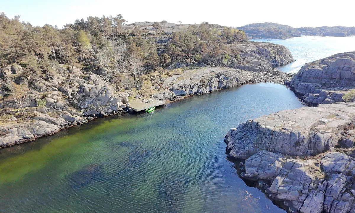
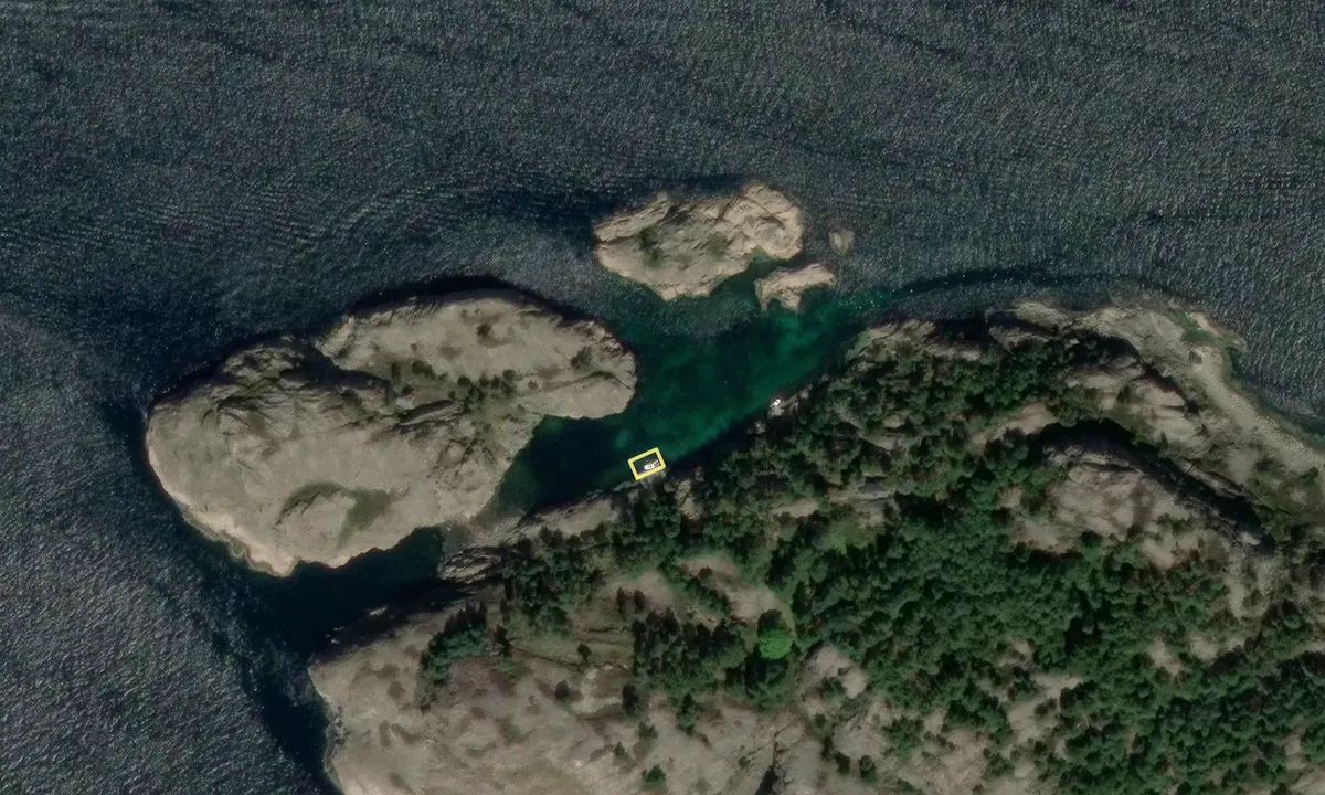
Message from the system: You need to be logged in to upload images. You can either log in or create a new user.

Message from the system: Please log in to access this page.

Message from the system: You need to be logged in to share images. You can either log in or create a new user.

Message from the system: Please log in to access this page.

Message from the system: Please log in to access this page.

Indre Hellersøya

Natural harbour

favoritt

Region: Norway (3426), Agder (282), Vest-Agder (141), Kristiansand (49), Søgne (18) and Søvik (8)

{"base": "no", "no": "Den offentlige brygga p\u00e5 Indre Hellers\u00f8ya (OBS: Grunt farvann 2-3 meter).", "se": "Den offentliga kajen p\u00e5 Inre Hellers\u00f6ya (OBS: Grundt vatten 2-3 meter).", "en": "The public pier at Indre Hellers\u00f8ya (NOTE: Shallow waters 2-3 meters).", "da": "Den offentlige bro p\u00e5 Indre Hellers\u00f8ya (OBS: Lavt vand 2-3 meter).", "fr": "Le quai public \u00e0 Indre Hellers\u00f8ya (ATTENTION : eaux peu profondes 2-3 m\u00e8tres).", "de": "Der \u00f6ffentliche Steg auf Indre Hellers\u00f8ya (Achtung: Flaches Gew\u00e4sser 2-3 Meter).", "es": "El muelle p\u00fablico en Indre Hellers\u00f8ya (OBS: Aguas poco profundas de 2-3 metros).", "it": "Il molo pubblico su Indre Hellers\u00f8ya (ATTENZIONE: acque basse 2-3 metri).", "pt": "O cais p\u00fablico em Indre Hellers\u00f8ya (ATEN\u00c7\u00c3O: \u00c1guas rasas de 2-3 metros).", "nl": "De openbare steiger op Indre Hellers\u00f8ya (NB: Ondiep water 2-3 meter).", "pl": "Publiczny pomost na Indre Hellers\u00f8ya (UWAGA: P\u0142ytkie wody 2-3 metry).", "uk": "\u0413\u0440\u043e\u043c\u0430\u0434\u0441\u044c\u043a\u0438\u0439 \u043f\u0440\u0438\u0447\u0430\u043b \u043d\u0430 \u0406\u043d\u043d\u0435\u0440 \u0413\u0435\u043b\u043b\u0435\u0440\u044c\u043e\u0439\u044f (\u0423\u0412\u0410\u0413\u0410: \u041c\u0456\u043b\u043a\u043e\u0432\u043e\u0434\u0434\u044f 2-3 \u043c\u0435\u0442\u0440\u0438).", "ro": "Cheiul public de pe Insula Interioar\u0103 Hellers\u00f8ya (NOT\u0102: Ap\u0103 mic\u0103 de 2-3 metri).", "tr": "\u0130\u00e7 Hellers\u00f8ya'daki kamu iskelesi (D\u0130KKAT: S\u0131\u011f sular 2-3 metre).", "el": "\u0397 \u03b4\u03b7\u03bc\u03cc\u03c3\u03b9\u03b1 \u03c0\u03c1\u03bf\u03b2\u03bb\u03ae\u03c4\u03b1 \u03c3\u03c4\u03b7\u03bd \u0395\u03c3\u03c9\u03c4\u03b5\u03c1\u03b9\u03ba\u03ae \u039d\u03ae\u03c3\u03bf \u03a7\u03ad\u03bb\u03bb\u03b5\u03c1\u03c3\u03cc\u03b3\u03b9\u03b1 (\u03a0\u03a1\u039f\u03a3\u039f\u03a7\u0397: \u03a1\u03b7\u03c7\u03ac \u03bd\u03b5\u03c1\u03ac 2-3 \u03bc\u03ad\u03c4\u03c1\u03b1).", "cs": "Ve\u0159ejn\u00e9 molo na Indre Hellers\u00f8ya (POZOR: M\u011blk\u00e9 vody 2-3 metry).", "hu": "A nyilv\u00e1nos m\u00f3l\u00f3 Indre Hellers\u00f8ya-n (FIGYELEM: Sek\u00e9ly v\u00edz 2-3 m\u00e9ter).", "fi": "Julkinen laituri Indre Hellers\u00f8yalla (HUOM: Matalavesialue 2-3 metri\u00e4).", "bg": "\u041e\u0431\u0449\u0435\u0441\u0442\u0432\u0435\u043d\u0438\u044f\u0442 \u043a\u0435\u0439 \u043d\u0430 \u0412\u044a\u0442\u0440\u0435\u0448\u0435\u043d \u0425\u0435\u043b\u043b\u0435\u0440\u0441\u043e\u0439\u0430 (\u0417\u0410\u0411\u0415\u041b\u0415\u0416\u041a\u0410: \u041f\u043b\u0438\u0442\u043a\u0438 \u0432\u043e\u0434\u0438 2-3 \u043c\u0435\u0442\u0440\u0430).", "sr": "Javna pristani\u0161ta na Indre Hellers\u00f8ya (PA\u017dNJA: Plitke vode 2-3 metra).", "et": "Indre Hellers\u00f8ya avalik kai (T\u00e4helepanu: Madalad veed 2-3 meetrit).", "lv": "Publisk\u0101 piest\u0101tne uz Indre Hellers\u00f8ya (UZMAN\u012aBU: Seklie \u016bde\u0146i 2-3 metri).", "lt": "Vie\u0161asis prieplauka Indre Hellers\u00f8ya (D\u0116MESIO: Negilu vanduo 2-3 metrai)."}
Satelite image of Indre Hellersøya

📸 Upload a photo

Show off your photos and help others plan their journey to Indre Hellersøya.harbourmaps.com is created by the sailing community, in a collective effort to make cruising simpler and more fun. Uploading a photo takes less than a minutes and can be done from your phone, tablet or laptop.

📸 Upload a photo

Facilities

We don't have any data on available facilities in this harbour. If you know which facilities are available here, please update this site to help your fellow sailors. Update facilities.

Mooring

Options for mooring in this harbour: To pier/wharf.

Updated on 1. Oct 2025. Update mooring.

Descriptions and reviews

Knut Kjorkleiv says:

area

maritime qualities

description

A small public dock with a bench and grill. No toilet or other facilities. Shallow and somewhat narrow waters, so be aware. Very sheltered from the sea, but it can get windy with SW, which often occurs.
Nice view over the archipelago from the top of the island, beyond that it doesn't have much to offer. There is a private cabin roughly in the middle of the island, otherwise no buildings.

[translated from Norwegian with AI]

1 x helpful | written on 29. Sep 2025 | updated_on 29. Sep 2025

Do you know this harbour? It's a huge help to other sailors if you add a short description or review of the harbour.

📜 Add description

Map of Indre Hellersøya

Facilities

We don't have any data on available facilities in this harbour. If you know which facilities are available here, please update this site to help your fellow sailors. Update facilities.

Mooring

Options for mooring in this harbour: To pier/wharf.

Updated on 1. Oct 2025. Update mooring.

Wind protection

Protection next night

40 points

N E S W --> } } } } } } } } } } } } } } } } } } } } } } } } } } } } } } } } } } } } } } } } } } } } } } } } } } } } } } } } } } } } } } } } } } } } } } } } } } } } } } } } } } } } } } } } } } } } } } } } } } } } } } } } } } } } } } } } } } } } } } } } } } } } } } } } } } } } } } } } } } } } } } } } } } } } } } } } } } } } } } } } } } } } } } } } } } } } } } } } } } } } } } } } } } } } } } } } } } } } } } } } } } } } } } } } } } } } } } } } } } } } } } } } } } } } } } } } } } } } } } } } } } } } } } } } } } } } } } } } } } } } } } } } } } } } } } } } } } } } } } } } } } } } } } } } } } } } } } } } } } } } } } } } } } } } } } } } } } } } } } } } } } } } } } } } } } } } } } } } } } } } } } } } } } } } } } } } } } } } } } } } } } } } } } } } } } } } } } } } } } } } } } } } } } } } } } } } } } } } } } } } } } } } } } } } } } } } } } } } } } } } } } } } } } } } } } } } } } } } } } } } } } } } } } } } } } } } } } } } } } } } } } } } } } } } } } } } } } } } } } } } } } } } } } } } } } } } } } } } } } } } } } } } } } } } } } } } } } } } } } } } } } } } } } } } } } } } } } } } } } } } } } } } } } } } } } } } } } } } } } } } } } } } } } } } } } } } } } } } } } } } } } } } } } } } } } } } } } } } } } } } } } } } } } } } } } } } } } } } } } } } } } } } } } } } } } } } } } } } } } } } } } } } } } } } } } } } } } } } } } } } } } } } } } } } } } } } } } } } } } } } } } } } } } } } } } } } } } } } } } } } } } } } } } } } } } } } } } } } } } } } } } } } } } } } } } } } } } } } } } } } } } } } } } } } } } } } } } } } } } } } } } } } } } } } } } } } } } } } } } } } } } } } } } } } } } } } } } } } } } } } } } } } } } } } } } } } } } } } } } } } } } } } } } } } } } } } } } } } } } } } } } } } } } } } } } } } } } } } } } } } } } } } } } } } } } } } } } } } } } } } } } } } } } } } } } } } } } } } } } } } } } } } } } } } } } } } } } } } } } } } } } } } } } } } } } } } } } } } } } } } } } } } } } } } } } } } } } } } } } } } } } } } } } } } } } } } } } } } } } } } Next night 12:00 Lør 04 Okt 18:00 0:00 6:00 12:00 Søn 05 Okt 18:00 14m/s 4m/s

Want to know how the wind score works? Then you should read this explanation.

The wind forecasts come from yr.no (Norwegian Meteorological Institute), and was last updated 2 hours and 16 minutes ago (Saturday 04 October 08:26 AM). The next night score shows you the worst hour between 22:00 and 08:00 the next night. We recommend that you check multiple sources for wind forecasts. windy.com is a good website to show larger wind systems.

The safe wind directions for this harbour has been decided by an algorithm, based on how elevated the land around the harbour is. It's mostly correct, but sometimes the underlying data about elevation levels is not good enough to make correct decisions. It's a great help to other if you can validate or adjust the safe wind directions. You can see the data used by the algorithm to decide the safe wind directions by clicking here.

Last visits to Indre Hellersøya

The visits are retrieved from AIS data. You can click to see all visiting ships to Indre Hellersøya, as well as statistics about the ships that visits

Add this harbour to a journey

Check in now

Choose a different date than today

Important: When you check in to a harbour, you add it to a journey on this website. You are not booking a place in the marina.

Contributors

Users that contributed to this page: Knut Kjorkleiv

harbourmaps.com is updated by the boating community. When you add information, a review or pictures to this page you are listed here with the other contributors (we list your user-name, which can be your real name or a pseudonym).

Closest harbours to Indre Hellersøya

Filter by

Natural harbour
Marina
Safe wind next night

Order by

ABC
Popularity
Wind score next night

0 harbours

Show more harbours