Sandbukta, Randøya

Natural harbour

favoritt

Region: Norway (3278), Agder (252), Vest-Agder (123) and Kristiansand (40)

Sandbukta, Randøya : {"base": "no", "no": "Oppe til h\u00f8yre i bilde er det vanligste stedet \u00e5 legge til. Her er fin plen, flotte svaberg og Offentlig toalett. Rand\u00f8ya er ogs\u00e5 en utrolig fin \u00f8y \u00e5 g\u00e5 tur p\u00e5. Gammelt milit\u00e6romr\u00e5det med masse historie", "se": "Uppe till h\u00f6ger i bilden \u00e4r den vanligaste platsen att l\u00e4gga till. H\u00e4r finns en fin gr\u00e4smatta, vackra klippor och Offentlig toalett. Rand\u00f6 \u00e4r ocks\u00e5 en otroligt fin \u00f6 att promenera p\u00e5. Gammalt milit\u00e4romr\u00e5de med mycket historia", "en": "At the top right in the picture is the most common place to dock. Here, there is a beautiful lawn, lovely rocky outcrops, and public toilets. Rand\u00f8ya is also an incredibly nice island to take a walk on. It is an old military area with lots of history.", "da": "Oppe til h\u00f8jre i billedet er det mest almindelige sted at l\u00e6gge til. Her er fin pl\u00e6ne, flotte klipper og Offentligt toilet. Rand\u00f8ya er ogs\u00e5 en utrolig fin \u00f8 at g\u00e5 tur p\u00e5. Gamle milit\u00e6romr\u00e5det med masser af historie."}
Sandbukta, Randøya : {"base": "no", "no": "Bukta sett fra \u00f8st, mot nord/vest", "se": "Bukten sedd fr\u00e5n \u00f6st, mot nord/v\u00e4st", "en": "The bay seen from the east, towards the north/west", "da": "Bugten set fra \u00f8st, mod nord/vest"}
Sandbukta, Randøya
Sandbukta, Randøya : {"base": "no", "no": "Innl\u00f8pet til bukta. Pass p\u00e5 skj\u00e6ret midt i sundet", "se": "Inloppet till bukten. Se upp f\u00f6r sk\u00e4ret mitt i sundet", "en": "The entrance to the bay. Watch out for the reef in the middle of the strait", "da": "Indl\u00f8bet til bugten. V\u00e6r opm\u00e6rksom p\u00e5 sk\u00e6ret midt i sundet"}
Satelite image of Sandbukta, Randøya

📸 Upload a photo

Show off your photos and help others plan their journey to Sandbukta, Randøya .harbourmaps.com is created by the sailing community, in a collective effort to make cruising simpler and more fun. Uploading a photo takes less than a minutes and can be done from your phone, tablet or laptop.

📸 Upload a photo

Facilities

Available facilities: Toilet, Swimming area.

Updated on 29. Dec 2022. Update facilities.

Mooring

Options for mooring in this harbour: Anchoring, Towards land.

Updated on 29. Dec 2022. Update mooring.

Descriptions and reviews

Preben Mollestad says:

area

maritime qualities

description

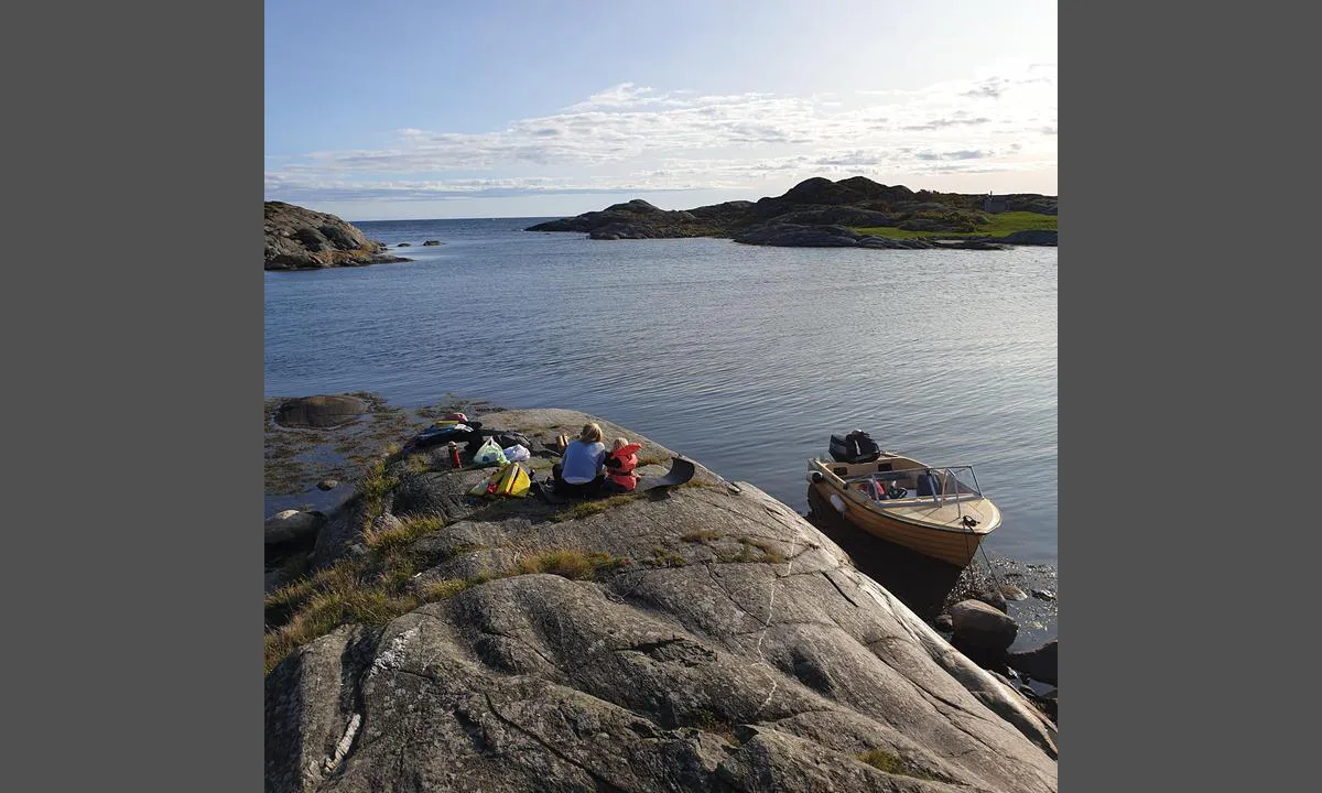
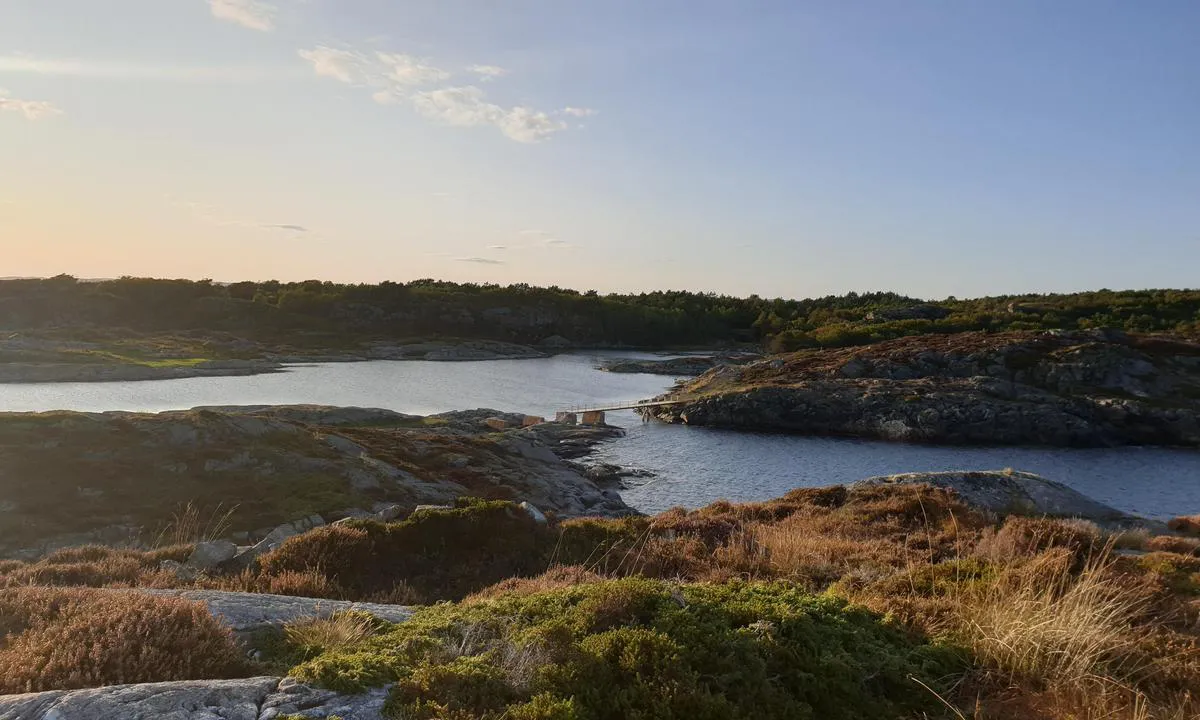
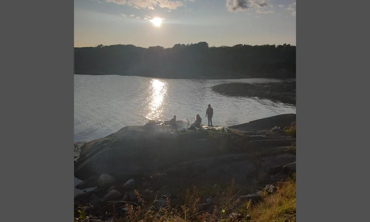
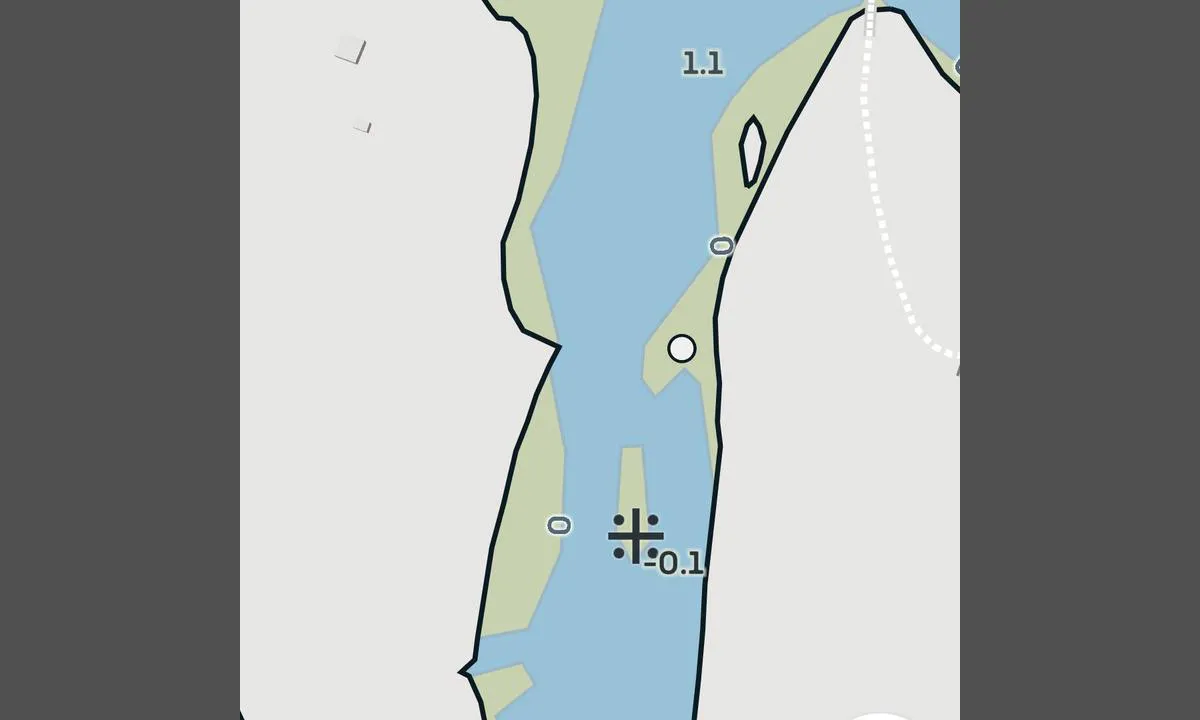
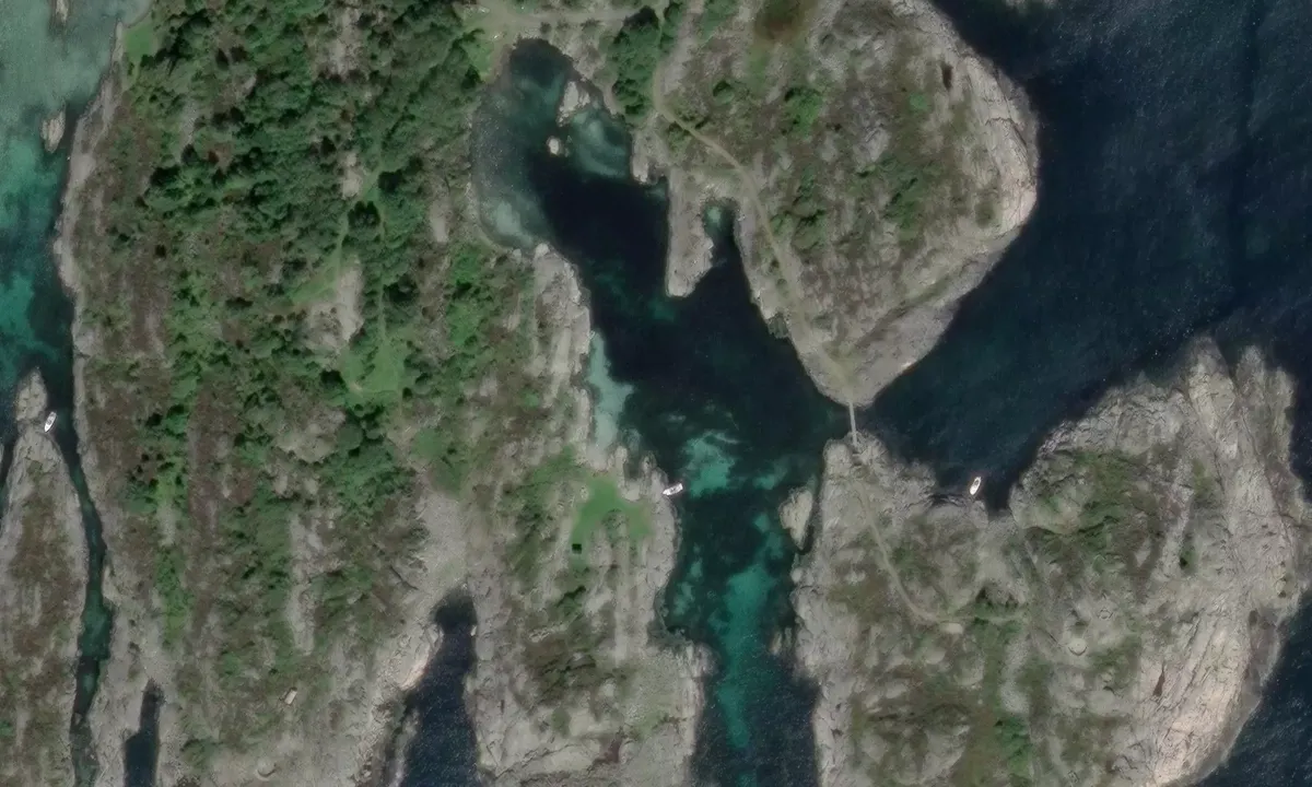
The harbor can be a bit rough to enter in strong winds. There is also a splash reef in the inlet roughly in the middle. It is best to stay a little to the left on the way in. See map picture. Once you have moored, there is a very nice oasis of smooth cliffs and green lawn. The island is also excellent for hiking and cycling as it is an old military area with countless trails and roads.

[translated from Norwegian with AI]

1 x helpful | written on 29. Dec 2022 | updated_on 29. Dec 2022

Do you know this harbour? It's a huge help to other sailors if you add a short description or review of the harbour.

📜 Add description

Map of Sandbukta, Randøya

Facilities

Available facilities: Toilet, Swimming area.

Updated on 29. Dec 2022. Update facilities.

Mooring

Options for mooring in this harbour: Anchoring, Towards land.

Updated on 29. Dec 2022. Update mooring.

Wind protection

Protection next night

89 points

N E S W --> } } } } } } } } } } } } } } } } } } } } } } } } } } } } } } } } } } } } } } } } } } } } } } } } } } } } } } } } } } } } } } } } } } } } } } } } } } } } } } } } } } } } } } } } } } } } } } } } } } } } } } } } } } } } } } } } } } } } } } } } } } } } } } } } } } } } } } } } } } } } } } } } } } } } } } } } } } } } } } } } } } } } } } } } } } } } } } } } } } } } } } } } } } } } } } } } } } } } } } } } } } } } } } } } } } } } } } } } } } } } } } } } } } } } } } } } } } } } } } } } } } } } } } } } } } } } } } } } } } } } } } } } } } } } } } } } } } } } } } } } } } } } } } } } } } } } } } } } } } } } } } } } } } } } } } } } } } } } } } } } } } } } } } } } } } } } } } } } } } } } } } } } } } } } } } } } } } } } } } } } } } } } } } } } } } } } } } } } } } } } } } } } } } } } } } } } } } } } } } } } } } } } } } } } } } } } } } } } } } } } } } } } } } } } } } } } } } } } } } } } } } } } } } } } } } } } } } } } } } } } } } } } } } } } } } } } } } } } } } } } } } } } } } } } } } } } } } } } } } } } } } } } } } } } } } } } } } } } } } } } } } } } } } } } } } } } } } } } } } } } } } } } } } } } } } } } } } } } } } } } } } } } } } } } } } } } } } } } } } } } } } } } } } } } } } } } } } } } } } } } } } } } } } } } } } } } } } } } } } } } } } } } } } } } } } } } } } } } } } } } } } } } } } } } } } } } } } } } } } } } } } } } } } } } } } } } } } } } } } } } } } } } } } } } } } } } } } } } } } } } } } } } } } } } } } } } } } } } } } } } } } } } } } } } } } } } } } } } } } } } } } } } } } } } } } } } } } } } } } } } } } } } } } } } } } } } } } } } } } } } } } } } } } } } } } } } } } } } } } } } } } } } } } } } } } } } } } } } } } } } } } } } } } } } } } } } } } } } } } } } } } } } } } } } } } } } } } } } } } } } } } } } } } } } } } } } } } } } } } } } } } } } } } } } } } } } } } } } } } } } } } } } } } } } } } } } } } } } } } } } } } } } } } } } } } } } } } } } } } } } } } } } } } } } } } } } } } } } } } } } } } } } } } } } } } } } } } } } } } } } Next night 0:00 6:00 12:00 Tor 01 Mai 18:00 0:00 6:00 9m/s 2m/s

Want to know how the wind score works? Then you should read this explanation.

The wind forecasts come from yr.no (Norwegian Meteorological Institute), and was last updated 2 hours and 2 minutes ago (Wednesday 30 April 08:28 PM). The next night score shows you the worst hour between 22:00 and 08:00 the next night. We recommend that you check multiple sources for wind forecasts. windy.com is a good website to show larger wind systems.

The safe wind directions for this harbour has been decided by an algorithm, based on how elevated the land around the harbour is. It's mostly correct, but sometimes the underlying data about elevation levels is not good enough to make correct decisions. It's a great help to other if you can validate or adjust the safe wind directions. You can see the data used by the algorithm to decide the safe wind directions by clicking here.

Last visits to Sandbukta, Randøya

The visits are retrieved from AIS data. You can click to see all visiting ships to Sandbukta, Randøya , as well as statistics about the ships that visits

Add this harbour to a journey

Check in now

Choose a different date than today

Important: When you check in to a harbour, you add it to a journey on this website. You are not booking a place in the marina.

Contributors

Users that contributed to this page: Preben Mollestad

harbourmaps.com is updated by the boating community. When you add information, a review or pictures to this page you are listed here with the other contributors (we list your user-name, which can be your real name or a pseudonym).

Closest harbours to Sandbukta, Randøya

Filter by

Natural harbour
Marina
Safe wind next night

Order by

ABC
Popularity
Wind score next night

0 harbours

Show more harbours