Sarstangen nord

Natural harbour

favoritt

Region: Svalbard (71), Svalbard and Jan Mayen (67) and Svalbard (64)

Sarstangen nord: View of the eastern part of the anchorage
Sarstangen nord: {"base": "en", "no": "Den vestlige delen av ankringsplassen", "se": "Den v\u00e4stra delen av ankringsplatsen", "en": "The western part of the anchorage", "da": "Den vestlige del af ankerpladsen", "fr": "La partie ouest de la zone de mouillage", "de": "Der westliche Teil des Ankerplatzes", "es": "La parte occidental del fondeadero", "it": "La parte occidentale del ancoraggio", "pt": "A parte ocidental da ancoragem", "nl": "Het westelijke deel van het ankergebied", "pl": "Zachodnia cz\u0119\u015b\u0107 kotwicowiska", "uk": "\u0417\u0430\u0445\u0456\u0434\u043d\u0430 \u0447\u0430\u0441\u0442\u0438\u043d\u0430 \u044f\u043a\u043e\u0440\u043d\u043e\u0457 \u0441\u0442\u043e\u044f\u043d\u043a\u0438", "ro": "Partea de vest a ancorajului", "tr": "Demirleme yerinin bat\u0131 k\u0131sm\u0131", "el": "\u03a4\u03bf \u03b4\u03c5\u03c4\u03b9\u03ba\u03cc \u03c4\u03bc\u03ae\u03bc\u03b1 \u03c4\u03bf\u03c5 \u03b1\u03b3\u03ba\u03c5\u03c1\u03bf\u03b2\u03bf\u03bb\u03af\u03bf\u03c5", "cs": "Z\u00e1padn\u00ed \u010d\u00e1st kotvi\u0161t\u011b", "hu": "A horgonyz\u00e1s nyugati r\u00e9sze", "fi": "Ankkuripaikan l\u00e4nsiosa", "bg": "\u0417\u0430\u043f\u0430\u0434\u043d\u0430\u0442\u0430 \u0447\u0430\u0441\u0442 \u043d\u0430 \u043a\u043e\u0442\u0432\u0435\u043d\u043e\u0442\u043e \u043c\u044f\u0441\u0442\u043e", "sr": "Zapadni deo sidri\u0161ta", "et": "Ankruala l\u00e4\u00e4nepoolne osa", "lv": "Enkura vietas rietumu da\u013ca", "lt": "Vakar\u0173 dalis inkaraviet\u0117s"}
Sarstangen nord
Satelite image of Sarstangen nord

📸 Upload a photo

Show off your photos and help others plan their journey to Sarstangen nord.harbourmaps.com is created by the sailing community, in a collective effort to make cruising simpler and more fun. Uploading a photo takes less than a minutes and can be done from your phone, tablet or laptop.

📸 Upload a photo

Facilities

We don't have any data on available facilities in this harbour. If you know which facilities are available here, please update this site to help your fellow sailors. Update facilities.

Mooring

Options for mooring in this harbour: Anchoring.

Updated on 11. Jun 2025. Update mooring.

Descriptions and reviews

Chris SV Blue Peter says:

area

maritime qualities

description

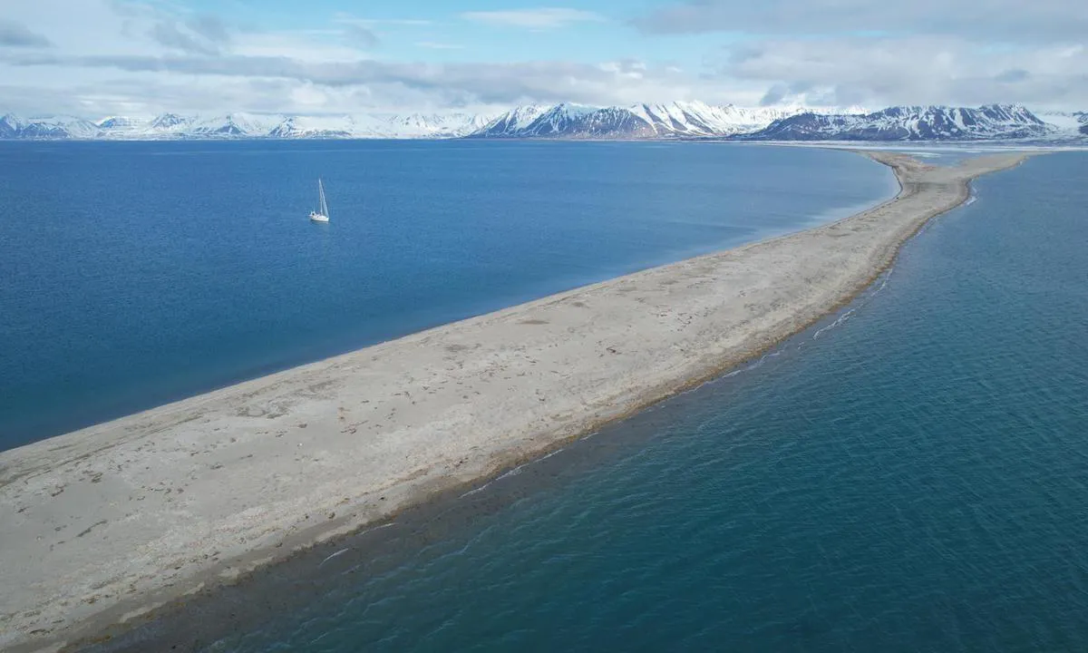
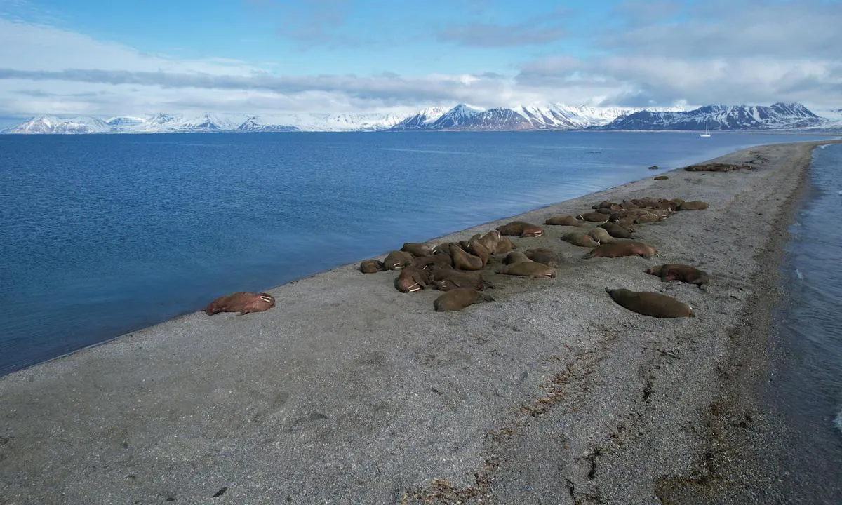
Très beau mouillage atypique, protégé par un cordon littoral s’étendant sur plus de 3 milles nautiques. Ce cordon, composé de sable, s’est formé en remplacement de l’estran tel que représenté sur les cartes marines, offrant une bonne protection contre la houle de secteur sud. À l’extrémité de ce cordon, plusieurs colonies de morses sont fréquemment observées.

Approche : le courant du chenal peut être assez vif. De H-3 à H+3 par rapport à la pleine mer, le flot porte vers le nord.

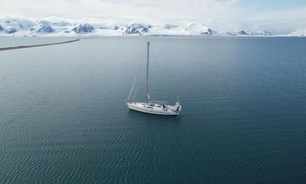
Mouillage : on mouille par 5 à 6 mètres d’eau, sur fond de sable, à environ 3 encablures à l’ouest du phare, sensiblement à mi-distance entre celui-ci et l’extrémité ouest de la péninsule.

1 x helpful | written on 11. Jun 2025 | updated_on 11. Jun 2025

Do you know this harbour? It's a huge help to other sailors if you add a short description or review of the harbour.

📜 Add description

Map of Sarstangen nord

Facilities

We don't have any data on available facilities in this harbour. If you know which facilities are available here, please update this site to help your fellow sailors. Update facilities.

Mooring

Options for mooring in this harbour: Anchoring.

Updated on 11. Jun 2025. Update mooring.

Wind protection

Protection next night

75 points

N E S W --> } } } } } } } } } } } } } } } } } } } } } } } } } } } } } } } } } } } } } } } } } } } } } } } } } } } } } } } } } } } } } } } } } } } } } } } } } } } } } } } } } } } } } } } } } } } } } } } } } } } } } } } } } } } } } } } } } } } } } } } } } } } } } } } } } } } } } } } } } } } } } } } } } } } } } } } } } } } } } } } } } } } } } } } } } } } } } } } } } } } } } } } } } } } } } } } } } } } } } } } } } } } } } } } } } } } } } } } } } } } } } } } } } } } } } } } } } } } } } } } } } } } } } } } } } } } } } } } } } } } } } } } } } } } } } } } } } } } } } } } } } } } } } } } } } } } } } } } } } } } } } } } } } } } } } } } } } } } } } } } } } } } } } } } } } } } } } } } } } } } } } } } } } } } } } } } } } } } } } } } } } } } } } } } } } } } } } } } } } } } } } } } } } } } } } } } } } } } } } } } } } } } } } } } } } } } } } } } } } } } } } } } } } } } } } } } } } } } } } } } } } } } } } } } } } } } } } } } } } } } } } } } } } } } } } } } } } } } } } } } } } } } } } } } } } } } } } } } } } } } } } } } } } } } } } } } } } } } } } } } } } } } } } } } } } } } } } } } } } } } } } } } } } } } } } } } } } } } } } } } } } } } } } } } } } } } } } } } } } } } } } } } } } } } } } } } } } } } } } } } } } } } } } } } } } } } } } } } } } } } } } } } } } } } } } } } } } } } } } } } } } } } } } } } } } } } } } } } } } } } } } } } } } } } } } } } } } } } } } } } } } } } } } } } } } } } } } } } } } } } } } } } } } } } } } } } } } } } } } } } } } } } } } } } } } } } } } } } } } } } } } } } } } } } } } } } } } } } } } } } } } } } } } } } } } } } } } } } } } } } } } } } } } } } } } } } } } } } } } } } } } } } } } } } } } } } } } } } } } } } } } } } } } } } } } } } } } } } } } } } } } } } } } } } } } } } } } } } } } } } } } } } } } } } } } } } } } } } } } } } } } } } } } } } } } } } } } } } } } } } } } } } } } } } } } } } } } } } } } } } } } } } } } } } } } } } } } } } } } } } } } } } } } } } } } } } } } } } } } } } } } } } } } } } } } } } } } } } } } } } } Next night 12:00 Lør 14 Jun 18:00 0:00 6:00 12:00 Søn 15 Jun 18:00 5m/s 0m/s

Want to know how the wind score works? Then you should read this explanation.

The wind forecasts come from yr.no (Norwegian Meteorological Institute), and was last updated 2 hours and 6 minutes ago (Saturday 14 June 07:14 AM). The next night score shows you the worst hour between 22:00 and 08:00 the next night. We recommend that you check multiple sources for wind forecasts. windy.com is a good website to show larger wind systems.

The safe wind directions for this harbour has been decided by an algorithm, based on how elevated the land around the harbour is. It's mostly correct, but sometimes the underlying data about elevation levels is not good enough to make correct decisions. It's a great help to other if you can validate or adjust the safe wind directions. You can see the data used by the algorithm to decide the safe wind directions by clicking here.

Last visits to Sarstangen nord

Sun 16 Jun 2024

MEANDER [MMSI: 244630128]

The visits are retrieved from AIS data. You can click to see all visiting ships to Sarstangen nord, as well as statistics about the ships that visits

Add this harbour to a journey

Check in now

Choose a different date than today

Important: When you check in to a harbour, you add it to a journey on this website. You are not booking a place in the marina.

Contributors

Users that contributed to this page: Chris SV Blue Peter

harbourmaps.com is updated by the boating community. When you add information, a review or pictures to this page you are listed here with the other contributors (we list your user-name, which can be your real name or a pseudonym).

Closest harbours to Sarstangen nord

Filter by

Natural harbour
Marina
Safe wind next night

Order by

ABC
Popularity
Wind score next night

0 harbours

Show more harbours