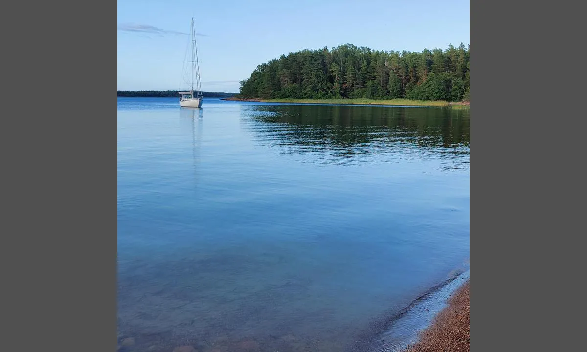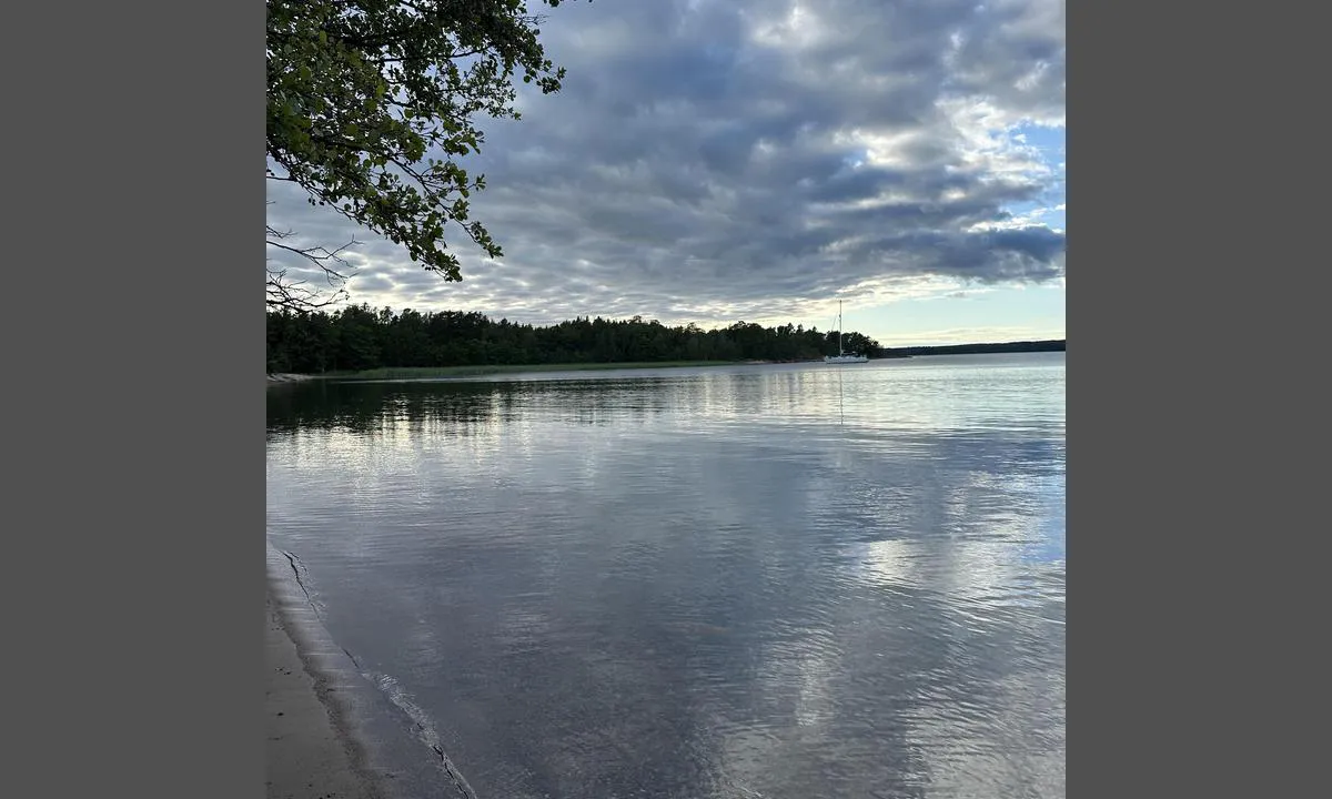

















Skötviken: {"base": "en", "no": "Ankret p\u00e5 \u00f8stsiden av bukten. Vanndybde omtrent 3-4 meter. Grunnere rett foran sandstranden. Sand- og mudderbunn.", "se": "Ankrade p\u00e5 \u00f6stra sidan av bukten. Vattendjup cirka 3-4 meter. Grundare precis framf\u00f6r sandstranden. Sand- och lerbotten.", "en": "Anchored on the east side of the bay. Water depth about 3-4 meters. Shallower right in front of the sandy beach. Sand and mud base.", "da": "Ankret p\u00e5 \u00f8stsiden af bugten. Vanddybde omkring 3-4 meter. Mindre dybde lige foran sandstranden. Sand- og mudderbund.", "fr": "Ancr\u00e9 du c\u00f4t\u00e9 est de la baie. Profondeur de l'eau d'environ 3-4 m\u00e8tres. Plus peu profond juste en face de la plage de sable. Fond de sable et de boue.", "de": "Ankerplatz auf der Ostseite der Bucht. Wassertiefe etwa 3-4 Meter. Flacher direkt vor dem Sandstrand. Sand- und Schlammboden.", "es": "Anclado en el lado este de la bah\u00eda. Profundidad del agua aproximadamente 3-4 metros. M\u00e1s superficial justo en frente de la playa de arena. Fondo de arena y lodo.", "it": "Ancorato sul lato est della baia. Profondit\u00e0 dell'acqua circa 3-4 metri. Meno profonda proprio di fronte alla spiaggia di sabbia. Fondale di sabbia e fango.", "pt": "Ancorado no lado leste da ba\u00eda. Profundidade da \u00e1gua cerca de 3-4 metros. Mais raso bem em frente \u00e0 praia arenosa. Base de areia e lama.", "nl": "Voor anker aan de oostzijde van de baai. Waterdiepte ongeveer 3-4 meter. Ondieper direct voor het zandstrand. Zand- en modderbodem.", "pl": "Zakotwiczony po wschodniej stronie zatoki. G\u0142\u0119boko\u015b\u0107 wody oko\u0142o 3-4 metry. P\u0142ytsze miejsce bezpo\u015brednio przed piaszczyst\u0105 pla\u017c\u0105. Pod\u0142o\u017ce piaszczyste i muliste.", "uk": "\u042f\u043a\u0456\u0440 \u043a\u0438\u043d\u0443\u043b\u0438 \u043d\u0430 \u0441\u0445\u0456\u0434\u043d\u0456\u0439 \u0441\u0442\u043e\u0440\u043e\u043d\u0456 \u0437\u0430\u0442\u043e\u043a\u0438. \u0413\u043b\u0438\u0431\u0438\u043d\u0430 \u0432\u043e\u0434\u0438 \u043f\u0440\u0438\u0431\u043b\u0438\u0437\u043d\u043e 3-4 \u043c\u0435\u0442\u0440\u0438. \u041c\u0456\u043b\u043a\u043e\u0432\u043e\u0434\u0434\u044f \u043f\u0440\u044f\u043c\u043e \u043f\u0435\u0440\u0435\u0434 \u043f\u0456\u0449\u0430\u043d\u0438\u043c \u043f\u043b\u044f\u0436\u0435\u043c. \u0414\u043d\u043e \u043f\u0456\u0449\u0430\u043d\u0435 \u0442\u0430 \u043c\u0443\u043b\u0438\u0441\u0442\u0435.", "ro": "Ancorat pe partea de est a golfului. Ad\u00e2ncimea apei este de aproximativ 3-4 metri. Mai pu\u021bin ad\u00e2nc chiar \u00een fa\u021ba plajei nisipoase. Baz\u0103 de nisip \u0219i noroi.", "tr": "Koyun do\u011fu taraf\u0131nda demirlemi\u015f. Su derinli\u011fi yakla\u015f\u0131k 3-4 metre. Kumlu plaj\u0131n hemen \u00f6n\u00fcnde daha s\u0131\u011f. Kum ve \u00e7amur taban\u0131.", "el": "\u0391\u03b3\u03ba\u03c5\u03c1\u03c9\u03bc\u03ad\u03bd\u03bf \u03c3\u03c4\u03b7\u03bd \u03b1\u03bd\u03b1\u03c4\u03bf\u03bb\u03b9\u03ba\u03ae \u03c0\u03bb\u03b5\u03c5\u03c1\u03ac \u03c4\u03bf\u03c5 \u03ba\u03cc\u03bb\u03c0\u03bf\u03c5. \u0392\u03ac\u03b8\u03bf\u03c2 \u03bd\u03b5\u03c1\u03bf\u03cd \u03c0\u03b5\u03c1\u03af\u03c0\u03bf\u03c5 3-4 \u03bc\u03ad\u03c4\u03c1\u03b1. \u03a1\u03b7\u03c7\u03cc\u03c4\u03b5\u03c1\u03b1 \u03b1\u03ba\u03c1\u03b9\u03b2\u03ce\u03c2 \u03bc\u03c0\u03c1\u03bf\u03c3\u03c4\u03ac \u03b1\u03c0\u03cc \u03c4\u03b7\u03bd \u03b1\u03bc\u03bc\u03ce\u03b4\u03b7 \u03c0\u03b1\u03c1\u03b1\u03bb\u03af\u03b1. \u0392\u03ac\u03c3\u03b7 \u03b1\u03c0\u03cc \u03ac\u03bc\u03bc\u03bf \u03ba\u03b1\u03b9 \u03bb\u03ac\u03c3\u03c0\u03b7.", "cs": "Zakotveno na v\u00fdchodn\u00ed stran\u011b z\u00e1toky. Hloubka vody p\u0159ibli\u017en\u011b 3-4 metry. M\u011bl\u010d\u00ed p\u0159\u00edmo p\u0159ed p\u00edse\u010dnou pl\u00e1\u017e\u00ed. P\u00edse\u010dn\u00e9 a bahnit\u00e9 dno.", "hu": "Horgonyozva az \u00f6b\u00f6l keleti oldal\u00e1n. V\u00edzm\u00e9lys\u00e9g k\u00f6r\u00fclbel\u00fcl 3-4 m\u00e9ter. Sek\u00e9lyebb k\u00f6zvetlen\u00fcl a homokos strand el\u0151tt. Homokos \u00e9s iszapos aljzat.", "fi": "Ankkuroidaan lahden it\u00e4puolelle. Veden syvyys noin 3-4 metri\u00e4. Matalampaa aivan hiekkarannan edess\u00e4. Hiekka- ja mutapohja.", "bg": "\u041f\u0443\u0441\u043d\u0430\u0445 \u043a\u043e\u0442\u0432\u0430 \u043d\u0430 \u0438\u0437\u0442\u043e\u0447\u043d\u0430\u0442\u0430 \u0441\u0442\u0440\u0430\u043d\u0430 \u043d\u0430 \u0437\u0430\u043b\u0438\u0432\u0430. \u0414\u044a\u043b\u0431\u043e\u0447\u0438\u043d\u0430\u0442\u0430 \u043d\u0430 \u0432\u043e\u0434\u0430\u0442\u0430 \u0435 \u043e\u043a\u043e\u043b\u043e 3-4 \u043c\u0435\u0442\u0440\u0430. \u041f\u043e-\u043f\u043b\u0438\u0442\u043a\u043e \u0442\u043e\u0447\u043d\u043e \u043f\u0440\u0435\u0434 \u043f\u044f\u0441\u044a\u0447\u043d\u0438\u044f \u043f\u043b\u0430\u0436. \u0414\u044a\u043d\u043e \u043e\u0442 \u043f\u044f\u0441\u044a\u043a \u0438 \u0442\u0438\u043d\u044f.", "sr": "Usidreni na isto\u010dnoj strani zaliva. Dubina vode oko 3-4 metra. Pli\u0107e neposredno ispred pe\u0161\u010dane pla\u017ee. Podloga od peska i mulja.", "et": "Ankrus lahe idak\u00fcljel. Veekogu s\u00fcgavus umbes 3-4 meetrit. Madalam otse liivaranna ees. Liiv ja muda p\u00f5hi.", "lv": "Enkurs l\u012b\u010da austrumu pus\u0113. \u016adens dzi\u013cums apm\u0113ram 3-4 metri. Sehl\u0101ks tie\u0161i smil\u0161u pludmales priek\u0161\u0101. Smil\u0161u un d\u016b\u0146u pamats.", "lt": "\u012esik\u016brusi \u012flankos rytin\u0117je pus\u0117je. Vandens gylis apie 3-4 metrai. Negiliausia vieta prie\u0161ais sm\u0117lio papl\u016bdim\u012f. Sm\u0117lio ir purvo dugnas."}
Skötviken: {"base": "se", "no": "Fin lagune. Vi svaiet med en seilb\u00e5t (1,9 dyp) p\u00e5 vestsiden av lagunen. Lunt for S, SV og SO vinder.", "se": "Fin lagun. Vi var i svaj med en segelb\u00e5t (1,9 djup) i v\u00e4stra sidan av lagunen. Le f\u00f6r S, Sw och So vindar.", "en": "Nice lagoon. We were anchored with a sailboat (1.9 depth) on the western side of the lagoon. Sheltered from S, SW, and SE winds.", "da": "Fin lagune. Vi l\u00e5 i anker med en sejlb\u00e5d (1,9 dybde) p\u00e5 vestsiden af lagunen. L\u00e6 for S, SW og SE vinde."}
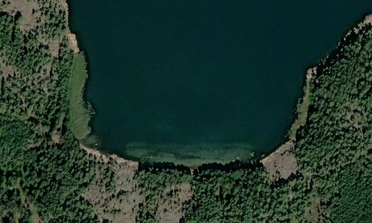
Satelite image of Skötviken

📸 Upload a photo

Show off your photos and help others plan their journey to Skötviken.harbourmaps.com is created by the sailing community, in a collective effort to make cruising simpler and more fun. Uploading a photo takes less than a minutes and can be done from your phone, tablet or laptop.

📸 Upload a photo

Facilities

We don't have any data on available facilities in this harbour. If you know which facilities are available here, please update this site to help your fellow sailors. Update facilities.

Mooring

Options for mooring in this harbour: Anchoring.

Updated on 27. Jul 2026. Update mooring.

Descriptions and reviews

Skjaldmær says:

area

maritime qualities

description

Good anchorage with sand and mud base. Anchoring depth 2-6 meters, depending on the place. More shallow in the middle in front of the sandy beach. Easy access, no surprises. Well protected from the southerly winds, but very open to the north.

1 x helpful | written on 27. Jul 2026

Do you know this harbour? It's a huge help to other sailors if you add a short description or review of the harbour.

📜 Add description

Map of Skötviken

Facilities

We don't have any data on available facilities in this harbour. If you know which facilities are available here, please update this site to help your fellow sailors. Update facilities.

Mooring

Options for mooring in this harbour: Anchoring.

Updated on 27. Jul 2026. Update mooring.

Wind protection

Protection next night

79 points

N E S W --> } } } } } } } } } } } } } } } } } } } } } } } } } } } } } } } } } } } } } } } } } } } } } } } } } } } } } } } } } } } } } } } } } } } } } } } } } } } } } } } } } } } } } } } } } } } } } } } } } } } } } } } } } } } } } } } } } } } } } } } } } } } } } } } } } } } } } } } } } } } } } } } } } } } } } } } } } } } } } } } } } } } } } } } } } } } } } } } } } } } } } } } } } } } } } } } } } } } } } } } } } } } } } } } } } } } } } } } } } } } } } } } } } } } } } } } } } } } } } } } } } } } } } } } } } } } } } } } } } } } } } } } } } } } } } } } } } } } } } } } } } } } } } } } } } } } } } } } } } } } } } } } } } } } } } } } } } } } } } } } } } } } } } } } } } } } } } } } } } } } } } } } } } } } } } } } } } } } } } } } } } } } } } } } } } } } } } } } } } } } } } } } } } } } } } } } } } } } } } } } } } } } } } } } } } } } } } } } } } } } } } } } } } } } } } } } } } } } } } } } } } } } } } } } } } } } } } } } } } } } } } } } } } } } } } } } } } } } } } } } } } } } } } } } } } } } } } } } } } } } } } } } } } } } } } } } } } } } } } } } } } } } } } } } } } } } } } } } } } } } } } } } } } } } } } } } } } } } } } } } } } } } } } } } } } } } } } } } } } } } } } } } } } } } } } } } } } } } } } } } } } } } } } } } } } } } } } } } } } } } } } } } } } } } } } } } } } } } } } } } } } } } } } } } } } } } } } } } } } } } } } } } } } } } } } } } } } } } } } } } } } } } } } } } } } } } } } } } } } } } } } } } } } } } } } } } } } } } } } } } } } } } } } } } } } } } } } } } } } } } } } } } } } } } } } } } } } } } } } } } } } } } } } } } } } } } } } } } } } } } } } } } } } } } } } } } } } } } } } } } } } } } } } } } } } } } } } } } } } } } } } } } } } } } } } } } } } } } } } } } } } } } } } } } } } } } } } } } } } } } } } } } } } } } } } } } } } } } } } } } } } } } } } } } } } } } } } } } } } } } } } } } } } } } } } } } } } } } } } } } } } } } } } } } } } } } } } } } } } } } } } } } } } } } } } } } } } } } } } } } } } } } } } } } } } } } } } } } } } } } } Next night 6:00 12:00 Lør 19 Sep 18:00 0:00 6:00 12:00 Søn 20 Sep 18:00 10m/s 6m/s

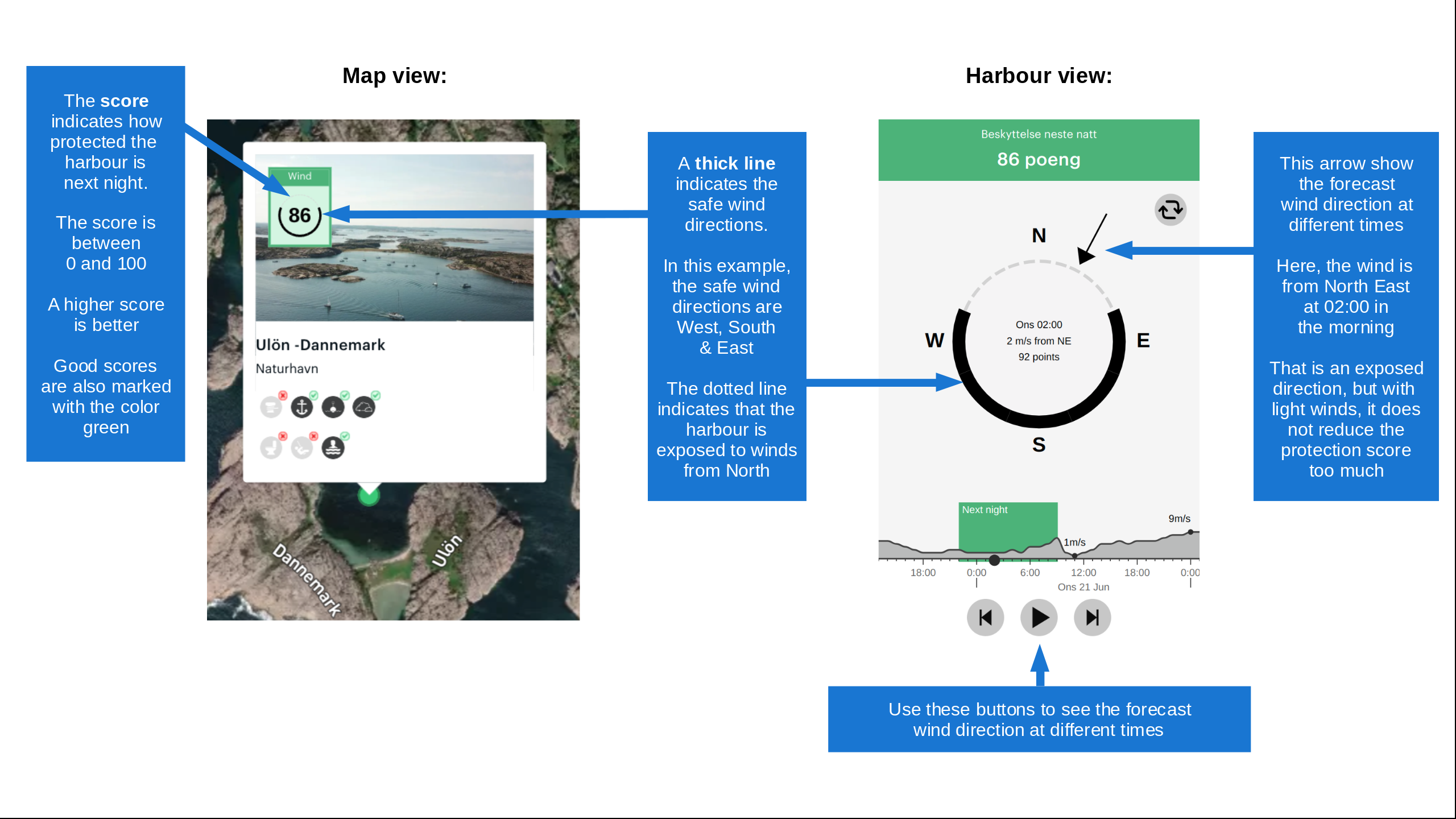
Want to know how the wind score works? Then you should read this explanation.

The wind forecasts come from yr.no (Norwegian Meteorological Institute), and was last updated 3 hours and 18 minutes ago (Saturday 19 September 05:30 AM). The next night score shows you the worst hour between 22:00 and 08:00 the next night. We recommend that you check multiple sources for wind forecasts. windy.com is a good website to show larger wind systems.

The safe wind directions for this harbour has been decided by an algorithm, based on how elevated the land around the harbour is. It's mostly correct, but sometimes the underlying data about elevation levels is not good enough to make correct decisions. It's a great help to other if you can validate or adjust the safe wind directions. You can see the data used by the algorithm to decide the safe wind directions by clicking here.

Last visits to Skötviken

The visits are retrieved from AIS data. You can click to see all visiting ships to Skötviken, as well as statistics about the ships that visits

Add this harbour to a journey

Check in now

Choose a different date than today

Important: When you check in to a harbour, you add it to a journey on this website. You are not booking a place in the marina.

Contributors

Users that contributed to this page: Skjaldmær and Marian Seppälä

harbourmaps.com is updated by the boating community. When you add information, a review or pictures to this page you are listed here with the other contributors (we list your user-name, which can be your real name or a pseudonym).

Closest harbours to Skötviken

Filter by

Natural harbour
Marina
Safe wind next night

Order by

ABC
Popularity
Wind score next night

0 harbours

Show more harbours