Våga kai (offentlig kai)

Natural harbour

favoritt

Region: Norway (3424), Rogaland (245), Karmøy (28), Røyksund (9) and Kopervik (5)

Våga kai (offentlig kai)
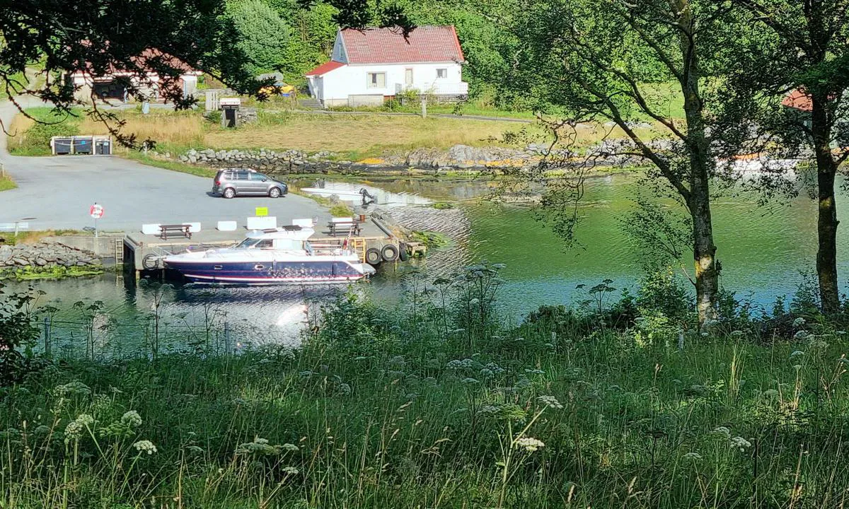
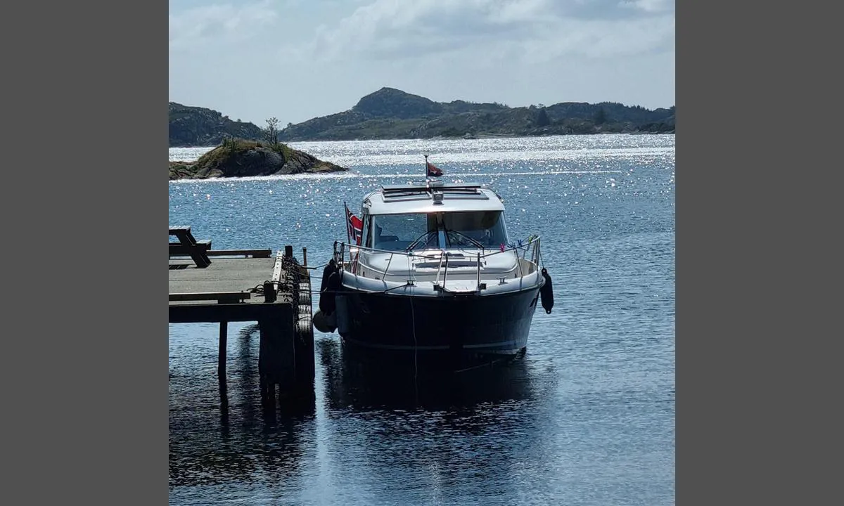
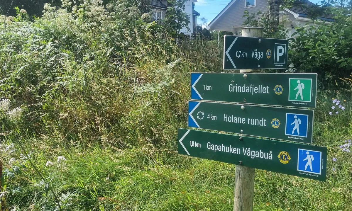
Våga kai (offentlig kai): {"base": "no", "no": "Plass til 1 b\u00e5t her. 3.5m meter dydde. Fiskemuighet. \r\n2 benker p\u00e5 kaien. Turmuligheter i omr\u00e5de.", "se": "Plats f\u00f6r 1 b\u00e5t h\u00e4r. 3,5m meter djup. Fiskem\u00f6jlighet. 2 b\u00e4nkar p\u00e5 kajen. Promenadm\u00f6jligheter i omr\u00e5det.", "en": "Room for 1 boat here. 3.5 meter depth. Fishing opportunities. 2 benches on the quay. Hiking opportunities in the area.", "da": "Plads til 1 b\u00e5d her. 3,5m meter dybde. Fiskemulighed.<br>2 b\u00e6nke p\u00e5 kajen. Turmuligheder i omr\u00e5det.", "fr": "Emplacement pour 1 bateau ici. Profondeur de 3,5 m\u00e8tres. Possibilit\u00e9 de p\u00eache.<br>2 bancs sur le quai. Possibilit\u00e9s de randonn\u00e9e dans la r\u00e9gion.", "de": "Platz f\u00fcr 1 Boot hier. 3,5 m Tiefe. Angelm\u00f6glichkeit. 2 B\u00e4nke am Kai. Wanderm\u00f6glichkeiten in der Umgebung.", "es": "Espacio para 1 barco aqu\u00ed. 3.5m metros de profundidad. Oportunidad de pesca.<br>2 bancos en el muelle. Posibilidades de hacer senderismo en la zona.", "it": "Posto per 1 barca qui. Profondit\u00e0 di 3,5m. Possibilit\u00e0 di pesca. 2 panchine sul molo. Possibilit\u00e0 di escursioni nella zona.", "pt": "Lugar para 1 barco aqui. Profundidade de 3,5 m. Possibilidade de pesca. 2 bancos no cais. Possibilidades de passeio na \u00e1rea.", "nl": "Plaats voor 1 boot hier. 3,5m diepte. Visgelegenheid. 2 banken op de kade. Wandermogelijkheden in de omgeving.", "pl": "Miejsce na 1 \u0142\u00f3d\u017a tutaj. G\u0142\u0119boko\u015b\u0107 3,5 metra. Mo\u017cliwo\u015b\u0107 \u0142owienia ryb. 2 \u0142awki na nabrze\u017cu. Mo\u017cliwo\u015bci wycieczek w okolicy.", "uk": "\u041c\u0456\u0441\u0446\u0435 \u043d\u0430 1 \u0447\u043e\u0432\u0435\u043d \u0442\u0443\u0442. \u0413\u043b\u0438\u0431\u0438\u043d\u0430 3,5 \u043c\u0435\u0442\u0440\u0438. \u041c\u043e\u0436\u043b\u0438\u0432\u0456\u0441\u0442\u044c \u0440\u0438\u0431\u043e\u043b\u043e\u0432\u043b\u0456. 2 \u043b\u0430\u0432\u043a\u0438 \u043d\u0430 \u043f\u0440\u0438\u0447\u0430\u043b\u0456. \u041c\u043e\u0436\u043b\u0438\u0432\u043e\u0441\u0442\u0456 \u0434\u043b\u044f \u043f\u0440\u043e\u0433\u0443\u043b\u044f\u043d\u043e\u043a \u0432 \u043e\u043a\u043e\u043b\u0438\u0446\u044f\u0445.", "ro": "Loc pentru 1 barc\u0103 aici. Ad\u00e2ncime de 3,5m. Posibilitate de pescuit. 2 b\u0103nci pe cheu. Posibilit\u0103\u021bi de plimbare \u00een zon\u0103.", "tr": "Burada 1 tekne i\u00e7in yer var. 3,5 metre derinlik. Bal\u0131k\u00e7\u0131l\u0131k imkan\u0131. \u0130skelenin \u00fczerinde 2 bank. B\u00f6lgedeki y\u00fcr\u00fcy\u00fc\u015f yollar\u0131.", "el": "\u03a7\u03ce\u03c1\u03bf\u03c2 \u03b3\u03b9\u03b1 1 \u03c3\u03ba\u03ac\u03c6\u03bf\u03c2 \u03b5\u03b4\u03ce. 3,5\u03bc \u03b2\u03ac\u03b8\u03bf\u03c2. \u0394\u03c5\u03bd\u03b1\u03c4\u03cc\u03c4\u03b7\u03c4\u03b1 \u03c8\u03b1\u03c1\u03ad\u03bc\u03b1\u03c4\u03bf\u03c2. 2 \u03c0\u03ac\u03b3\u03ba\u03bf\u03b9 \u03c3\u03c4\u03b7\u03bd \u03c0\u03c1\u03bf\u03ba\u03c5\u03bc\u03b1\u03af\u03b1. \u0394\u03c5\u03bd\u03b1\u03c4\u03cc\u03c4\u03b7\u03c4\u03b5\u03c2 \u03c0\u03b5\u03b6\u03bf\u03c0\u03bf\u03c1\u03af\u03b1\u03c2 \u03c3\u03c4\u03b7\u03bd \u03c0\u03b5\u03c1\u03b9\u03bf\u03c7\u03ae.", "cs": "M\u00edsto pro 1 lo\u010f zde. Hloubka 3,5 m. Mo\u017enost rybolovu.<br>2 lavi\u010dky na molu. Mo\u017enosti v\u00fdlet\u016f v okol\u00ed.", "hu": "Egy haj\u00f3 sz\u00e1m\u00e1ra van hely itt. 3,5 m\u00e9ter m\u00e9ly. Horg\u00e1sz\u00e1si lehet\u0151s\u00e9g.<br/>2 pad tal\u00e1lhat\u00f3 a m\u00f3l\u00f3n. T\u00far\u00e1z\u00e1si lehet\u0151s\u00e9gek a k\u00f6rny\u00e9ken.", "fi": "Paikka yhdelle veneelle t\u00e4\u00e4ll\u00e4. Syvyys 3,5 metri\u00e4. Kalastusmahdollisuus. 2 penkki\u00e4 laiturilla. Retkeilymahdollisuuksia alueella.", "bg": "\u041c\u044f\u0441\u0442\u043e \u0437\u0430 1 \u043b\u043e\u0434\u043a\u0430 \u0442\u0443\u043a. 3.5 \u043c\u0435\u0442\u0440\u0430 \u0434\u044a\u043b\u0431\u043e\u0447\u0438\u043d\u0430. \u0412\u044a\u0437\u043c\u043e\u0436\u043d\u043e\u0441\u0442 \u0437\u0430 \u0440\u0438\u0431\u043e\u043b\u043e\u0432. 2 \u043f\u0435\u0439\u043a\u0438 \u043d\u0430 \u043a\u0435\u044f. \u0412\u044a\u0437\u043c\u043e\u0436\u043d\u043e\u0441\u0442\u0438 \u0437\u0430 \u0440\u0430\u0437\u0445\u043e\u0434\u043a\u0430 \u0432 \u0440\u0430\u0439\u043e\u043d\u0430.", "sr": "Mesto za jedan brod ovde. Dubina 3.5 metara. Mogu\u0107nost ribolova. 2 klupe na pristani\u0161tu. Mogu\u0107nosti za izlete u okolini.", "et": "Koht 1 laevale siin. 3.5m s\u00fcgavus. Kalap\u00fc\u00fcgi v\u00f5imalus. 2 pinki kail. Matkamisv\u00f5imalused piirkonnas.", "lv": "Vieta 1 laivai \u0161eit. 3,5 metri dzi\u013cums. Mak\u0161\u0137er\u0113\u0161anas iesp\u0113jas. 2 soli\u0146i uz piest\u0101tnes. Iesp\u0113jas p\u0101rg\u0101jieniem apk\u0101rtn\u0113.", "lt": "Vieta 1 laivui \u010dia. 3,5 m gylis. \u017dvejybos galimyb\u0117. 2 suolai prieplaukoje. Ekskursijos galimyb\u0117s apylink\u0117se."}
Våga kai (offentlig kai): {"base": "no", "no": "Turer i omr\u00e5de", "se": "Utflykter i omr\u00e5det", "en": "Trips in the area", "da": "Ture i omr\u00e5det", "fr": "Excursions dans la r\u00e9gion", "de": "Touren in der Umgebung", "es": "Excursiones en la zona", "it": "Escursioni nella zona", "pt": "Passeios na \u00e1rea", "nl": "Tochten in de omgeving", "pl": "Wycieczki w okolicy", "uk": "\u0422\u0443\u0440\u0438 \u0432 \u0440\u0430\u0439\u043e\u043d\u0456", "ro": "Excursii \u00een zon\u0103", "tr": "B\u00f6lgedeki turlar", "el": "\u03a0\u03b5\u03c1\u03b9\u03b7\u03b3\u03ae\u03c3\u03b5\u03b9\u03c2 \u03c3\u03c4\u03b7\u03bd \u03c0\u03b5\u03c1\u03b9\u03bf\u03c7\u03ae", "cs": "V\u00fdlety v oblasti", "hu": "Kir\u00e1ndul\u00e1sok a k\u00f6rny\u00e9ken", "fi": "Retket alueella", "bg": "\u0415\u043a\u0441\u043a\u0443\u0440\u0437\u0438\u0438 \u0432 \u0440\u0430\u0439\u043e\u043d\u0430", "sr": "\u041f\u0443\u0442\u043e\u0432\u0430\u045a\u0430 \u0443 \u043e\u0431\u043b\u0430\u0441\u0442\u0438", "et": "Ekskursioonid piirkonnas", "lv": "Ekskursijas apk\u0101rtn\u0113", "lt": "Ekskursijos \u0161iame regione"}
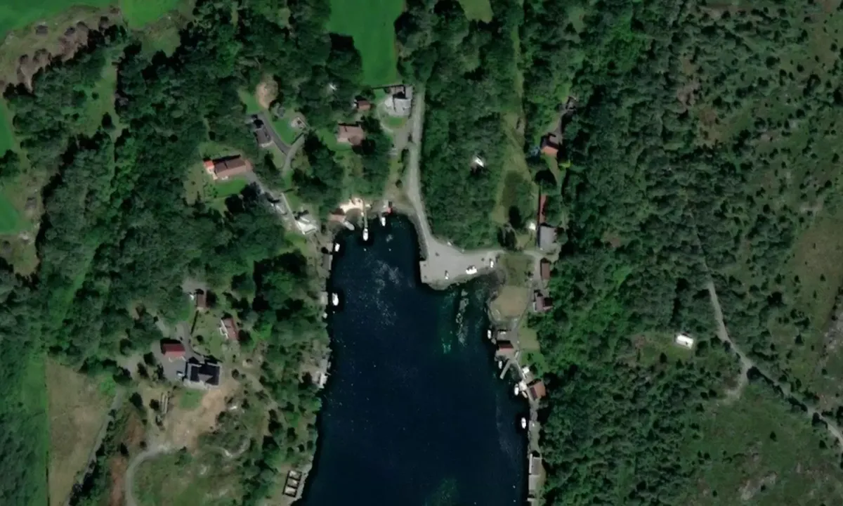
Satelite image of Våga kai (offentlig kai)

📸 Upload a photo

Show off your photos and help others plan their journey to Våga kai (offentlig kai).harbourmaps.com is created by the sailing community, in a collective effort to make cruising simpler and more fun. Uploading a photo takes less than a minutes and can be done from your phone, tablet or laptop.

📸 Upload a photo

Facilities

We don't have any data on available facilities in this harbour. If you know which facilities are available here, please update this site to help your fellow sailors. Update facilities.

Mooring

Options for mooring in this harbour: To pier/wharf.

Updated on 30. Jul 2025. Update mooring.

Descriptions and reviews

Per Arne Primstad says:

area

maritime qualities

description

Public quay. Space for 1 boat. 3.5 meters depth. 2 benches on the quay. Well sheltered from all winds except the south.

[translated from Norwegian with AI]

1 x helpful | written on 29. Jul 2025

Do you know this harbour? It's a huge help to other sailors if you add a short description or review of the harbour.

📜 Add description

Map of Våga kai (offentlig kai)

Facilities

We don't have any data on available facilities in this harbour. If you know which facilities are available here, please update this site to help your fellow sailors. Update facilities.

Mooring

Options for mooring in this harbour: To pier/wharf.

Updated on 30. Jul 2025. Update mooring.

Wind protection

Protection next night

86 points

N E S W --> } } } } } } } } } } } } } } } } } } } } } } } } } } } } } } } } } } } } } } } } } } } } } } } } } } } } } } } } } } } } } } } } } } } } } } } } } } } } } } } } } } } } } } } } } } } } } } } } } } } } } } } } } } } } } } } } } } } } } } } } } } } } } } } } } } } } } } } } } } } } } } } } } } } } } } } } } } } } } } } } } } } } } } } } } } } } } } } } } } } } } } } } } } } } } } } } } } } } } } } } } } } } } } } } } } } } } } } } } } } } } } } } } } } } } } } } } } } } } } } } } } } } } } } } } } } } } } } } } } } } } } } } } } } } } } } } } } } } } } } } } } } } } } } } } } } } } } } } } } } } } } } } } } } } } } } } } } } } } } } } } } } } } } } } } } } } } } } } } } } } } } } } } } } } } } } } } } } } } } } } } } } } } } } } } } } } } } } } } } } } } } } } } } } } } } } } } } } } } } } } } } } } } } } } } } } } } } } } } } } } } } } } } } } } } } } } } } } } } } } } } } } } } } } } } } } } } } } } } } } } } } } } } } } } } } } } } } } } } } } } } } } } } } } } } } } } } } } } } } } } } } } } } } } } } } } } } } } } } } } } } } } } } } } } } } } } } } } } } } } } } } } } } } } } } } } } } } } } } } } } } } } } } } } } } } } } } } } } } } } } } } } } } } } } } } } } } } } } } } } } } } } } } } } } } } } } } } } } } } } } } } } } } } } } } } } } } } } } } } } } } } } } } } } } } } } } } } } } } } } } } } } } } } } } } } } } } } } } } } } } } } } } } } } } } } } } } } } } } } } } } } } } } } } } } } } } } } } } } } } } } } } } } } } } } } } } } } } } } } } } } } } } } } } } } } } } } } } } } } } } } } } } } } } } } } } } } } } } } } } } } } } } } } } } } } } } } } } } } } } } } } } } } } } } } } } } } } } } } } } } } } } } } } } } } } } } } } } } } } } } } } } } } } } } } } } } } } } } } } } } } } } } } } } } } } } } } } } } } } } } } } } } } } } } } } } } } } } } } } } } } } } } } } } } } } } } } } } } } } } } } } } } } } } } } } } } } } } } } } } } } } } } } } } } } } } } } } } } } } } } } } } } } } } } } } } } } } } } } } } } Next night 0:00 6:00 12:00 Ons 17 Sep 18:00 0:00 6:00 7m/s 1m/s

Want to know how the wind score works? Then you should read this explanation.

The wind forecasts come from yr.no (Norwegian Meteorological Institute), and was last updated 1 hour and 12 minutes ago (Tuesday 16 September 11:26 PM). The next night score shows you the worst hour between 22:00 and 08:00 the next night. We recommend that you check multiple sources for wind forecasts. windy.com is a good website to show larger wind systems.

The safe directions for this harbour was added at 30. Jul 2025. Click here to edit.

Last visits to Våga kai (offentlig kai)

The visits are retrieved from AIS data. You can click to see all visiting ships to Våga kai (offentlig kai), as well as statistics about the ships that visits

Add this harbour to a journey

Check in now

Choose a different date than today

Important: When you check in to a harbour, you add it to a journey on this website. You are not booking a place in the marina.

Contributors

Users that contributed to this page: Per Arne Primstad

harbourmaps.com is updated by the boating community. When you add information, a review or pictures to this page you are listed here with the other contributors (we list your user-name, which can be your real name or a pseudonym).

Closest harbours to Våga kai (offentlig kai)

Filter by

Natural harbour
Marina
Safe wind next night

Order by

ABC
Popularity
Wind score next night

0 harbours

Show more harbours