









































Vinjesjøen Båthavn

Marina

favoritt

Region: Norway (3487), Nordland (680), Vesterålen (119) and Bø (19)

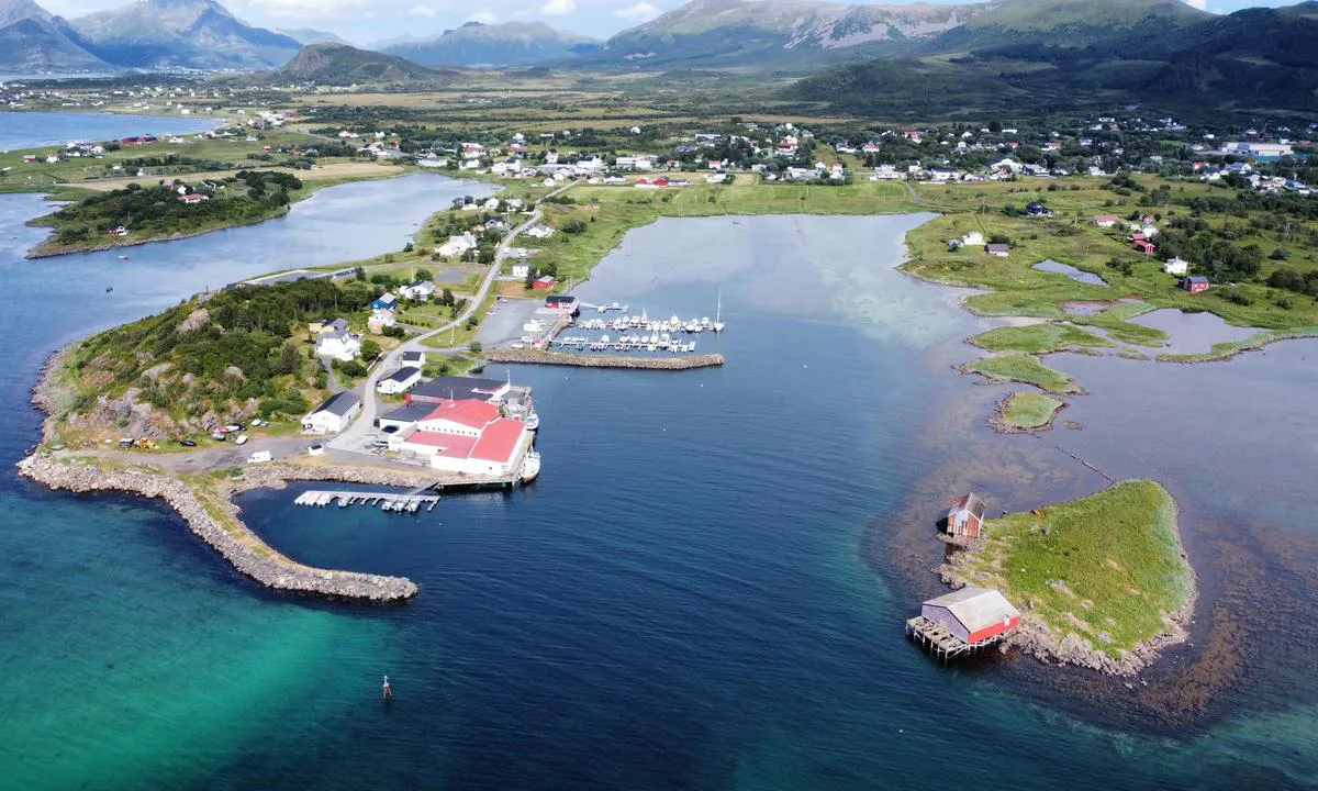
Vinjesjøen Båthavn: {"base": "no", "no": "Her ser man innseilingen", "se": "H\u00e4r ser man inseglingen", "en": "Here you can see the approach", "da": "Her ser man indsejlingen"}
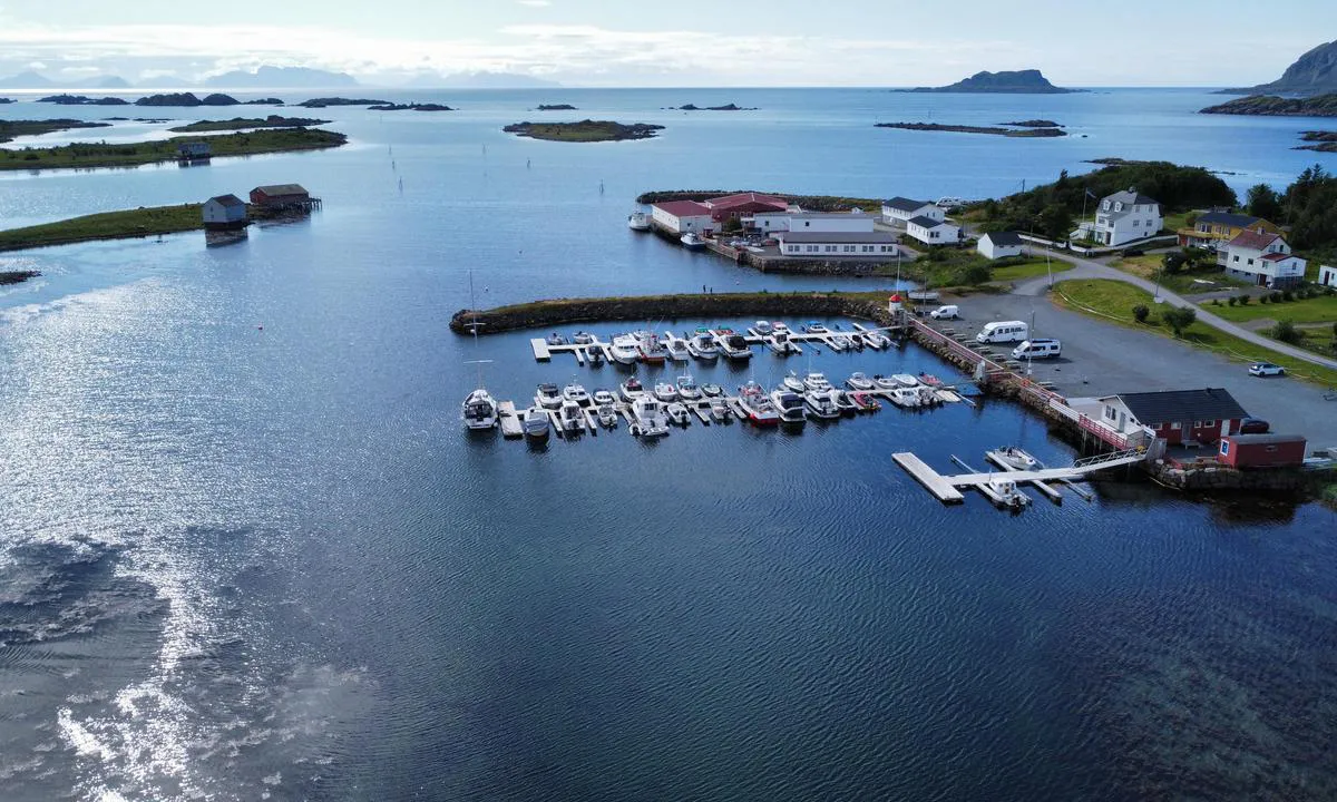
Vinjesjøen Båthavn: {"base": "no", "no": "Den innerste korte bryggen er egentlig gjestekai, men usikker p\u00e5 dybden der inne.", "se": "Den innersta korta bryggan \u00e4r egentligen en g\u00e4stkaj, men os\u00e4ker p\u00e5 djupet d\u00e4r inne.", "en": "The innermost short pier is actually a guest quay, but the depth there is uncertain.", "da": "Den inderste korte bro er egentlig g\u00e6stekaj, men usikker p\u00e5 dybden derinde."}
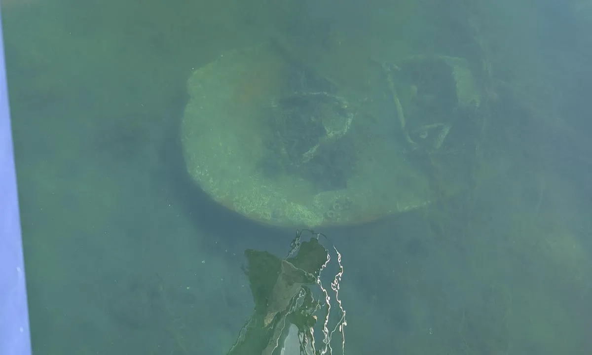
Vinjesjøen Båthavn: {"base": "en", "no": "P\u00e5 den s\u00f8rlige enden av den nye (2015) hammerhodepontongen ligger det som ser ut som kassert fiskeutstyr (bunntr\u00e5lbord?) p\u00e5 bunnen, med omtrent bare 2,25m over ved lavvann. Det stikker ut omtrent 4-5m fra pontongen. Dette bildet ble tatt med blikket mot s\u00f8r. I tillegg er kjettingene p\u00e5 den nordlige enden av pontongen n\u00e6rmere overflaten, antageligvis fordi det er noe grunnere her.", "se": "Vid den s\u00f6dra \u00e4nden av den nya (2015) T-bryggan finns n\u00e5got som ser ut att vara \u00f6vergivet fiskeutrustning (sitterplanka?) liggande p\u00e5 botten med cirka endast 2,25m \u00f6ver det vid LW. Det sticker ut cirka 4-5m fr\u00e5n bryggan. Detta foto togs s\u00f6derut.\nDessutom \u00e4r kedjorna vid den norra \u00e4nden av bryggan n\u00e4rmare ytan, f\u00f6rmodligen eftersom det \u00e4r n\u00e5got grundare h\u00e4r.", "en": "At the southern end of the new (2015) hammerhead pontoon there is what looks to be discarded fishing equipment (otter board?) lying on the bottom with approx only 2.25m over it at LW. It protrudes approx 4-5m from the pontoon. This photo was taken looking South.\r\nAdditionally the chains at the North end of the pontoon are closer to the surface, presumably as it's somewhat shallower here.", "da": "Ved den sydlige ende af den nye (2015) hammerhoved-ponton ligger der, hvad der ser ud til at v\u00e6re kasseret fiskeudstyr (odderplade?) p\u00e5 bunden, med kun ca. 2,25m over det ved lavvande. Det stikker ca. 4-5m ud fra pontonen. Dette foto blev taget med udsigt mod syd. Derudover er k\u00e6derne ved den nordlige ende af pontonen t\u00e6ttere p\u00e5 overfladen, formodentlig fordi det er noget mere lavvandet her.", "fr": "\u00c0 l'extr\u00e9mit\u00e9 sud du nouveau (2015) ponton en T, il semblerait qu'il y ait du mat\u00e9riel de p\u00eache abandonn\u00e9 (planche \u00e0 loutre ?) au fond avec environ seulement 2,25 m au-dessus \u00e0 mar\u00e9e basse. Il d\u00e9passe d'environ 4-5 m du ponton. Cette photo a \u00e9t\u00e9 prise en regardant vers le sud. De plus, les cha\u00eenes \u00e0 l'extr\u00e9mit\u00e9 nord du ponton sont plus proches de la surface, probablement parce que c'est un peu moins profond ici.", "de": "Am s\u00fcdlichen Ende des neuen (2015) Hammerkopf-Pontons befindet sich, was wie weggeworfenes Fischereiger\u00e4t (Otterbrett?) aussieht, das am Grund liegt, mit nur ca. 2,25 m Wasser \u00fcber ihm bei Niedrigwasser. Es ragt ca. 4-5 m vom Ponton heraus. Dieses Foto wurde in s\u00fcdlicher Richtung aufgenommen. Zus\u00e4tzlich sind die Ketten am n\u00f6rdlichen Ende des Pontons n\u00e4her an der Oberfl\u00e4che, vermutlich weil es hier etwas seichter ist.", "es": "En el extremo sur del nuevo (2015) pantal\u00e1n hammerhead hay lo que parece ser equipo de pesca descartado (tabla otter?) tirado en el fondo con aproximadamente solo 2.25m sobre \u00e9l en Marea Baja. Sobresale aproximadamente 4-5m desde el pantal\u00e1n. Esta foto fue tomada mirando hacia el Sur.<br>Adem\u00e1s, las cadenas en el extremo Norte del pantal\u00e1n est\u00e1n m\u00e1s cerca de la superficie, presumiblemente porque es algo m\u00e1s superficial aqu\u00ed.", "it": "All'estremit\u00e0 sud del nuovo (2015) pontile a martello sembra esserci dell'attrezzatura da pesca scartata (tavola dell'otter?) che giace sul fondo con circa solo 2,25 m sopra di essa a bassa marea. Sporge di circa 4-5 m dal pontile. Questa foto \u00e8 stata scattata guardando verso sud. Inoltre, le catene all'estremit\u00e0 nord del pontile sono pi\u00f9 vicine alla superficie, presumibilmente perch\u00e9 qui \u00e8 un po' pi\u00f9 superficiale.", "pt": "Na extremidade sul do novo (2015) pont\u00e3o de cabe\u00e7a de martelo, h\u00e1 o que parece ser equipamento de pesca descartado (prancha de arrasto?) no fundo, com aproximadamente apenas 2,25m sobre ele na mar\u00e9 baixa. Ele se projeta aproximadamente 4-5m do pont\u00e3o. Esta foto foi tirada olhando para o sul. Al\u00e9m disso, as correntes na extremidade norte do pont\u00e3o est\u00e3o mais pr\u00f3ximas da superf\u00edcie, presumivelmente porque \u00e9 um pouco mais raso aqui.", "nl": "Aan het zuidelijke uiteinde van de nieuwe (2015) hammerhead-ponton ligt er ogenschijnlijk afgedankte visuitrusting (otterbord?) op de bodem met ongeveer slechts 2,25m eroverheen bij laagwater. Het steekt ongeveer 4-5m uit vanaf de ponton. Deze foto is genomen met zicht naar het zuiden. Bovendien liggen de kettingen aan het noordelijke uiteinde van de ponton dichter bij het oppervlak, vermoedelijk omdat het hier wat ondieper is.", "pl": "Na po\u0142udniowym ko\u0144cu nowego (2015) pomostu w kszta\u0142cie m\u0142otka znajduje si\u0119 porzucony sprz\u0119t rybacki (p\u0142yta dennica?) le\u017c\u0105cy na dnie, z ok. 2,25 m wody nad nim przy niskiej wodzie. Wystaje on na ok. 4-5 m od pomostu. To zdj\u0119cie zosta\u0142o wykonane z widokiem na po\u0142udnie. <br> Dodatkowo \u0142a\u0144cuchy na p\u00f3\u0142nocnym ko\u0144cu pomostu znajduj\u0105 si\u0119 bli\u017cej powierzchni, przypuszczalnie z powodu p\u0142ytszej wody w tym miejscu.", "uk": "\u041d\u0430 \u043f\u0456\u0432\u0434\u0435\u043d\u043d\u043e\u043c\u0443 \u043a\u0440\u0430\u044e \u043d\u043e\u0432\u043e\u0433\u043e (2015) \u043f\u043e\u043d\u0442\u043e\u043d\u0443 \u0437 \u043c\u043e\u043b\u043e\u0442\u043e\u043c \u0437\u043d\u0430\u0445\u043e\u0434\u0438\u0442\u044c\u0441\u044f, \u0441\u0445\u043e\u0436\u0435, \u0432\u0438\u043a\u0438\u043d\u0443\u0442\u0435 \u0440\u0438\u0431\u043e\u043b\u043e\u0432\u043d\u0435 \u043e\u0431\u043b\u0430\u0434\u043d\u0430\u043d\u043d\u044f (\u043f\u043b\u0430\u043d\u0435\u0440?), \u0449\u043e \u043b\u0435\u0436\u0438\u0442\u044c \u043d\u0430 \u0434\u043d\u0456, \u0437 \u043f\u0440\u0438\u0431\u043b\u0438\u0437\u043d\u043e \u043b\u0438\u0448\u0435 2,25 \u043c \u043d\u0430\u0434 \u043d\u0438\u043c \u043f\u0440\u0438 \u043d\u0438\u0437\u044c\u043a\u043e\u043c\u0443 \u0440\u0456\u0432\u043d\u0456 \u0432\u043e\u0434\u0438. \u0412\u043e\u043d\u043e \u0432\u0438\u0441\u0442\u0443\u043f\u0430\u0454 \u043f\u0440\u0438\u0431\u043b\u0438\u0437\u043d\u043e \u043d\u0430 4-5 \u043c \u0432\u0456\u0434 \u043f\u043e\u043d\u0442\u043e\u043d\u0443. \u0426\u0435 \u0444\u043e\u0442\u043e \u0431\u0443\u043b\u043e \u0437\u0440\u043e\u0431\u043b\u0435\u043d\u043e, \u0434\u0438\u0432\u043b\u044f\u0447\u0438\u0441\u044c \u043d\u0430 \u041f\u0456\u0432\u0434\u0435\u043d\u044c. <br> \u041a\u0440\u0456\u043c \u0442\u043e\u0433\u043e, \u043b\u0430\u043d\u0446\u044e\u0433\u0438 \u043d\u0430 \u043f\u0456\u0432\u043d\u0456\u0447\u043d\u043e\u043c\u0443 \u043a\u0440\u0430\u044e \u043f\u043e\u043d\u0442\u043e\u043d\u0443 \u0431\u043b\u0438\u0436\u0447\u0435 \u0434\u043e \u043f\u043e\u0432\u0435\u0440\u0445\u043d\u0456, \u0439\u043c\u043e\u0432\u0456\u0440\u043d\u043e, \u0442\u043e\u043c\u0443 \u0449\u043e \u0442\u0443\u0442 \u0442\u0440\u043e\u0445\u0438 \u043c\u0456\u043b\u043a\u0456\u0448\u0435.", "ro": "La cap\u0103tul sudic al noului ponton cu cap de ciocan (2015) se afl\u0103 un echipament de pescuit ce pare a fi abandonat (plas\u0103 pentru pe\u0219te?), situat pe fund cu aproximativ numai 2,25 m deasupra la LB. Acesta iese aproximativ 4-5 m de la ponton. Aceast\u0103 fotografie a fost f\u0103cut\u0103 cu vedere spre sud. \u00cen plus, lan\u021burile de la cap\u0103tul nordic al pontonului sunt mai aproape de suprafa\u021b\u0103, probabil deoarece aici este ceva mai pu\u021bin ad\u00e2nc.", "tr": "Yeni (2015) \u00e7eki\u00e7 ba\u015f\u0131 iskelenin g\u00fcney ucunda, dipte terkedilmi\u015f gibi g\u00f6r\u00fcnen (bal\u0131k\u00e7\u0131 trol tahtas\u0131?) ekipman var, en d\u00fc\u015f\u00fck su seviyesinde (ELS) \u00fczerinde yakla\u015f\u0131k sadece 2,25m derinlikte durmaktad\u0131r. \u0130skelenin yakla\u015f\u0131k 4-5 metre d\u0131\u015f\u0131na ta\u015fmaktad\u0131r. Bu foto\u011fraf g\u00fcney y\u00f6n\u00fcne bak\u0131larak \u00e7ekilmi\u015ftir. Ek olarak, iskelenin kuzey ucundaki zincirler y\u00fczeye daha yak\u0131nd\u0131r, muhtemelen buras\u0131 biraz daha s\u0131\u011f oldu\u011fundan dolay\u0131.", "el": "\u03a3\u03c4\u03bf \u03bd\u03cc\u03c4\u03b9\u03bf \u03ac\u03ba\u03c1\u03bf \u03c4\u03b7\u03c2 \u03bd\u03ad\u03b1\u03c2 (2015) \u03c0\u03c1\u03bf\u03b2\u03bb\u03ae\u03c4\u03b1\u03c2 \u03c4\u03cd\u03c0\u03bf\u03c5 \u03c3\u03c6\u03c5\u03c1\u03bf\u03ba\u03ad\u03c6\u03b1\u03bb\u03bf\u03c5 \u03c5\u03c0\u03ac\u03c1\u03c7\u03b5\u03b9 \u03ba\u03ac\u03c4\u03b9 \u03c0\u03bf\u03c5 \u03c6\u03b1\u03af\u03bd\u03b5\u03c4\u03b1\u03b9 \u03bd\u03b1 \u03b5\u03af\u03bd\u03b1\u03b9 \u03b5\u03b3\u03ba\u03b1\u03c4\u03b1\u03bb\u03b5\u03b9\u03bc\u03bc\u03ad\u03bd\u03bf\u03c2 \u03b1\u03bb\u03b9\u03b5\u03c5\u03c4\u03b9\u03ba\u03cc\u03c2 \u03b5\u03be\u03bf\u03c0\u03bb\u03b9\u03c3\u03bc\u03cc\u03c2 (\u03b9\u03c3\u03c4\u03af\u03b1 \u03c4\u03cd\u03c0\u03bf\u03c5 otter board?) \u03c0\u03bf\u03c5 \u03b2\u03c1\u03af\u03c3\u03ba\u03b5\u03c4\u03b1\u03b9 \u03c3\u03c4\u03bf\u03bd \u03c0\u03c5\u03b8\u03bc\u03ad\u03bd\u03b1 \u03bc\u03b5 \u03c0\u03b5\u03c1\u03af\u03c0\u03bf\u03c5 \u03bc\u03cc\u03bd\u03bf 2,25\u03bc \u03b1\u03c0\u03cc \u03c0\u03ac\u03bd\u03c9 \u03c4\u03bf\u03c5 \u03c3\u03c4\u03bf \u03c7\u03b1\u03bc\u03b7\u03bb\u03cc\u03c4\u03b5\u03c1\u03bf \u03c3\u03b7\u03bc\u03b5\u03af\u03bf \u03c4\u03b7\u03c2 \u03c0\u03b1\u03bb\u03af\u03c1\u03c1\u03bf\u03b9\u03b1\u03c2 (LW). \u03a0\u03c1\u03bf\u03b5\u03be\u03ad\u03c7\u03b5\u03b9 \u03c0\u03b5\u03c1\u03af\u03c0\u03bf\u03c5 4-5\u03bc \u03b1\u03c0\u03cc \u03c4\u03b7\u03bd \u03c0\u03c1\u03bf\u03b2\u03bb\u03ae\u03c4\u03b1. \u0391\u03c5\u03c4\u03ae \u03b7 \u03c6\u03c9\u03c4\u03bf\u03b3\u03c1\u03b1\u03c6\u03af\u03b1 \u03c4\u03c1\u03b1\u03b2\u03ae\u03c7\u03c4\u03b7\u03ba\u03b5 \u03ba\u03bf\u03b9\u03c4\u03ac\u03b6\u03bf\u03bd\u03c4\u03b1\u03c2 \u03c0\u03c1\u03bf\u03c2 \u03c4\u03bf\u03bd \u039d\u03cc\u03c4\u03bf. \u0395\u03c0\u03b9\u03c0\u03bb\u03ad\u03bf\u03bd, \u03bf\u03b9 \u03b1\u03bb\u03c5\u03c3\u03af\u03b4\u03b5\u03c2 \u03c3\u03c4\u03bf \u03b2\u03cc\u03c1\u03b5\u03b9\u03bf \u03ac\u03ba\u03c1\u03bf \u03c4\u03b7\u03c2 \u03c0\u03c1\u03bf\u03b2\u03bb\u03ae\u03c4\u03b1\u03c2 \u03b5\u03af\u03bd\u03b1\u03b9 \u03c0\u03b9\u03bf \u03ba\u03bf\u03bd\u03c4\u03ac \u03c3\u03c4\u03b7\u03bd \u03b5\u03c0\u03b9\u03c6\u03ac\u03bd\u03b5\u03b9\u03b1, \u03c0\u03c1\u03bf\u03c6\u03b1\u03bd\u03ce\u03c2 \u03b5\u03c0\u03b5\u03b9\u03b4\u03ae \u03c4\u03bf \u03b2\u03ac\u03b8\u03bf\u03c2 \u03b5\u03af\u03bd\u03b1\u03b9 \u03ba\u03ac\u03c0\u03c9\u03c2 \u03bc\u03b9\u03ba\u03c1\u03cc\u03c4\u03b5\u03c1\u03bf \u03b5\u03b4\u03ce.", "cs": "Na ji\u017en\u00edm konci nov\u00e9ho (2015) hammerhead pontonu se nach\u00e1z\u00ed vybaven\u00ed, kter\u00e9 vypad\u00e1 jako odhozen\u00e9 ryb\u00e1\u0159sk\u00e9 pot\u0159eby (taha\u010d s\u00edt\u00ed?), le\u017e\u00edc\u00ed na dn\u011b s hloubkou p\u0159ibli\u017en\u011b pouze 2,25 m nad n\u00edm za n\u00edzk\u00e9 vody. Vystupuje p\u0159ibli\u017en\u011b 4-5 m od pontonu. Tato fotografie byla po\u0159\u00edzena sm\u011brem na jih.<br> D\u00e1le jsou \u0159et\u011bzy na severn\u00edm konci pontonu bl\u00ed\u017ee k hladin\u011b, pravd\u011bpodobn\u011b proto, \u017ee je zde pon\u011bkud m\u011bl\u010d\u00ed.", "hu": "Az \u00faj (2015) kalap\u00e1csfej m\u00f3l\u00f3 d\u00e9li v\u00e9g\u00e9n\u00e9l \u00fagy t\u0171nik, hogy kidobott hal\u00e1szati felszerel\u00e9s (vontat\u00f3t\u00e1bla?) fekszik az alj\u00e1n, amely felett kb. csak 2,25 m\u00e9ter van ap\u00e1lykor. Ez kb. 4-5 m\u00e9terre kiny\u00falik a m\u00f3l\u00f3t\u00f3l. Ez a fot\u00f3 d\u00e9l fel\u00e9 n\u00e9zve k\u00e9sz\u00fclt. Ezenk\u00edv\u00fcl a m\u00f3l\u00f3 \u00e9szaki v\u00e9g\u00e9n l\u00e9v\u0151 l\u00e1ncok k\u00f6zelebb vannak a felsz\u00ednhez, felt\u00e9telezhet\u0151en az\u00e9rt, mert itt valamivel sek\u00e9lyebb a v\u00edz.", "fi": "Uuden (2015) hammerhead-laiturin etel\u00e4p\u00e4\u00e4ss\u00e4 on pohjalla hyl\u00e4tyksi vaikutelmaksi j\u00e4tetty\u00e4 kalastusv\u00e4lineist\u00f6\u00e4 (potkuri tms.), jonka yl\u00e4puolella vett\u00e4 on alimmillaan vain noin 2,25 metri\u00e4. Se ulkonee laiturista noin 4-5 metri\u00e4. T\u00e4m\u00e4 valokuva on otettu etel\u00e4\u00e4n p\u00e4in. Lis\u00e4ksi laiturin pohjoisp\u00e4\u00e4n ketjut ovat l\u00e4hemp\u00e4n\u00e4 pintaa, todenn\u00e4k\u00f6isesti koska t\u00e4ss\u00e4 kohtaa on hieman matalampaa.", "bg": "\u0412 \u044e\u0436\u043d\u0438\u044f \u043a\u0440\u0430\u0439 \u043d\u0430 \u043d\u043e\u0432\u0438\u044f (2015 \u0433.) \u043a\u0435\u0439-\u0431\u043e\u043d\u0431\u043e\u043d\u0438 \u0438\u043c\u0430 \u0438\u0437\u0445\u0432\u044a\u0440\u043b\u0435\u043d\u0438 \u0440\u0438\u0431\u043e\u043b\u043e\u0432\u043d\u0438 \u0441\u044a\u043e\u0440\u044a\u0436\u0435\u043d\u0438\u044f (\u0440\u0438\u0431\u043e\u043b\u043e\u0432\u043d\u0430 \u0434\u044a\u0441\u043a\u0430?), \u043a\u043e\u0438\u0442\u043e \u043b\u0435\u0436\u0430\u0442 \u043d\u0430 \u0434\u044a\u043d\u043e\u0442\u043e, \u043a\u0430\u0442\u043e \u043d\u0430\u0434 \u0442\u044f\u0445 \u0438\u043c\u0430 \u043f\u0440\u0438\u0431\u043b\u0438\u0437\u0438\u0442\u0435\u043b\u043d\u043e \u0441\u0430\u043c\u043e 2.25 \u043c \u043f\u0440\u0438 \u043d\u0438\u0441\u043a\u0430 \u0432\u043e\u0434\u0430 (LW). \u0422\u0435 \u0441\u0442\u044a\u0440\u0447\u0430\u0442 \u043f\u0440\u0438\u0431\u043b\u0438\u0437\u0438\u0442\u0435\u043b\u043d\u043e 4-5 \u043c \u043e\u0442 \u043a\u0435\u044f. \u0422\u0430\u0437\u0438 \u0441\u043d\u0438\u043c\u043a\u0430 \u0435 \u043d\u0430\u043f\u0440\u0430\u0432\u0435\u043d\u0430 \u0441 \u0433\u043b\u0435\u0434\u043a\u0430 \u043d\u0430 \u044e\u0433. \u0414\u043e\u043f\u044a\u043b\u043d\u0438\u0442\u0435\u043b\u043d\u043e, \u0432\u0435\u0440\u0438\u0433\u0438\u0442\u0435 \u0432 \u0441\u0435\u0432\u0435\u0440\u043d\u0438\u044f \u043a\u0440\u0430\u0439 \u043d\u0430 \u043a\u0435\u044f \u0441\u0430 \u043f\u043e-\u0431\u043b\u0438\u0437\u043e \u0434\u043e \u043f\u043e\u0432\u044a\u0440\u0445\u043d\u043e\u0441\u0442\u0442\u0430, \u0432\u0435\u0440\u043e\u044f\u0442\u043d\u043e \u0437\u0430\u0449\u043e\u0442\u043e \u0442\u0443\u043a \u0435 \u0434\u043e\u043d\u044f\u043a\u044a\u0434\u0435 \u043f\u043e-\u043f\u043b\u0438\u0442\u043a\u043e.", "sr": "Na ju\u017enom kraju novog (2015) pontona u obliku \u010deki\u0107a nalazi se ne\u0161to \u0161to izgleda kao odba\u010dena ribarska oprema (klizni odbija\u010d?) koja le\u017ei na dnu, sa otprilike samo 2.25m iznad nje pri niskoj vodi (LW). Ona se prote\u017ee otprilike 4-5m od pontona. Ova fotografija je snimljena gledaju\u0107i ka jugu. <br> Pored toga, lanci na severnom kraju pontona su bli\u017ei povr\u0161ini, pretpostavlja se zato \u0161to je ovde donekle pli\u0107e.", "et": "Uue (2015) haamerpontooni l\u00f5unapoolses otsas asub p\u00f5hjas mis n\u00e4ib olevat h\u00fcljatud kalap\u00fc\u00fcgivarustus (t\u00f5en\u00e4oliselt bottom trawl?), mille kohal on madalveel (LW) umbes ainult 2,25m vett. See ulatub umbes 4-5m pontoonist v\u00e4lja. See foto on tehtud l\u00f5una suunas vaadates.\nVeelgi enam, p\u00f5hjakao otsas asuvad ketid on veepinnale l\u00e4hemal, arvatavasti on siin veidi madalam.", "lv": "Pie jaun\u0101 (2015) dzelzs d\u016brienu laipas dienvidu gala ir kaut kas, kas izskat\u0101s p\u0113c atkritumiem atst\u0101t\u0101m zvejas iek\u0101rt\u0101m (buks\u0113\u0161anas d\u0113lis?), kas gu\u013c uz dibena ar aptuveni tikai 2,25 m virs t\u0101 zem\u0101 \u016bdens l\u012bmen\u012b. Tas izvirz\u0101s aptuveni 4-5 m no laipas. \u0160\u012b fotogr\u0101fija tika uz\u0146emta, skatoties uz dienvidiem. Papildus, \u0137\u0113des pie laipas zieme\u013cu gala ir tuv\u0101k virsmai, iesp\u0113jams, jo \u0161eit ir nedaudz sekl\u0101k.", "lt": "Naujosios (2015 m.) prieplaukos pietiniame gale apa\u010dioje guli, atrodo, i\u0161mesta \u017evejybos \u012franga (galimai tralo lentos?). Vir\u0161 jos \u017eemiausio vandens lygio metu yra tik apie 2,25 m vandens. \u012eranga i\u0161siki\u0161a ma\u017edaug 4-5 metrus nuo prieplaukos. \u0160i nuotrauka buvo padaryta \u017ei\u016brint \u012f pietus.<br>Be to, \u0161iauriniame prieplaukos gale grandin\u0117s yra ar\u010diau pavir\u0161iaus, matyt, nes \u010dia yra kiek sekliau."}
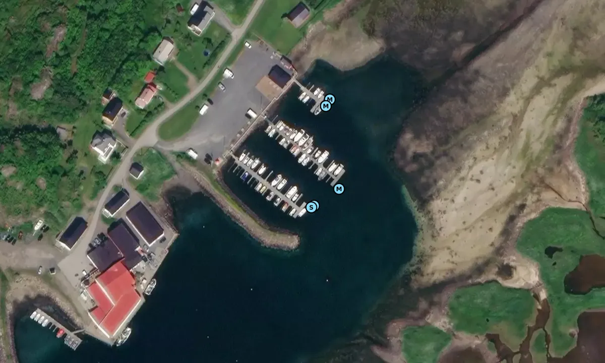
Satelite image of Vinjesjøen Båthavn

📸 Upload a photo

Show off your photos and help others plan their journey to Vinjesjøen Båthavn.harbourmaps.com is created by the sailing community, in a collective effort to make cruising simpler and more fun. Uploading a photo takes less than a minutes and can be done from your phone, tablet or laptop.

📸 Upload a photo

Facilities

Available facilities: Shore power, Fresh water, Shower, Toilet.

Updated on 17. Jul 2023. Update facilities.

Mooring

Options for mooring in this harbour: To pier/wharf.

Updated on 17. Jul 2023. Update mooring.

Contact information

website: Add website

phone: +4776135335

email: Add email

Descriptions and reviews

Ingeborg Lootz says:


area

maritime qualities

description

The middle pier has been upgraded this year. Space for two boats at the outermost part!

[translated from Norwegian with AI]

1 x helpful | written on 6. Aug 2025

Tommy Strøm says:

area

maritime qualities

description

Cozy small marina. We docked at the middle pier with a sailboat that drafts 2 meters (it was 4 meters deep at this pier). We called the watch phone (90888578) and got good assistance. The guest pier is the innermost one, but it looked a bit shallow there, so we chose the middle one. Call the watch phone before you arrive, and you'll get good help. There are toilets and showers that looked new, great service building.

[translated from Norwegian with AI]

1 x helpful | written on 16. Jul 2023 | updated_on 16. Jul 2023

Do you know this harbour? It's a huge help to other sailors if you add a short description or review of the harbour.

📜 Add description

Map of Vinjesjøen Båthavn

Facilities

Available facilities: Shore power, Fresh water, Shower, Toilet.

Updated on 17. Jul 2023. Update facilities.

Mooring

Options for mooring in this harbour: To pier/wharf.

Updated on 17. Jul 2023. Update mooring.

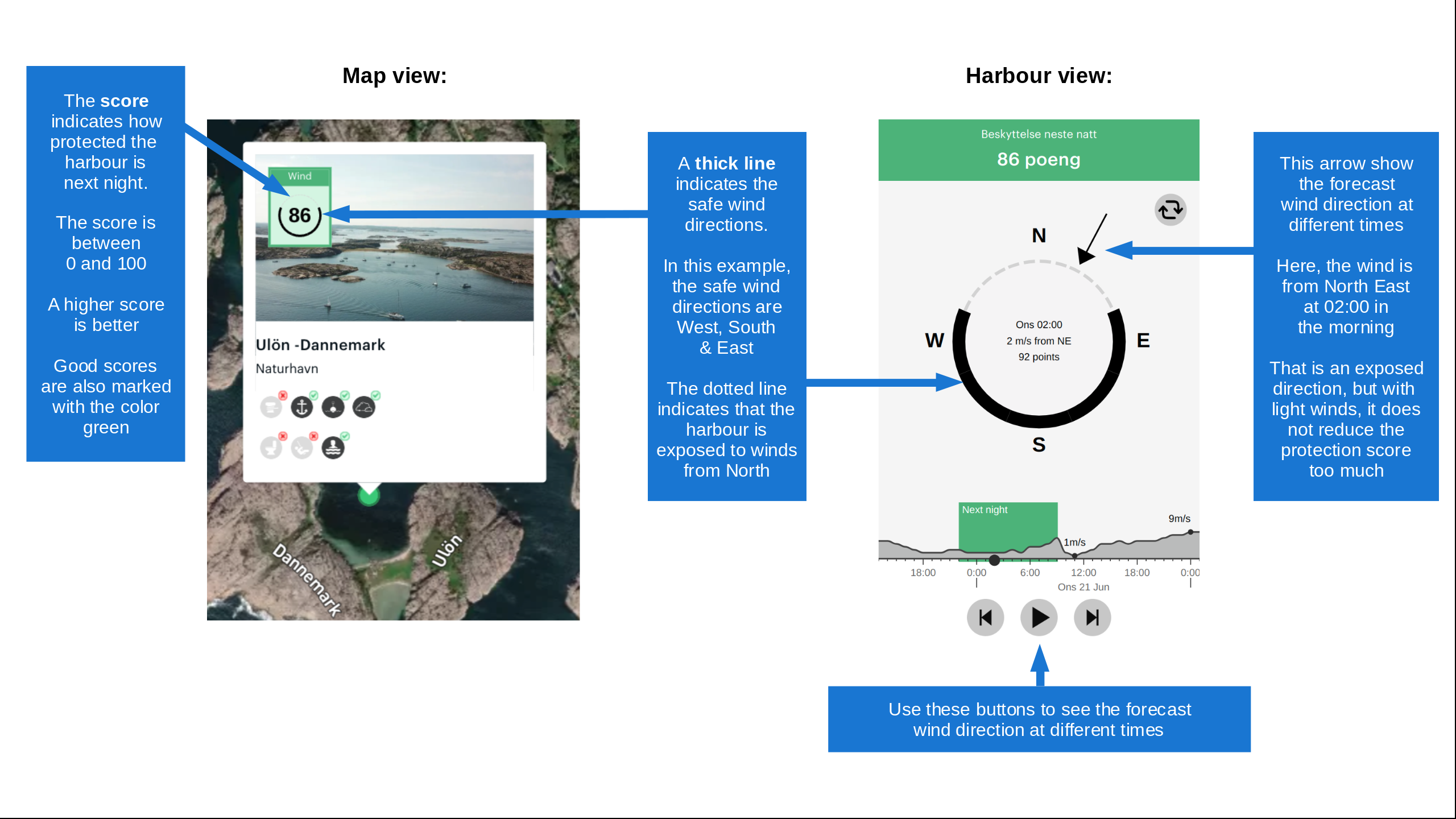
Wind protection

Protection next night

85 points

N E S W --> } } } } } } } } } } } } } } } } } } } } } } } } } } } } } } } } } } } } } } } } } } } } } } } } } } } } } } } } } } } } } } } } } } } } } } } } } } } } } } } } } } } } } } } } } } } } } } } } } } } } } } } } } } } } } } } } } } } } } } } } } } } } } } } } } } } } } } } } } } } } } } } } } } } } } } } } } } } } } } } } } } } } } } } } } } } } } } } } } } } } } } } } } } } } } } } } } } } } } } } } } } } } } } } } } } } } } } } } } } } } } } } } } } } } } } } } } } } } } } } } } } } } } } } } } } } } } } } } } } } } } } } } } } } } } } } } } } } } } } } } } } } } } } } } } } } } } } } } } } } } } } } } } } } } } } } } } } } } } } } } } } } } } } } } } } } } } } } } } } } } } } } } } } } } } } } } } } } } } } } } } } } } } } } } } } } } } } } } } } } } } } } } } } } } } } } } } } } } } } } } } } } } } } } } } } } } } } } } } } } } } } } } } } } } } } } } } } } } } } } } } } } } } } } } } } } } } } } } } } } } } } } } } } } } } } } } } } } } } } } } } } } } } } } } } } } } } } } } } } } } } } } } } } } } } } } } } } } } } } } } } } } } } } } } } } } } } } } } } } } } } } } } } } } } } } } } } } } } } } } } } } } } } } } } } } } } } } } } } } } } } } } } } } } } } } } } } } } } } } } } } } } } } } } } } } } } } } } } } } } } } } } } } } } } } } } } } } } } } } } } } } } } } } } } } } } } } } } } } } } } } } } } } } } } } } } } } } } } } } } } } } } } } } } } } } } } } } } } } } } } } } } } } } } } } } } } } } } } } } } } } } } } } } } } } } } } } } } } } } } } } } } } } } } } } } } } } } } } } } } } } } } } } } } } } } } } } } } } } } } } } } } } } } } } } } } } } } } } } } } } } } } } } } } } } } } } } } } } } } } } } } } } } } } } } } } } } } } } } } } } } } } } } } } } } } } } } } } } } } } } } } } } } } } } } } } } } } } } } } } } } } } } } } } } } } } } } } } } } } } } } } } } } } } } } } } } } } } } } } } } } } } } } } } } } } } } } } } } } } } } } } } } } } } } } } } } } } } } } } } } } } } } } } } } } } } } } } } } } } } } Next night 12:00 Fre 17 Jul 18:00 0:00 6:00 12:00 Lør 18 Jul 18:00 9m/s 5m/s

Want to know how the wind score works? Then you should read this explanation.

The wind forecasts come from yr.no (Norwegian Meteorological Institute), and was last updated 2 hours and 11 minutes ago (Friday 17 July 07:28 AM). The next night score shows you the worst hour between 22:00 and 08:00 the next night. We recommend that you check multiple sources for wind forecasts. windy.com is a good website to show larger wind systems.

The safe directions for this harbour was added at None. Click here to edit.

Last visits to Vinjesjøen Båthavn

Mon 07 Aug 2023

STELLA [MMSI: 257007650]

Thu 27 Jul 2023

IKKE BERIT [MMSI: 257043820]

MAAKEN EMMA [MMSI: 258004480]

YOLO [MMSI: 258998190]

TORA [MMSI: 257043690]

The visits are retrieved from AIS data. You can click to see all visiting ships to Vinjesjøen Båthavn, as well as statistics about the ships that visits

Add this harbour to a journey

Check in now

Choose a different date than today

Important: When you check in to a harbour, you add it to a journey on this website. You are not booking a place in the marina.

Contributors

Users that contributed to this page: John Lancaster-Smith and Tommy Strøm

harbourmaps.com is updated by the boating community. When you add information, a review or pictures to this page you are listed here with the other contributors (we list your user-name, which can be your real name or a pseudonym).

Closest harbours to Vinjesjøen Båthavn

Filter by

Natural harbour
Marina
Safe wind next night

Order by

ABC
Popularity
Wind score next night

0 harbours

Show more harbours