Ågerøya - Knutshavn

Puerto natural

favoritt

Region: Norway (3412), Agder (279), Aust-Agder (149), Lillesand (46), Blindleia (29) and Brekkestø (14)

Ågerøya - Knutshavn
Ågerøya - Knutshavn: {"base": "no", "no": "Bilde tatt mot s\u00f8r innerst i havna", "se": "Bild tagen mot s\u00f6der l\u00e4ngst in i hamnen", "en": "Picture taken towards the south, innermost in the harbor", "da": "Billede taget mod syd inderst i havnen", "fr": "Photo prise vers le sud \u00e0 l'int\u00e9rieur du port", "de": "Das Bild wurde in Richtung S\u00fcden am innersten Teil des Hafens aufgenommen", "es": "Imagen tomada hacia el sur en el interior del puerto", "it": "Immagine presa verso sud nella parte pi\u00f9 interna del porto", "pt": "Imagem tirada em dire\u00e7\u00e3o ao sul no fundo do porto", "nl": "Foto genomen naar het zuiden aan het einde van de haven", "pl": "Zdj\u0119cie zrobione na po\u0142udnie w g\u0142\u0119bi portu", "uk": "\u0417\u043e\u0431\u0440\u0430\u0436\u0435\u043d\u043d\u044f, \u0437\u0440\u043e\u0431\u043b\u0435\u043d\u0435 \u043d\u0430 \u043f\u0456\u0432\u0434\u0435\u043d\u044c, \u0443 \u043d\u0430\u0439\u0433\u043b\u0438\u0431\u0448\u0456\u0439 \u0447\u0430\u0441\u0442\u0438\u043d\u0456 \u0433\u0430\u0432\u0430\u043d\u0456", "ro": "Imagine f\u0103cut\u0103 spre sud, \u00een interiorul portului", "tr": "G\u00fcney y\u00f6n\u00fcnde \u00e7ekilmi\u015f resim, liman\u0131n en i\u00e7 k\u0131sm\u0131nda", "el": "\u0397 \u03b5\u03b9\u03ba\u03cc\u03bd\u03b1 \u03c4\u03c1\u03b1\u03b2\u03ae\u03c7\u03c4\u03b7\u03ba\u03b5 \u03c0\u03c1\u03bf\u03c2 \u03c4\u03b1 \u03bd\u03cc\u03c4\u03b9\u03b1 \u03c3\u03c4\u03bf \u03b5\u03c3\u03c9\u03c4\u03b5\u03c1\u03b9\u03ba\u03cc \u03c4\u03bf\u03c5 \u03bb\u03b9\u03bc\u03b1\u03bd\u03b9\u03bf\u03cd", "cs": "Fotografie po\u0159\u00edzen\u00e1 sm\u011brem na jih v nejvnit\u0159n\u011bj\u0161\u00ed \u010d\u00e1sti p\u0159\u00edstavu", "hu": "A k\u00e9p d\u00e9l fel\u00e9 n\u00e9z a kik\u00f6t\u0151 legbels\u0151 r\u00e9sz\u00e9n", "fi": "Kuva otettu etel\u00e4\u00e4n kohti sataman sis\u00e4osaa", "bg": "\u0421\u043d\u0438\u043c\u043a\u0430, \u043d\u0430\u043f\u0440\u0430\u0432\u0435\u043d\u0430 \u043d\u0430 \u044e\u0433 \u0432 \u0434\u044a\u043b\u0431\u043e\u043a\u0430\u0442\u0430 \u0447\u0430\u0441\u0442 \u043d\u0430 \u043f\u0440\u0438\u0441\u0442\u0430\u043d\u0438\u0449\u0435\u0442\u043e", "sr": "Slika snimljena prema jugu, duboko u luci", "et": "Pilt tehtud l\u00f5una suunas sadama sisemises osas", "lv": "Att\u0113ls uz dienvidiem no piest\u0101tnes iek\u0161puses", "lt": "Vaizdas piet\u0173 kryptimi i\u0161 uosto vidaus"}
Ågerøya - Knutshavn: {"base": "no", "no": "Det er en grunne i innseilingen som er merket med en liten r\u00f8d stake", "se": "Det finns ett grund i inseglingsr\u00e4nnan som \u00e4r markerat med en liten r\u00f6d stake.", "en": "There is a shoal in the approach which is marked with a small red beacon", "da": "Der er et grundt omr\u00e5de i indsejlingen, som er m\u00e6rket med en lille r\u00f8d stage", "fr": "Il y a un haut-fond dans le chenal d'entr\u00e9e qui est marqu\u00e9 par une petite balise rouge", "de": "Es gibt eine Untiefe in der Zufahrt, die mit einer kleinen roten Bake markiert ist.", "es": "Hay un banco en la entrada marcado con una peque\u00f1a estaca roja", "it": "C'\u00e8 un fondale basso all'ingresso che \u00e8 segnalato con un piccolo palo rosso", "pt": "H\u00e1 um banco de areia na entrada que est\u00e1 sinalizado com uma pequena estaca vermelha", "nl": "Er is een ondiepte in de aanloop die is gemarkeerd met een kleine rode paal.", "pl": "Na wej\u015bciu do portu znajduje si\u0119 mielizna oznaczona ma\u0142\u0105 czerwon\u0105 tyczk\u0105.", "uk": "\u0490\u0440\u0443\u043d\u0442\u043e\u0432\u043d\u0430 \u043c\u0456\u043b\u0438\u043d\u0430 \u043d\u0430 \u043f\u0456\u0434\u0445\u043e\u0434\u0456 \u043f\u043e\u0437\u043d\u0430\u0447\u0435\u043d\u0430 \u043c\u0430\u043b\u043e\u044e \u0447\u0435\u0440\u0432\u043e\u043d\u043e\u044e \u043f\u0430\u043b\u0438\u0446\u0435\u044e", "ro": "Exist\u0103 un banc de nisip la intrare, marcat cu un \u021b\u0103ru\u0219 ro\u0219u mic", "tr": "Giri\u015fte k\u00fc\u00e7\u00fck k\u0131rm\u0131z\u0131 bir kaz\u0131kla i\u015faretlenmi\u015f bir s\u0131\u011fl\u0131k var.", "el": "\u03a5\u03c0\u03ac\u03c1\u03c7\u03b5\u03b9 \u03ad\u03bd\u03b1 \u03b1\u03b2\u03b1\u03b8\u03ad\u03c2 \u03c3\u03c4\u03b7\u03bd \u03b5\u03af\u03c3\u03bf\u03b4\u03bf \u03c0\u03bf\u03c5 \u03b5\u03af\u03bd\u03b1\u03b9 \u03c3\u03b7\u03bc\u03b5\u03b9\u03c9\u03bc\u03ad\u03bd\u03bf \u03bc\u03b5 \u03ad\u03bd\u03b1\u03bd \u03bc\u03b9\u03ba\u03c1\u03cc \u03ba\u03cc\u03ba\u03ba\u03b9\u03bd\u03bf \u03c0\u03ac\u03c3\u03c3\u03b1\u03bb\u03bf", "cs": "V p\u0159\u00edstavu je m\u011bl\u010dina, kter\u00e1 je ozna\u010dena mal\u00fdm \u010derven\u00fdm kol\u00edkem", "hu": "Az bej\u00e1ratn\u00e1l van egy z\u00e1tony, amelyet egy kis piros kar\u00f3val jel\u00f6ltek", "fi": "Sis\u00e4\u00e4ntulossa on karikko, joka on merkitty pienell\u00e4 punaisella merkkikepill\u00e4", "bg": "\u0418\u043c\u0430 \u043f\u043b\u0438\u0442\u0447\u0438\u043d\u0430 \u0432 \u043d\u0430\u0432\u0438\u0433\u0430\u0446\u0438\u044f\u0442\u0430 \u043a\u044a\u043c \u043f\u0440\u0438\u0441\u0442\u0430\u043d\u0438\u0449\u0435\u0442\u043e, \u043a\u043e\u044f\u0442\u043e \u0435 \u043e\u0442\u0431\u0435\u043b\u044f\u0437\u0430\u043d\u0430 \u0441 \u043c\u0430\u043b\u044a\u043a \u0447\u0435\u0440\u0432\u0435\u043d \u0437\u043d\u0430\u043a.", "sr": "\u041f\u043e\u0441\u0442\u043e\u0458\u0438 \u043f\u043b\u0438\u045b\u0430\u043a \u043f\u0440\u0438 \u0443\u043b\u0430\u0437\u0443 \u043a\u043e\u0458\u0438 \u0458\u0435 \u043e\u0431\u0435\u043b\u0435\u0436\u0435\u043d \u043c\u0430\u043b\u0438\u043c \u0446\u0440\u0432\u0435\u043d\u0438\u043c \u0441\u0442\u0443\u0431\u043e\u043c", "et": "Sisses\u00f5idul on madalik, mis on t\u00e4histatud v\u00e4ikese punase postiga", "lv": "Ir sekls \u016bdens ieej\u0101, kas ir iez\u012bm\u0113ts ar nelielu sarkano stabuli", "lt": "\u012eplaukos kelyje yra sekli vieta, pa\u017eym\u0117ta ma\u017eu raudonu stulpeliu."}
Ågerøya - Knutshavn: {"base": "no", "no": "Helt s\u00f8r p\u00e5 \u00f8ya", "se": "Helt s\u00f6der p\u00e5 \u00f6n", "en": "All the way south on the island", "da": "Helt syd p\u00e5 \u00f8en", "fr": "Tout au sud de l'\u00eele", "de": "Ganz im S\u00fcden der Insel", "es": "El extremo sur de la isla", "it": "All'estremit\u00e0 meridionale dell'isola", "pt": "Extremo sul da ilha", "nl": "Helemaal in het zuiden van het eiland", "pl": "Ca\u0142kowicie na po\u0142udniu wyspy", "uk": "\u041d\u0430 \u0441\u0430\u043c\u043e\u043c\u0443 \u043f\u0456\u0432\u0434\u043d\u0456 \u043e\u0441\u0442\u0440\u043e\u0432\u0430", "ro": "\u00cen sudul extrem al insulei", "tr": "Adan\u0131n tam g\u00fcneyinde", "el": "\u0395\u03bd\u03c4\u03b5\u03bb\u03ce\u03c2 \u03bd\u03cc\u03c4\u03b9\u03b1 \u03c3\u03c4\u03bf \u03bd\u03b7\u03c3\u03af", "cs": "\u00dapln\u011b na jihu ostrova", "hu": "Eg\u00e9szen d\u00e9len a szigeten", "fi": "Aivan saaren etel\u00e4puolella", "bg": "\u041d\u0430\u0439-\u044e\u0436\u043d\u0430\u0442\u0430 \u0447\u0430\u0441\u0442 \u043d\u0430 \u043e\u0441\u0442\u0440\u043e\u0432\u0430", "sr": "Potpuno na jugu ostrva", "et": "Kaugemas l\u00f5unas saarel", "lv": "Pavisam dienvidos uz salas", "lt": "Pa\u010dioje pietin\u0117je salos dalyje"}
Ågerøya - Knutshavn
Ågerøya - Knutshavn: {"base": "no", "no": "Den nordre innseilingen", "se": "Den norra infarten", "en": "The northern approach", "da": "Den nordlige indsejling", "fr": "L'entr\u00e9e nord", "de": "Der n\u00f6rdliche Einlauf", "es": "La entrada norte", "it": "L'ingresso settentrionale", "pt": "A entrada norte", "nl": "De noordelijke binnenvaart", "pl": "P\u00f3\u0142nocne podej\u015bcie", "uk": "\u041f\u0456\u0432\u043d\u0456\u0447\u043d\u0438\u0439 \u0432\u0445\u0456\u0434", "ro": "Canalul de nord", "tr": "Kuzey giri\u015f yolu", "el": "\u0397 \u03b2\u03cc\u03c1\u03b5\u03b9\u03b1 \u03b5\u03af\u03c3\u03bf\u03b4\u03bf\u03c2", "cs": "Severn\u00ed p\u0159\u00edstup", "hu": "Az \u00e9szaki bej\u00e1rat", "fi": "Pohjois-sis\u00e4\u00e4najo", "bg": "\u0421\u0435\u0432\u0435\u0440\u043d\u0438\u044f\u0442 \u043f\u043e\u0434\u0445\u043e\u0434", "sr": "Severni ulaz", "et": "P\u00f5hjapoolne sissep\u00e4\u00e4s", "lv": "Zieme\u013cu iebrauktuve", "lt": "\u0160iaurinis \u012fplaukimas"}
Ågerøya - Knutshavn
Ågerøya - Knutshavn: {"base": "no", "no": "Innseilinga fra nord.", "se": "Inseglingen fr\u00e5n norr.", "en": "The approach from the north.", "da": "Indsejlingen fra nord."}
Ågerøya - Knutshavn
Ågerøya - Knutshavn
Satelite image of Ågerøya - Knutshavn

📸 Sube una foto

Muestra tus fotos y ayuda a otros a planificar su viaje a Ågerøya - Knutshavn.harbourmaps.com es creado por la comunidad de navegación, en un esfuerzo colectivo para hacer la navegación más simple y divertida. Subir una foto toma menos de un minuto y se puede hacer desde tu teléfono, tableta o portátil.

📸 Sube una foto

Instalaciones

Instalaciones disponibles: Aseo, Parque infantil.

Actualizado el 14. Jul 2023. Actualizar instalaciones.

Amarre

Opciones para amarre en este puerto: Hacia tierra.

Actualizado el 14. Jul 2023. Actualizar amarre.

Descripciones y reseñas

Lars Hatletveit dice:

área

cualidades marítimas

descripción

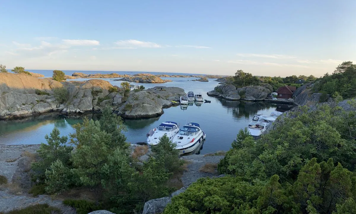
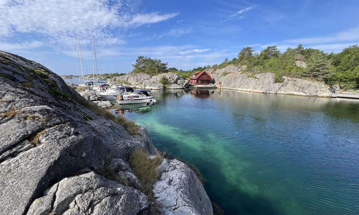
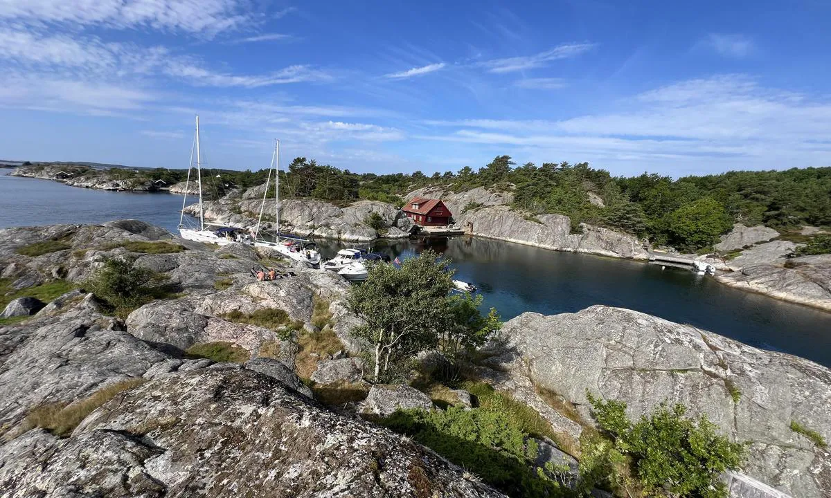
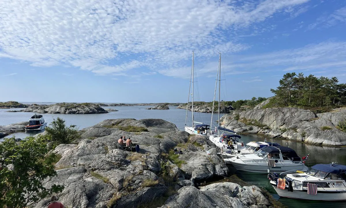
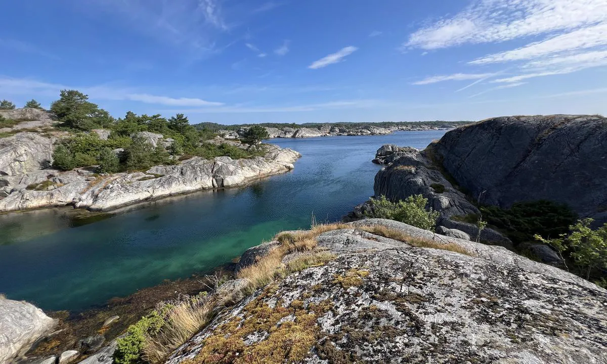
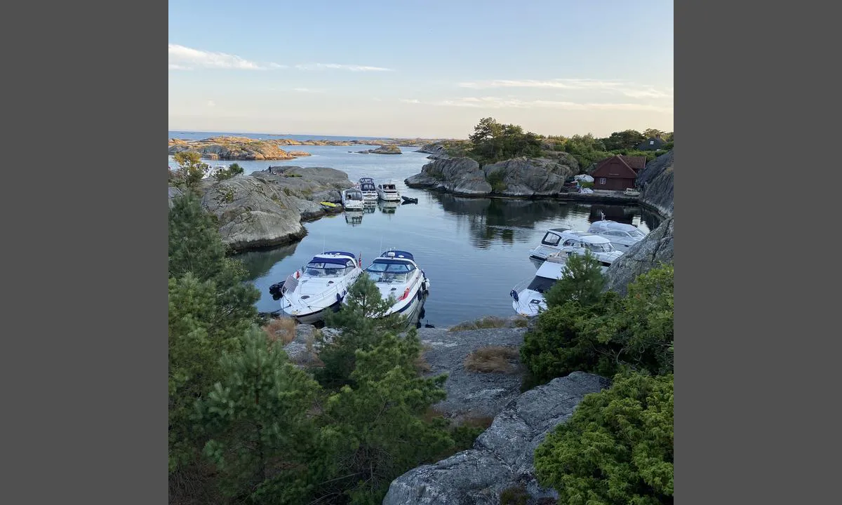
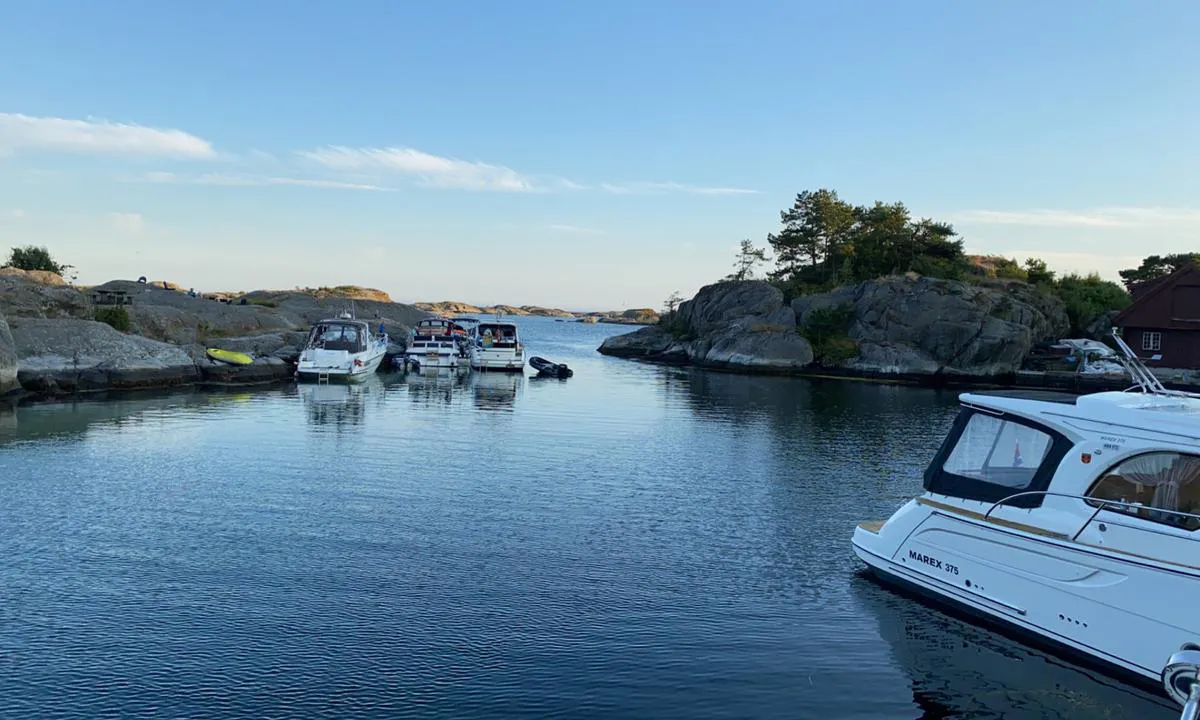
Hay algunos bajos en la zona, así que estudia el mapa antes de entrar, especialmente desde el sur, pero no es difícil.
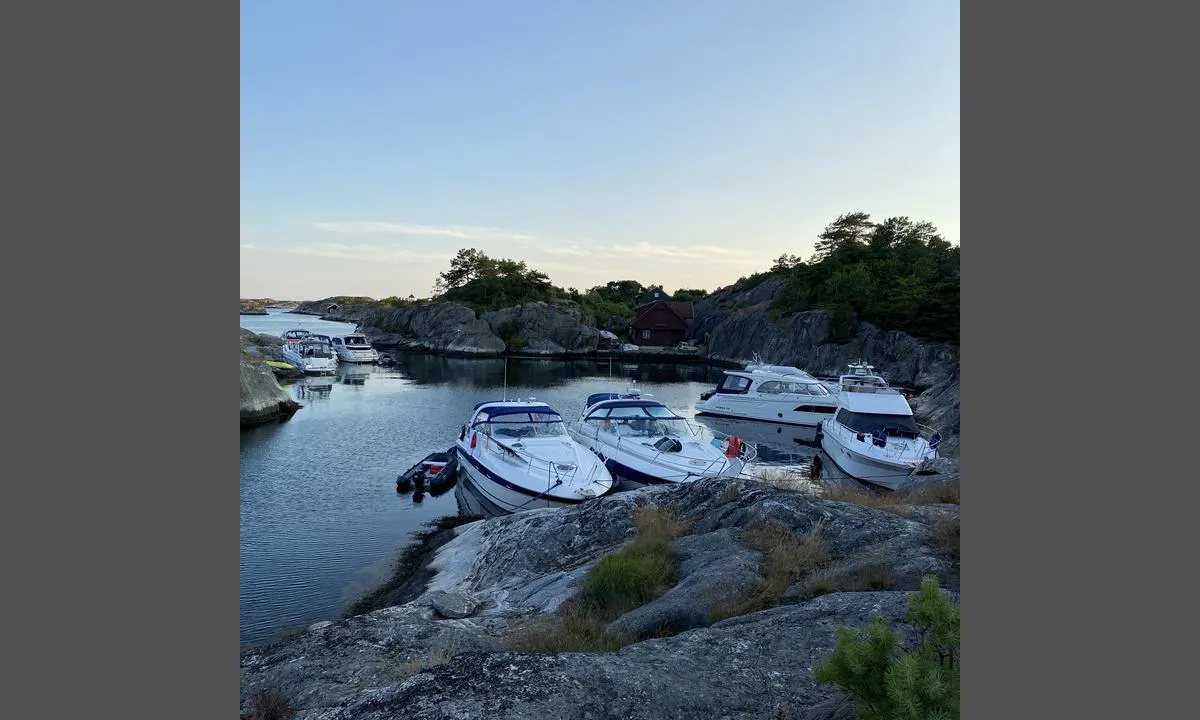
Hay un poco de tráfico en el estrecho de pequeñas embarcaciones, pero está tranquilo por la mañana y por la tarde.
La parte sur del puerto está un poco expuesta a vientos del este, donde estábamos nosotros. Según Yr, había alrededor de 5 m/s con ráfagas de hasta 8. Esto generó un poco de oleaje en el puerto. El mar se refleja en la montaña. Tal vez no me quedaría aquí con vientos más fuertes del este. En el norte del puerto es mejor entonces.

[translated from Norwegian with AI]

1 x helpful | written on 1. Aug 2025

¿Conoces este puerto? Es de gran ayuda para otros marineros si añades una breve descripción o reseña del puerto.

📜 Añadir descripción

Mapa de Ågerøya - Knutshavn

Instalaciones

Instalaciones disponibles: Aseo, Parque infantil.

Actualizado el 14. Jul 2023. Actualizar instalaciones.

Amarre

Opciones para amarre en este puerto: Hacia tierra.

Actualizado el 14. Jul 2023. Actualizar amarre.

Protección contra el viento

Protección próxima noche

92 puntos

N E S W --> } } } } } } } } } } } } } } } } } } } } } } } } } } } } } } } } } } } } } } } } } } } } } } } } } } } } } } } } } } } } } } } } } } } } } } } } } } } } } } } } } } } } } } } } } } } } } } } } } } } } } } } } } } } } } } } } } } } } } } } } } } } } } } } } } } } } } } } } } } } } } } } } } } } } } } } } } } } } } } } } } } } } } } } } } } } } } } } } } } } } } } } } } } } } } } } } } } } } } } } } } } } } } } } } } } } } } } } } } } } } } } } } } } } } } } } } } } } } } } } } } } } } } } } } } } } } } } } } } } } } } } } } } } } } } } } } } } } } } } } } } } } } } } } } } } } } } } } } } } } } } } } } } } } } } } } } } } } } } } } } } } } } } } } } } } } } } } } } } } } } } } } } } } } } } } } } } } } } } } } } } } } } } } } } } } } } } } } } } } } } } } } } } } } } } } } } } } } } } } } } } } } } } } } } } } } } } } } } } } } } } } } } } } } } } } } } } } } } } } } } } } } } } } } } } } } } } } } } } } } } } } } } } } } } } } } } } } } } } } } } } } } } } } } } } } } } } } } } } } } } } } } } } } } } } } } } } } } } } } } } } } } } } } } } } } } } } } } } } } } } } } } } } } } } } } } } } } } } } } } } } } } } } } } } } } } } } } } } } } } } } } } } } } } } } } } } } } } } } } } } } } } } } } } } } } } } } } } } } } } } } } } } } } } } } } } } } } } } } } } } } } } } } } } } } } } } } } } } } } } } } } } } } } } } } } } } } } } } } } } } } } } } } } } } } } } } } } } } } } } } } } } } } } } } } } } } } } } } } } } } } } } } } } } } } } } } } } } } } } } } } } } } } } } } } } } } } } } } } } } } } } } } } } } } } } } } } } } } } } } } } } } } } } } } } } } } } } } } } } } } } } } } } } } } } } } } } } } } } } } } } } } } } } } } } } } } } } } } } } } } } } } } } } } } } } } } } } } } } } } } } } } } } } } } } } } } } } } } } } } } } } } } } } } } } } } } } } } } } } } } } } } } } } } } } } } } } } } } } } } } } } } } } } } } } } } } } } } } } } } } } } } } } } } } } } } } } } } } } } } } } } } } } } } } } } } } } } } } } } } } Next night 0:00 6:00 12:00 Man 11 Aug 18:00 0:00 6:00 7m/s 2m/s

¿Quieres saber cómo funciona la puntuación del viento? Entonces deberías leer esta explicación.

Las previsiones del viento provienen de yr.no (Instituto Meteorológico Noruego), y se actualizaron por última vez 1 hour and 11 minutes ago (Domingo 10 Agosto 21:28). La siguiente puntuación nocturna te muestra la peor hora entre las 22:00 y las 08:00 de la siguiente noche. Recomendamos que consultes varias fuentes para los pronósticos de viento.windy.com es un buen sitio web para mostrar sistemas eólicos más grandes.

Las direcciones seguras para este puerto se añadieron en 21. Jul 2021. Haga clic aquí para editar.

Últimas visitas a Ågerøya - Knutshavn

Mié 23 Ago 2023

LAZYDAYS [MMSI: 258007880]

Jue 20 Jul 2023

LILLE MY [MMSI: 258015680]

Mar 18 Jul 2023

S/Y HUGIN [MMSI: 219017172]

Lun 17 Jul 2023

AYUTTHAYA II [MMSI: 257810160]

The visits are retrieved from AIS data. You can click to see all visiting ships to Ågerøya - Knutshavn, as well as statistics about the ships that visits

Añadir este puerto a un viaje

Regístrate ahora

Elija una fecha diferente a la de hoy

Importante: Cuando inicias sesión en un puerto, lo agregas a un viaje en este sitio web. No estás reservando un lugar en la marina.

Colaboradores

Usuarios que contribuyeron a esta página: Olav Pekeberg, Tove Lunde, Lars Hatletveit and Stig Robert Gjertsen

harbourmaps.com es actualizado por la comunidad de navegantes. Cuando agregas información, una revisión o fotos a esta página, te enumeramos aquí con los otros contribuyentes (listamos tu nombre de usuario, que puede ser tu nombre real o un seudónimo).

Puertos más cercanos a Ågerøya - Knutshavn

Filtrar por

Puerto natural
Marina
Viento seguro la próxima noche

Ordenar por

ABC
Popularidad
Puntuación de viento próxima noche

0 puertos

Mostrar más puertos