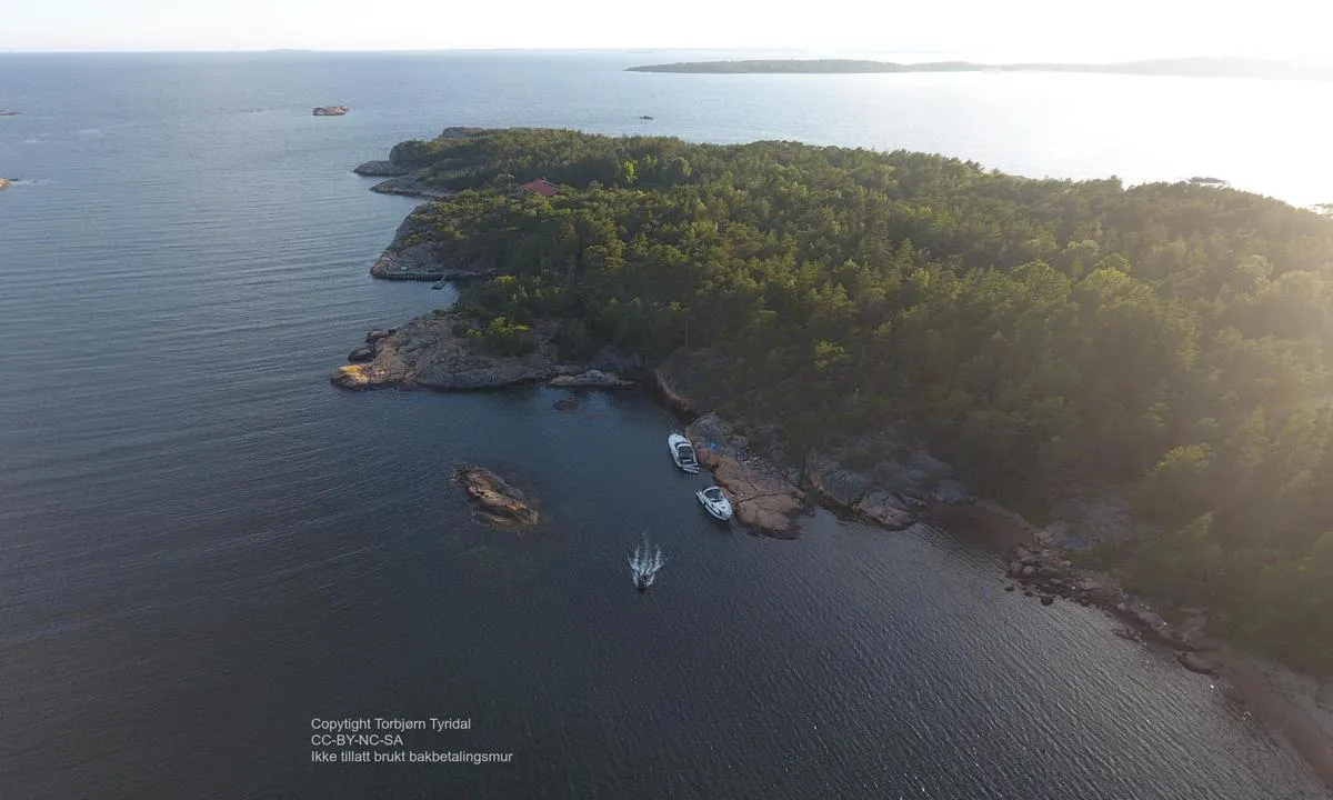
Risholmen - øst: {"base": "no", "no": "Longside langs fjellet. Innseiling fra nord. Se opp for grunne mellom \u00f8ya og den lille holmen i \u00f8st.", "se": "L\u00e5ngsides l\u00e4ngs berget. Insegling fr\u00e5n norr. Se upp f\u00f6r grundet mellan \u00f6n och den lilla holmen i \u00f6ster.", "en": "Alongside the mountain. Approach from the north. Watch out for the shallow area between the island and the small islet to the east.", "da": "Langside langs bjerget. Indsejling fra nord. Hold \u00f8je med grunden mellem \u00f8en og den lille holm i \u00f8st.", "fr": "Longside le long de la montagne. Entr\u00e9e par le nord. Attention au haut-fond entre l'\u00eele et le petit \u00eelot \u00e0 l'est.", "de": "L\u00e4ngsseite entlang des Felsens. Einfahrt von Norden. Achten Sie auf die Untiefe zwischen der Insel und dem kleinen Eiland im Osten.", "es": "A lo largo del lado largo del acantilado. Entrada desde el norte. Tenga cuidado con el baj\u00edo entre la isla y el peque\u00f1o islote al este.", "it": "Al fianco della montagna. Ingresso dal nord. Attenzione ai bassi fondali tra l'isola e il piccolo isolotto a est.", "pt": "Longside ao longo da montanha. Entrada pelo norte. Cuidado com a \u00e1rea rasa entre a ilha e o pequeno ilh\u00e9u a leste.", "nl": "Langszij langs de rotsen. Binnenvaren vanuit het noorden. Pas op voor ondieptes tussen het eiland en het kleine eilandje in het oosten.", "pl": "Longside wzd\u0142u\u017c ska\u0142y. Wej\u015bcie od p\u00f3\u0142nocy. Uwa\u017caj na p\u0142ytkie wody mi\u0119dzy wysp\u0105 a ma\u0142ym szkierem na wschodzie.", "uk": "\u041f\u043e\u0434\u043e\u0432\u0436\u043d\u044c\u043e \u0443\u0437\u0434\u043e\u0432\u0436 \u0441\u043a\u0435\u043b\u0456. \u0412'\u0457\u0437\u0434 \u0437 \u043f\u0456\u0432\u043d\u043e\u0447\u0456. \u0421\u0442\u0435\u0440\u0435\u0436\u0456\u0442\u044c\u0441\u044f \u043c\u0456\u043b\u0438\u043d\u0438 \u043c\u0456\u0436 \u043e\u0441\u0442\u0440\u043e\u0432\u043e\u043c \u0456 \u043c\u0430\u043b\u0435\u043d\u044c\u043a\u0438\u043c \u043e\u0441\u0442\u0440\u0456\u0432\u0446\u0435\u043c \u043d\u0430 \u0441\u0445\u043e\u0434\u0456.", "ro": "Pe lateral, de-a lungul mun\u021bilor. Intrarare dinspre nord. Aten\u021bie la ad\u00e2ncimea mic\u0103 \u00eentre insul\u0103 \u0219i mica st\u00e2nc\u0103 din est.", "tr": "Fiyata paralel yana\u015fma. Kuzeyden giri\u015f. Do\u011fudaki k\u00fc\u00e7\u00fck adac\u0131k ile ada aras\u0131ndaki s\u0131\u011fl\u0131\u011fa dikkat edin.", "el": "\u03a0\u03bb\u03b1\u03b3\u03af\u03c9\u03c2 \u03ba\u03b1\u03c4\u03ac \u03bc\u03ae\u03ba\u03bf\u03c2 \u03c4\u03bf\u03c5 \u03b2\u03bf\u03c5\u03bd\u03bf\u03cd. \u03a0\u03c1\u03cc\u03c3\u03b2\u03b1\u03c3\u03b7 \u03b1\u03c0\u03cc \u03c4\u03bf\u03bd \u03b2\u03bf\u03c1\u03c1\u03ac. \u03a0\u03c1\u03bf\u03c3\u03bf\u03c7\u03ae \u03c3\u03c4\u03b1 \u03c1\u03b7\u03c7\u03ac \u03bd\u03b5\u03c1\u03ac \u03bc\u03b5\u03c4\u03b1\u03be\u03cd \u03c4\u03bf\u03c5 \u03bd\u03b7\u03c3\u03b9\u03bf\u03cd \u03ba\u03b1\u03b9 \u03c4\u03b7\u03c2 \u03bc\u03b9\u03ba\u03c1\u03ae\u03c2 \u03bd\u03b7\u03c3\u03af\u03b4\u03b1\u03c2 \u03c3\u03c4\u03b1 \u03b1\u03bd\u03b1\u03c4\u03bf\u03bb\u03b9\u03ba\u03ac.", "cs": "Sou\u010d\u00e1st\u00ed pod\u00e9l sk\u00e1ly. Vjezd od severu. Pozor na m\u011bl\u010dinu mezi ostrovem a mal\u00fdm ostr\u016fvkem na v\u00fdchod\u011b.", "hu": "Hossz\u00e1ban a hegy mellett. Behaj\u00f3z\u00e1s \u00e9szak fel\u0151l. Vigy\u00e1zzon a z\u00e1tonyra a sziget \u00e9s a keleti kis sziklaszirt k\u00f6z\u00f6tt.", "fi": "Longside vuoren vieress\u00e4. Sis\u00e4\u00e4najo pohjoisesta. Varo matalikkoa saaren ja pienen luodon v\u00e4lill\u00e4 id\u00e4ss\u00e4.", "bg": "\u0414\u044a\u043b\u0433\u0438\u044f\u0442 \u043a\u0435\u0439 \u043f\u043e\u043a\u0440\u0430\u0439 \u0441\u043a\u0430\u043b\u0430\u0442\u0430. \u0412\u0445\u043e\u0434 \u043e\u0442 \u0441\u0435\u0432\u0435\u0440. \u0412\u043d\u0438\u043c\u0430\u0432\u0430\u0439\u0442\u0435 \u0437\u0430 \u043f\u043b\u0438\u0442\u0447\u0438\u043d\u0430\u0442\u0430 \u043c\u0435\u0436\u0434\u0443 \u043e\u0441\u0442\u0440\u043e\u0432\u0430 \u0438 \u043c\u0430\u043b\u043a\u043e\u0442\u043e \u043e\u0441\u0442\u0440\u043e\u0432\u0447\u0435 \u043d\u0430 \u0438\u0437\u0442\u043e\u043a.", "sr": "\u0414\u0443\u0436 \u0431\u043e\u043a\u0430 \u043f\u043e\u0440\u0435\u0434 \u0441\u0442\u0435\u043d\u0435. \u0423\u043b\u0430\u0437 \u0441\u0430 \u0441\u0435\u0432\u0435\u0440\u0430. \u041f\u0430\u0437\u0438\u0442\u0435 \u043d\u0430 \u043f\u043b\u0438\u0442\u043a\u043e \u0438\u0437\u043c\u0435\u0452\u0443 \u043e\u0441\u0442\u0440\u0432\u0430 \u0438 \u043c\u0430\u043b\u043e\u0433 \u0445\u0440\u0438\u0434\u0438 \u043d\u0430 \u0438\u0441\u0442\u043e\u043a\u0443.", "et": "Fjelli \u00e4\u00e4res k\u00f5rvuti. Sisses\u00f5it p\u00f5hjast. Hoidu madaliku eest saare ja idas asuva v\u00e4ikese saarekese vahel.", "lv": "Gar s\u0101niem gar kalnu. Iebrauk\u0161ana no zieme\u013ciem. Uzmanieties no sekluma starp salu un mazajiem klin\u0161ainajiem sali\u0146\u0101m austrumos.", "lt": "\u0160oninis priplaukimas palei uol\u0105. \u012eplaukimas i\u0161 \u0161iaur\u0117s. Saugokit\u0117s seklumos tarp salos ir ma\u017eojo i\u0161ky\u0161ulio rytuose."}
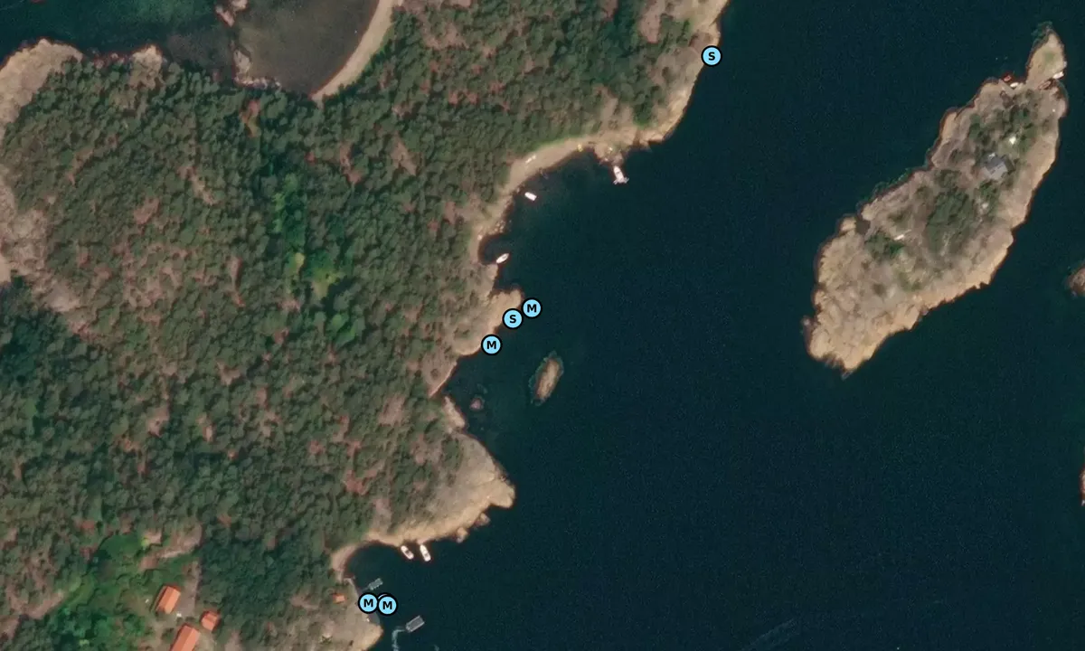
Satelite image of Risholmen - øst

📸 Upload a photo

Show off your photos and help others plan their journey to Risholmen - øst.harbourmaps.com is created by the sailing community, in a collective effort to make cruising simpler and more fun. Uploading a photo takes less than a minutes and can be done from your phone, tablet or laptop.

📸 Upload a photo

Facilities

Available facilities: Swimming area.

Updated on 26. Jul 2025. Update facilities.

Mooring

Options for mooring in this harbour: Towards land.

Updated on 26. Jul 2025. Update mooring.

Descriptions and reviews

Torbjorn says:

area

maritime qualities

description

Longside along the rock on Risholmen.
Easy approach from the north. Shallow at the innermost part, not possible to sail in from the south.


[translated from Norwegian with AI]

1 x helpful | written on 25. Jul 2025

Do you know this harbour? It's a huge help to other sailors if you add a short description or review of the harbour.

📜 Add description

Map of Risholmen - øst

Facilities

Available facilities: Swimming area.

Updated on 26. Jul 2025. Update facilities.

Mooring

Options for mooring in this harbour: Towards land.

Updated on 26. Jul 2025. Update mooring.

Wind protection

Protection next night

85 points

N E S W --> } } } } } } } } } } } } } } } } } } } } } } } } } } } } } } } } } } } } } } } } } } } } } } } } } } } } } } } } } } } } } } } } } } } } } } } } } } } } } } } } } } } } } } } } } } } } } } } } } } } } } } } } } } } } } } } } } } } } } } } } } } } } } } } } } } } } } } } } } } } } } } } } } } } } } } } } } } } } } } } } } } } } } } } } } } } } } } } } } } } } } } } } } } } } } } } } } } } } } } } } } } } } } } } } } } } } } } } } } } } } } } } } } } } } } } } } } } } } } } } } } } } } } } } } } } } } } } } } } } } } } } } } } } } } } } } } } } } } } } } } } } } } } } } } } } } } } } } } } } } } } } } } } } } } } } } } } } } } } } } } } } } } } } } } } } } } } } } } } } } } } } } } } } } } } } } } } } } } } } } } } } } } } } } } } } } } } } } } } } } } } } } } } } } } } } } } } } } } } } } } } } } } } } } } } } } } } } } } } } } } } } } } } } } } } } } } } } } } } } } } } } } } } } } } } } } } } } } } } } } } } } } } } } } } } } } } } } } } } } } } } } } } } } } } } } } } } } } } } } } } } } } } } } } } } } } } } } } } } } } } } } } } } } } } } } } } } } } } } } } } } } } } } } } } } } } } } } } } } } } } } } } } } } } } } } } } } } } } } } } } } } } } } } } } } } } } } } } } } } } } } } } } } } } } } } } } } } } } } } } } } } } } } } } } } } } } } } } } } } } } } } } } } } } } } } } } } } } } } } } } } } } } } } } } } } } } } } } } } } } } } } } } } } } } } } } } } } } } } } } } } } } } } } } } } } } } } } } } } } } } } } } } } } } } } } } } } } } } } } } } } } } } } } } } } } } } } } } } } } } } } } } } } } } } } } } } } } } } } } } } } } } } } } } } } } } } } } } } } } } } } } } } } } } } } } } } } } } } } } } } } } } } } } } } } } } } } } } } } } } } } } } } } } } } } } } } } } } } } } } } } } } } } } } } } } } } } } } } } } } } } } } } } } } } } } } } } } } } } } } } } } } } } } } } } } } } } } } } } } } } } } } } } } } } } } } } } } } } } } } } } } } } } } } } } } } } } } } } } } } } } } } } } } } } } } } } } } } } } } } } Next night 12:00 Søn 27 Jul 18:00 0:00 6:00 12:00 Man 28 Jul 18:00 5m/s 1m/s

Want to know how the wind score works? Then you should read this explanation.

The wind forecasts come from yr.no (Norwegian Meteorological Institute), and was last updated 1 hour and 34 minutes ago (Sunday 27 July 06:27 AM). The next night score shows you the worst hour between 22:00 and 08:00 the next night. We recommend that you check multiple sources for wind forecasts. windy.com is a good website to show larger wind systems.

The safe directions for this harbour was added at 26. Jul 2025. Click here to edit.

Last visits to Risholmen - øst

Fri 13 Jun 2025

SY WAAGEN [MMSI: 257582770]

Wed 28 May 2025

FAIR HAVEN [MMSI: 258212440]

Sat 10 May 2025

MAY HOLIDAY [MMSI: 257043060]

Fri 02 May 2025

FAIR HAVEN [MMSI: 258212440]

Fri 25 Apr 2025

NANCY-S [MMSI: 257599030]

The visits are retrieved from AIS data. You can click to see all visiting ships to Risholmen - øst, as well as statistics about the ships that visits

Add this harbour to a journey

Check in now

Choose a different date than today

Important: When you check in to a harbour, you add it to a journey on this website. You are not booking a place in the marina.

Contributors

Users that contributed to this page: Torbjorn

harbourmaps.com is updated by the boating community. When you add information, a review or pictures to this page you are listed here with the other contributors (we list your user-name, which can be your real name or a pseudonym).

Closest harbours to Risholmen - øst

Filter by

Natural harbour
Marina
Safe wind next night

Order by

ABC
Popularity
Wind score next night

0 harbours

Show more harbours