Seskarö Leppäniemikajen

Marina

favoritt

Region: Sweden (2089), Norrbotten (36), Haparanda (4) and Seskarö (3)

Seskarö Leppäniemikajen: {"base": "en", "no": "Innsiden av trepontongen", "se": "Insidan av tr\u00e4pontonen", "en": "The inside of the wooden pontoon", "da": "Indsiden af den tr\u00e6pontonen", "fr": "L'int\u00e9rieur du ponton en bois", "de": "Das Innere des Holzpontons", "es": "El interior del pantalan de madera", "it": "L'interno del pontile di legno", "pt": "O interior do pont\u00e3o de madeira", "nl": "De binnenkant van de houten ponton", "pl": "Wn\u0119trze drewnianego p\u0142ywaj\u0105cego pomostu", "uk": "\u0412\u043d\u0443\u0442\u0440\u0456\u0448\u043d\u044f \u0441\u0442\u043e\u0440\u043e\u043d\u0430 \u0434\u0435\u0440\u0435\u0432'\u044f\u043d\u043e\u0433\u043e \u043f\u043e\u043d\u0442\u043e\u043d\u0443", "ro": "Interiorul pontonului de lemn", "tr": "Ah\u015fap iskele pontonunun i\u00e7 k\u0131sm\u0131", "el": "\u03a4\u03bf \u03b5\u03c3\u03c9\u03c4\u03b5\u03c1\u03b9\u03ba\u03cc \u03c4\u03b7\u03c2 \u03be\u03cd\u03bb\u03b9\u03bd\u03b7\u03c2 \u03c0\u03bb\u03c9\u03c4\u03ae\u03c2 \u03b1\u03c0\u03bf\u03b2\u03ac\u03b8\u03c1\u03b1\u03c2", "cs": "Vnit\u0159n\u00ed strana d\u0159ev\u011bn\u00e9ho pontonu", "hu": "A f\u00e1b\u00f3l k\u00e9sz\u00fclt ponton belseje", "fi": "Puisen ponttoonin sis\u00e4puoli", "bg": "\u0412\u044a\u0442\u0440\u0435\u0448\u043d\u043e\u0441\u0442\u0442\u0430 \u043d\u0430 \u0434\u044a\u0440\u0432\u0435\u043d\u0438\u044f \u043f\u043e\u043d\u0442\u043e\u043d", "sr": "Unutra\u0161njost drvenog pontona", "et": "Puidust pontooni sisek\u00fclg", "lv": "Koka pontona iek\u0161puse", "lt": "Medinio pontono vidus"}
Seskarö Leppäniemikajen: {"base": "en", "no": "Innseiling p\u00e5 innsiden av den flytende trebryggen.", "se": "Ang\u00f6r p\u00e5 den inre sidan av tr\u00e4pontonen.", "en": "Entering on the inner side of the wooden pontoon.", "da": "Indsejling p\u00e5 indersiden af tr\u00e6pontonen.", "fr": "Entrer sur le c\u00f4t\u00e9 int\u00e9rieur du ponton en bois.", "de": "Einlaufen auf der inneren Seite des Holzpontos.", "es": "Entrando por el lado interior del pont\u00f3n de madera.", "it": "Entrando dal lato interno del pontile di legno.", "pt": "Entrando pelo lado interno do pont\u00e3o de madeira.", "nl": "Binnenkomen aan de binnenzijde van het houten ponton.", "pl": "Wej\u015bcie od wewn\u0119trznej strony drewnianego pontonu.", "uk": "\u0421\u0442\u043e\u0440\u043e\u043d\u0430 \u0432\u043d\u0443\u0442\u0440\u0456\u0448\u043d\u044c\u043e\u0433\u043e \u0432\u0445\u043e\u0434\u0443 \u0434\u0435\u0440\u0435\u0432'\u044f\u043d\u043e\u0433\u043e \u043f\u043e\u043d\u0442\u043e\u043d\u0430.", "ro": "Intrarea pe partea interioar\u0103 a pontonului de lemn.", "tr": "Ah\u015fap pontonun i\u00e7 taraf\u0131na giriliyor.", "el": "\u0395\u03b9\u03c3\u03b5\u03c1\u03c7\u03cc\u03bc\u03b5\u03bd\u03bf\u03b9 \u03c3\u03c4\u03b7\u03bd \u03b5\u03c3\u03c9\u03c4\u03b5\u03c1\u03b9\u03ba\u03ae \u03c0\u03bb\u03b5\u03c5\u03c1\u03ac \u03c4\u03b7\u03c2 \u03be\u03cd\u03bb\u03b9\u03bd\u03b7\u03c2 \u03b1\u03c0\u03bf\u03b2\u03ac\u03b8\u03c1\u03b1\u03c2.", "cs": "Vplouv\u00e1n\u00ed na vnit\u0159n\u00ed stranu d\u0159ev\u011bn\u00e9ho pontonu.", "hu": "Bel\u00e9p\u00e9s a f\u00e1b\u00f3l k\u00e9sz\u00fclt ponton bels\u0151 oldal\u00e1n.", "fi": "Saapuminen puisen ponttonin sis\u00e4puolelle.", "bg": "\u0412\u043b\u0438\u0437\u0430\u043d\u0435 \u043e\u0442 \u0432\u044a\u0442\u0440\u0435\u0448\u043d\u0430\u0442\u0430 \u0441\u0442\u0440\u0430\u043d\u0430 \u043d\u0430 \u0434\u044a\u0440\u0432\u0435\u043d\u0438\u044f \u043f\u043e\u043d\u0442\u043e\u043d.", "sr": "Ulazak s unutra\u0161nje strane drvenog pontona.", "et": "Sisenemine puidust pontoonsilla sisek\u00fcljele.", "lv": "Ieie\u0161ana koka pontona iek\u0161\u0113j\u0101 pus\u0113.", "lt": "<p>\u012eplaukiant \u012f vidin\u0119 medinio pantono pus\u0119.</p>"}
Seskarö Leppäniemikajen: The wooden pontoon (both side) and the metal quay are both for the Gästhamn. Electricity and water are available but on the wooden pontoon it may require long cable depending where you moor.
Seskarö Leppäniemikajen: When arriving, the harbour is not easy to spot.
The quay look to as a working quay and the wooden pontoon is not visible.
But it's there and water is deep (>3m).
GPS position 65° 44.5275' N 023° 44.5683' E
Seskarö Leppäniemikajen: {"base": "en", "no": "Baksiden av T-kaia", "se": "Baksidan av T-bryggan", "en": "The back of the T quay", "da": "Bagsiden af T-kajen", "fr": "Le dos du quai en T", "de": "Die R\u00fcckseite des T-Kais", "es": "La parte posterior del muelle en T", "it": "Il retro della banchina a T", "pt": "A parte traseira do cais em T", "nl": "De achterkant van de T-kade", "pl": "Ty\u0142 nabrze\u017ca w kszta\u0142cie litery T", "uk": "\u0422\u0438\u043b\u044c\u043d\u0430 \u0441\u0442\u043e\u0440\u043e\u043d\u0430 \u0422-\u043f\u0456\u0440\u0441\u0443", "ro": "Spatele cheiului T", "tr": "T iskelesinin arkas\u0131", "el": "\u0397 \u03c0\u03af\u03c3\u03c9 \u03c0\u03bb\u03b5\u03c5\u03c1\u03ac \u03c4\u03b7\u03c2 \u03b1\u03c0\u03bf\u03b2\u03ac\u03b8\u03c1\u03b1\u03c2 \u03a4", "cs": "Zadn\u00ed strana T-l\u00e1vky", "hu": "A T m\u00f3l\u00f3 h\u00e1ts\u00f3 r\u00e9sze", "fi": "T-laiturin takaosa", "bg": "\u0413\u044a\u0440\u0431\u044a\u0442 \u043d\u0430 \u0422-\u043e\u0431\u0440\u0430\u0437\u043d\u043e\u0442\u043e \u043a\u0435\u0439\u043e\u0432\u043e \u0441\u044a\u043e\u0440\u044a\u0436\u0435\u043d\u0438\u0435", "sr": "Zadnji deo T mola", "et": "T-kaiditagune", "lv": "T piest\u0101tnes aizmugure", "lt": "T krantin\u0117s galas"}
Seskarö Leppäniemikajen
Seskarö Leppäniemikajen: {"base": "en", "no": "N\u00e5r man ankommer, er det vanskelig \u00e5 f\u00e5 \u00f8ye p\u00e5 havnen. Kaien ser ut som en arbeidskai og den flytende trebryggen er ikke synlig. Men den er der og dybden er dyp (>3m). GPS-posisjon 65\u00b0 44.5275' N 023\u00b0 44.5683' E", "se": "N\u00e4r man anl\u00e4nder, \u00e4r hamnen inte l\u00e4tt att uppt\u00e4cka. Kajen ser ut som en arbetskaj och tr\u00e4pontonen \u00e4r inte synlig. Men den \u00e4r d\u00e4r och vattnet \u00e4r djupt (>3m). GPS-position 65\u00b0 44.5275' N 023\u00b0 44.5683' E", "en": "When arriving, the harbour is not easy to spot.\r\nThe quay look to as a working quay and the wooden pontoon is not visible.\r\nBut it's there and water is deep (>3m).\r\nGPS position 65\u00b0 44.5275' N 023\u00b0 44.5683' E", "da": "Ved ankomst er havnen ikke let at f\u00e5 \u00f8je p\u00e5.<br>Kajen ligner en arbejdskaj, og tr\u00e6pontonen er ikke synlig.<br>Men den er der, og vandet er dybt (>3m).<br>GPS-position 65\u00b0 44.5275' N 023\u00b0 44.5683' E", "fr": "Lors de l'arriv\u00e9e, le port n'est pas facile \u00e0 rep\u00e9rer. Le quai ressemble \u00e0 un quai de travail et le ponton en bois n'est pas visible. Mais il est l\u00e0 et l'eau est profonde (>3m). Position GPS 65\u00b0 44.5275' N 023\u00b0 44.5683' E", "de": "Bei der Ankunft ist der Hafen schwer zu erkennen. Der Kai sieht aus wie ein Arbeitspier und der Holzpontoon ist nicht sichtbar. Aber er ist da und das Wasser ist tief (>3m). GPS-Position 65\u00b0 44.5275' N 023\u00b0 44.5683' E", "es": "Al llegar, el puerto no es f\u00e1cil de localizar. El muelle parece un muelle de trabajo y el pont\u00f3n de madera no es visible. Pero est\u00e1 all\u00ed y el agua es profunda (>3m). Posici\u00f3n GPS 65\u00b0 44.5275' N 023\u00b0 44.5683' E", "it": "Quando si arriva, il porto non \u00e8 facile da individuare.<br>La banchina appare come una banchina di lavoro e il pontile di legno non \u00e8 visibile.<br>Ma c'\u00e8 ed ha una profondit\u00e0 (>3m).<br>Posizione GPS 65\u00b0 44.5275' N 023\u00b0 44.5683' E", "pt": "Ao chegar, o porto n\u00e3o \u00e9 f\u00e1cil de identificar.<br>A doca parece ser uma doca de trabalho e o pont\u00e3o de madeira n\u00e3o \u00e9 vis\u00edvel.<br>Mas ele est\u00e1 l\u00e1 e a profundidade da \u00e1gua \u00e9 grande (>3m).<br>Posi\u00e7\u00e3o GPS 65\u00b0 44.5275' N 023\u00b0 44.5683' E", "nl": "Bij aankomst is de haven moeilijk te herkennen. De kade lijkt op een werkende kade en de houten ponton is niet zichtbaar. Maar het is er wel en het water is diep (>3m). GPS positie 65\u00b0 44.5275' N 023\u00b0 44.5683' E", "pl": "Kiedy docierasz, port nie jest \u0142atwy do zauwa\u017cenia. Nabrze\u017ce wygl\u0105da na nabrze\u017ce robocze, a drewniany pomost nie jest widoczny. Ale jest tam i woda jest g\u0142\u0119boka (>3m). Pozycja GPS 65\u00b0 44.5275' N 023\u00b0 44.5683' E", "uk": "\u041f\u0456\u0434 \u0447\u0430\u0441 \u043f\u0440\u0438\u0431\u0443\u0442\u0442\u044f, \u0433\u0430\u0432\u0430\u043d\u044c \u0432\u0430\u0436\u043a\u043e \u043f\u043e\u043c\u0456\u0442\u0438\u0442\u0438. \u041f\u0440\u0438\u0447\u0430\u043b \u0432\u0438\u0433\u043b\u044f\u0434\u0430\u0454 \u044f\u043a \u0440\u043e\u0431\u043e\u0447\u0438\u0439 \u043f\u0440\u0438\u0447\u0430\u043b, \u0456 \u0434\u0435\u0440\u0435\u0432'\u044f\u043d\u0438\u0439 \u043f\u043e\u043d\u0442\u043e\u043d \u043d\u0435 \u0432\u0438\u0434\u043d\u043e. \u0410\u043b\u0435 \u0432\u0456\u043d \u0442\u0430\u043c \u0454 \u0456 \u0433\u043b\u0438\u0431\u0438\u043d\u0430 \u0432\u043e\u0434\u0438 \u0431\u0456\u043b\u044c\u0448\u0435 3 \u043c\u0435\u0442\u0440\u0456\u0432. GPS \u043f\u043e\u0437\u0438\u0446\u0456\u044f 65\u00b0 44.5275' N 023\u00b0 44.5683' E", "ro": "La sosire, portul nu este u\u0219or de observat.\nCheiul arat\u0103 ca un chei de lucru \u0219i pontonul de lemn nu este vizibil.\nDar este acolo \u0219i apa este ad\u00e2nc\u0103 (>3m).\nPozi\u021bia GPS 65\u00b0 44.5275' N 023\u00b0 44.5683' E", "tr": "Var\u0131\u015fta, liman\u0131 fark etmek kolay de\u011fildir.<br>R\u0131ht\u0131m \u00e7al\u0131\u015fma r\u0131ht\u0131m\u0131 gibi g\u00f6r\u00fcnmektedir ve ah\u015fap iskele g\u00f6r\u00fcnmez.<br>Ancak oradad\u0131r ve derinlik (>3m) uygundur.<br>GPS konumu 65\u00b0 44.5275' N 023\u00b0 44.5683' E", "el": "\u038c\u03c4\u03b1\u03bd \u03c6\u03c4\u03ac\u03bd\u03b5\u03c4\u03b5, \u03c4\u03bf \u03bb\u03b9\u03bc\u03ac\u03bd\u03b9 \u03b4\u03b5\u03bd \u03b5\u03af\u03bd\u03b1\u03b9 \u03b5\u03cd\u03ba\u03bf\u03bb\u03bf \u03bd\u03b1 \u03c4\u03bf \u03b5\u03bd\u03c4\u03bf\u03c0\u03af\u03c3\u03b5\u03c4\u03b5.<br>\u0397 \u03c0\u03c1\u03bf\u03ba\u03c5\u03bc\u03b1\u03af\u03b1 \u03bc\u03bf\u03b9\u03ac\u03b6\u03b5\u03b9 \u03bc\u03b5 \u03b5\u03c0\u03b9\u03c7\u03b5\u03b9\u03c1\u03b7\u03c3\u03b9\u03b1\u03ba\u03ae \u03c0\u03c1\u03bf\u03b2\u03bb\u03ae\u03c4\u03b1 \u03ba\u03b1\u03b9 \u03b7 \u03be\u03cd\u03bb\u03b9\u03bd\u03b7 \u03c0\u03bb\u03c9\u03c4\u03ae \u03c0\u03c1\u03bf\u03b2\u03bb\u03ae\u03c4\u03b1 \u03b4\u03b5\u03bd \u03b5\u03af\u03bd\u03b1\u03b9 \u03bf\u03c1\u03b1\u03c4\u03ae.<br>\u0391\u03bb\u03bb\u03ac \u03b5\u03af\u03bd\u03b1\u03b9 \u03b5\u03ba\u03b5\u03af \u03ba\u03b1\u03b9 \u03c4\u03bf \u03bd\u03b5\u03c1\u03cc \u03b5\u03af\u03bd\u03b1\u03b9 \u03b2\u03b1\u03b8\u03cd (>3\u03bc).<br>GPS \u03b8\u03ad\u03c3\u03b7 65\u00b0 44.5275' N 023\u00b0 44.5683' E", "cs": "P\u0159i p\u0159\u00edjezdu nen\u00ed p\u0159\u00edstav snadno viditeln\u00fd. P\u0159\u00edstavn\u00ed hr\u00e1z vypad\u00e1 jako pracovn\u00ed hr\u00e1z a d\u0159ev\u011bn\u00fd ponton nen\u00ed vid\u011bt. Ale je tam a hloubka vody je v\u011bt\u0161\u00ed ne\u017e 3m. GPS pozice 65\u00b0 44.5275' N 023\u00b0 44.5683' E", "hu": "Amikor meg\u00e9rkezel, a kik\u00f6t\u0151t nem k\u00f6nny\u0171 \u00e9szrevenni. A rakpart \u00fagy n\u00e9z ki, mint egy munkarakpart, \u00e9s a fa ponton nem l\u00e1that\u00f3. De ott van, \u00e9s a v\u00edz m\u00e9ly (>3m). GPS poz\u00edci\u00f3: 65\u00b0 44.5275' \u00c9 023\u00b0 44.5683' K", "fi": "Satamaan saapuminen ei ole helppoa. Laituri n\u00e4ytt\u00e4\u00e4 ty\u00f6skentelylaiturilta ja puurakenteinen ponttooni ei ole n\u00e4kyviss\u00e4. Mutta se on siell\u00e4 ja vesi on syv\u00e4\u00e4 (>3m). GPS sijainti 65\u00b0 44.5275' N 023\u00b0 44.5683' E", "bg": "\u041a\u043e\u0433\u0430\u0442\u043e \u043f\u0440\u0438\u0441\u0442\u0438\u0433\u0430\u0442\u0435, \u043f\u0440\u0438\u0441\u0442\u0430\u043d\u0438\u0449\u0435\u0442\u043e \u043d\u0435 \u0435 \u043b\u0435\u0441\u043d\u043e \u0437\u0430 \u0440\u0430\u0437\u043f\u043e\u0437\u043d\u0430\u0432\u0430\u043d\u0435.<br>\u041a\u0435\u044f\u0442 \u0438\u0437\u0433\u043b\u0435\u0436\u0434\u0430 \u043a\u0430\u0442\u043e \u0440\u0430\u0431\u043e\u0442\u0435\u043d \u043a\u0435\u0439 \u0438 \u0434\u044a\u0440\u0432\u0435\u043d\u0438\u044f\u0442 \u043f\u043e\u043d\u0442\u043e\u043d \u043d\u0435 \u0441\u0435 \u0432\u0438\u0436\u0434\u0430.<br>\u041d\u043e \u0433\u043e \u0438\u043c\u0430 \u0438 \u0432\u043e\u0434\u0430\u0442\u0430 \u0435 \u0434\u044a\u043b\u0431\u043e\u043a\u0430 (>3\u043c).<br>GPS \u043f\u043e\u0437\u0438\u0446\u0438\u044f 65\u00b0 44.5275' N 023\u00b0 44.5683' E", "sr": "\u041f\u0440\u0438\u043b\u0438\u043a\u043e\u043c \u0434\u043e\u043b\u0430\u0441\u043a\u0430, \u043b\u0443\u043a\u0443 \u043d\u0438\u0458\u0435 \u043b\u0430\u043a\u043e \u0443\u043e\u0447\u0438\u0442\u0438. \u041e\u0431\u0430\u043b\u0430 \u0438\u0437\u0433\u043b\u0435\u0434\u0430 \u043a\u0430\u043e \u0440\u0430\u0434\u043d\u0430 \u043e\u0431\u0430\u043b\u0430 \u0438 \u0434\u0440\u0432\u0435\u043d\u0438 \u043f\u043e\u043d\u0442\u043e\u043d \u043d\u0438\u0458\u0435 \u0432\u0438\u0434\u0459\u0438\u0432. \u0410\u043b\u0438 \u0458\u0435 \u0442\u0443 \u0438 \u0432\u043e\u0434\u0430 \u0458\u0435 \u0434\u0443\u0431\u043e\u043a\u0430 (>3\u043c). GPS \u043f\u043e\u0437\u0438\u0446\u0438\u0458\u0430 65\u00b0 44.5275' N 023\u00b0 44.5683' E", "et": "Sadama saabumisel ei ole seda lihtne m\u00e4rgata.<br />Kai n\u00e4eb v\u00e4lja t\u00f6\u00f6tava kaina ja puidust ujuvkai ei ole n\u00e4htav.<br />Aga see on olemas ja vesi on s\u00fcgav (>3m).<br />GPS-koordinaadid 65\u00b0 44.5275' N 023\u00b0 44.5683' E", "lv": "Ierodoties, ostu nav viegli paman\u012bt. Piests izskat\u0101s p\u0113c darba piest\u0101tnes, un koka pontons nav redzams. Bet tas ir tur un \u016bdens dzi\u013cums ir (>3m). GPS poz\u012bcija 65\u00b0 44.5275' N 023\u00b0 44.5683' E", "lt": "Atvykstant uostas n\u0117ra lengvai pastebimas.<br>Prieplauka atrodo kaip darbin\u0117 prieplauka, o medin\u0117s pontonin\u0117s prieplaukos nesimato.<br>Bet ji ten yra ir vanduo yra gilus (>3m).<br>GPS pozicija 65\u00b0 44.5275' N 023\u00b0 44.5683' E"}
Satelite image of Seskarö m. Sorttisviken

📸 Upload a photo

Show off your photos and help others plan their journey to Seskarö Leppäniemikajen.harbourmaps.com is created by the sailing community, in a collective effort to make cruising simpler and more fun. Uploading a photo takes less than a minutes and can be done from your phone, tablet or laptop.

📸 Upload a photo

Facilities

Available facilities: Shore power, Fresh water, Shower, Toilet.

Updated on 14. Jul 2022. Update facilities.

Mooring

We don't have any data on how to moor in this harbour. If you know how to moor here, please update this site to help your fellow sailors. Update mooring.

Descriptions and reviews

Dominig ar Foll says:

description

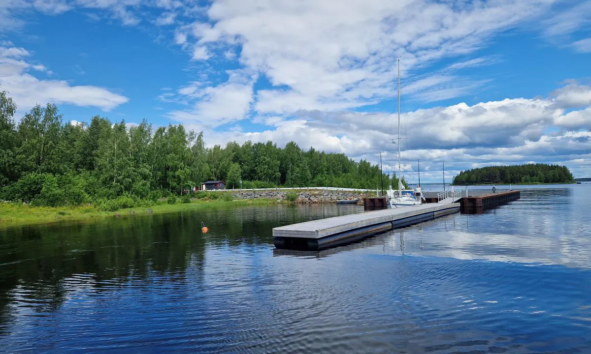
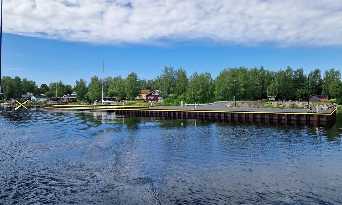
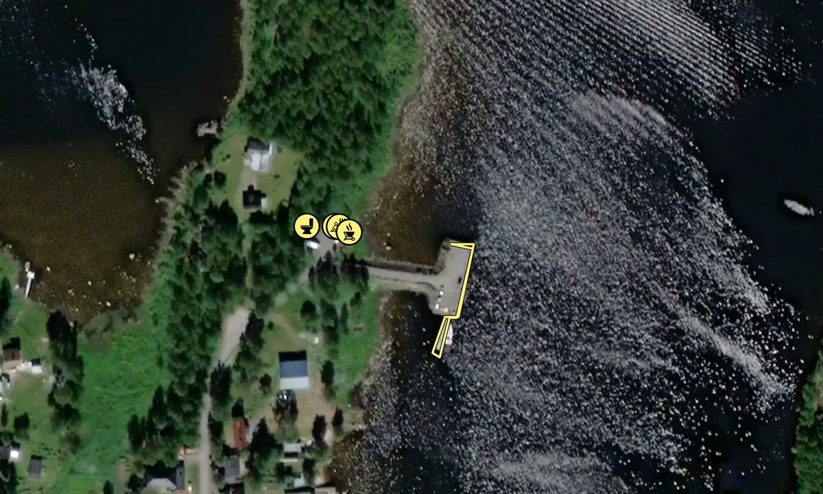
The harbour shape is a big surprising as it consists of a T shape ferry like quay and a long wooden pontoon. It does not look like a Gästhamn and has no sign or flag visible from a distance. Once on the pontoon you will find the booking QR-Code.
You moor along side either on one of the 2 free sides of the T or on either side of the long wooden pontoon. Depth is >3m.
The T quay was made for larger working boats and is high (1.1m) and not very friendly to yacht fenders. The wooden pontoon is more classic.
The you will find water and electricity at the pontoon (a long cable might be required depending where you moor).
Facilities include 1 hot shower, 1 toilet, 1 washing up point and 1 Sauna (to be booked as extra).
A grocery shop is available 700m up the road.

1 x helpful | written on 4. Jul 2025

HarbourMaps (site admin) says:

description

Harbour depth: 4 m, Guest berths: 8, Mooring: anchor/alongside

[translated from Swedish with AI]

0 x helpful | written on 14. Jul 2022

Do you know this harbour? It's a huge help to other sailors if you add a short description or review of the harbour.

📜 Add description

Map of Seskarö Leppäniemikajen

Facilities

Available facilities: Shore power, Fresh water, Shower, Toilet.

Updated on 14. Jul 2022. Update facilities.

Mooring

We don't have any data on how to moor in this harbour. If you know how to moor here, please update this site to help your fellow sailors. Update mooring.

Wind protection

Protection next night

85 points

N E S W --> } } } } } } } } } } } } } } } } } } } } } } } } } } } } } } } } } } } } } } } } } } } } } } } } } } } } } } } } } } } } } } } } } } } } } } } } } } } } } } } } } } } } } } } } } } } } } } } } } } } } } } } } } } } } } } } } } } } } } } } } } } } } } } } } } } } } } } } } } } } } } } } } } } } } } } } } } } } } } } } } } } } } } } } } } } } } } } } } } } } } } } } } } } } } } } } } } } } } } } } } } } } } } } } } } } } } } } } } } } } } } } } } } } } } } } } } } } } } } } } } } } } } } } } } } } } } } } } } } } } } } } } } } } } } } } } } } } } } } } } } } } } } } } } } } } } } } } } } } } } } } } } } } } } } } } } } } } } } } } } } } } } } } } } } } } } } } } } } } } } } } } } } } } } } } } } } } } } } } } } } } } } } } } } } } } } } } } } } } } } } } } } } } } } } } } } } } } } } } } } } } } } } } } } } } } } } } } } } } } } } } } } } } } } } } } } } } } } } } } } } } } } } } } } } } } } } } } } } } } } } } } } } } } } } } } } } } } } } } } } } } } } } } } } } } } } } } } } } } } } } } } } } } } } } } } } } } } } } } } } } } } } } } } } } } } } } } } } } } } } } } } } } } } } } } } } } } } } } } } } } } } } } } } } } } } } } } } } } } } } } } } } } } } } } } } } } } } } } } } } } } } } } } } } } } } } } } } } } } } } } } } } } } } } } } } } } } } } } } } } } } } } } } } } } } } } } } } } } } } } } } } } } } } } } } } } } } } } } } } } } } } } } } } } } } } } } } } } } } } } } } } } } } } } } } } } } } } } } } } } } } } } } } } } } } } } } } } } } } } } } } } } } } } } } } } } } } } } } } } } } } } } } } } } } } } } } } } } } } } } } } } } } } } } } } } } } } } } } } } } } } } } } } } } } } } } } } } } } } } } } } } } } } } } } } } } } } } } } } } } } } } } } } } } } } } } } } } } } } } } } } } } } } } } } } } } } } } } } } } } } } } } } } } } } } } } } } } } } } } } } } } } } } } } } } } } } } } } } } } } } } } } } } } } } } } } } } } } } } } } } } } } } } } } } } } } } } } } } } } } } } } } } } } } } } } } } } } } } } } } } Next night 0:00 6:00 12:00 Tor 10 Jul 18:00 0:00 6:00 12:00 Fre 11 Jul 3m/s 1m/s

Want to know how the wind score works? Then you should read this explanation.

The wind forecasts come from yr.no (Norwegian Meteorological Institute), and was last updated 2 hours and 15 minutes ago (Wednesday 09 July 11:27 PM). The next night score shows you the worst hour between 22:00 and 08:00 the next night. We recommend that you check multiple sources for wind forecasts. windy.com is a good website to show larger wind systems.

The safe wind directions for this harbour has been decided by an algorithm, based on how elevated the land around the harbour is. It's mostly correct, but sometimes the underlying data about elevation levels is not good enough to make correct decisions. It's a great help to other if you can validate or adjust the safe wind directions. You can see the data used by the algorithm to decide the safe wind directions by clicking here.

Last visits to Seskarö Leppäniemikajen

The visits are retrieved from AIS data. You can click to see all visiting ships to Seskarö Leppäniemikajen, as well as statistics about the ships that visits

Add this harbour to a journey

Check in now

Choose a different date than today

Important: When you check in to a harbour, you add it to a journey on this website. You are not booking a place in the marina.

Contributors

Users that contributed to this page: Dominig ar Foll

harbourmaps.com is updated by the boating community. When you add information, a review or pictures to this page you are listed here with the other contributors (we list your user-name, which can be your real name or a pseudonym).

Closest harbours to Seskarö Leppäniemikajen

Filter by

Natural harbour
Marina
Safe wind next night

Order by

ABC
Popularity
Wind score next night

0 harbours

Show more harbours