























Stavoren gratis ligplaats

Natural harbour

favoritt

Region: Netherlands (588), Friesland (110), IJsselmeer (54), Súdwest-Fryslân (48), Nijefurd (23) and Stavoren (9)

Stavoren gratis ligplaats: {"base": "nl", "no": "Vandruterute til Hindeloopen.", "se": "Vandringsled till Hindeloopen.", "en": "Walking route to Hindeloopen.", "da": "Vandrute til Hindeloopen.", "fr": "Itin\u00e9raire de randonn\u00e9e vers Hindeloopen.", "de": "Wanderweg nach Hindeloopen.", "es": "Ruta de senderismo a Hindeloopen.", "it": "Percorso a piedi per Hindeloopen.", "pt": "Rota de caminhada para Hindeloopen.", "nl": "Wandelroute naar Hindeloopen.", "pl": "Trasa spacerowa do Hindeloopen.", "uk": "\u041f\u0440\u043e\u0433\u0443\u043b\u044f\u043d\u043a\u043e\u0432\u0438\u0439 \u043c\u0430\u0440\u0448\u0440\u0443\u0442 \u0434\u043e \u0425\u0456\u043d\u0434\u0435\u043b\u043e\u043f\u0435\u043d\u0430.", "ro": "Traseu de promenad\u0103 c\u0103tre Hindeloopen.", "tr": "Hindeloopen'a Y\u00fcr\u00fcy\u00fc\u015f Rotas\u0131.", "el": "\u0394\u03b9\u03b1\u03b4\u03c1\u03bf\u03bc\u03ae \u03c0\u03b5\u03b6\u03bf\u03c0\u03bf\u03c1\u03af\u03b1\u03c2 \u03c0\u03c1\u03bf\u03c2 \u03c4\u03bf \u03a7\u03af\u03bd\u03c4\u03b5\u03bb\u03bf\u03c0\u03b5\u03bd.", "cs": "P\u011b\u0161\u00ed trasa do Hindeloopenu.", "hu": "S\u00e9ta\u00fatvonal Hindeloopen fel\u00e9.", "fi": "K\u00e4velyreitti Hindeloopeniin.", "bg": "\u041f\u0435\u0448\u0435\u0445\u043e\u0434\u0435\u043d \u043c\u0430\u0440\u0448\u0440\u0443\u0442 \u043a\u044a\u043c \u0425\u0438\u043d\u0434\u0435\u043b\u043e\u043e\u043f\u0435\u043d.", "sr": "\u041f\u0443\u0442\u0430\u045a\u0430 \u0437\u0430 \u043f\u0435\u0448\u0430\u0447\u0435\u045a\u0435 \u043a\u0430 \u0425\u0438\u043d\u0434\u0435\u043b\u043e\u0443\u043f\u0435\u043d\u0443.", "et": "K\u00e4igutee Hindeloopenisse.", "lv": "Pastaigu mar\u0161ruts uz Hindeloopen", "lt": "P\u0117s\u010di\u0173j\u0173 mar\u0161rutas \u012f Hindeloopen\u0105."}
Satelite image of Stavoren gratis ligplaats

📸 Upload a photo

Show off your photos and help others plan their journey to Stavoren gratis ligplaats.harbourmaps.com is created by the sailing community, in a collective effort to make cruising simpler and more fun. Uploading a photo takes less than a minutes and can be done from your phone, tablet or laptop.

📸 Upload a photo

Facilities

Available facilities: Swimming area.

Updated on 19. Aug 2026. Update facilities.

Mooring

Options for mooring in this harbour: To pier/wharf, Anchoring, Towards land.

Updated on 19. Aug 2026. Update mooring.

Descriptions and reviews

Aegir says:

area

maritime qualities

description

A sturdy pier on the outer side of the marina where you can moor for three nights free of charge. The pier can sometimes be slippery and there may be a lot of bird droppings. Reasonably well protected against all wind directions, only with strong south and west winds there may be some swell in the harbour basin.

A short walk (15 minutes) to get to Stavoren. A small authentic town with a train station. A beautiful walk (10 km) can be made along the IJsselmeer dike to Hindeloopen (also an old town). From here you can take the train back to Stavoren.

[translated from Dutch with AI]

1 x helpful | written on 18. Aug 2026

Do you know this harbour? It's a huge help to other sailors if you add a short description or review of the harbour.

📜 Add description

Map of Stavoren gratis ligplaats

Facilities

Available facilities: Swimming area.

Updated on 19. Aug 2026. Update facilities.

Mooring

Options for mooring in this harbour: To pier/wharf, Anchoring, Towards land.

Updated on 19. Aug 2026. Update mooring.

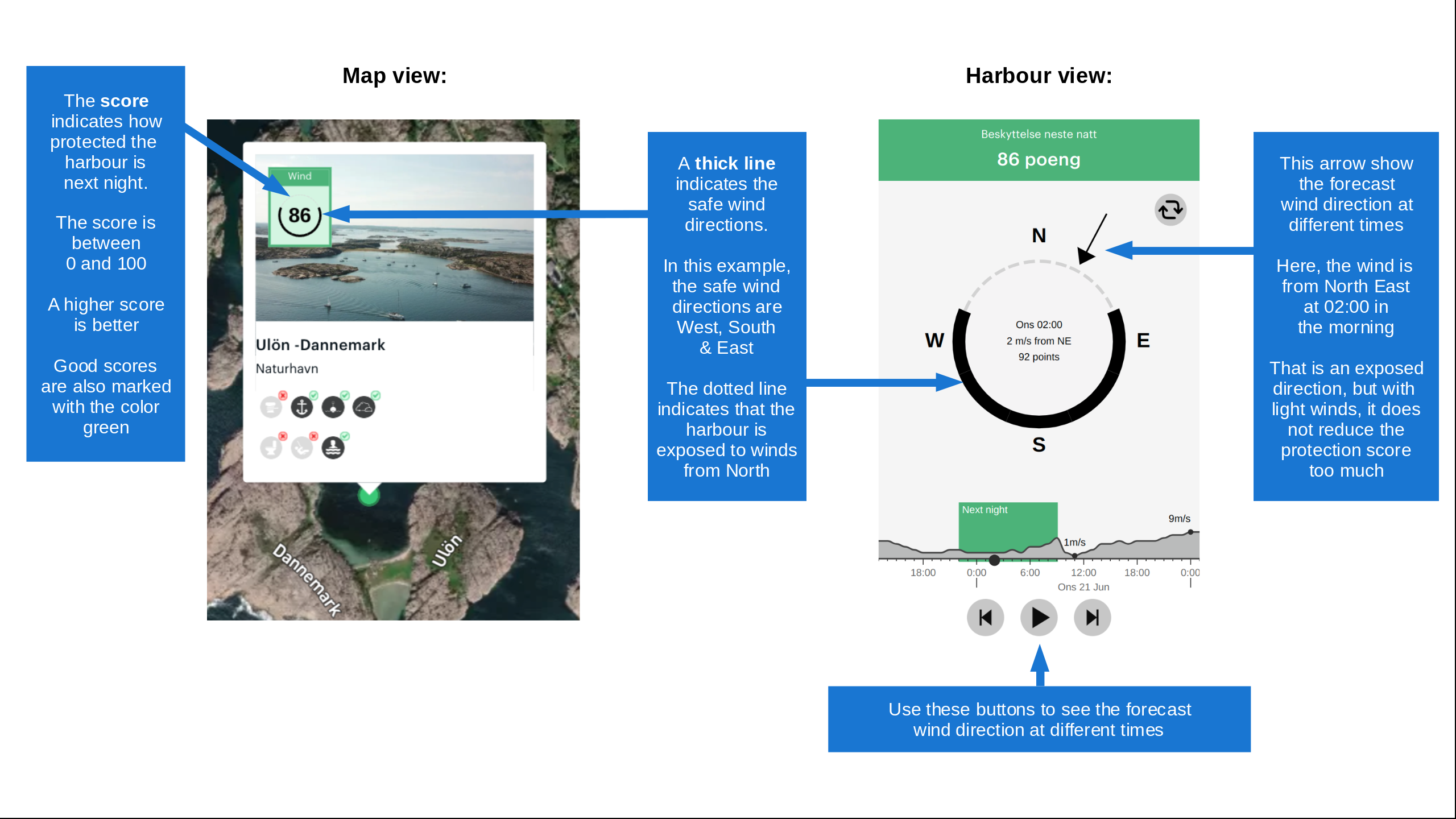
Wind protection

Protection next night

95 points

N E S W --> } } } } } } } } } } } } } } } } } } } } } } } } } } } } } } } } } } } } } } } } } } } } } } } } } } } } } } } } } } } } } } } } } } } } } } } } } } } } } } } } } } } } } } } } } } } } } } } } } } } } } } } } } } } } } } } } } } } } } } } } } } } } } } } } } } } } } } } } } } } } } } } } } } } } } } } } } } } } } } } } } } } } } } } } } } } } } } } } } } } } } } } } } } } } } } } } } } } } } } } } } } } } } } } } } } } } } } } } } } } } } } } } } } } } } } } } } } } } } } } } } } } } } } } } } } } } } } } } } } } } } } } } } } } } } } } } } } } } } } } } } } } } } } } } } } } } } } } } } } } } } } } } } } } } } } } } } } } } } } } } } } } } } } } } } } } } } } } } } } } } } } } } } } } } } } } } } } } } } } } } } } } } } } } } } } } } } } } } } } } } } } } } } } } } } } } } } } } } } } } } } } } } } } } } } } } } } } } } } } } } } } } } } } } } } } } } } } } } } } } } } } } } } } } } } } } } } } } } } } } } } } } } } } } } } } } } } } } } } } } } } } } } } } } } } } } } } } } } } } } } } } } } } } } } } } } } } } } } } } } } } } } } } } } } } } } } } } } } } } } } } } } } } } } } } } } } } } } } } } } } } } } } } } } } } } } } } } } } } } } } } } } } } } } } } } } } } } } } } } } } } } } } } } } } } } } } } } } } } } } } } } } } } } } } } } } } } } } } } } } } } } } } } } } } } } } } } } } } } } } } } } } } } } } } } } } } } } } } } } } } } } } } } } } } } } } } } } } } } } } } } } } } } } } } } } } } } } } } } } } } } } } } } } } } } } } } } } } } } } } } } } } } } } } } } } } } } } } } } } } } } } } } } } } } } } } } } } } } } } } } } } } } } } } } } } } } } } } } } } } } } } } } } } } } } } } } } } } } } } } } } } } } } } } } } } } } } } } } } } } } } } } } } } } } } } } } } } } } } } } } } } } } } } } } } } } } } } } } } } } } } } } } } } } } } } } } } } } } } } } } } } } } } } } } } } } } } } } } } } } } } } } } } } } } } } } } } } } } } } } } } } } } } } } } } } } } } } } } } } } } } } } } } } } } } } } } } } } } } } } } Next night 12:00 Tor 19 Nov 18:00 0:00 6:00 12:00 Fre 20 Nov 18:00 7m/s 1m/s

Want to know how the wind score works? Then you should read this explanation.

The wind forecasts come from yr.no (Norwegian Meteorological Institute), and was last updated 2 hours and 9 minutes ago (Thursday 19 November 10:32 AM). The next night score shows you the worst hour between 22:00 and 08:00 the next night. We recommend that you check multiple sources for wind forecasts. windy.com is a good website to show larger wind systems.

The safe directions for this harbour was added at 19. Aug 2026. Click here to edit.

Last visits to Stavoren gratis ligplaats

Thu 22 Oct 2026

MA BELLE [MMSI: 211161390]

Thu 15 Oct 2026

BAGHEERA [MMSI: 244100995]

Thu 01 Oct 2026

KAGOU [MMSI: 261006441]

Wed 30 Sep 2026

BRISK [MMSI: 244650405]

Mon 28 Sep 2026

IDEFIX [MMSI: 244110991]

The visits are retrieved from AIS data. You can click to see all visiting ships to Stavoren gratis ligplaats, as well as statistics about the ships that visits

Add this harbour to a journey

Check in now

Choose a different date than today

Important: When you check in to a harbour, you add it to a journey on this website. You are not booking a place in the marina.

Contributors

Users that contributed to this page: Aegir

harbourmaps.com is updated by the boating community. When you add information, a review or pictures to this page you are listed here with the other contributors (we list your user-name, which can be your real name or a pseudonym).

Closest harbours to Stavoren gratis ligplaats

Filter by

Natural harbour
Marina
Safe wind next night

Order by

ABC
Popularity
Wind score next night

0 harbours

Show more harbours