Nordåsvannet Marmorøyene

Natural harbour

favoritt

Region: Norway (3278), Vestland (579), Hordaland (375) and Bergen (20)

Nordåsvannet Marmorøyene: {"base": "no", "no": "Ilandstigningsbrygge og sm\u00e5b\u00e5tbrygge p\u00e5 \u00f8stsiden. Gangbroer mellom \u00f8yene.", "se": "Landstigningsbrygga och sm\u00e5b\u00e5tsbrygga p\u00e5 \u00f6stsidan. G\u00e5ngbroar mellan \u00f6arna.", "en": "Landing pier and small boat dock on the east side. Walkways between the islands.", "da": "Landgangsbrygge og sm\u00e5b\u00e5dsbro p\u00e5 \u00f8stsiden. Gangbroer mellem \u00f8erne."}
Nordåsvannet Marmorøyene: {"base": "no", "no": "Flere fine lune viker.", "se": "Flera fina lugna vikar.", "en": "Several fine sheltered coves.", "da": "Flere fine lune vige."}
Nordåsvannet Marmorøyene: {"base": "no", "no": "Bolter i fjellet for dregg fort\u00f8yning og noen steder longside mot fjellet.", "se": "Bultar i berget f\u00f6r ankardragning och p\u00e5 vissa st\u00e4llen l\u00e4ngs sidan mot berget.", "en": "Bolts in the rock for anchor mooring and in some places alongside the rock.", "da": "Bolte i klippen til ankring med h\u00e6kanker og nogle steder langside mod klippen."}
Nordåsvannet Marmorøyene: {"base": "no", "no": "Sm\u00e5b\u00e5t brygge og ilandstigningsbrygge p\u00e5 \u00f8stsiden.", "se": "Sm\u00e5b\u00e5tsbrygga och landstigningsbrygga p\u00e5 \u00f6stsidan.", "en": "Small boat dock and landing quay on the east side.", "da": "Lilleb\u00e5dsbro og landgangsbro p\u00e5 \u00f8stsiden."}
Satelite image of Nordåsvannet Marmorøyene

📸 Upload a photo

Show off your photos and help others plan their journey to Nordåsvannet Marmorøyene.harbourmaps.com is created by the sailing community, in a collective effort to make cruising simpler and more fun. Uploading a photo takes less than a minutes and can be done from your phone, tablet or laptop.

📸 Upload a photo

Facilities

Available facilities: Toilet, Playground, Swimming area.

Updated on 23. May 2022. Update facilities.

Mooring

Options for mooring in this harbour: Anchoring, Towards land.

Updated on 23. May 2022. Update mooring.

Descriptions and reviews

TESO says:

description

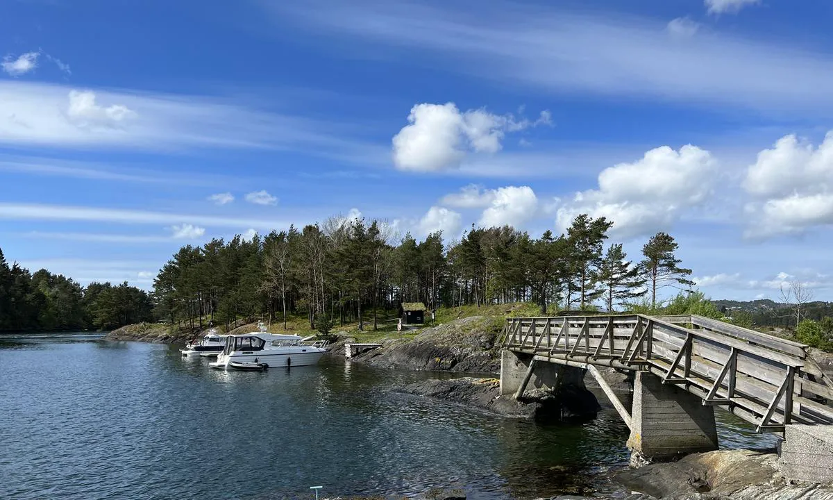
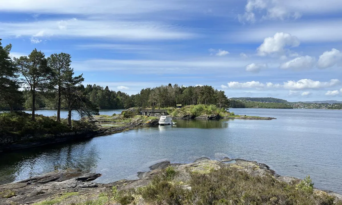
Approach and maritime conditions: The Marble Islands are located in the middle of Nordåsvannet, accessible via the current at Straume from Dolviken/Grimstadfjorden.

In the current, the water speeds up to 5-6 knots depending on the tide. Otherwise easily accessible without significant obstacles.

Due to the Straumebro bridge, this place is not suitable for sailboats.
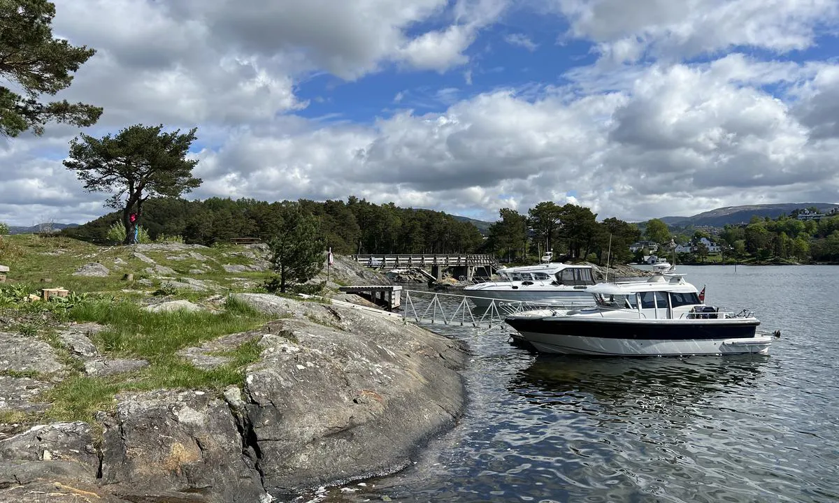
Anchorage: Mooring is primarily done with an anchor towards the shore, but smaller boats (under 26 feet) can dock at the floating pier, though it is only suitable for shorter stays.

Bolts in the rock are found in several places, mainly in the area around the bridges.
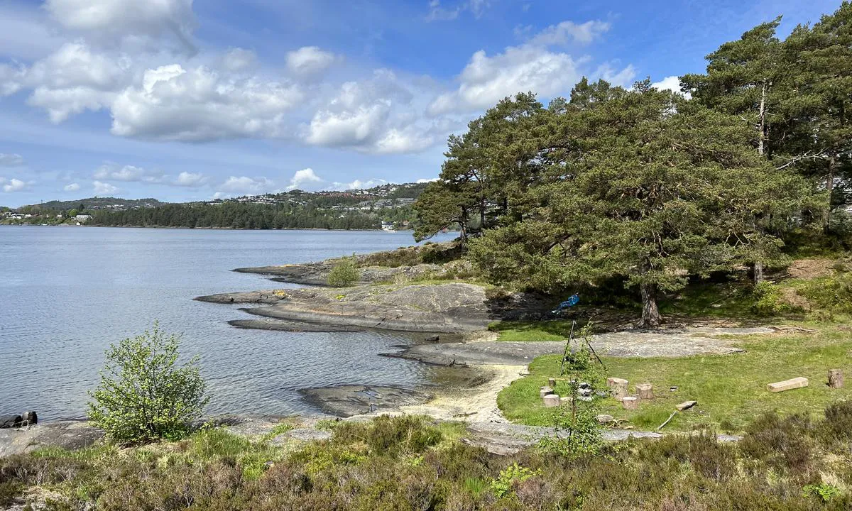
The area: Recreational area managed by BOF.

Nice swimming bays, rocky outcrops, grassy meadows, shelters, diving boards, footbridges, and good paths in the forest.

An interesting island as there were marble quarries in older times that, among other things, supplied marble to Christianborg Palace in Copenhagen.

The island also has a beech forest.

[translated from Norwegian with AI]

1 x helpful | written on 23. May 2022

Do you know this harbour? It's a huge help to other sailors if you add a short description or review of the harbour.

📜 Add description

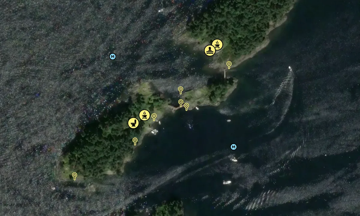
Map of Nordåsvannet Marmorøyene

Facilities

Available facilities: Toilet, Playground, Swimming area.

Updated on 23. May 2022. Update facilities.

Mooring

Options for mooring in this harbour: Anchoring, Towards land.

Updated on 23. May 2022. Update mooring.

Wind protection

Protection next night

91 points

N E S W --> } } } } } } } } } } } } } } } } } } } } } } } } } } } } } } } } } } } } } } } } } } } } } } } } } } } } } } } } } } } } } } } } } } } } } } } } } } } } } } } } } } } } } } } } } } } } } } } } } } } } } } } } } } } } } } } } } } } } } } } } } } } } } } } } } } } } } } } } } } } } } } } } } } } } } } } } } } } } } } } } } } } } } } } } } } } } } } } } } } } } } } } } } } } } } } } } } } } } } } } } } } } } } } } } } } } } } } } } } } } } } } } } } } } } } } } } } } } } } } } } } } } } } } } } } } } } } } } } } } } } } } } } } } } } } } } } } } } } } } } } } } } } } } } } } } } } } } } } } } } } } } } } } } } } } } } } } } } } } } } } } } } } } } } } } } } } } } } } } } } } } } } } } } } } } } } } } } } } } } } } } } } } } } } } } } } } } } } } } } } } } } } } } } } } } } } } } } } } } } } } } } } } } } } } } } } } } } } } } } } } } } } } } } } } } } } } } } } } } } } } } } } } } } } } } } } } } } } } } } } } } } } } } } } } } } } } } } } } } } } } } } } } } } } } } } } } } } } } } } } } } } } } } } } } } } } } } } } } } } } } } } } } } } } } } } } } } } } } } } } } } } } } } } } } } } } } } } } } } } } } } } } } } } } } } } } } } } } } } } } } } } } } } } } } } } } } } } } } } } } } } } } } } } } } } } } } } } } } } } } } } } } } } } } } } } } } } } } } } } } } } } } } } } } } } } } } } } } } } } } } } } } } } } } } } } } } } } } } } } } } } } } } } } } } } } } } } } } } } } } } } } } } } } } } } } } } } } } } } } } } } } } } } } } } } } } } } } } } } } } } } } } } } } } } } } } } } } } } } } } } } } } } } } } } } } } } } } } } } } } } } } } } } } } } } } } } } } } } } } } } } } } } } } } } } } } } } } } } } } } } } } } } } } } } } } } } } } } } } } } } } } } } } } } } } } } } } } } } } } } } } } } } } } } } } } } } } } } } } } } } } } } } } } } } } } } } } } } } } } } } } } } } } } } } } } } } } } } } } } } } } } } } } } } } } } } } } } } } } } } } } } } } } } } } } } } } } } } } } } } } } } } } } } } } } } } } } } } } } } } } Next night 18:00 0:00 6:00 12:00 Tor 01 Mai 18:00 0:00 6m/s 1m/s

Want to know how the wind score works? Then you should read this explanation.

The wind forecasts come from yr.no (Norwegian Meteorological Institute), and was last updated 1 hour and 29 minutes ago (Wednesday 30 April 03:28 PM). The next night score shows you the worst hour between 22:00 and 08:00 the next night. We recommend that you check multiple sources for wind forecasts. windy.com is a good website to show larger wind systems.

The safe directions for this harbour was added at 23. May 2022. Click here to edit.

Last visits to Nordåsvannet Marmorøyene

Mon 04 Sep 2023

MARIA [MMSI: 259003770]

Wed 16 Aug 2023

SOPHIE [MMSI: 259005500]

Thu 13 Jul 2023

SOPHIE [MMSI: 259005500]

The visits are retrieved from AIS data. You can click to see all visiting ships to Nordåsvannet Marmorøyene, as well as statistics about the ships that visits

Add this harbour to a journey

Check in now

Choose a different date than today

Important: When you check in to a harbour, you add it to a journey on this website. You are not booking a place in the marina.

Contributors

Users that contributed to this page: TESO

harbourmaps.com is updated by the boating community. When you add information, a review or pictures to this page you are listed here with the other contributors (we list your user-name, which can be your real name or a pseudonym).

Closest harbours to Nordåsvannet Marmorøyene

Filter by

Natural harbour
Marina
Safe wind next night

Order by

ABC
Popularity
Wind score next night

0 harbours

Show more harbours