Mensaje del sistema: Please log in to access this page.

Ortmühle

Puerto natural

favoritt

Region: Germany (727), Schleswig-Holstein (129) and Fehmarn (8)

Ortmühle: {"base": "no", "no": "Man kan se til Fehmarnsundet og brua fra ankerplassen. Bildet her er tatt p\u00e5 vei gjennom sundet og under brua. Brua har oppgitt en h\u00f8yde p\u00e5 21m. P\u00e5 h\u00f8yre brokaret, sett fra nord, er det merket 20,21 og 22m avhengig av vannstand. Alt over vannlinja gjelder. Det er liten tidevannsforskjell her.", "se": "Man kan se till Fehmarnsundet och bron fr\u00e5n ankringsplatsen. Bilden h\u00e4r \u00e4r tagen p\u00e5 v\u00e4g genom sundet och under bron. Bron har en angiven h\u00f6jd p\u00e5 21 m. P\u00e5 h\u00f6ger brokista, sedd fr\u00e5n norr, \u00e4r det markerat 20, 21 och 22 m beroende p\u00e5 vattenst\u00e5nd. Allt \u00f6ver vattenlinjen g\u00e4ller. Det \u00e4r liten skillnad i tidvatten h\u00e4r.", "en": "You can see the Fehmarn Sound and the bridge from the anchorage. The picture here is taken on the way through the sound and under the bridge. The bridge has a stated height of 21m. On the right bridge pier, seen from the north, it is marked 20, 21 and 22m depending on the water level. All heights above the waterline apply. There is a small tidal difference here.", "da": "Man kan se til Femernsundet og broen fra ankerpladsen. Billedet her er taget p\u00e5 vej gennem sundet og under broen. Broen har angivet en h\u00f8jde p\u00e5 21m. P\u00e5 h\u00f8jre brokar, set fra nord, er der markeret 20, 21 og 22m afh\u00e6ngigt af vandstand. Alt over vandlinjen g\u00e6lder. Der er lille tidevandforskel her."}
Ortmühle: {"base": "no", "no": "Utsikt nordover og over innseilingen til Heiligenhafen.", "se": "Utsikt norrut och \u00f6ver infarten till Heiligenhafen.", "en": "View northwards and over the approach to Heiligenhafen.", "da": "Udsigt nordover og over indsejlingen til Heiligenhafen."}
Satelite image of Ortmühle

📸 Sube una foto

Muestra tus fotos y ayuda a otros a planificar su viaje a Ortmühle.harbourmaps.com es creado por la comunidad de navegación, en un esfuerzo colectivo para hacer la navegación más simple y divertida. Subir una foto toma menos de un minuto y se puede hacer desde tu teléfono, tableta o portátil.

📸 Sube una foto

Instalaciones

No tenemos ningún dato sobre las instalaciones disponibles en este puerto. Si sabes qué instalaciones están disponibles aquí, por favor actualiza este sitio para ayudar a tus compañeros navegantes. Actualizar instalaciones.

Amarre

No tenemos datos sobre cómo amarrar en este puerto. Si sabes cómo amarrar aquí, por favor actualiza este sitio para ayudar a tus compañeros navegantes. Actualizar amarre.

Descripciones y reseñas

Elisabeth Jåsund dice:

área

cualidades marítimas

descripción

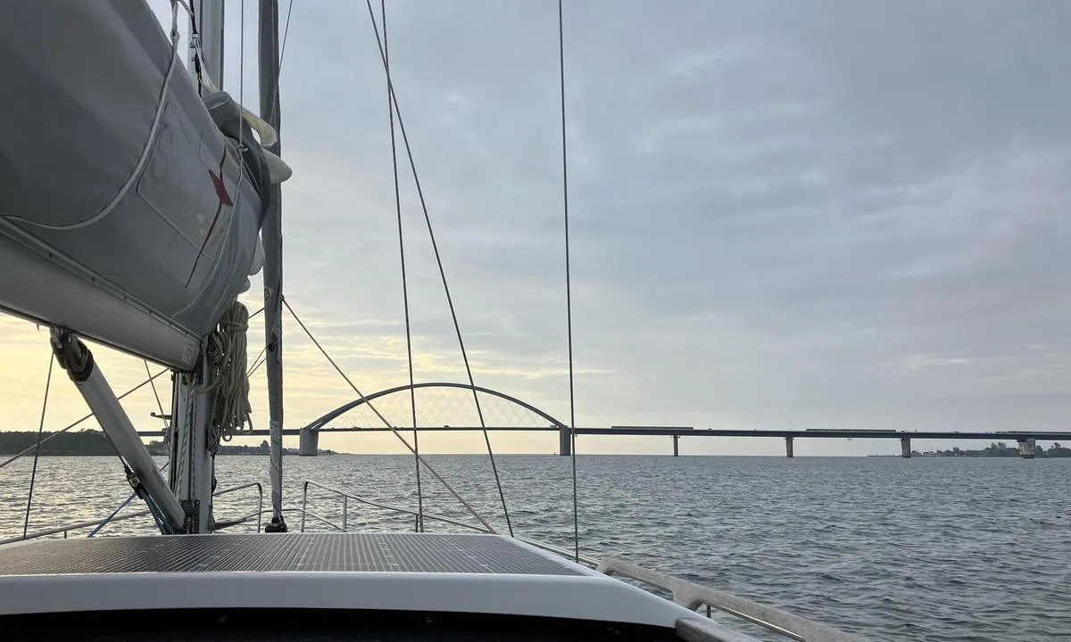
Lugar excelente para fondear. Este era el marcador de anclaje más externo en el mapa. Profundidad de alrededor de 8 m. Un poco cerca de la boya verde de entrada a Heiligenhafen, pero no fue un problema. Lugar magnífico para fondear. Tuvimos viento de 4-6 m/s desde el suroeste. Buen agarre, el ancla se fijó inmediatamente. En algunos lugares puede haber algo de algas marinas.

[translated from Norwegian with AI]

1 x helpful | written on 8. Jun 2024

¿Conoces este puerto? Es de gran ayuda para otros marineros si añades una breve descripción o reseña del puerto.

📜 Añadir descripción

Mapa de Ortmühle

Instalaciones

No tenemos ningún dato sobre las instalaciones disponibles en este puerto. Si sabes qué instalaciones están disponibles aquí, por favor actualiza este sitio para ayudar a tus compañeros navegantes. Actualizar instalaciones.

Amarre

No tenemos datos sobre cómo amarrar en este puerto. Si sabes cómo amarrar aquí, por favor actualiza este sitio para ayudar a tus compañeros navegantes. Actualizar amarre.

Protección contra el viento

Protección próxima noche

88 puntos

N E S W --> } } } } } } } } } } } } } } } } } } } } } } } } } } } } } } } } } } } } } } } } } } } } } } } } } } } } } } } } } } } } } } } } } } } } } } } } } } } } } } } } } } } } } } } } } } } } } } } } } } } } } } } } } } } } } } } } } } } } } } } } } } } } } } } } } } } } } } } } } } } } } } } } } } } } } } } } } } } } } } } } } } } } } } } } } } } } } } } } } } } } } } } } } } } } } } } } } } } } } } } } } } } } } } } } } } } } } } } } } } } } } } } } } } } } } } } } } } } } } } } } } } } } } } } } } } } } } } } } } } } } } } } } } } } } } } } } } } } } } } } } } } } } } } } } } } } } } } } } } } } } } } } } } } } } } } } } } } } } } } } } } } } } } } } } } } } } } } } } } } } } } } } } } } } } } } } } } } } } } } } } } } } } } } } } } } } } } } } } } } } } } } } } } } } } } } } } } } } } } } } } } } } } } } } } } } } } } } } } } } } } } } } } } } } } } } } } } } } } } } } } } } } } } } } } } } } } } } } } } } } } } } } } } } } } } } } } } } } } } } } } } } } } } } } } } } } } } } } } } } } } } } } } } } } } } } } } } } } } } } } } } } } } } } } } } } } } } } } } } } } } } } } } } } } } } } } } } } } } } } } } } } } } } } } } } } } } } } } } } } } } } } } } } } } } } } } } } } } } } } } } } } } } } } } } } } } } } } } } } } } } } } } } } } } } } } } } } } } } } } } } } } } } } } } } } } } } } } } } } } } } } } } } } } } } } } } } } } } } } } } } } } } } } } } } } } } } } } } } } } } } } } } } } } } } } } } } } } } } } } } } } } } } } } } } } } } } } } } } } } } } } } } } } } } } } } } } } } } } } } } } } } } } } } } } } } } } } } } } } } } } } } } } } } } } } } } } } } } } } } } } } } } } } } } } } } } } } } } } } } } } } } } } } } } } } } } } } } } } } } } } } } } } } } } } } } } } } } } } } } } } } } } } } } } } } } } } } } } } } } } } } } } } } } } } } } } } } } } } } } } } } } } } } } } } } } } } } } } } } } } } } } } } } } } } } } } } } } } } } } } } } } } } } } } } } } } } } } } } } } } } } } } } } } } } } } } } } } } } } } } } Next night 12:00 Tor 08 Mai 18:00 0:00 6:00 12:00 Fre 09 Mai 18:00 0:00 7m/s 1m/s

¿Quieres saber cómo funciona la puntuación del viento? Entonces deberías leer esta explicación.

Las previsiones del viento provienen de yr.no (Instituto Meteorológico Noruego), y se actualizaron por última vez 1 hour and 41 minutes ago (Jueves 08 Mayo 11:27). La siguiente puntuación nocturna te muestra la peor hora entre las 22:00 y las 08:00 de la siguiente noche. Recomendamos que consultes varias fuentes para los pronósticos de viento.windy.com es un buen sitio web para mostrar sistemas eólicos más grandes.

Las direcciones de viento seguras para este puerto han sido decididas por un algoritmo, basado en la elevación del terreno alrededor del puerto. Es mayormente correcto, pero a veces los datos subyacentes sobre los niveles de elevación no son lo suficientemente buenos para tomar decisiones correctas. Es de gran ayuda para otros si puedes validar o ajustar las direcciones del viento seguro. You can see the data used by the algorithm to decide the safe wind directions by clicking here.

Last visits to Ortmühle

Mar 27 Ago 2024

FREYJA [MMSI: 211463160]

Mié 14 Ago 2024

BIGWIG [MMSI: 211368800]

Vie 19 Jul 2024

SALTWATER [MMSI: 211669660]

VELASSARU [MMSI: 211346980]

Lun 08 Jul 2024

VELASSARU [MMSI: 211346980]

The visits are retrieved from AIS data. You can click to see all visiting ships to Ortmühle, as well as statistics about the ships that visits

Añadir este puerto a un viaje

Regístrate ahora

Elija una fecha diferente a la de hoy

Importante: Cuando inicias sesión en un puerto, lo agregas a un viaje en este sitio web. No estás reservando un lugar en la marina.

Colaboradores

Usuarios que contribuyeron a esta página: Elisabeth Jåsund

harbourmaps.com es actualizado por la comunidad de navegantes. Cuando agregas información, una revisión o fotos a esta página, te enumeramos aquí con los otros contribuyentes (listamos tu nombre de usuario, que puede ser tu nombre real o un seudónimo).

Puertos más cercanos a Ortmühle

Filtrar por

Puerto natural
Marina
Viento seguro la próxima noche

Ordenar por

ABC
Popularidad
Puntuación de viento próxima noche

0 puertos

Mostrar más puertos