Saltsprøytene (Skratta)

Natural harbour

favoritt

Region: Norway (3278), Vestfold og Telemark (229), Telemark (59), Kragerø (36) and Skåtøy (16)

Saltsprøytene (Skratta): {"base": "no", "no": "\u00c5pent inn fra s\u00f8r-vest for sj\u00f8 og rester av ha d\u00f8nninger. Mulig \u00e5 ligge longside for seilb\u00e5t som p\u00e5 bildet (obs 1,3 meteren rett ved siden av). Mange bolter syd/bak seilb\u00e5ten. Og mange bolter p\u00e5 oddene rundt i bukta", "se": "\u00d6ppet in fr\u00e5n sydv\u00e4st f\u00f6r sj\u00f6 och kvarvarande svall. M\u00f6jligt att ligga l\u00e5ngsides f\u00f6r segelb\u00e5t som p\u00e5 bilden (observera 1,3 meter precis bredvid). M\u00e5nga bultar syd/bakom segelb\u00e5ten. Och m\u00e5nga bultar p\u00e5 uddar runt bukten.", "en": "Open from the southwest for sea and residual ocean swells. Possible to dock alongside for a sailboat as shown in the picture (note the 1.3 meter depth right next to it). Many bolts to the south/behind the sailboat. And many bolts on the points around the bay.", "da": "\u00c5bent ind fra sydvest for s\u00f8 og rester af b\u00f8lged\u00f8nninger. Muligt at ligge langskibs for sejlskib som p\u00e5 billedet (bem\u00e6rk 1,3 meter lige ved siden af). Mange bolte syd/bag sejlskibet. Og mange bolte p\u00e5 odderne rundt i bugten."}
Saltsprøytene (Skratta): {"base": "no", "no": "Nose inn mulig for seilb\u00e5ter p\u00e5 berget til h\u00f8yre i bildet (Skratta holmen). Ogs\u00e5 mulig nose inn og en longside mot Saltspr\u00f8ytene (obs 1,3 meteren)", "se": "Nose in m\u00f6jligt f\u00f6r segelb\u00e5tar p\u00e5 berget till h\u00f6ger i bilden (Skratta holmen). Ocks\u00e5 m\u00f6jligt nose in och en l\u00e5ngsida mot Saltspruten (obs 1,3 meter).", "en": "Nose in possible for sailboats on the rock to the right in the picture (Skratta holmen). Also possible to nose in and alongside Saltspr\u00f8ytene (beware of the 1.3 meters)", "da": "N\u00e6se ind muligt for sejlb\u00e5de p\u00e5 klippen til h\u00f8jre i billedet (Skratta holmen). Ogs\u00e5 muligt n\u00e6se ind og en langside mod Saltspr\u00f8jtet (obs 1,3 meteren)"}
Satelite image of Saltsprøytene (Skratta)

📸 Upload a photo

Show off your photos and help others plan their journey to Saltsprøytene (Skratta).harbourmaps.com is created by the sailing community, in a collective effort to make cruising simpler and more fun. Uploading a photo takes less than a minutes and can be done from your phone, tablet or laptop.

📸 Upload a photo

Facilities

Available facilities: Toilet.

Updated on 17. Aug 2023. Update facilities.

Mooring

Options for mooring in this harbour: Towards land.

Updated on 17. Aug 2023. Update mooring.

Descriptions and reviews

Snorre Smith says:

area

maritime qualities

description

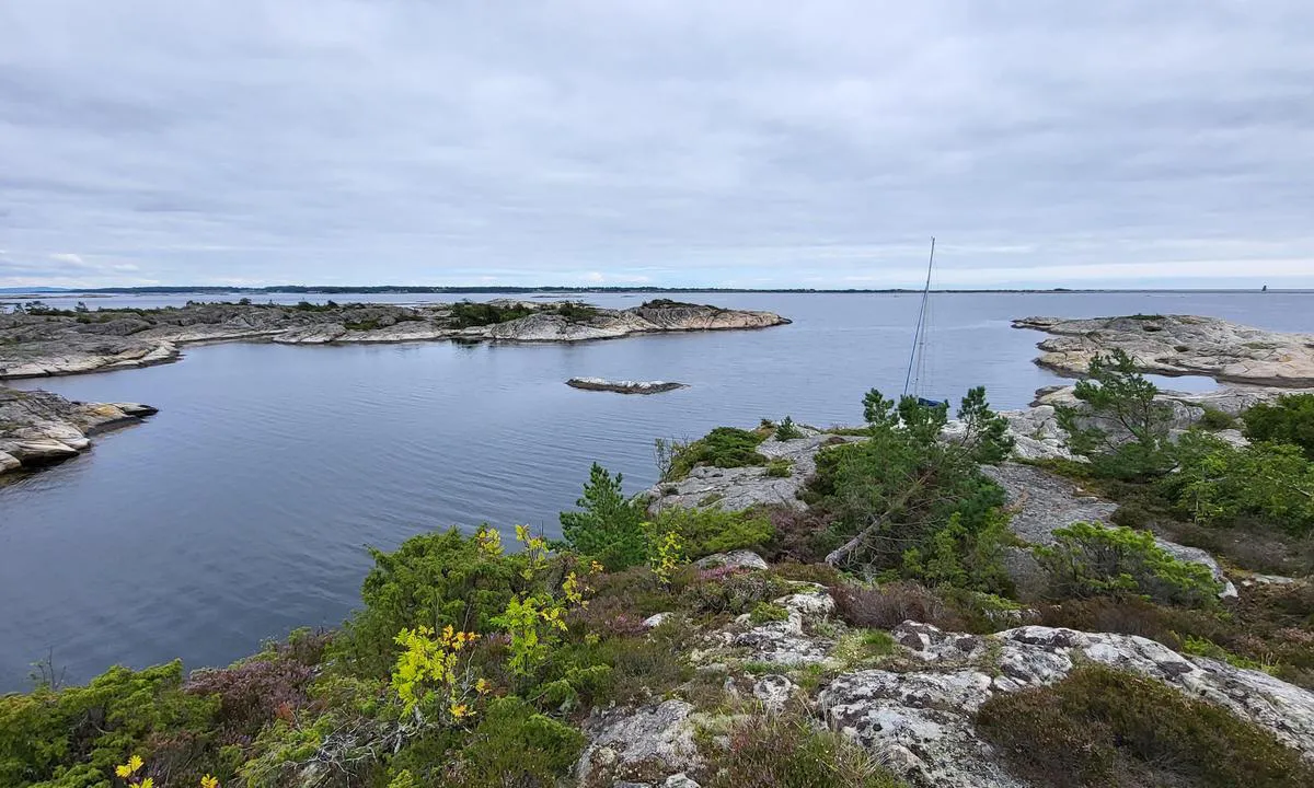
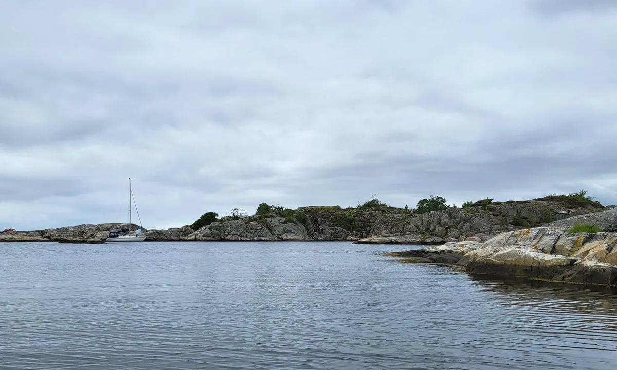
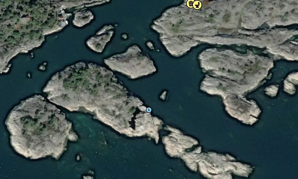
Best approach from the southwest. Several reefs, so follow the nautical chart closely. Be especially aware of the wash reef / 0.5 meters on the port side when following the deepest channel. Also, be cautious of the 1.3-meter depth between the small islet in the middle and all the bolts towards the south/west (Saltsprøytene). This 1.3-meter area extends several meters outwards with slightly more depth, though still shallow for sailboats. It is also possible to sail in from the northwest. Narrow between reefs, but good depth. Follow the chart. Very exposed to wind from all directions. Waves coming in from the southwest. Plenty of “nose in” spots with bolts for motorboats. “Nose in” and a longside possible for sailboats towards Saltsprøytene. “Nose in” also possible for sailboats at the northernmost part of this bay towards one of the Skrattaholmen.

[translated from Norwegian with AI]

1 x helpful | written on 17. Aug 2023

Do you know this harbour? It's a huge help to other sailors if you add a short description or review of the harbour.

📜 Add description

Map of Saltsprøytene (Skratta)

Facilities

Available facilities: Toilet.

Updated on 17. Aug 2023. Update facilities.

Mooring

Options for mooring in this harbour: Towards land.

Updated on 17. Aug 2023. Update mooring.

Wind protection

Protection next night

92 points

N E S W --> } } } } } } } } } } } } } } } } } } } } } } } } } } } } } } } } } } } } } } } } } } } } } } } } } } } } } } } } } } } } } } } } } } } } } } } } } } } } } } } } } } } } } } } } } } } } } } } } } } } } } } } } } } } } } } } } } } } } } } } } } } } } } } } } } } } } } } } } } } } } } } } } } } } } } } } } } } } } } } } } } } } } } } } } } } } } } } } } } } } } } } } } } } } } } } } } } } } } } } } } } } } } } } } } } } } } } } } } } } } } } } } } } } } } } } } } } } } } } } } } } } } } } } } } } } } } } } } } } } } } } } } } } } } } } } } } } } } } } } } } } } } } } } } } } } } } } } } } } } } } } } } } } } } } } } } } } } } } } } } } } } } } } } } } } } } } } } } } } } } } } } } } } } } } } } } } } } } } } } } } } } } } } } } } } } } } } } } } } } } } } } } } } } } } } } } } } } } } } } } } } } } } } } } } } } } } } } } } } } } } } } } } } } } } } } } } } } } } } } } } } } } } } } } } } } } } } } } } } } } } } } } } } } } } } } } } } } } } } } } } } } } } } } } } } } } } } } } } } } } } } } } } } } } } } } } } } } } } } } } } } } } } } } } } } } } } } } } } } } } } } } } } } } } } } } } } } } } } } } } } } } } } } } } } } } } } } } } } } } } } } } } } } } } } } } } } } } } } } } } } } } } } } } } } } } } } } } } } } } } } } } } } } } } } } } } } } } } } } } } } } } } } } } } } } } } } } } } } } } } } } } } } } } } } } } } } } } } } } } } } } } } } } } } } } } } } } } } } } } } } } } } } } } } } } } } } } } } } } } } } } } } } } } } } } } } } } } } } } } } } } } } } } } } } } } } } } } } } } } } } } } } } } } } } } } } } } } } } } } } } } } } } } } } } } } } } } } } } } } } } } } } } } } } } } } } } } } } } } } } } } } } } } } } } } } } } } } } } } } } } } } } } } } } } } } } } } } } } } } } } } } } } } } } } } } } } } } } } } } } } } } } } } } } } } } } } } } } } } } } } } } } } } } } } } } } } } } } } } } } } } } } } } } } } } } } } } } } } } } } } } } } } } } } } } } } } } } } } } } } } } } } } } } } } } } } } } } } } } } } } Next night 18:00 0:00 6:00 12:00 Tor 01 Mai 18:00 0:00 10m/s 0m/s

Want to know how the wind score works? Then you should read this explanation.

The wind forecasts come from yr.no (Norwegian Meteorological Institute), and was last updated 2 hours and 14 minutes ago (Wednesday 30 April 02:28 PM). The next night score shows you the worst hour between 22:00 and 08:00 the next night. We recommend that you check multiple sources for wind forecasts. windy.com is a good website to show larger wind systems.

The safe directions for this harbour was added at 17. Aug 2023. Click here to edit.

Saltsprøytene (Skratta) and/or the surrounding seas is not well protected from strong winds and waves, and you should take caution in foul weather. Click to edit protection level.

Last visits to Saltsprøytene (Skratta)

Wed 26 Jul 2023

ARIEL II [MMSI: 258109760]

Wed 19 Jul 2023

POLLY-ESTHER [MMSI: 258201980]

The visits are retrieved from AIS data. You can click to see all visiting ships to Saltsprøytene (Skratta), as well as statistics about the ships that visits

Add this harbour to a journey

Check in now

Choose a different date than today

Important: When you check in to a harbour, you add it to a journey on this website. You are not booking a place in the marina.

Contributors

Users that contributed to this page: Snorre Smith

harbourmaps.com is updated by the boating community. When you add information, a review or pictures to this page you are listed here with the other contributors (we list your user-name, which can be your real name or a pseudonym).

Closest harbours to Saltsprøytene (Skratta)

Filter by

Natural harbour
Marina
Safe wind next night

Order by

ABC
Popularity
Wind score next night

0 harbours

Show more harbours