Sundholmene

Natural harbour

favoritt

Region: Norway (3424), Vestfold og Telemark (229), Telemark (68) and Kragerø (39)

Sundholmene: {"base": "no", "no": "Havnen er ogs\u00e5 kalt Rekevika.\r\n\r\nHolmene p\u00e5 utsiden kalles Grisholmane men heter p\u00e5 kartet Sundaholmane.", "se": "Hamnens kallas ocks\u00e5 Rekevika.<br><br>Holmarna p\u00e5 utsidan kallas Grisholmarna men heter p\u00e5 kartan Sundaholmarna.", "en": "The harbour is also called Rekevika.<br><br>The islets on the outside are called Grisholmane, but are named Sundaholmane on the map.", "da": "Havnen er ogs\u00e5 kaldet Rekevika.<br><br>Holmene p\u00e5 ydersiden kaldes Grisholmane, men hedder p\u00e5 kortet Sundaholmane."}
Sundholmene: {"base": "no", "no": "Fint bryggeanlegg", "se": "Fin brygganl\u00e4ggning", "en": "Nice dock facility", "da": "Fint broanl\u00e6g", "fr": "Beau syst\u00e8me de quai", "de": "Sch\u00f6nes Hafenanlagen", "es": "Bonitas instalaciones de muelle", "it": "Bel bel molo", "pt": "Belo cais", "nl": "Mooi aanlegsteiger", "pl": "\u0141adna infrastruktura nabrze\u017ca", "uk": "\u0413\u0430\u0440\u043d\u0430 \u043f\u0440\u0438\u0447\u0430\u043b\u044c\u043d\u0430 \u0441\u043f\u043e\u0440\u0443\u0434\u0430", "ro": "Facilit\u0103\u021bi frumoase de debarcare", "tr": "G\u00fczel bir iskele tesisi", "el": "\u03a9\u03c1\u03b1\u03af\u03b5\u03c2 \u03b5\u03b3\u03ba\u03b1\u03c4\u03b1\u03c3\u03c4\u03ac\u03c3\u03b5\u03b9\u03c2 \u03b1\u03c0\u03bf\u03b2\u03ac\u03b8\u03c1\u03b1\u03c2", "cs": "P\u011bkn\u00e9 p\u0159\u00edstavi\u0161t\u011b", "hu": "Sz\u00e9p kik\u00f6t\u0151 \u00e9p\u00edtm\u00e9ny", "fi": "Hieno laiturij\u00e4rjestelm\u00e4", "bg": "\u0425\u0443\u0431\u0430\u0432\u0430 \u043f\u0440\u0438\u0441\u0442\u0430\u043d\u0438\u0449\u043d\u0430 \u043a\u043e\u043d\u0441\u0442\u0440\u0443\u043a\u0446\u0438\u044f", "sr": "\u041b\u0435\u043f\u043e \u043f\u0440\u0438\u0441\u0442\u0430\u043d\u0438\u0448\u0442\u0435", "et": "Hea kai rajatis", "lv": "Laba piest\u0101tne", "lt": "Puikus prieplaukos \u012frenginys"}
Sundholmene
Sundholmene
Sundholmene: {"base": "no", "no": "Gresslette med flere benker.", "se": "Gr\u00e4splan med flera b\u00e4nkar.", "en": "Grass area with several benches.", "da": "Gr\u00e6spl\u00e6ne med flere b\u00e6nke.", "fr": "Pelouse avec plusieurs bancs.", "de": "Grasfl\u00e4che mit mehreren B\u00e4nken.", "es": "Zona de c\u00e9sped con varios bancos.", "it": "Prato con diverse panchine.", "pt": "Gramado com v\u00e1rios bancos.", "nl": "Grasveld met meerdere banken.", "pl": "Trawnik z kilkoma \u0142awkami.", "uk": "\u0422\u0440\u0430\u0432\u0430 \u0437 \u043a\u0456\u043b\u044c\u043a\u043e\u043c\u0430 \u043b\u0430\u0432\u043a\u0430\u043c\u0438.", "ro": "<p>Zona cu iarb\u0103 cu mai multe b\u0103nci.</p>", "tr": "\u00c7imenlik alan, bir\u00e7ok banka sahip.", "el": "\u039b\u03b9\u03b2\u03ac\u03b4\u03b9 \u03bc\u03b5 \u03c0\u03bf\u03bb\u03bb\u03ac \u03c0\u03b1\u03b3\u03ba\u03ac\u03ba\u03b9\u03b1.", "cs": "Travnat\u00e1 plocha s n\u011bkolika lavi\u010dkami.", "hu": "F\u00fcves ter\u00fclet t\u00f6bb paddal.", "fi": "Nurmi, jossa on useita penkkej\u00e4.", "bg": "\u0422\u0440\u0435\u0432\u043d\u0430 \u043f\u043b\u043e\u0449 \u0441 \u043d\u044f\u043a\u043e\u043b\u043a\u043e \u043f\u0435\u0439\u043a\u0438.", "sr": "\u0422\u0440\u0430\u0432\u043d\u0430\u0442\u0430 \u043f\u043e\u0432\u0440\u0448\u0438\u043d\u0430 \u0441\u0430 \u0432\u0438\u0448\u0435 \u043a\u043b\u0443\u043f\u0430.", "et": "Muruplats mitmete pinkidega.", "lv": "Z\u0101liena laukums ar vair\u0101kiem soli\u0146iem.", "lt": "\u017dolynas su keliais suolais."}
Sundholmene: {"base": "no", "no": "Utedo, sti til venstre opp bakken (bl\u00e5tt merke) ved benkene", "se": "Utedass, stig till v\u00e4nster uppf\u00f6r backen (bl\u00e5tt m\u00e4rke) vid b\u00e4nkarna", "en": "Outhouse, trail to the left up the hill (blue marker) by the benches", "da": "Ude-toilet, sti til venstre op ad bakken (bl\u00e5t m\u00e6rke) ved b\u00e6nkene", "fr": "Toilettes ext\u00e9rieures, sentier vers la gauche en montant la colline (marque bleue) pr\u00e8s des bancs", "de": "Plumpsklo, Weg nach links den H\u00fcgel hinauf (blaues Markierung) bei den B\u00e4nken", "es": "Ba\u00f1o exterior, sendero a la izquierda colina arriba (marca azul) junto a los bancos", "it": "Bagno esterno, sentiero a sinistra su per la collina (segnale blu) presso le panchine", "pt": "Sanit\u00e1rio, trilha \u00e0 esquerda subindo a colina (marca azul) perto dos bancos", "nl": "Buitentoilet, pad naar links de heuvel op (blauwe markering) bij de banken", "pl": "Toaleta na \u015bwie\u017cym powietrzu, \u015bcie\u017cka w lewo pod g\u00f3r\u0119 (niebieski znak) przy \u0142awkach", "uk": "\u0422\u0443\u0430\u043b\u0435\u0442 \u043d\u0430 \u0432\u0443\u043b\u0438\u0446\u0456, \u0441\u0442\u0435\u0436\u043a\u0430 \u043b\u0456\u0432\u043e\u0440\u0443\u0447 \u0432\u0433\u043e\u0440\u0443 \u043d\u0430 \u043f\u0430\u0433\u043e\u0440\u0431 (\u0441\u0438\u043d\u044f \u043c\u0456\u0442\u043a\u0430) \u0431\u0456\u043b\u044f \u043b\u0430\u0432\u043e\u043a", "ro": "Toalet\u0103 \u00een aer liber, poteca la st\u00e2nga \u00een susul dealului (marcaj albastru) l\u00e2ng\u0103 b\u0103nci", "tr": "A\u00e7\u0131k hava tuvaleti, banklar\u0131n yan\u0131nda soldaki patikadan yukar\u0131 (mavi i\u015faret)", "el": "\u0395\u03be\u03c9\u03c4\u03b5\u03c1\u03b9\u03ba\u03ae \u03c4\u03bf\u03c5\u03b1\u03bb\u03ad\u03c4\u03b1, \u03bc\u03bf\u03bd\u03bf\u03c0\u03ac\u03c4\u03b9 \u03c0\u03c1\u03bf\u03c2 \u03c4\u03b1 \u03b1\u03c1\u03b9\u03c3\u03c4\u03b5\u03c1\u03ac \u03b5\u03c0\u03ac\u03bd\u03c9 \u03c3\u03c4\u03bf\u03bd \u03bb\u03cc\u03c6\u03bf (\u03bc\u03c0\u03bb\u03b5 \u03c3\u03ae\u03bc\u03b1) \u03ba\u03bf\u03bd\u03c4\u03ac \u03c3\u03c4\u03bf\u03c5\u03c2 \u03c0\u03ac\u03b3\u03ba\u03bf\u03c5\u03c2", "cs": "Venku, stezka vlevo nahoru po svahu (modr\u00e1 zna\u010dka) u lavi\u010dek", "hu": "K\u00fcls\u0151 WC, \u00f6sv\u00e9ny balra fel a dombon (k\u00e9k jelz\u00e9s) a padokn\u00e1l", "fi": "Ulkovuorok\u00e4ym\u00e4l\u00e4, polku vasemmalle yl\u00f6s m\u00e4ke\u00e4 (sininen merkki) penkkien luona", "bg": "\u0412\u044a\u043d\u0448\u043d\u0430 \u0442\u043e\u0430\u043b\u0435\u0442\u043d\u0430, \u043f\u044a\u0442\u0435\u043a\u0430 \u043d\u0430\u043b\u044f\u0432\u043e \u043d\u0430\u0433\u043e\u0440\u0435 \u043f\u043e \u0441\u043a\u043b\u043e\u043d\u0430 (\u0441\u0438\u043d\u044f \u043c\u0430\u0440\u043a\u0438\u0440\u043e\u0432\u043a\u0430) \u043f\u0440\u0438 \u043f\u0435\u0439\u043a\u0438\u0442\u0435", "sr": "\u041f\u043e\u043b\u0443\u0442\u043e\u0430\u043b\u0435\u0442, \u0441\u0442\u0438\u045b\u0438 \u043b\u0435\u0432\u043e \u0443\u0437 \u0431\u0440\u0434\u043e (\u043f\u043b\u0430\u0432\u0430 \u043e\u0437\u043d\u0430\u043a\u0430) \u043a\u043e\u0434 \u043a\u043b\u0443\u043f\u0430", "et": "V\u00e4lik\u00e4imla, rada vasakule \u00fcles m\u00e4kke (sinine m\u00e4rk) pinkide juures", "lv": "\u0100ra tualete, ce\u013c\u0161 pa kreisi aug\u0161up pa kalnu (zila z\u012bme) pie soliem", "lt": "Lauko tualetas, takelis \u012f kair\u0119 \u012f kaln\u0105 (m\u0117lynas \u017eenklas) prie suoliuk\u0173"}
Satelite image of Sundholmene

📸 Upload a photo

Show off your photos and help others plan their journey to Sundholmene.harbourmaps.com is created by the sailing community, in a collective effort to make cruising simpler and more fun. Uploading a photo takes less than a minutes and can be done from your phone, tablet or laptop.

📸 Upload a photo

Facilities

Available facilities: Toilet, Playground, Swimming area.

Updated on 14. Jul 2023. Update facilities.

Mooring

Options for mooring in this harbour: To pier/wharf, Anchoring, Towards land.

Updated on 14. Jul 2023. Update mooring.

Descriptions and reviews

Anonymous sailor 200950 says:

area

maritime qualities

description

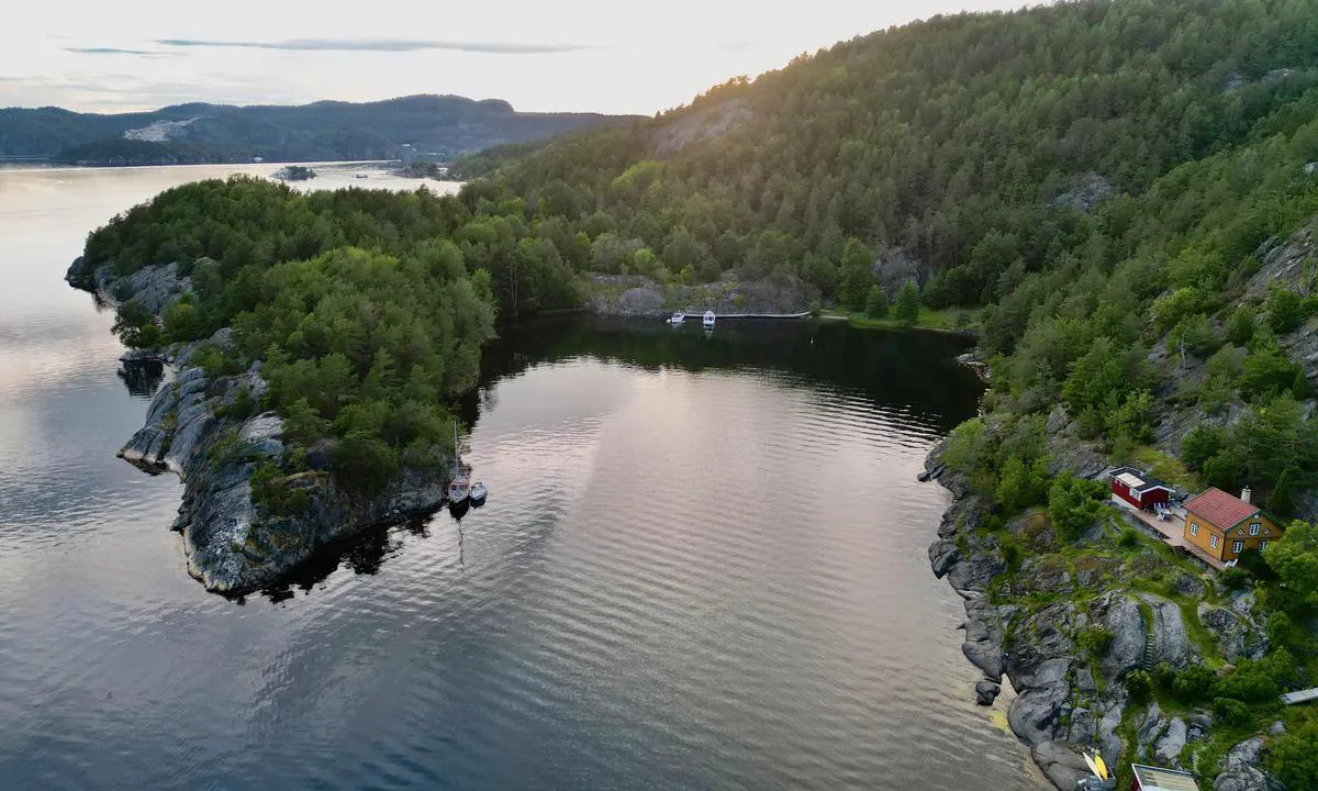
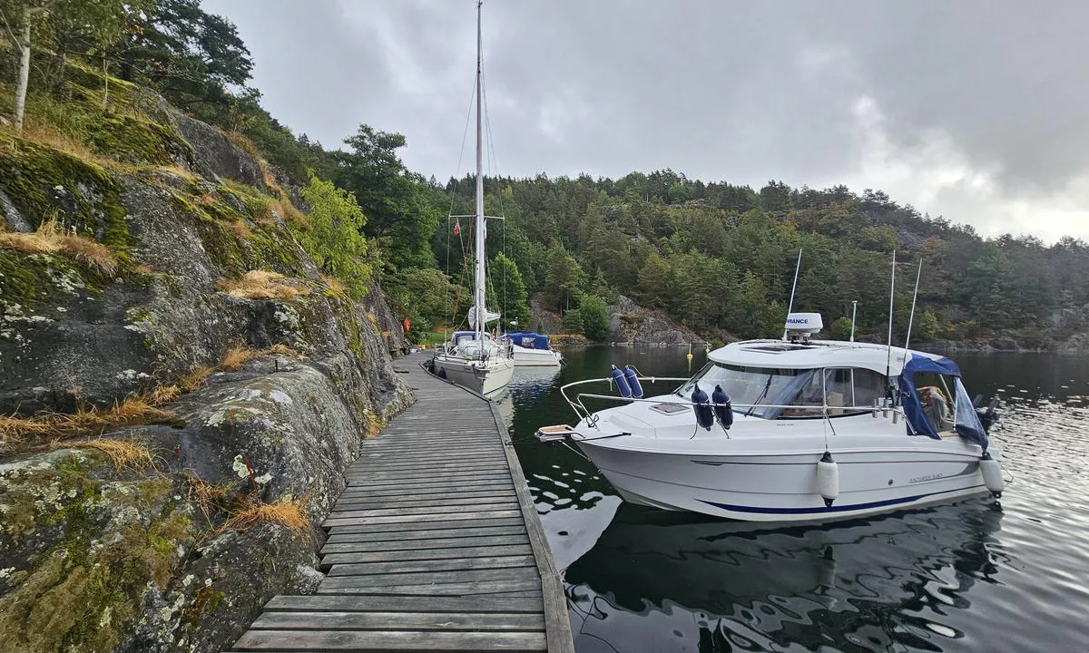
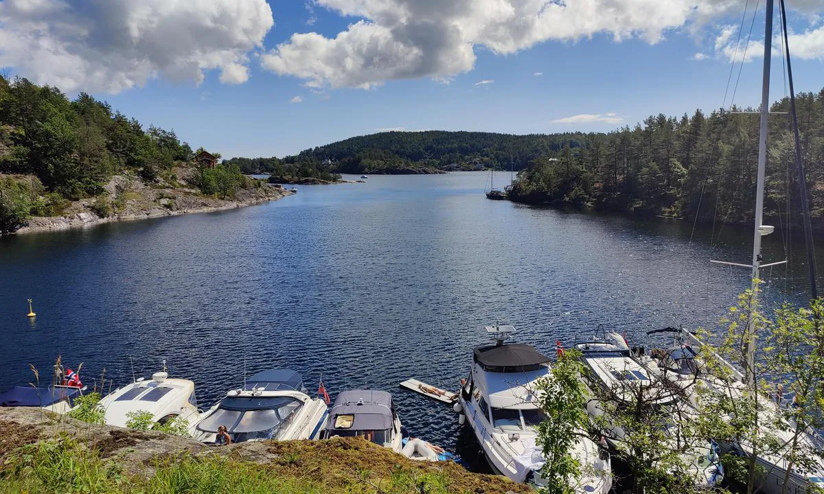
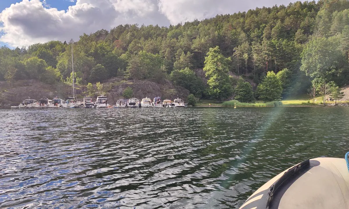
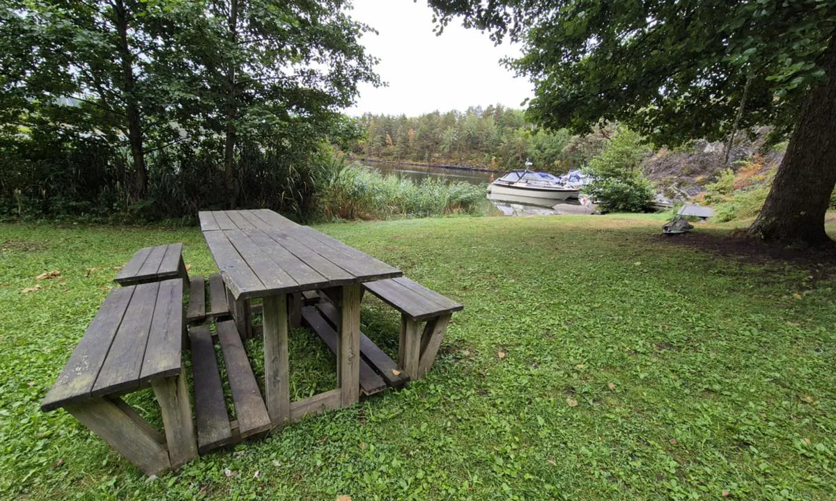
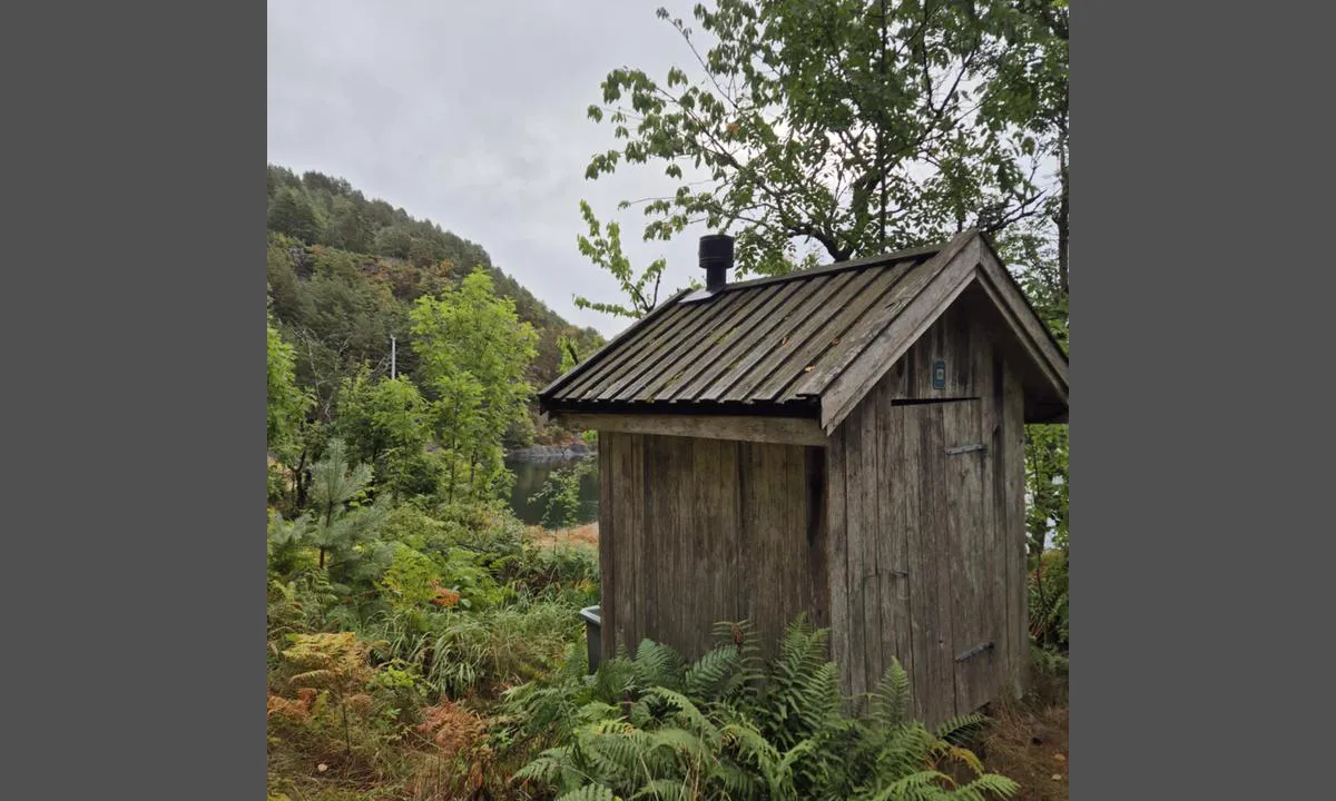
Great harbor near Kragerø. Deep next to the dock all the way. Bolts and alongside spots in the bay and on surrounding islands. Nice walking areas. Be aware of the ridge that runs lengthwise approximately in the middle of the bay, marked on the chart as two shoals at about 1m.

[translated from Norwegian with AI]

1 x helpful | written on 13. Jul 2023

Do you know this harbour? It's a huge help to other sailors if you add a short description or review of the harbour.
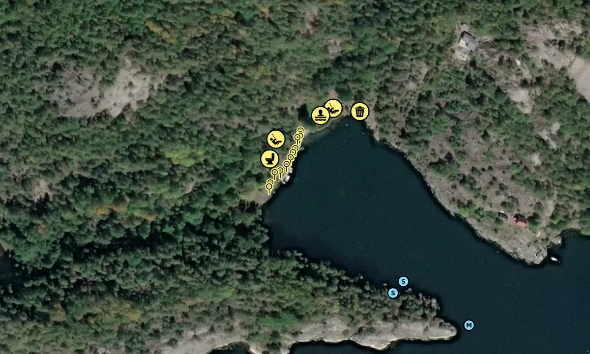
📜 Add description

Map of Sundholmene

Facilities

Available facilities: Toilet, Playground, Swimming area.

Updated on 14. Jul 2023. Update facilities.

Mooring

Options for mooring in this harbour: To pier/wharf, Anchoring, Towards land.

Updated on 14. Jul 2023. Update mooring.

Wind protection

Protection next night

89 points

N E S W --> } } } } } } } } } } } } } } } } } } } } } } } } } } } } } } } } } } } } } } } } } } } } } } } } } } } } } } } } } } } } } } } } } } } } } } } } } } } } } } } } } } } } } } } } } } } } } } } } } } } } } } } } } } } } } } } } } } } } } } } } } } } } } } } } } } } } } } } } } } } } } } } } } } } } } } } } } } } } } } } } } } } } } } } } } } } } } } } } } } } } } } } } } } } } } } } } } } } } } } } } } } } } } } } } } } } } } } } } } } } } } } } } } } } } } } } } } } } } } } } } } } } } } } } } } } } } } } } } } } } } } } } } } } } } } } } } } } } } } } } } } } } } } } } } } } } } } } } } } } } } } } } } } } } } } } } } } } } } } } } } } } } } } } } } } } } } } } } } } } } } } } } } } } } } } } } } } } } } } } } } } } } } } } } } } } } } } } } } } } } } } } } } } } } } } } } } } } } } } } } } } } } } } } } } } } } } } } } } } } } } } } } } } } } } } } } } } } } } } } } } } } } } } } } } } } } } } } } } } } } } } } } } } } } } } } } } } } } } } } } } } } } } } } } } } } } } } } } } } } } } } } } } } } } } } } } } } } } } } } } } } } } } } } } } } } } } } } } } } } } } } } } } } } } } } } } } } } } } } } } } } } } } } } } } } } } } } } } } } } } } } } } } } } } } } } } } } } } } } } } } } } } } } } } } } } } } } } } } } } } } } } } } } } } } } } } } } } } } } } } } } } } } } } } } } } } } } } } } } } } } } } } } } } } } } } } } } } } } } } } } } } } } } } } } } } } } } } } } } } } } } } } } } } } } } } } } } } } } } } } } } } } } } } } } } } } } } } } } } } } } } } } } } } } } } } } } } } } } } } } } } } } } } } } } } } } } } } } } } } } } } } } } } } } } } } } } } } } } } } } } } } } } } } } } } } } } } } } } } } } } } } } } } } } } } } } } } } } } } } } } } } } } } } } } } } } } } } } } } } } } } } } } } } } } } } } } } } } } } } } } } } } } } } } } } } } } } } } } } } } } } } } } } } } } } } } } } } } } } } } } } } } } } } } } } } } } } } } } } } } } } } } } } } } } } } } } } } } } } } } } } } } } } } } } } } } } } } } } } } } } Next night 0:00 6:00 12:00 Fre 19 Sep 18:00 0:00 6:00 5m/s 2m/s

Want to know how the wind score works? Then you should read this explanation.

The wind forecasts come from yr.no (Norwegian Meteorological Institute), and was last updated 2 hours and 1 minute ago (Thursday 18 September 07:27 PM). The next night score shows you the worst hour between 22:00 and 08:00 the next night. We recommend that you check multiple sources for wind forecasts. windy.com is a good website to show larger wind systems.

The safe directions for this harbour was added at 14. Jul 2023. Click here to edit.

Last visits to Sundholmene

Fri 21 Jul 2023

VIVE LA VIE [MMSI: 219031417]

Mon 17 Jul 2023

MY COCO [MMSI: 257022170]

The visits are retrieved from AIS data. You can click to see all visiting ships to Sundholmene, as well as statistics about the ships that visits

Add this harbour to a journey

Check in now

Choose a different date than today

Important: When you check in to a harbour, you add it to a journey on this website. You are not booking a place in the marina.

Contributors

Users that contributed to this page: Christian Torvetjønn, Kenneth Monsen and Anonymous sailor 200950

harbourmaps.com is updated by the boating community. When you add information, a review or pictures to this page you are listed here with the other contributors (we list your user-name, which can be your real name or a pseudonym).

Closest harbours to Sundholmene

Filter by

Natural harbour
Marina
Safe wind next night

Order by

ABC
Popularity
Wind score next night

0 harbours

Show more harbours