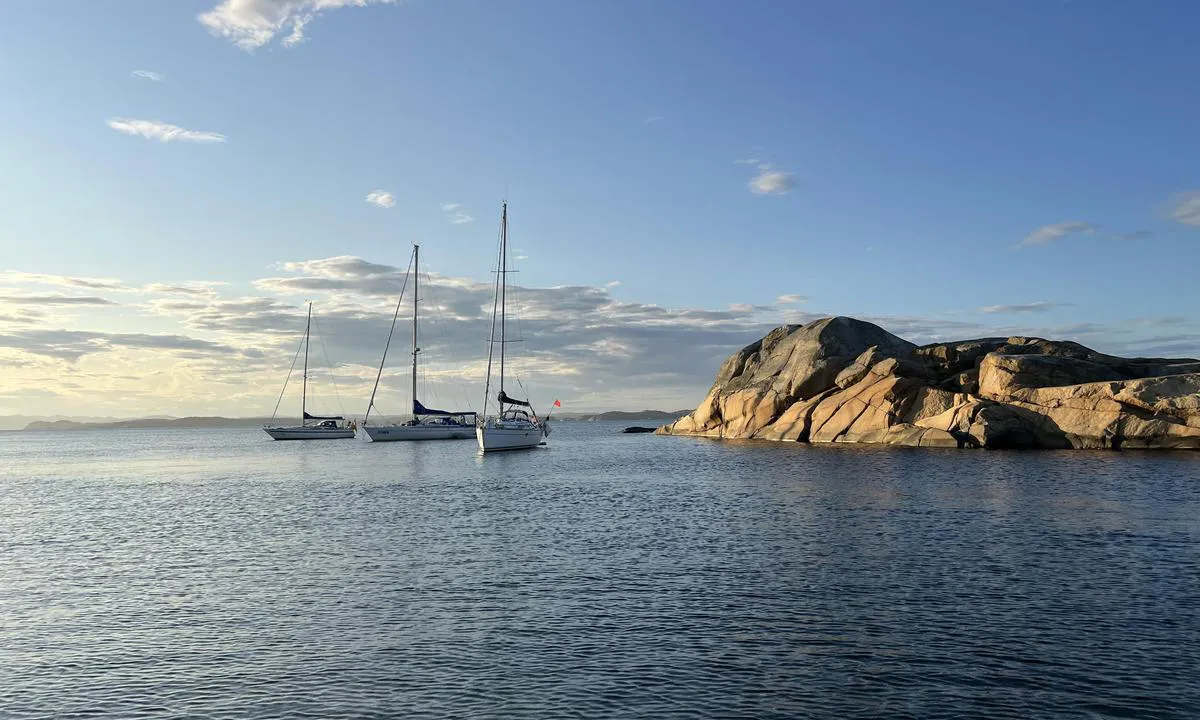
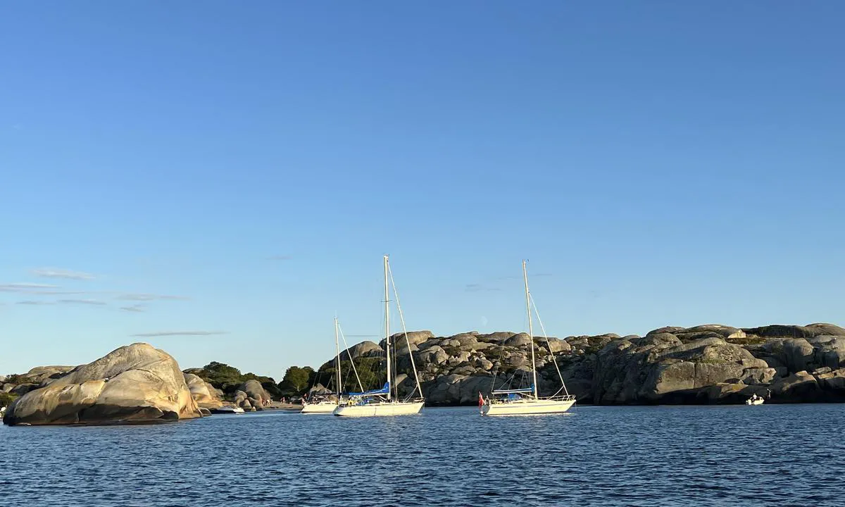
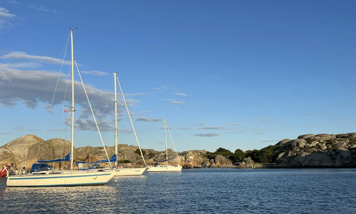
Message from the system: You need to be logged in to share images. You can either log in or create a new user.

Svennerfyr stranda

Natural harbour

favoritt

Region: Norway (3278), Vestfold og Telemark (229), Vestfold (169) and Larvik (32)

Svennerfyr stranda: {"base": "no", "no": "\u00c5pent ut mot nord/Larviksfjorden og Viksfjord. Uegnet ved nordlige vindretninger.", "se": "\u00d6ppet ut mot norr/Larviksfjorden och Viksfjorden. Ol\u00e4mpad vid nordliga vindriktningar.", "en": "Open towards the north/Larvik fjord and Viksfjord. Unsuitable in northerly wind directions.", "da": "\u00c5bent ud mod nord/Larviksfjorden og Viksfjord. Uegnet ved nordlige vindretninger."}
Svennerfyr stranda: {"base": "no", "no": "Nordbogen/Svennerstranden. Seilb\u00e5ter p\u00e5 svai, lengre inn er det bolter i fjellet og fort\u00f8yning i fjellet er mulig.", "se": "Nordbogen/Svennerstranden. Segelb\u00e5tar p\u00e5 svaj, l\u00e4ngre in finns det bultar i berget och f\u00f6rt\u00f6jning i berget \u00e4r m\u00f6jlig.", "en": "Nordbogen/Svennerstranden. Sailboats at anchor, further in there are bolts in the rock and mooring to the rock is possible.", "da": "Nordbogen/Svennerstranden. Sejlb\u00e5de p\u00e5 svaj, l\u00e6ngere inde er der bolte i fjeldet, og fort\u00f8jning i fjeldet er mulig."}
Svennerfyr stranda: {"base": "no", "no": "Nordbogen/Svennerstranden. Seilb\u00e5ter p\u00e5 svai, lengre inn er det bolter i fjellet og fort\u00f8yning i fjellet er mulig. Gode dybder langt inn. Sandbunn.", "se": "Nordbogen/Svennerstranden. Segelb\u00e5tar p\u00e5 svaj, l\u00e4ngre in finns det bultar i berget och f\u00f6rt\u00f6jning i berget \u00e4r m\u00f6jligt. Bra djup l\u00e5ngt in. Sandbotten.", "en": "Nordbogen/Svennerstranden. Sailboats at anchor, further in there are bolts in the rock and mooring to the rock is possible. Good depths quite far in. Sandy bottom.", "da": "Nordbogen/Svennerstranden. Sejlb\u00e5de for anker, l\u00e6ngere inde er der bolte i klippen og fort\u00f8jning i klippen er mulig. God dybde langt ind. Sandbund."}
Svennerfyr stranda: {"base": "no", "no": "Stranden innerst. Sti/gangvei opp under tr\u00e6rene midt i bildet, denne leder til fyrhavnen og fyret. Fort\u00f8yningsbolter i fjellet p\u00e5 \u00f8stsiden (venstre i bildet) av bukten.", "se": "Stranden innerst. Stig/g\u00e5ngv\u00e4g upp under tr\u00e4den mitt i bilden, denna leder till fyrhamnen och fyren. F\u00f6rt\u00f6jningsbultar i berget p\u00e5 \u00f6stra sidan (v\u00e4nster i bilden) av bukten.", "en": "The beach at the innermost part. Path/walkway up under the trees in the middle of the picture, leading to the lighthouse harbor and the lighthouse. Mooring bolts in the rock on the east side (left in the picture) of the bay.", "da": "Stranden inderst. Sti/gangsti op under tr\u00e6erne midt i billedet, denne f\u00f8rer til fyrhavnen og fyret. Fort\u00f8jningsbolte i klippen p\u00e5 \u00f8stsiden (venstre i billedet) af bugten."}
Svennerfyr stranda: {"base": "no", "no": "Sett fra innl\u00f8pet, \u00e5pent inn, en grunne er merket i kartet. V\u00e6r obs p\u00e5 at farvannet rundt Svenner generelt har mange grunner og skj\u00e6r. Disse er stortsett merket i kartet, men er ikke merket i terrenget.", "se": "Sett fr\u00e5n inloppet, \u00f6ppet in, en grund \u00e4r markerad p\u00e5 kartan. Var uppm\u00e4rksam p\u00e5 att vattnet runt Svenner generellt har m\u00e5nga grund och sk\u00e4r. Dessa \u00e4r mestadels markerade p\u00e5 kartan, men \u00e4r inte markerade i terr\u00e4ngen.", "en": "Seen from the entrance, open in, a shallow area is marked on the chart. Be aware that the waters around Svenner generally have many shallows and rocks. These are mostly marked on the chart, but are not marked in the terrain.", "da": "Set fra indl\u00f8bet, \u00e5bent ind, en grund er markeret p\u00e5 kortet. V\u00e6r opm\u00e6rksom p\u00e5, at farvandet rundt om Svenner generelt har mange grunde og sk\u00e6r. Disse er stort set markeret p\u00e5 kortet, men er ikke markeret i terr\u00e6net."}
Flyfoto av Svennerfyr stranda

📸 Upload a photo

Show off your photos and help others plan their journey to Svennerfyr stranda.harbourmaps.com is created by the sailing community, in a collective effort to make cruising simpler and more fun. Uploading a photo takes less than a minutes and can be done from your phone, tablet or laptop.

📸 Upload a photo

Facilities

Available facilities: Playground, Swimming area.

Updated on 10. Jul 2023. Update facilities.

Mooring

Options for mooring in this harbour: Anchoring, Towards land.

Updated on 10. Jul 2023. Update mooring.

Descriptions and reviews

TESO says:

area

maritime qualities

description

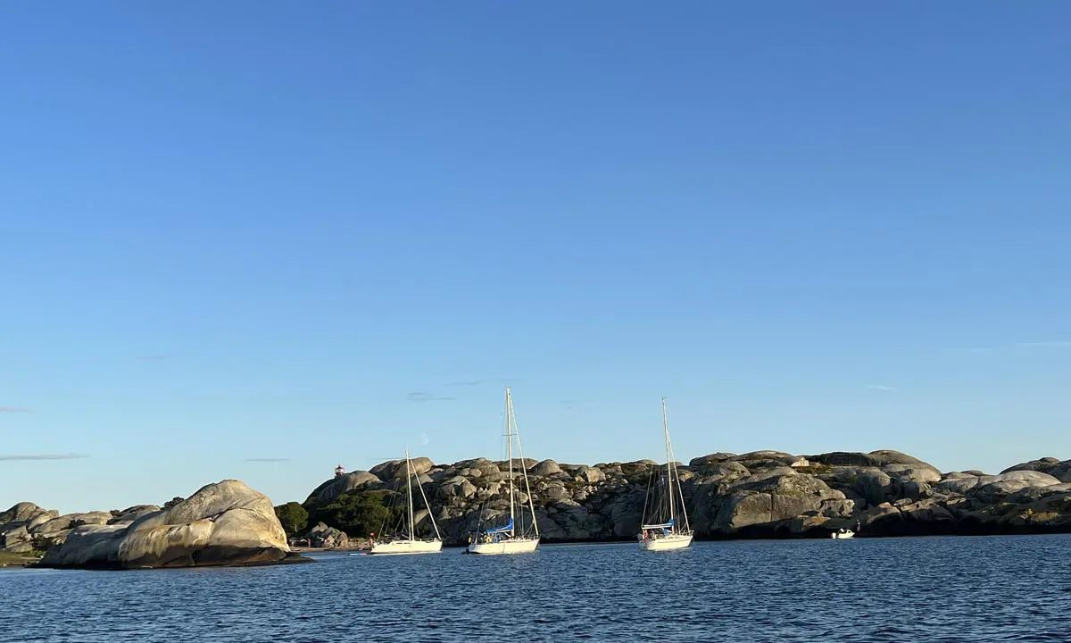
Easy access, but be aware that the area around Svenner is full of shallows and reefs. Most are marked on the map but not in the 'terrain'.

Sandy bottom and bolts in the rock.

Unsuitable for northern winds. With persistent strong winds, there can be some swell.

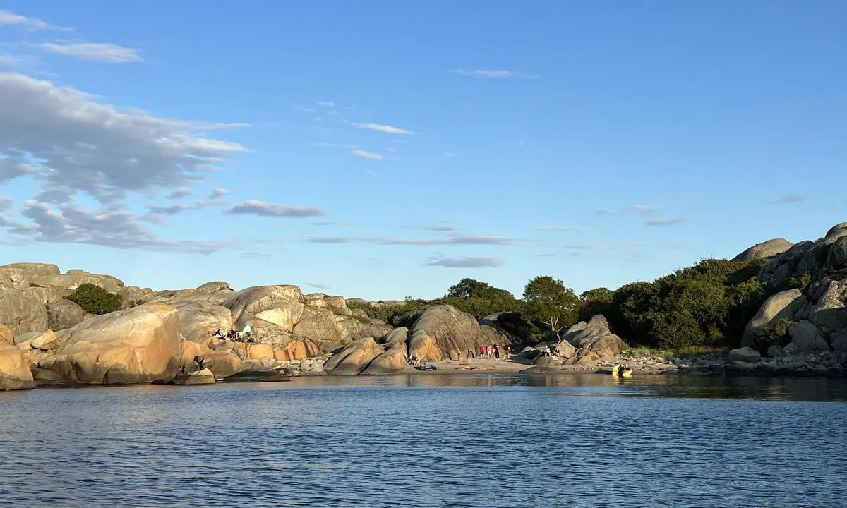
Beautiful lagoon with a child-friendly sandy beach. Footpath to Svenner lighthouse and the lighthouse harbor.

[translated from Norwegian with AI]

1 x helpful | written on 29. Jul 2023

Do you know this harbour? It's a huge help to other sailors if you add a short description or review of the harbour.

📜 Add description

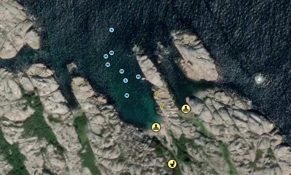
Map of Svennerfyr stranda

Facilities

Available facilities: Playground, Swimming area.

Updated on 10. Jul 2023. Update facilities.

Mooring

Options for mooring in this harbour: Anchoring, Towards land.

Updated on 10. Jul 2023. Update mooring.

Wind protection

Protection next night

93 points

N E S W --> } } } } } } } } } } } } } } } } } } } } } } } } } } } } } } } } } } } } } } } } } } } } } } } } } } } } } } } } } } } } } } } } } } } } } } } } } } } } } } } } } } } } } } } } } } } } } } } } } } } } } } } } } } } } } } } } } } } } } } } } } } } } } } } } } } } } } } } } } } } } } } } } } } } } } } } } } } } } } } } } } } } } } } } } } } } } } } } } } } } } } } } } } } } } } } } } } } } } } } } } } } } } } } } } } } } } } } } } } } } } } } } } } } } } } } } } } } } } } } } } } } } } } } } } } } } } } } } } } } } } } } } } } } } } } } } } } } } } } } } } } } } } } } } } } } } } } } } } } } } } } } } } } } } } } } } } } } } } } } } } } } } } } } } } } } } } } } } } } } } } } } } } } } } } } } } } } } } } } } } } } } } } } } } } } } } } } } } } } } } } } } } } } } } } } } } } } } } } } } } } } } } } } } } } } } } } } } } } } } } } } } } } } } } } } } } } } } } } } } } } } } } } } } } } } } } } } } } } } } } } } } } } } } } } } } } } } } } } } } } } } } } } } } } } } } } } } } } } } } } } } } } } } } } } } } } } } } } } } } } } } } } } } } } } } } } } } } } } } } } } } } } } } } } } } } } } } } } } } } } } } } } } } } } } } } } } } } } } } } } } } } } } } } } } } } } } } } } } } } } } } } } } } } } } } } } } } } } } } } } } } } } } } } } } } } } } } } } } } } } } } } } } } } } } } } } } } } } } } } } } } } } } } } } } } } } } } } } } } } } } } } } } } } } } } } } } } } } } } } } } } } } } } } } } } } } } } } } } } } } } } } } } } } } } } } } } } } } } } } } } } } } } } } } } } } } } } } } } } } } } } } } } } } } } } } } } } } } } } } } } } } } } } } } } } } } } } } } } } } } } } } } } } } } } } } } } } } } } } } } } } } } } } } } } } } } } } } } } } } } } } } } } } } } } } } } } } } } } } } } } } } } } } } } } } } } } } } } } } } } } } } } } } } } } } } } } } } } } } } } } } } } } } } } } } } } } } } } } } } } } } } } } } } } } } } } } } } } } } } } } } } } } } } } } } } } } } } } } } } } } } } } } } } } } } } } } } } } } } } } } Next night 18:00 0:00 6:00 12:00 Tor 01 Mai 18:00 0:00 11m/s 2m/s

Want to know how the wind score works? Then you should read this explanation.

The wind forecasts come from yr.no (Norwegian Meteorological Institute), and was last updated 1 hour and 14 minutes ago (Wednesday 30 April 02:28 PM). The next night score shows you the worst hour between 22:00 and 08:00 the next night. We recommend that you check multiple sources for wind forecasts. windy.com is a good website to show larger wind systems.

The safe directions for this harbour was added at 30. Jul 2023. Click here to edit.

Last visits to Svennerfyr stranda

Thu 05 Sep 2024

RM1260 [MMSI: 258993740]

Sat 31 Aug 2024

RM1260 [MMSI: 258993740]

Thu 27 Jun 2024

DESIDERIA [MMSI: 211701640]

Sat 18 May 2024

HAFGUFA [MMSI: 258120360]

Thu 10 Aug 2023

RM1260 [MMSI: 258993740]

The visits are retrieved from AIS data. You can click to see all visiting ships to Svennerfyr stranda, as well as statistics about the ships that visits

Add this harbour to a journey

Check in now

Choose a different date than today

Important: When you check in to a harbour, you add it to a journey on this website. You are not booking a place in the marina.

Contributors

Users that contributed to this page: TESO and Lars Arne Hoff

harbourmaps.com is updated by the boating community. When you add information, a review or pictures to this page you are listed here with the other contributors (we list your user-name, which can be your real name or a pseudonym).

Closest harbours to Svennerfyr stranda

Filter by

Natural harbour
Marina
Safe wind next night

Order by

ABC
Popularity
Wind score next night

0 harbours

Show more harbours