Trygghamna

Natural harbour

favoritt

Region: Svalbard (71), Svalbard and Jan Mayen (67) and Svalbard (64)

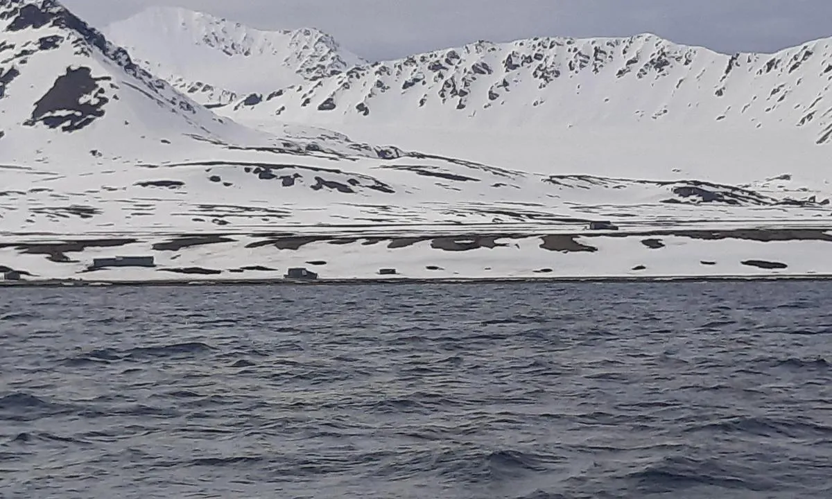
Trygghamna: {"base": "no", "no": "Fjorden g\u00e5r nordvest til syd\u00f8st. God beskyttelse for b\u00f8lger. \r\nH\u00f8yere fjell i vest.", "se": "Fjorden g\u00e5r nordv\u00e4st till syd\u00f6st. Bra skydd mot v\u00e5gor. H\u00f6gre berg i v\u00e4st.", "en": "The fjord runs northwest to southeast. Good protection from waves. Higher mountains in the west.", "da": "Fjorden g\u00e5r nordvest til syd\u00f8st. God beskyttelse mod b\u00f8lger. H\u00f8jere bjerge i vest.", "fr": "Le fjord s'\u00e9tend du nord-ouest au sud-est. Bonne protection contre les vagues.<br>Des montagnes plus hautes \u00e0 l'ouest.", "de": "Der Fjord verl\u00e4uft von Nordwest nach S\u00fcdost. Guten Schutz vor Wellen.<br>H\u00f6here Berge im Westen.", "es": "El fiordo va de noroeste a sureste. Buena protecci\u00f3n contra las olas.<br>Monta\u00f1as m\u00e1s altas en el oeste.", "it": "Il fiordo si estende da nord-ovest a sud-est. Buona protezione contro le onde.<br> Montagne pi\u00f9 alte a ovest.", "pt": "O fiorde vai do noroeste ao sudeste. Boa prote\u00e7\u00e3o contra ondas. <br> Montes mais altos a oeste.", "nl": "De fjord loopt van noordwest naar zuidoost. Goede bescherming tegen golven. Hogere bergen in het westen.", "pl": "Fiord rozci\u0105ga si\u0119 z p\u00f3\u0142nocnego zachodu na po\u0142udniowy wsch\u00f3d. Dobra ochrona przed falami. Wy\u017csze g\u00f3ry na zachodzie.", "uk": "\u0424\u0456\u043e\u0440\u0434 \u043f\u0440\u043e\u0441\u0442\u044f\u0433\u0430\u0454\u0442\u044c\u0441\u044f \u0437 \u043f\u0456\u0432\u043d\u0456\u0447\u043d\u043e\u0433\u043e \u0437\u0430\u0445\u043e\u0434\u0443 \u043d\u0430 \u043f\u0456\u0432\u0434\u0435\u043d\u043d\u0438\u0439 \u0441\u0445\u0456\u0434. \u0425\u043e\u0440\u043e\u0448\u0438\u0439 \u0437\u0430\u0445\u0438\u0441\u0442 \u0432\u0456\u0434 \u0445\u0432\u0438\u043b\u044c.<br>\u0412\u0438\u0449\u0456 \u0433\u043e\u0440\u0438 \u043d\u0430 \u0437\u0430\u0445\u043e\u0434\u0456.", "ro": "Fiordul merge de la nord-vest la sud-est. Protec\u021bie bun\u0103 \u00eempotriva valurilor. Munte mai \u00eenalt \u00een vest.", "tr": "Fiyord kuzeybat\u0131dan g\u00fcneydo\u011fuya do\u011fru gider. Dalgalar i\u00e7in iyi koruma sa\u011flar. Bat\u0131da daha y\u00fcksek da\u011flar.", "el": "\u03a4\u03bf \u03c6\u03b9\u03cc\u03c1\u03b4 \u03b5\u03ba\u03c4\u03b5\u03af\u03bd\u03b5\u03c4\u03b1\u03b9 \u03b1\u03c0\u03cc \u03c4\u03b1 \u03b2\u03bf\u03c1\u03b5\u03b9\u03bf\u03b4\u03c5\u03c4\u03b9\u03ba\u03ac \u03c0\u03c1\u03bf\u03c2 \u03c4\u03b1 \u03bd\u03bf\u03c4\u03b9\u03bf\u03b1\u03bd\u03b1\u03c4\u03bf\u03bb\u03b9\u03ba\u03ac. \u039a\u03b1\u03bb\u03ae \u03c0\u03c1\u03bf\u03c3\u03c4\u03b1\u03c3\u03af\u03b1 \u03b1\u03c0\u03cc \u03c4\u03b1 \u03ba\u03cd\u03bc\u03b1\u03c4\u03b1. \u03a8\u03b7\u03bb\u03cc\u03c4\u03b5\u03c1\u03b1 \u03b2\u03bf\u03c5\u03bd\u03ac \u03c3\u03c4\u03b1 \u03b4\u03c5\u03c4\u03b9\u03ba\u03ac.", "cs": "Fjord se t\u00e1hne od severoz\u00e1padu k jihov\u00fdchodu. Dobr\u00e1 ochrana proti vln\u00e1m. Vy\u0161\u0161\u00ed hory na z\u00e1pad\u011b.", "hu": "A fjord \u00e9szaknyugatr\u00f3l d\u00e9lkeletre fut. J\u00f3 v\u00e9detts\u00e9g a hull\u00e1mok ellen. Magasabb hegyek nyugaton.", "fi": "Fjordri kulkee luoteesta kaakkoon. Hyv\u00e4 suoja aalloilta.<br>Korkeammat vuoret l\u00e4nness\u00e4.", "bg": "\u0424\u0438\u043e\u0440\u0434\u044a\u0442 \u0441\u0435 \u043f\u0440\u043e\u0441\u0442\u0438\u0440\u0430 \u043e\u0442 \u0441\u0435\u0432\u0435\u0440\u043e\u0437\u0430\u043f\u0430\u0434 \u043d\u0430 \u044e\u0433\u043e\u0438\u0437\u0442\u043e\u043a. \u0414\u043e\u0431\u0440\u0430 \u0437\u0430\u0449\u0438\u0442\u0430 \u043e\u0442 \u0432\u044a\u043b\u043d\u0438. \u041f\u043e-\u0432\u0438\u0441\u043e\u043a\u0438 \u043f\u043b\u0430\u043d\u0438\u043d\u0438 \u043d\u0430 \u0437\u0430\u043f\u0430\u0434.", "sr": "\u0424\u0458\u043e\u0440\u0434 \u0441\u0435 \u043f\u0440\u043e\u0442\u0435\u0436\u0435 \u043e\u0434 \u0441\u0435\u0432\u0435\u0440\u043e\u0437\u0430\u043f\u0430\u0434\u0430 \u043a\u0430 \u0458\u0443\u0433\u043e\u0438\u0441\u0442\u043e\u043a\u0443. \u0414\u043e\u0431\u0440\u0430 \u0437\u0430\u0448\u0442\u0438\u0442\u0430 \u043e\u0434 \u0442\u0430\u043b\u0430\u0441\u0430.<br>\u0412\u0438\u0448\u0438 \u043f\u043b\u0430\u043d\u0438\u043d\u0438 \u043d\u0430 \u0437\u0430\u043f\u0430\u0434\u0443.", "et": "Fjord ulatub loodenurgast kagunurka. Hea kaitse lainete eest. K\u00f5rgemad m\u00e4ed l\u00e4\u00e4nes.", "lv": "Fjords virz\u0101s no zieme\u013crietumiem uz dienvidaustrumiem. Laba aizsardz\u012bba pret vi\u013c\u0146iem. Augst\u0101ki kalni rietumos.", "lt": "Fjorda eina i\u0161 \u0161iaur\u0117s vakar\u0173 \u012f pietry\u010dius. Gerai apsaugota nuo bang\u0173. Auk\u0161tesni kalnai vakaruose."}
Flyfoto av Trygghamna

📸 Upload a photo

Show off your photos and help others plan their journey to Trygghamna.harbourmaps.com is created by the sailing community, in a collective effort to make cruising simpler and more fun. Uploading a photo takes less than a minutes and can be done from your phone, tablet or laptop.

📸 Upload a photo

Facilities

We don't have any data on available facilities in this harbour. If you know which facilities are available here, please update this site to help your fellow sailors. Update facilities.

Mooring

Options for mooring in this harbour: Anchoring.

Updated on 4. Jun 2025. Update mooring.

Descriptions and reviews

Do you know this harbour? It's a huge help to other sailors if you add a short description or review of the harbour.

📜 Add description

Map of Trygghamna

Facilities

We don't have any data on available facilities in this harbour. If you know which facilities are available here, please update this site to help your fellow sailors. Update facilities.

Mooring

Options for mooring in this harbour: Anchoring.

Updated on 4. Jun 2025. Update mooring.

Wind protection

Protection next night

77 points

N E S W --> } } } } } } } } } } } } } } } } } } } } } } } } } } } } } } } } } } } } } } } } } } } } } } } } } } } } } } } } } } } } } } } } } } } } } } } } } } } } } } } } } } } } } } } } } } } } } } } } } } } } } } } } } } } } } } } } } } } } } } } } } } } } } } } } } } } } } } } } } } } } } } } } } } } } } } } } } } } } } } } } } } } } } } } } } } } } } } } } } } } } } } } } } } } } } } } } } } } } } } } } } } } } } } } } } } } } } } } } } } } } } } } } } } } } } } } } } } } } } } } } } } } } } } } } } } } } } } } } } } } } } } } } } } } } } } } } } } } } } } } } } } } } } } } } } } } } } } } } } } } } } } } } } } } } } } } } } } } } } } } } } } } } } } } } } } } } } } } } } } } } } } } } } } } } } } } } } } } } } } } } } } } } } } } } } } } } } } } } } } } } } } } } } } } } } } } } } } } } } } } } } } } } } } } } } } } } } } } } } } } } } } } } } } } } } } } } } } } } } } } } } } } } } } } } } } } } } } } } } } } } } } } } } } } } } } } } } } } } } } } } } } } } } } } } } } } } } } } } } } } } } } } } } } } } } } } } } } } } } } } } } } } } } } } } } } } } } } } } } } } } } } } } } } } } } } } } } } } } } } } } } } } } } } } } } } } } } } } } } } } } } } } } } } } } } } } } } } } } } } } } } } } } } } } } } } } } } } } } } } } } } } } } } } } } } } } } } } } } } } } } } } } } } } } } } } } } } } } } } } } } } } } } } } } } } } } } } } } } } } } } } } } } } } } } } } } } } } } } } } } } } } } } } } } } } } } } } } } } } } } } } } } } } } } } } } } } } } } } } } } } } } } } } } } } } } } } } } } } } } } } } } } } } } } } } } } } } } } } } } } } } } } } } } } } } } } } } } } } } } } } } } } } } } } } } } } } } } } } } } } } } } } } } } } } } } } } } } } } } } } } } } } } } } } } } } } } } } } } } } } } } } } } } } } } } } } } } } } } } } } } } } } } } } } } } } } } } } } } } } } } } } } } } } } } } } } } } } } } } } } } } } } } } } } } } } } } } } } } } } } } } } } } } } } } } } } } } } } } } } } } } } } } } } } } } } } } } } } } } } } } Next night 12:00 Søn 15 Jun 18:00 0:00 6:00 12:00 Man 16 Jun 18:00 0:00 6m/s 0m/s

Want to know how the wind score works? Then you should read this explanation.

The wind forecasts come from yr.no (Norwegian Meteorological Institute), and was last updated 1 hour and 38 minutes ago (Sunday 15 June 12:13 PM). The next night score shows you the worst hour between 22:00 and 08:00 the next night. We recommend that you check multiple sources for wind forecasts. windy.com is a good website to show larger wind systems.

The safe directions for this harbour was added at 4. Jun 2025. Click here to edit.

Last visits to Trygghamna

Wed 11 Jun 2025

DIXBAY [MMSI: 244020442]

Wed 14 Aug 2024

AZTEC LADY [MMSI: 228384700]

The visits are retrieved from AIS data. You can click to see all visiting ships to Trygghamna, as well as statistics about the ships that visits

Add this harbour to a journey

Check in now

Choose a different date than today

Important: When you check in to a harbour, you add it to a journey on this website. You are not booking a place in the marina.

Contributors

Users that contributed to this page: TurAnders SY Koia

harbourmaps.com is updated by the boating community. When you add information, a review or pictures to this page you are listed here with the other contributors (we list your user-name, which can be your real name or a pseudonym).

Closest harbours to Trygghamna

Filter by

Natural harbour
Marina
Safe wind next night

Order by

ABC
Popularity
Wind score next night

0 harbours

Show more harbours