























Message from the system: You need to be logged in to write a review. You can either log in or create a new user.

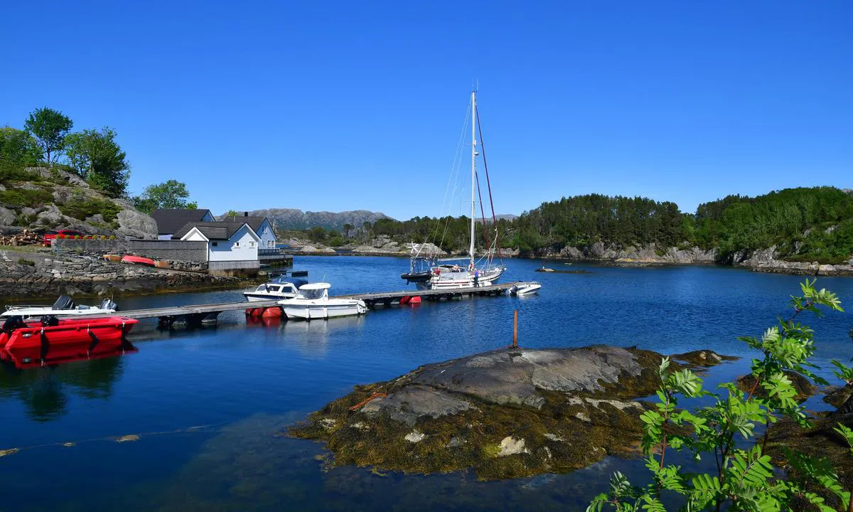
Skjerjehamn naturhamn
Skjerjehamn naturhamn: {"base": "en", "no": "Offentlig flytebrygge. V\u00e6r forsiktig ved innseilingen og bruk kart", "se": "Allm\u00e4n flytbrygga. Var f\u00f6rsiktig vid infarten och anv\u00e4nd karta", "en": "Public floating jetty. Take care at entrance and use map", "da": "Offentlig flydebro. Pas p\u00e5 ved indsejlingen og brug kortet"}
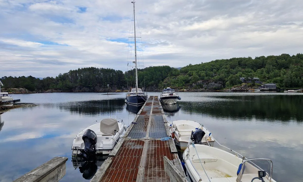
Skjerjehamn naturhamn
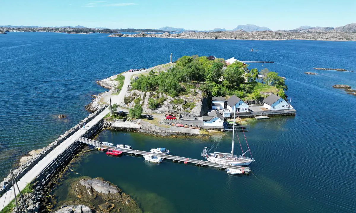
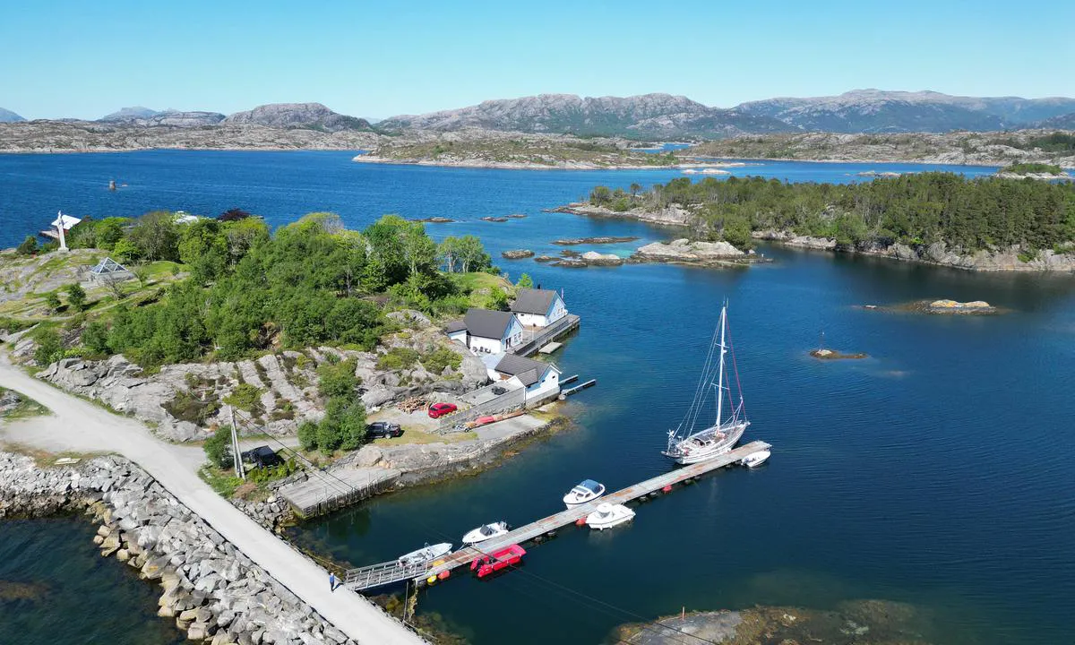
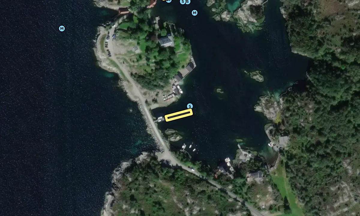
Skjerjehamn naturhamn: {"base": "en", "no": "Enkel flytebrygge, men i god stand. Fort\u00f8yning p\u00e5 sm\u00e5 ringer.<br>Dybden for \u00e5 n\u00e5 flytebryggen er alltid over 4m.<br>Dybde ved enden av flytebryggen (bl\u00e5 er 5m).", "se": "Enkel flytbrygga men i gott skick. F\u00f6rt\u00f6jning vid sm\u00e5 ringar.<br>Djupet f\u00f6r att n\u00e5 flytbryggan \u00e4r alltid \u00f6ver 4 m.<br>Djupet vid \u00e4nden av flytbryggan (bl\u00e5tt \u00e4r 5 m).", "en": "Simple pontoon but in good sate. Tying on small rings.\r\nThe depth to reach the pontoon is always over 4m.\r\nDepth at the end of the pontoon (blue is 5m).", "da": "Simpel ponton, men i god stand. Fort\u00f8jning p\u00e5 sm\u00e5 ringe. Dybden for at n\u00e5 pontonen er altid over 4m. Dybde for enden af pontonen (bl\u00e5 er 5m).", "fr": "Simple ponton mais en bon \u00e9tat. Amarrage sur de petits anneaux.<br> La profondeur pour atteindre le ponton est toujours sup\u00e9rieure \u00e0 4m.<br> Profondeur \u00e0 l'extr\u00e9mit\u00e9 du ponton (en bleu, 5m).", "de": "Einfacher Ponton, aber in gutem Zustand. Festmachen an kleinen Ringen. Die Tiefe, um den Ponton zu erreichen, betr\u00e4gt immer \u00fcber 4m. Tiefe am Ende des Pontons (blau ist 5m).", "es": "Muelle simple pero en buen estado. Amarre en anillos peque\u00f1os.<br> La profundidad para llegar al muelle es siempre superior a 4m.<br> Profundidad al final del muelle (azul es 5m).", "it": "Pontile semplice ma in buono stato. Ormeggio su piccoli anelli. La profondit\u00e0 per raggiungere il pontile \u00e8 sempre superiore a 4m. Profondit\u00e0 alla fine del pontile (blu \u00e8 5m).", "pt": "Cais simples, mas em bom estado. Amarra\u00e7\u00e3o em pequenos an\u00e9is. A profundidade para chegar ao cais \u00e9 sempre superior a 4m. Profundidade no final do cais (azul \u00e9 5m).", "nl": "Eenvoudige ponton maar in goede staat. Bevestigen aan kleine ringen. De diepte om de ponton te bereiken is altijd meer dan 4m. Diepte aan het einde van de ponton (blauw is 5m).", "pl": "Prosty ponton, ale w dobrym stanie. Cumowanie na ma\u0142ych pier\u015bcieniach. G\u0142\u0119boko\u015b\u0107, aby dotrze\u0107 do pontonu, wynosi zawsze ponad 4m. G\u0142\u0119boko\u015b\u0107 na ko\u0144cu pontonu (niebieska to 5m).", "uk": "\u041f\u0440\u043e\u0441\u0442\u0438\u0439 \u043f\u043e\u043d\u0442\u043e\u043d, \u0430\u043b\u0435 \u0432 \u0434\u043e\u0431\u0440\u043e\u043c\u0443 \u0441\u0442\u0430\u043d\u0456. \u0428\u0432\u0430\u0440\u0442\u0443\u0432\u0430\u043d\u043d\u044f \u043d\u0430 \u043c\u0430\u043b\u0435\u043d\u044c\u043a\u0456 \u043a\u0456\u043b\u044c\u0446\u044f. \u0413\u043b\u0438\u0431\u0438\u043d\u0430 \u0434\u043b\u044f \u043f\u0456\u0434\u0445\u043e\u0434\u0443 \u0434\u043e \u043f\u043e\u043d\u0442\u043e\u043d\u0430 \u0437\u0430\u0432\u0436\u0434\u0438 \u0431\u0456\u043b\u044c\u0448\u0435 4 \u043c. \u0413\u043b\u0438\u0431\u0438\u043d\u0430 \u043d\u0430 \u043a\u0456\u043d\u0446\u0456 \u043f\u043e\u043d\u0442\u043e\u043d\u0430 (\u0441\u0438\u043d\u0456\u0439 - 5 \u043c).", "ro": "Ponton simplu, dar \u00een stare bun\u0103. Legare de inele mici. Ad\u00e2ncimea pentru a ajunge la ponton este \u00eentotdeauna peste 4m. Ad\u00e2ncimea la cap\u0103tul pontonului (albastru este 5m).", "tr": "Basit bir ponton ama iyi durumda. K\u00fc\u00e7\u00fck halkalara ba\u011flanma. Pontona ula\u015fmak i\u00e7in olan derinlik her zaman 4 metreden fazlad\u0131r. Pontonun ucundaki derinlik (mavi renk 5m'dir).", "el": "\u0391\u03c0\u03bb\u03ae \u03c0\u03bb\u03c9\u03c4\u03ae \u03b1\u03c0\u03bf\u03b2\u03ac\u03b8\u03c1\u03b1 \u03b1\u03bb\u03bb\u03ac \u03c3\u03b5 \u03ba\u03b1\u03bb\u03ae \u03ba\u03b1\u03c4\u03ac\u03c3\u03c4\u03b1\u03c3\u03b7. \u03a0\u03c1\u03cc\u03c3\u03b4\u03b5\u03c3\u03b7 \u03c3\u03b5 \u03bc\u03b9\u03ba\u03c1\u03bf\u03cd\u03c2 \u03ba\u03c1\u03af\u03ba\u03bf\u03c5\u03c2. \u03a4\u03bf \u03b2\u03ac\u03b8\u03bf\u03c2 \u03b3\u03b9\u03b1 \u03bd\u03b1 \u03c0\u03c1\u03bf\u03c3\u03b5\u03b3\u03b3\u03af\u03c3\u03b5\u03c4\u03b5 \u03c4\u03b7\u03bd \u03c0\u03bb\u03c9\u03c4\u03ae \u03b1\u03c0\u03bf\u03b2\u03ac\u03b8\u03c1\u03b1 \u03b5\u03af\u03bd\u03b1\u03b9 \u03c0\u03ac\u03bd\u03c4\u03b1 \u03c0\u03ac\u03bd\u03c9 \u03b1\u03c0\u03cc 4\u03bc. \u03a4\u03bf \u03b2\u03ac\u03b8\u03bf\u03c2 \u03c3\u03c4\u03bf \u03c4\u03ad\u03bb\u03bf\u03c2 \u03c4\u03b7\u03c2 \u03c0\u03bb\u03c9\u03c4\u03ae\u03c2 \u03b1\u03c0\u03bf\u03b2\u03ac\u03b8\u03c1\u03b1\u03c2 (\u03c4\u03bf \u03bc\u03c0\u03bb\u03b5 \u03b5\u03af\u03bd\u03b1\u03b9 \u03c3\u03c4\u03b1 5\u03bc).", "cs": "Jednoduch\u00e9 molo, ale v dobr\u00e9m stavu. P\u0159ivazov\u00e1n\u00ed na mal\u00e9 kruhy. Hloubka k dosa\u017een\u00ed mola je v\u017edy p\u0159es 4m. Hloubka na konci mola (modr\u00e1 je 5m).", "hu": "Egyszer\u0171 m\u00f3l\u00f3, de j\u00f3 \u00e1llapotban. Kis gy\u0171r\u0171k\u00f6n val\u00f3 kik\u00f6t\u00e9s. A m\u00f3l\u00f3t megk\u00f6zel\u00edt\u0151 v\u00edzm\u00e9lys\u00e9g mindig t\u00f6bb mint 4 m. A m\u00f3l\u00f3 v\u00e9g\u00e9n l\u00e9v\u0151 m\u00e9lys\u00e9g (k\u00e9k) 5 m.", "fi": "Yksinkertainen ponttooni, mutta hyv\u00e4ss\u00e4 kunnossa. Kiinnitt\u00e4minen pieniin renkaisiin. Syvyys ponttoonille saavuttaessa on aina yli 4m. Syvyys ponttoonin p\u00e4\u00e4ss\u00e4 (sininen on 5m).", "bg": "\u041f\u0440\u043e\u0441\u0442 \u043f\u043e\u043d\u0442\u043e\u043d, \u043d\u043e \u0432 \u0434\u043e\u0431\u0440\u043e \u0441\u044a\u0441\u0442\u043e\u044f\u043d\u0438\u0435. \u0412\u0440\u044a\u0437\u0432\u0430\u043d\u0435 \u043d\u0430 \u043c\u0430\u043b\u043a\u0438 \u0445\u0430\u043b\u043a\u0438. \u0414\u044a\u043b\u0431\u043e\u0447\u0438\u043d\u0430\u0442\u0430, \u0437\u0430 \u0434\u0430 \u0434\u043e\u0441\u0442\u0438\u0433\u043d\u0435\u0442\u0435 \u043f\u043e\u043d\u0442\u043e\u043d\u0430, \u0435 \u0432\u0438\u043d\u0430\u0433\u0438 \u043d\u0430\u0434 4\u043c. \u0414\u044a\u043b\u0431\u043e\u0447\u0438\u043d\u0430\u0442\u0430 \u0432 \u043a\u0440\u0430\u044f \u043d\u0430 \u043f\u043e\u043d\u0442\u043e\u043d\u0430 (\u0441\u0438\u043d\u044c\u043e \u0435 5\u043c).", "sr": "Jednostavni ponton, ali u dobrom stanju. Vezuju se na male prstene.<br> Dubina za pristup pontonu je uvek preko 4m.<br> Dubina na kraju pontona (plava je 5m).", "et": "Lihtne pontoon, kuid heas seisukorras. Kinnitamine v\u00e4ikeste r\u00f5ngaste k\u00fclge. S\u00fcgavus pontoonini j\u00f5udmiseks on alati \u00fcle 4m. S\u00fcgavus pontooni l\u00f5pus (sinine on 5m).", "lv": "Vienk\u0101r\u0161s pontons, bet lab\u0101 st\u0101vokl\u012b. Piestiprin\u0101\u0161ana pie mazajiem gredzeniem. Dzi\u013cums, lai sasniegtu pontonu, vienm\u0113r ir liel\u0101ks par 4m. Dzi\u013cums pontona gal\u0101 (zil\u0101 kr\u0101sa ir 5m).", "lt": "Paprastas pontonas, bet geros b\u016bkl\u0117s. Prisiri\u0161kite prie ma\u017e\u0173 \u017eied\u0173. Gylis prie pontono visada vir\u0161ija 4 metrus. Gylis prie pontono galo (m\u0117lyna yra 5m)."}
Satelite image of Skjerjehamn naturhamn

📸 Upload a photo

Show off your photos and help others plan their journey to Skjerjehamn naturhamn.harbourmaps.com is created by the sailing community, in a collective effort to make cruising simpler and more fun. Uploading a photo takes less than a minutes and can be done from your phone, tablet or laptop.

📸 Upload a photo

Facilities

We don't have any data on available facilities in this harbour. If you know which facilities are available here, please update this site to help your fellow sailors. Update facilities.

Mooring

Options for mooring in this harbour: To pier/wharf.

Updated on 21. May 2024. Update mooring.

Contact information

website: Add website

phone: Add phone number

email: Add email

Descriptions and reviews

Dominig ar Foll says:

area

maritime qualities

description

A free alternative to the Skjerjehamn marina.
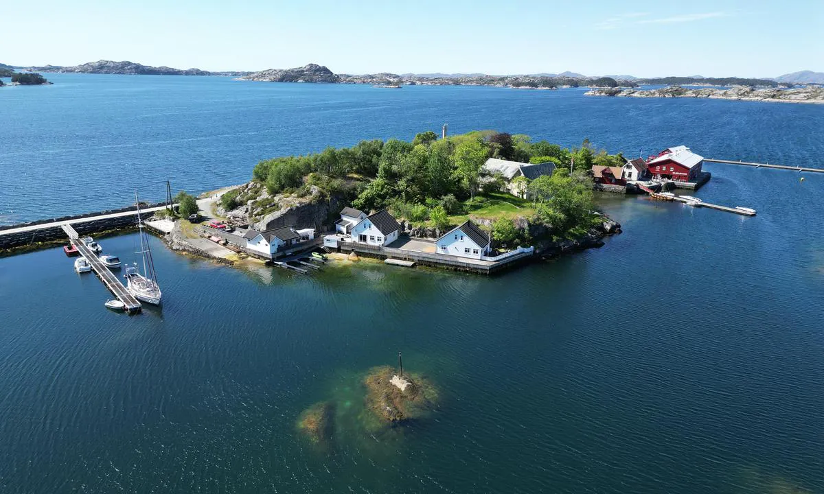
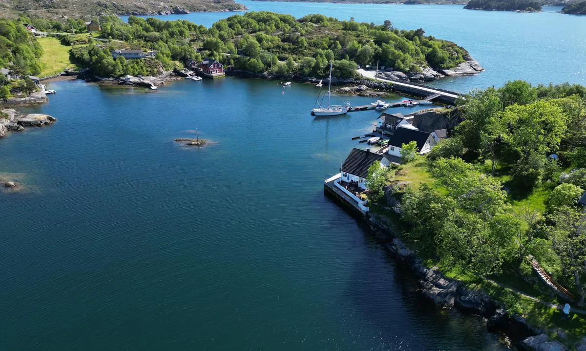
You are better sheltered here, but need to pay attention the chart as a "few" rocks lye around. But if you follow the correct course, you will not see less than 4m deep water. In reality it's very easy and quite a direct route.
The 1.5m rock shown on the chart is at the East end of pontoon. So if you need to moor on the south side you need to stay about 5-10m away from the pontoon east end before turning west toward the pontoon. When reversing from either side you need to remember that specificity. You can see the rock underwater and the two chains that hold the pontoon when standing on the pontoon.
The pontoon is simple but in very good state and very stable.
There is no service at all. You can buy a coffee and use the toilet at the restaurant-café-shop nearby.

1 x helpful | written on 8. Jul 2026 | updated_on 9. Jul 2026

Odd Tufte. S/Y Vindreken says:

area

maritime qualities

description

Floating jetty. Pay good attention at map during entrance. Restaurant nearby.

3 x helpful | written on 21. May 2024

Do you know this harbour? It's a huge help to other sailors if you add a short description or review of the harbour.

📜 Add description

Map of Skjerjehamn naturhamn

Facilities

We don't have any data on available facilities in this harbour. If you know which facilities are available here, please update this site to help your fellow sailors. Update facilities.

Mooring

Options for mooring in this harbour: To pier/wharf.

Updated on 21. May 2024. Update mooring.

Wind protection

Protection next night

93 points

N E S W --> } } } } } } } } } } } } } } } } } } } } } } } } } } } } } } } } } } } } } } } } } } } } } } } } } } } } } } } } } } } } } } } } } } } } } } } } } } } } } } } } } } } } } } } } } } } } } } } } } } } } } } } } } } } } } } } } } } } } } } } } } } } } } } } } } } } } } } } } } } } } } } } } } } } } } } } } } } } } } } } } } } } } } } } } } } } } } } } } } } } } } } } } } } } } } } } } } } } } } } } } } } } } } } } } } } } } } } } } } } } } } } } } } } } } } } } } } } } } } } } } } } } } } } } } } } } } } } } } } } } } } } } } } } } } } } } } } } } } } } } } } } } } } } } } } } } } } } } } } } } } } } } } } } } } } } } } } } } } } } } } } } } } } } } } } } } } } } } } } } } } } } } } } } } } } } } } } } } } } } } } } } } } } } } } } } } } } } } } } } } } } } } } } } } } } } } } } } } } } } } } } } } } } } } } } } } } } } } } } } } } } } } } } } } } } } } } } } } } } } } } } } } } } } } } } } } } } } } } } } } } } } } } } } } } } } } } } } } } } } } } } } } } } } } } } } } } } } } } } } } } } } } } } } } } } } } } } } } } } } } } } } } } } } } } } } } } } } } } } } } } } } } } } } } } } } } } } } } } } } } } } } } } } } } } } } } } } } } } } } } } } } } } } } } } } } } } } } } } } } } } } } } } } } } } } } } } } } } } } } } } } } } } } } } } } } } } } } } } } } } } } } } } } } } } } } } } } } } } } } } } } } } } } } } } } } } } } } } } } } } } } } } } } } } } } } } } } } } } } } } } } } } } } } } } } } } } } } } } } } } } } } } } } } } } } } } } } } } } } } } } } } } } } } } } } } } } } } } } } } } } } } } } } } } } } } } } } } } } } } } } } } } } } } } } } } } } } } } } } } } } } } } } } } } } } } } } } } } } } } } } } } } } } } } } } } } } } } } } } } } } } } } } } } } } } } } } } } } } } } } } } } } } } } } } } } } } } } } } } } } } } } } } } } } } } } } } } } } } } } } } } } } } } } } } } } } } } } } } } } } } } } } } } } } } } } } } } } } } } } } } } } } } } } } } } } } } } } } } } } } } } } } } } } } } } } } } } } } } } } } } Next night 18:00 0:00 6:00 12:00 Tir 25 Aug 18:00 0:00 5m/s 0m/s

Want to know how the wind score works? Then you should read this explanation.

The wind forecasts come from yr.no (Norwegian Meteorological Institute), and was last updated 1 hour and 55 minutes ago (Monday 24 August 12:28 PM). The next night score shows you the worst hour between 22:00 and 08:00 the next night. We recommend that you check multiple sources for wind forecasts. windy.com is a good website to show larger wind systems.

The safe directions for this harbour was added at 8. Jul 2026. Click here to edit.

Last visits to Skjerjehamn naturhamn

Sun 03 Sep 2023

C'NORD MAL [MMSI: 269103330]

The visits are retrieved from AIS data. You can click to see all visiting ships to Skjerjehamn naturhamn, as well as statistics about the ships that visits

Add this harbour to a journey

Check in now

Choose a different date than today

Important: When you check in to a harbour, you add it to a journey on this website. You are not booking a place in the marina.

Contributors

Users that contributed to this page: Dominig ar Foll and Odd Tufte. S/Y Vindreken

harbourmaps.com is updated by the boating community. When you add information, a review or pictures to this page you are listed here with the other contributors (we list your user-name, which can be your real name or a pseudonym).

Closest harbours to Skjerjehamn naturhamn

Filter by

Natural harbour
Marina
Safe wind next night

Order by

ABC
Popularity
Wind score next night

0 harbours

Show more harbours