Linesøya - Rødøya

Natural harbour

favoritt

Region: Norway (3278), Trøndelag (297), Sør-Trøndelag (179), Åfjord (27), Linesøya (2) and Eid (2)

Linesøya - Rødøya: {"base": "fr", "no": "Utsikt over ankringsplassen fra ankringspunktet", "se": "Utsikt \u00f6ver ankarplatsen fr\u00e5n ankringspunkten", "en": "View of the anchorage from the anchor point", "da": "Udsigt over ankerpladsen fra ankerpunktet", "fr": "Vue sur le mouillage depuis le point d\u2019ancrage", "de": "Blick auf den Ankerplatz vom Ankerpunkt", "es": "Vista del fondeadero desde el punto de anclaje", "it": "Vista sull'ancoraggio dal punto di ancoraggio", "pt": "Vista da ancoragem a partir do ponto de amarra\u00e7\u00e3o", "nl": "Uitzicht op de ankerplaats vanaf het ankerpunt", "pl": "Widok na kotwicowisko z kotwicy", "uk": "\u0412\u0438\u0434 \u043d\u0430 \u044f\u043a\u0456\u0440\u043d\u0443 \u0441\u0442\u043e\u044f\u043d\u043a\u0443 \u0437 \u0442\u043e\u0447\u043a\u0438 \u044f\u043a\u043e\u0440\u0456\u043d\u043d\u044f", "ro": "Priveli\u0219te asupra ancorajului de la punctul de ancorare", "tr": "Demirleme noktas\u0131ndan demirleme alan\u0131n\u0131n g\u00f6r\u00fcn\u00fcm\u00fc", "el": "\u0398\u03ad\u03b1 \u03c3\u03c4\u03b7\u03bd \u03b1\u03b3\u03ba\u03c5\u03c1\u03bf\u03b2\u03bf\u03bb\u03af\u03b1 \u03b1\u03c0\u03cc \u03c4\u03bf \u03c3\u03b7\u03bc\u03b5\u03af\u03bf \u03c0\u03c1\u03cc\u03c3\u03b4\u03b5\u03c3\u03b7\u03c2", "cs": "Pohled na kotvi\u0161t\u011b z kotevn\u00edho bodu", "hu": "Kil\u00e1t\u00e1s a horgonyz\u00f3helyre a horgonyz\u00e1si pontr\u00f3l", "fi": "N\u00e4k\u00f6ala ankkuripaikalta", "bg": "\u0418\u0437\u0433\u043b\u0435\u0434 \u043a\u044a\u043c \u0437\u0430\u043a\u043e\u0442\u0432\u044f\u043d\u0435\u0442\u043e \u043e\u0442 \u0442\u043e\u0447\u043a\u0430\u0442\u0430 \u043d\u0430 \u043a\u043e\u0442\u0432\u0435\u043d\u0435", "sr": "Pogled na sidri\u0161te sa ta\u010dke usidrenja", "et": "Vaade ankurduspaigale ankrukohast", "lv": "Skats uz enkura vietu no enkuro\u0161an\u0101s punkta", "lt": "Vaizdas \u012f inkaravimosi viet\u0105 i\u0161 inkaravimo ta\u0161ko"}
Linesøya - Rødøya: {"base": "fr", "no": "Sydinngangen slik den sees fra ankringsplassen", "se": "Sydpassagen, sedd fr\u00e5n ankringsplatsen", "en": "The southern pass, as seen from the anchorage", "da": "Den sydlige passage, som den ses fra forankringspladsen", "fr": "La passe sud, telle qu\u2019on l\u2019aper\u00e7oit depuis le mouillage", "de": "Die s\u00fcdliche Durchfahrt, wie sie vom Ankerplatz aus gesehen wird", "es": "El paso sur, tal como se ve desde el fondeadero", "it": "Il passaggio sud, visto dall'ancoraggio", "pt": "A passagem sul, tal como \u00e9 vista a partir da ancoragem", "nl": "De zuidelijke doorgang, zoals men deze ziet vanaf het ankergebied", "pl": "Przej\u015bcie po\u0142udniowe, takie jakie si\u0119 je widzi z zakotwiczenia", "uk": "\u041f\u0456\u0432\u0434\u0435\u043d\u043d\u0438\u0439 \u043f\u0440\u043e\u0445\u0456\u0434, \u0442\u0430\u043a\u0438\u043c, \u044f\u043a\u0438\u043c \u0439\u043e\u0433\u043e \u0432\u0438\u0434\u043d\u043e \u0437 \u044f\u043a\u043e\u0440\u043d\u043e\u0457 \u0441\u0442\u043e\u044f\u043d\u043a\u0438", "ro": "Trecerea sudic\u0103, a\u0219a cum se vede din ancoraj", "tr": "G\u00fcney ge\u00e7idi, demirleme alan\u0131ndan g\u00f6r\u00fcld\u00fc\u011f\u00fc gibi", "el": "\u0397 \u03bd\u03cc\u03c4\u03b9\u03b1 \u03b4\u03b9\u03ad\u03bb\u03b5\u03c5\u03c3\u03b7, \u03cc\u03c0\u03c9\u03c2 \u03c6\u03b1\u03af\u03bd\u03b5\u03c4\u03b1\u03b9 \u03b1\u03c0\u03cc \u03c4\u03b7\u03bd \u03b1\u03b3\u03ba\u03c5\u03c1\u03bf\u03b2\u03cc\u03bb\u03b7\u03c3\u03b7", "cs": "Ji\u017en\u00ed pr\u016fplav, jak je vid\u011bt z kotvi\u0161t\u011b", "hu": "A d\u00e9li \u00e1tj\u00e1r\u00f3, ahogyan a horgonyz\u00f3helyr\u0151l l\u00e1that\u00f3", "fi": "Etel\u00e4inen v\u00e4yl\u00e4, sellaisena kuin sen n\u00e4kee ankkuripaikalta", "bg": "\u042e\u0436\u043d\u0438\u044f\u0442 \u043f\u0440\u043e\u0445\u043e\u0434, \u043a\u0430\u043a\u0442\u043e \u0441\u0435 \u0432\u0438\u0436\u0434\u0430 \u043e\u0442 \u043a\u043e\u0442\u0432\u0435\u043d\u043e\u0442\u043e \u043c\u044f\u0441\u0442\u043e", "sr": "Ju\u017eni prolaz, onako kako se vidi sa sidri\u0161ta", "et": "L\u00f5unap\u00e4\u00e4s, nagu see paistab ankrualalt", "lv": "Dienvidu \u0161aurslie\u017eu p\u0101reja, t\u0101da, k\u0101da t\u0101 redzama no enkuro\u0161an\u0101s vietas", "lt": "Pietin\u0117 per\u0117ja, toki\u0105, kokia ji matoma i\u0161 inkaravimo vietos"}
Satelite image of Linesøya - Rødøya

📸 Upload a photo

Show off your photos and help others plan their journey to Linesøya - Rødøya.harbourmaps.com is created by the sailing community, in a collective effort to make cruising simpler and more fun. Uploading a photo takes less than a minutes and can be done from your phone, tablet or laptop.

📸 Upload a photo

Facilities

We don't have any data on available facilities in this harbour. If you know which facilities are available here, please update this site to help your fellow sailors. Update facilities.

Mooring

Options for mooring in this harbour: Anchoring, Towards land.

Updated on 29. Dec 2022. Update mooring.

Descriptions and reviews

Chris SV Blue Peter says:

area

maritime qualities

description

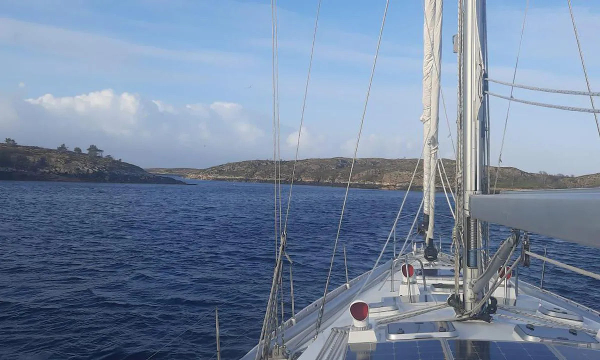
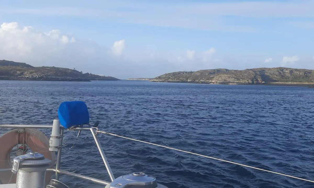
Good anchorage, better sheltered than it appears.
Approach: The East pass is very narrow and can be daunting. It should only be attempted in good conditions.
Anchoring in 12 to 13 meters of water, on sand.

[translated from French with AI]

1 x helpful | written on 12. Apr 2025

Anders Sanne says:

area

maritime qualities

description

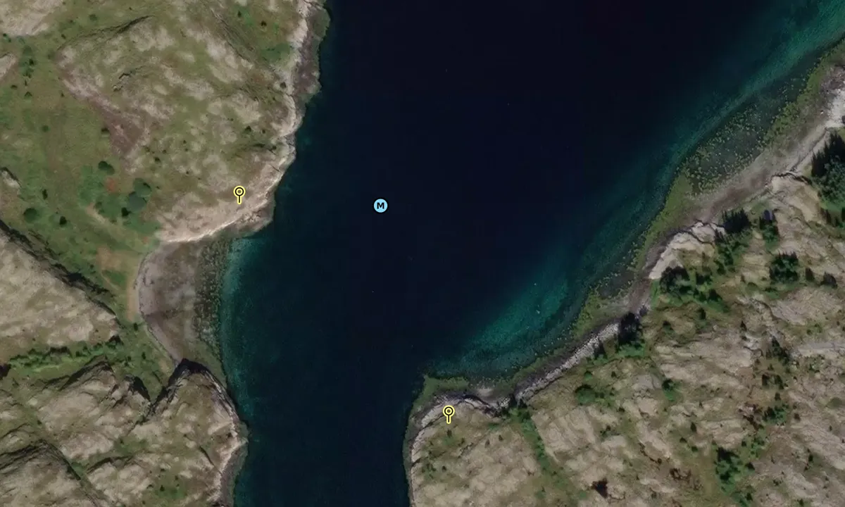
Until the breakwater in Sørgårdsvågen was built in the 1970s, this anchorage was used as a homeport for local fishing boats. Today, the spot is frequently used by long-distance sailors.

On both sides of Raudøysundet, there are several sturdy mooring bolts. Some of these are suitable for mooring to the shore.

[translated from Norwegian with AI]

2 x helpful | written on 29. Dec 2022 | updated_on 29. Dec 2022

Olav Pekeberg says:

description

Anchoring: Anchoring depth 7-10 meters. Sandy bottom and good holding.

[translated from Norwegian with AI]

0 x helpful | written on 4. Jun 2021

Do you know this harbour? It's a huge help to other sailors if you add a short description or review of the harbour.

📜 Add description

Map of Linesøya - Rødøya

Facilities

We don't have any data on available facilities in this harbour. If you know which facilities are available here, please update this site to help your fellow sailors. Update facilities.

Mooring

Options for mooring in this harbour: Anchoring, Towards land.

Updated on 29. Dec 2022. Update mooring.

Wind protection

Protection next night

88 points

N E S W --> } } } } } } } } } } } } } } } } } } } } } } } } } } } } } } } } } } } } } } } } } } } } } } } } } } } } } } } } } } } } } } } } } } } } } } } } } } } } } } } } } } } } } } } } } } } } } } } } } } } } } } } } } } } } } } } } } } } } } } } } } } } } } } } } } } } } } } } } } } } } } } } } } } } } } } } } } } } } } } } } } } } } } } } } } } } } } } } } } } } } } } } } } } } } } } } } } } } } } } } } } } } } } } } } } } } } } } } } } } } } } } } } } } } } } } } } } } } } } } } } } } } } } } } } } } } } } } } } } } } } } } } } } } } } } } } } } } } } } } } } } } } } } } } } } } } } } } } } } } } } } } } } } } } } } } } } } } } } } } } } } } } } } } } } } } } } } } } } } } } } } } } } } } } } } } } } } } } } } } } } } } } } } } } } } } } } } } } } } } } } } } } } } } } } } } } } } } } } } } } } } } } } } } } } } } } } } } } } } } } } } } } } } } } } } } } } } } } } } } } } } } } } } } } } } } } } } } } } } } } } } } } } } } } } } } } } } } } } } } } } } } } } } } } } } } } } } } } } } } } } } } } } } } } } } } } } } } } } } } } } } } } } } } } } } } } } } } } } } } } } } } } } } } } } } } } } } } } } } } } } } } } } } } } } } } } } } } } } } } } } } } } } } } } } } } } } } } } } } } } } } } } } } } } } } } } } } } } } } } } } } } } } } } } } } } } } } } } } } } } } } } } } } } } } } } } } } } } } } } } } } } } } } } } } } } } } } } } } } } } } } } } } } } } } } } } } } } } } } } } } } } } } } } } } } } } } } } } } } } } } } } } } } } } } } } } } } } } } } } } } } } } } } } } } } } } } } } } } } } } } } } } } } } } } } } } } } } } } } } } } } } } } } } } } } } } } } } } } } } } } } } } } } } } } } } } } } } } } } } } } } } } } } } } } } } } } } } } } } } } } } } } } } } } } } } } } } } } } } } } } } } } } } } } } } } } } } } } } } } } } } } } } } } } } } } } } } } } } } } } } } } } } } } } } } } } } } } } } } } } } } } } } } } } } } } } } } } } } } } } } } } } } } } } } } } } } } } } } } } } } } } } } } } } } } } } } } } } } } } } } Next night 18:00 0:00 6:00 12:00 Tor 01 Mai 18:00 0:00 7m/s 2m/s

Want to know how the wind score works? Then you should read this explanation.

The wind forecasts come from yr.no (Norwegian Meteorological Institute), and was last updated 1 hour and 27 minutes ago (Wednesday 30 April 03:27 PM). The next night score shows you the worst hour between 22:00 and 08:00 the next night. We recommend that you check multiple sources for wind forecasts. windy.com is a good website to show larger wind systems.

The safe directions for this harbour was added at 4. Jun 2021. Click here to edit.

Last visits to Linesøya - Rødøya

Sat 15 Jul 2023

KAREELA [MMSI: 235071959]

The visits are retrieved from AIS data. You can click to see all visiting ships to Linesøya - Rødøya, as well as statistics about the ships that visits

Add this harbour to a journey

Check in now

Choose a different date than today

Important: When you check in to a harbour, you add it to a journey on this website. You are not booking a place in the marina.

Contributors

Users that contributed to this page: Chris SV Blue Peter, Anders Sanne and Olav Pekeberg

harbourmaps.com is updated by the boating community. When you add information, a review or pictures to this page you are listed here with the other contributors (we list your user-name, which can be your real name or a pseudonym).

Closest harbours to Linesøya - Rødøya

Filter by

Natural harbour
Marina
Safe wind next night

Order by

ABC
Popularity
Wind score next night

0 harbours

Show more harbours