Tarva Myravågen

Natural harbour

favoritt

Region: Norway (3309), Trøndelag (296), Sør-Trøndelag (177), Ørland (32) and Tarva (4)

Tarva Myravågen: {"base": "en", "no": "Ankringsplassen sett fra s\u00f8r\u00f8st.", "se": "Ankringsplatsen sedd fr\u00e5n sydost.", "en": "The anchorage seen from the south east.", "da": "Ankerpladsen set fra syd\u00f8st.", "fr": "Le mouillage vu du sud-est.", "de": "Der Ankerplatz von S\u00fcdosten gesehen.", "es": "El fondeadero visto desde el sureste.", "it": "L'ancoraggio visto da sud-est.", "pt": "A ancoragem vista do sudeste.", "nl": "Het ankergebied gezien vanuit het zuidoosten.", "pl": "Kotwicowisko widziane z po\u0142udniowego wschodu.", "uk": "\u042f\u043a\u0456\u0440\u043d\u0430 \u0441\u0442\u043e\u044f\u043d\u043a\u0430, \u0432\u0438\u0434 \u0437 \u043f\u0456\u0432\u0434\u0435\u043d\u043d\u043e\u0433\u043e \u0441\u0445\u043e\u0434\u0443.", "ro": "Ancorajul v\u0103zut dinspre sud-est.", "tr": "Demirleme alan\u0131 g\u00fcneydo\u011fudan g\u00f6r\u00fcn\u00fc\u015f\u00fc.", "el": "\u0397 \u03b1\u03b3\u03ba\u03c5\u03c1\u03bf\u03b2\u03cc\u03bb\u03b9\u03b1 \u03cc\u03c0\u03c9\u03c2 \u03c6\u03b1\u03af\u03bd\u03b5\u03c4\u03b1\u03b9 \u03b1\u03c0\u03cc \u03c4\u03b1 \u03bd\u03bf\u03c4\u03b9\u03bf\u03b1\u03bd\u03b1\u03c4\u03bf\u03bb\u03b9\u03ba\u03ac.", "cs": "Kotvi\u0161t\u011b vid\u011bn\u00e9 z jihov\u00fdchodu.", "hu": "A horgonyz\u00f3hely d\u00e9lkeletr\u0151l n\u00e9zve.", "fi": "Ankkuripaikka n\u00e4htyn\u00e4 kaakosta.", "bg": "\u0417\u0430\u043a\u043e\u0442\u0432\u044f\u043d\u0435\u0442\u043e, \u0432\u0438\u0434\u044f\u043d\u043e \u043e\u0442 \u044e\u0433\u043e\u0438\u0437\u0442\u043e\u043a.", "sr": "Sidri\u0161te vi\u0111eno sa jugoistoka.", "et": "Ankruala vaadatuna kagust.", "lv": "Enkurskaites vieta redzama no dienvidaustrumiem.", "lt": "Inkaraviet\u0117 matoma i\u0161 pietry\u010di\u0173."}
Tarva Myravågen: {"base": "en", "no": "V\u00e6r forsiktig, det er noen umerkede (og ikke synlige) steiner i omr\u00e5det rundt den gule markeringen", "se": "Var f\u00f6rsiktig, det finns n\u00e5gra omarkerade (och inte synliga) stenar i omr\u00e5det runt den gula ritningen", "en": "Be careful there are some unmarked (and not visible) rocks in the area around the yellow drawing", "da": "V\u00e6r forsigtig, der er nogle uafm\u00e6rkede (og ikke synlige) klipper i omr\u00e5det omkring den gule markering", "fr": "Attention, il y a des rochers non marqu\u00e9s (et non visibles) dans la zone autour du dessin jaune", "de": "Seien Sie vorsichtig, es gibt einige unmarkierte (und nicht sichtbare) Felsen in dem Bereich um die gelbe Zeichnung", "es": "Tenga cuidado, hay algunas rocas sin marcar (y no visibles) en el \u00e1rea alrededor del dibujo amarillo", "it": "Fai attenzione, ci sono alcune rocce non segnate (e non visibili) nell'area intorno al disegno giallo", "pt": "Cuidado, h\u00e1 algumas rochas n\u00e3o marcadas (e n\u00e3o vis\u00edveis) na \u00e1rea ao redor do desenho amarelo", "nl": "Wees voorzichtig, er zijn enkele ongemarkeerde (en niet zichtbare) rotsen in het gebied rond de gele tekening", "pl": "Uwa\u017caj, w okolicy \u017c\u00f3\u0142tego rysunku znajduj\u0105 si\u0119 nieoznaczone (i niewidoczne) ska\u0142y", "uk": "\u0411\u0443\u0434\u044c\u0442\u0435 \u043e\u0431\u0435\u0440\u0435\u0436\u043d\u0456, \u0454 \u0434\u0435\u044f\u043a\u0456 \u043d\u0435\u043f\u043e\u0437\u043d\u0430\u0447\u0435\u043d\u0456 (\u0456 \u043d\u0435\u0432\u0438\u0434\u0438\u043c\u0456) \u043a\u0430\u043c\u0435\u043d\u0456 \u0432 \u0440\u0430\u0439\u043e\u043d\u0456 \u043d\u0430\u0432\u043a\u043e\u043b\u043e \u0436\u043e\u0432\u0442\u043e\u0433\u043e \u043a\u0440\u0435\u0441\u043b\u0435\u043d\u043d\u044f", "ro": "Fi\u021bi aten\u021bi, exist\u0103 c\u00e2teva st\u00e2nci nemarcate (\u0219i invizibile) \u00een zona din jurul desenului galben", "tr": "Dikkatli olun, sar\u0131 \u00e7izim etraf\u0131ndaki b\u00f6lgede i\u015faretlenmemi\u015f (ve g\u00f6r\u00fcnmeyen) baz\u0131 kayalar vard\u0131r", "el": "\u03a0\u03c1\u03bf\u03c3\u03ad\u03c7\u03b5\u03c4\u03b5, \u03c5\u03c0\u03ac\u03c1\u03c7\u03bf\u03c5\u03bd \u03bc\u03b5\u03c1\u03b9\u03ba\u03ac \u03bc\u03b7 \u03c3\u03b7\u03bc\u03b5\u03b9\u03c9\u03bc\u03ad\u03bd\u03b1 (\u03ba\u03b1\u03b9 \u03cc\u03c7\u03b9 \u03bf\u03c1\u03b1\u03c4\u03ac) \u03b2\u03c1\u03ac\u03c7\u03b9\u03b1 \u03c3\u03c4\u03b7\u03bd \u03c0\u03b5\u03c1\u03b9\u03bf\u03c7\u03ae \u03b3\u03cd\u03c1\u03c9 \u03b1\u03c0\u03cc \u03c4\u03bf \u03ba\u03af\u03c4\u03c1\u03b9\u03bd\u03bf \u03c3\u03c7\u03ad\u03b4\u03b9\u03bf", "cs": "Bu\u010fte opatrn\u00ed, v oblasti kolem \u017elut\u00e9ho zna\u010den\u00ed jsou n\u011bjak\u00e9 neozna\u010den\u00e9 (a neviditeln\u00e9) sk\u00e1ly.", "hu": "Legyen \u00f3vatos, a s\u00e1rga jel\u00f6l\u00e9s k\u00f6rny\u00e9k\u00e9n vannak n\u00e9h\u00e1ny jel\u00f6letlen (\u00e9s nem l\u00e1that\u00f3) szikl\u00e1k.", "fi": "Ole varovainen, alueella keltaisen piirroksen ymp\u00e4rill\u00e4 on joitakin merkitsem\u00e4tt\u00f6mi\u00e4 (ja n\u00e4kym\u00e4tt\u00f6mi\u00e4) kivi\u00e4", "bg": "\u0412\u043d\u0438\u043c\u0430\u043d\u0438\u0435, \u0432 \u0440\u0430\u0439\u043e\u043d\u0430 \u043e\u043a\u043e\u043b\u043e \u0436\u044a\u043b\u0442\u0430\u0442\u0430 \u043c\u0430\u0440\u043a\u0438\u0440\u043e\u0432\u043a\u0430 \u0438\u043c\u0430 \u043d\u044f\u043a\u043e\u0438 \u043d\u0435\u043c\u0430\u0440\u043a\u0438\u0440\u0430\u043d\u0438 (\u0438 \u043d\u0435\u0432\u0438\u0434\u0438\u043c\u0438) \u0441\u043a\u0430\u043b\u0438", "sr": "\u0411\u0443\u0434\u0438\u0442\u0435 \u043e\u043f\u0440\u0435\u0437\u043d\u0438, \u043f\u043e\u0441\u0442\u043e\u0458\u0435 \u043d\u0435\u043a\u0435 \u043d\u0435\u043e\u0431\u0435\u043b\u0435\u0436\u0435\u043d\u0435 (\u0438 \u043d\u0435\u0432\u0438\u0434\u0459\u0438\u0432\u0435) \u0441\u0442\u0435\u043d\u0435 \u0443 \u043e\u0431\u043b\u0430\u0441\u0442\u0438 \u043e\u043a\u043e \u0436\u0443\u0442\u043e\u0433 \u0446\u0440\u0442\u0435\u0436\u0430", "et": "Olge ettevaatlik, kollase joonistuse \u00fcmbruses on m\u00f5ned t\u00e4histamata (ja mitte n\u00e4htavad) kivid", "lv": "Uzmanieties, ap dzelteno z\u012bm\u0113jumu ir da\u017ei neatz\u012bm\u0113ti (un neredzami) akme\u0146i", "lt": "B\u016bkite atsarg\u016bs, nes geltonai nupie\u0161toje srityje yra kai kuri\u0173 nepa\u017eym\u0117t\u0173 (ir nematom\u0173) uol\u0173"}
Satelite image of Tarva Myravågen

📸 Upload a photo

Show off your photos and help others plan their journey to Tarva Myravågen.harbourmaps.com is created by the sailing community, in a collective effort to make cruising simpler and more fun. Uploading a photo takes less than a minutes and can be done from your phone, tablet or laptop.

📸 Upload a photo

Facilities

We don't have any data on available facilities in this harbour. If you know which facilities are available here, please update this site to help your fellow sailors. Update facilities.

Mooring

We don't have any data on how to moor in this harbour. If you know how to moor here, please update this site to help your fellow sailors. Update mooring.

Descriptions and reviews

Journey of Jera says:

area

maritime qualities

description

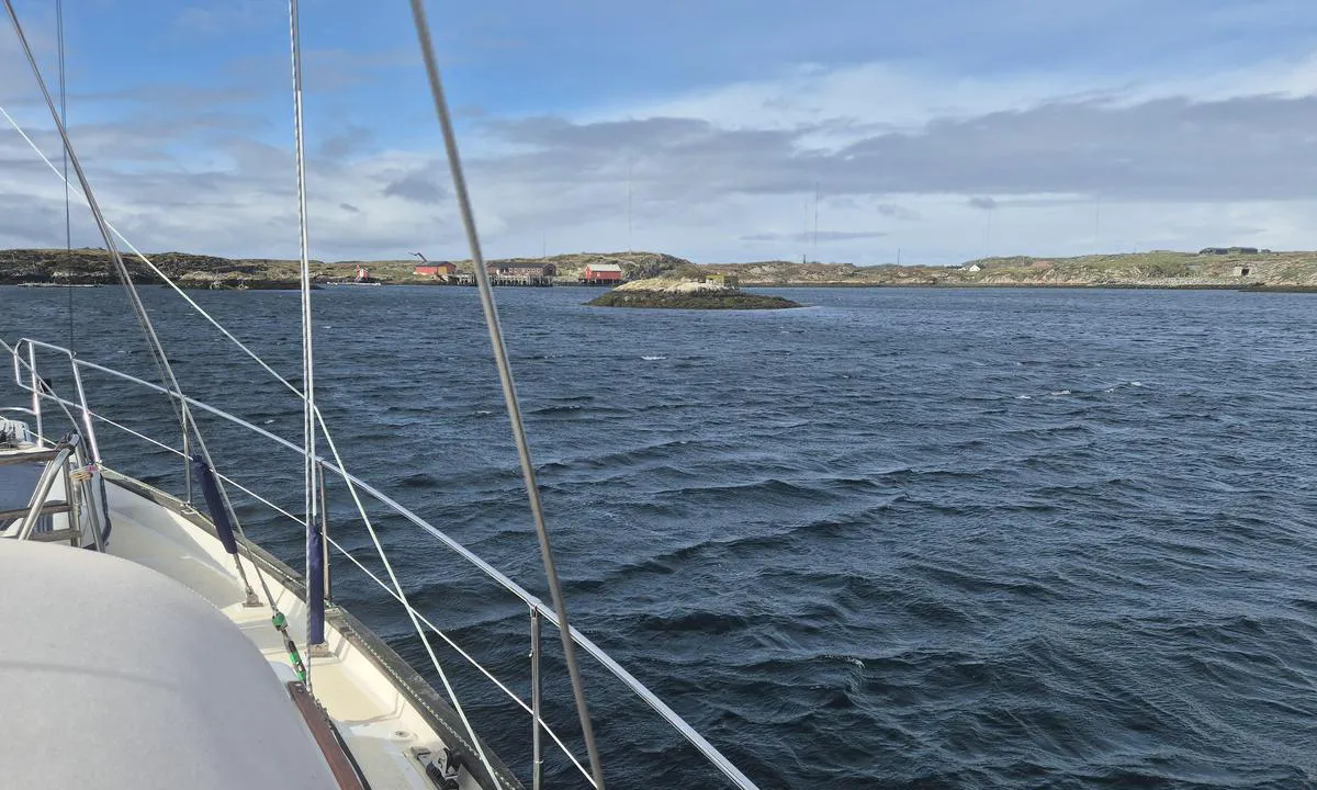
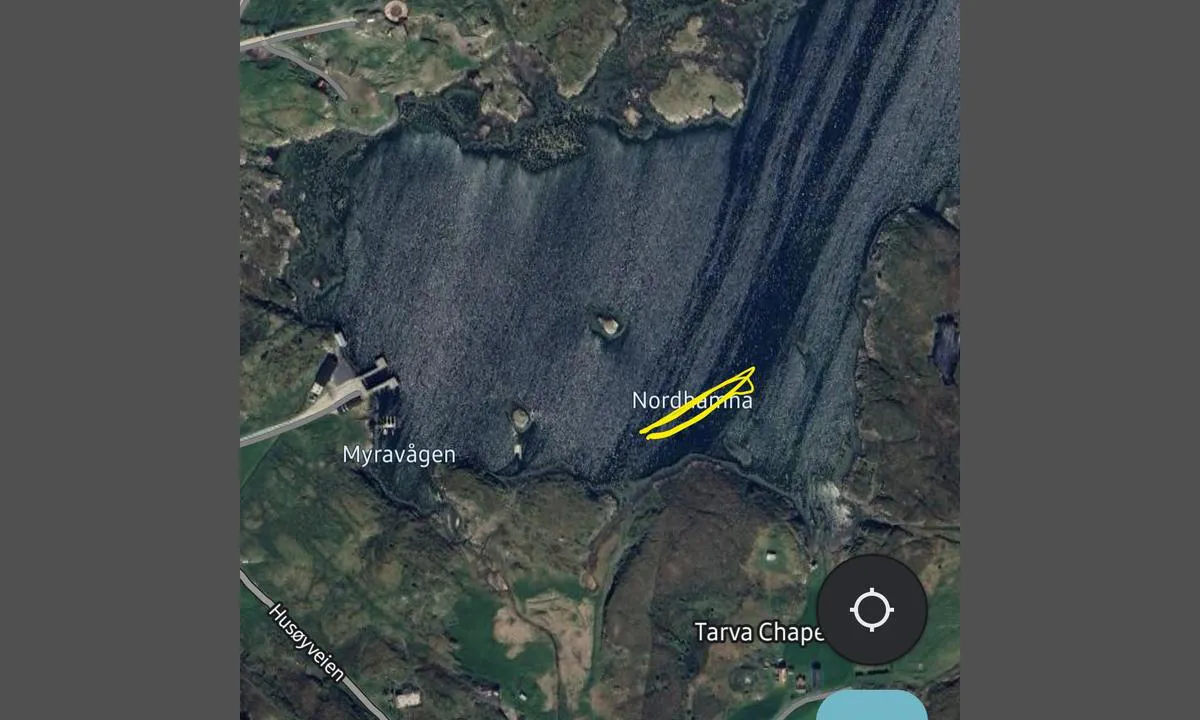
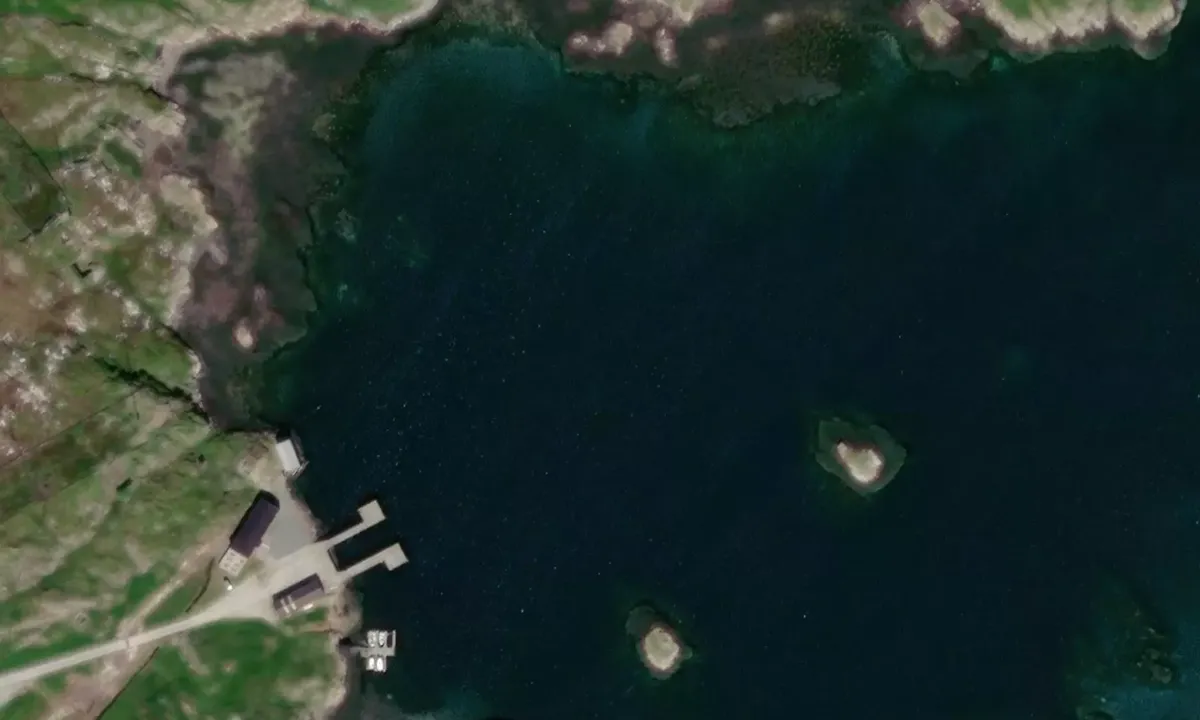
The entry is a bit narrow but clearly marked on the map. The holding is good in sand. The protection from the swell is good. Protection from the wind is okay but the shore all around is quite flat.
Be aware of unmarked rocks in the area (see the picture)

1 x helpful | written on 3. May 2025

Do you know this harbour? It's a huge help to other sailors if you add a short description or review of the harbour.

📜 Add description

Map of Tarva Myravågen

Facilities

We don't have any data on available facilities in this harbour. If you know which facilities are available here, please update this site to help your fellow sailors. Update facilities.

Mooring

We don't have any data on how to moor in this harbour. If you know how to moor here, please update this site to help your fellow sailors. Update mooring.

Wind protection

Protection next night

79 points

N E S W --> } } } } } } } } } } } } } } } } } } } } } } } } } } } } } } } } } } } } } } } } } } } } } } } } } } } } } } } } } } } } } } } } } } } } } } } } } } } } } } } } } } } } } } } } } } } } } } } } } } } } } } } } } } } } } } } } } } } } } } } } } } } } } } } } } } } } } } } } } } } } } } } } } } } } } } } } } } } } } } } } } } } } } } } } } } } } } } } } } } } } } } } } } } } } } } } } } } } } } } } } } } } } } } } } } } } } } } } } } } } } } } } } } } } } } } } } } } } } } } } } } } } } } } } } } } } } } } } } } } } } } } } } } } } } } } } } } } } } } } } } } } } } } } } } } } } } } } } } } } } } } } } } } } } } } } } } } } } } } } } } } } } } } } } } } } } } } } } } } } } } } } } } } } } } } } } } } } } } } } } } } } } } } } } } } } } } } } } } } } } } } } } } } } } } } } } } } } } } } } } } } } } } } } } } } } } } } } } } } } } } } } } } } } } } } } } } } } } } } } } } } } } } } } } } } } } } } } } } } } } } } } } } } } } } } } } } } } } } } } } } } } } } } } } } } } } } } } } } } } } } } } } } } } } } } } } } } } } } } } } } } } } } } } } } } } } } } } } } } } } } } } } } } } } } } } } } } } } } } } } } } } } } } } } } } } } } } } } } } } } } } } } } } } } } } } } } } } } } } } } } } } } } } } } } } } } } } } } } } } } } } } } } } } } } } } } } } } } } } } } } } } } } } } } } } } } } } } } } } } } } } } } } } } } } } } } } } } } } } } } } } } } } } } } } } } } } } } } } } } } } } } } } } } } } } } } } } } } } } } } } } } } } } } } } } } } } } } } } } } } } } } } } } } } } } } } } } } } } } } } } } } } } } } } } } } } } } } } } } } } } } } } } } } } } } } } } } } } } } } } } } } } } } } } } } } } } } } } } } } } } } } } } } } } } } } } } } } } } } } } } } } } } } } } } } } } } } } } } } } } } } } } } } } } } } } } } } } } } } } } } } } } } } } } } } } } } } } } } } } } } } } } } } } } } } } } } } } } } } } } } } } } } } } } } } } } } } } } } } } } } } } } } } } } } } } } } } } } } } } } } } } } } } } } } } } } } } } } } } } } } Next night 12:00 Søn 15 Jun 18:00 0:00 6:00 12:00 Man 16 Jun 18:00 0:00 12m/s 2m/s

Want to know how the wind score works? Then you should read this explanation.

The wind forecasts come from yr.no (Norwegian Meteorological Institute), and was last updated 1 hour and 54 minutes ago (Sunday 15 June 11:28 AM). The next night score shows you the worst hour between 22:00 and 08:00 the next night. We recommend that you check multiple sources for wind forecasts. windy.com is a good website to show larger wind systems.

The safe directions for this harbour was added at 13. Jul 2021. Click here to edit.

Last visits to Tarva Myravågen

The visits are retrieved from AIS data. You can click to see all visiting ships to Tarva Myravågen, as well as statistics about the ships that visits

Add this harbour to a journey

Check in now

Choose a different date than today

Important: When you check in to a harbour, you add it to a journey on this website. You are not booking a place in the marina.

Contributors

Users that contributed to this page: Journey of Jera

harbourmaps.com is updated by the boating community. When you add information, a review or pictures to this page you are listed here with the other contributors (we list your user-name, which can be your real name or a pseudonym).

Closest harbours to Tarva Myravågen

Filter by

Natural harbour
Marina
Safe wind next night

Order by

ABC
Popularity
Wind score next night

0 harbours

Show more harbours